Showing 469 items matching "holland road"
-
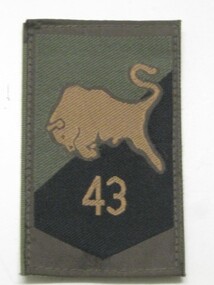 Running Rabbits Military Museum operated by the Upwey Belgrave RSL Sub Branch
Badge
Cloth, khaki with black embroidery Number "43" and leaping bull. 43 Armoured Engineering Batt, Royal Dutch Army.badge/buttons, afghanistan, army -
 Running Rabbits Military Museum operated by the Upwey Belgrave RSL Sub Branch
Badge
Cloth, khaki. Bomb and letters "EOD" (Explosives Ordnance Disposal) Royal Dutch Army. Right sleeve only.Worn by operators, drivers and handlers of EODs.badge/buttons, afghanistan, army -
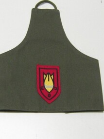 Running Rabbits Military Museum operated by the Upwey Belgrave RSL Sub Branch
Brassard
Sleeve, khaki. Badge in red and yellow letters EOD (Explosives Ordnance Disposal) Royal Dutch Army. Left sleeve only. Worn by operators, drivers and handlers.badge/buttons, afghanistan, army -
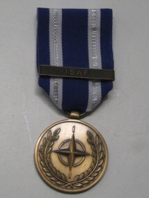 Running Rabbits Military Museum operated by the Upwey Belgrave RSL Sub Branch
Medal, Royal Dutch Army
Blue, white and silver stripes. ISAF on bar (North Atlantic Treaty Assn) Issued by NATO for service in Afghanistanmedals, afghanistan, army -
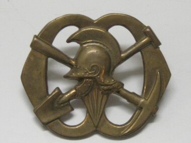 Running Rabbits Military Museum operated by the Upwey Belgrave RSL Sub Branch
Badge
Cap badge brass, Royal Dutch Army Pioneer Battalion. Helmet, with crossed pick and shovel.badge/buttons, army -
 Running Rabbits Military Museum operated by the Upwey Belgrave RSL Sub Branch
Revolver
Make not known. Hexagonal barrel. Belonged to Dutch Army Colonel. No Sn. Made about 1860weapon, pre ww1 -
Running Rabbits Military Museum operated by the Upwey Belgrave RSL Sub Branch
Revolver
Maker Not known caliber not known made about 1860. Belonged to a Dutch Army Colonelweapon, pre ww1 -
 Running Rabbits Military Museum operated by the Upwey Belgrave RSL Sub Branch
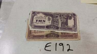
Invasion Money
Japanese |Invasion money for Dutch East Indies !0 Guilder X2 (one with Japanese & English) hand writing on boundary.ephemera, ww2, general -
 Running Rabbits Military Museum operated by the Upwey Belgrave RSL Sub Branch
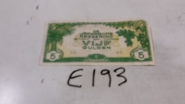
Invasion Money
Japanese Invasion Money 5 Guilder Note ( for Dutch East Indies.)ephemera, ww2, general -
 Running Rabbits Military Museum operated by the Upwey Belgrave RSL Sub Branch
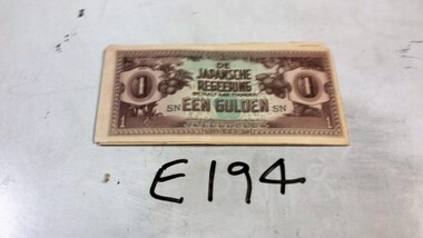
Invasion Money
Japense Invasion money for Dutch East Indies 6 1 Guilder Notes (4 fair, 2 poor)ephemera, ww2, general -
 Running Rabbits Military Museum operated by the Upwey Belgrave RSL Sub Branch
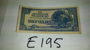
Invasion Money
Japanese Invasion Money for Dutch East Indies (3 X 1/2 Guilder Notes)ephemera, ww2, general -
 Coal Creek Community Park & Museum
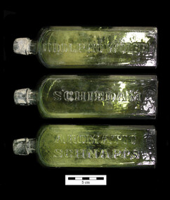
Bottle, glass, Between 1859-1941
TROVE : Argus (Melbourne, Vic. : 1848 - 1957), Monday 17 January 1859, page 7 TO the PHYSICIANS of AUSTRALIA -WOLFE'S SCHIEDAM AROMATIC SCHNAPPS, A superlative Tonic, Diuretic, Anti-Dyspepsic and invigorating Cordial. This medical diet-drink is manufactured soley by the proprietor at his distillery, in Schiedam, in Holland, expressly for medicinal purposes. It is the pure tincture of juniper, distilled from the best barley that can be selected in Europe at any cost. It is flavored and medicated, not by the common harsh berry, but by the choice botanical variety of the aromatic Italian juniper berry, whose more vinous extract is distilled and rectified with its sphirituous solvent, and thus it becomes a concentrated tincture of exquisite flavor and aroma, altogether transcendent in Its cordial and medicinal properties to any alcoholic stimulant now in use In the world. It has been submitted to all the first chemists and physicians in the United Slates, who endorse it over their own signatures as one of tho great essentials of the materia medica. It is now proscribed with great success In gravel, grout, rheumatism, obstruction of the bladder and kidneys, dyspepsia, whether acute or chronic, in general debility, sluggish circulation of the blood, inadequate assimilation of food, and exhausted energy, are acknowledged by the whole medical faculty and attested in their highest written authorities. Put up in quart and pint bottles, enveloped In yellow paper, with the proprietor's name on the bottle-, cork, and label. For sale by all the respectable druggists and merchants. UDOLPHO WOLFE WILKINSON BROTHERS and Co., sole agents for Australia. Depots at Melbourne and Sydney. TROVE : Farmer and Settler (Sydney, NSW : 1906 - 1955), Tuesday 30 March 1915, page 2 TRADING WITH UDOLPHO WOLFE. At the Sydney summons court on Wednesday morning, Laurence Edward Moss and Lawrence David Phillips were charged with having attempted to trade with the enemy by means of a letter addressed and posted to Udolpho Wolfe Company, Hamburg, Germany. There was a second information alleging that on or about December 7 last they attempted to trade with the enemy by means of a cable addressed and trans-mitted to Wolsey, New York. At the request of Mr. Campbell, K.C., who appeared for the defence, an adjournment to April 7 -was granted. Bail was allowed, each in £200, with a surety in £200. TROVE : Age (Melbourne, Vic. : 1854 - 1954), Wednesday 19 November 1941, page 4 WOLFE'S Aromatic SCHNAPPS Wolfe's Schnapps is now distilled in Australia from the original formula of Udolpho Wolfe. It remains, as before, a beverage of unique medicinal properties — Appetising, Refreshing, , Stimulating — as good for women as for men. -Wolfe's 'Schnapps for your health's sake FOR VICTORY-buy War Bonds Now . W.B.157.13 Olive green glass bottle for stopper seal, square in section, slightly tapering toward base, text embossed on three sides, circular ring embossed inside impressed circle on base.Side 1. : 'UDOLOPHO WOLF'S'. Side 2 : 'SCHIEDAM'. Side 3 : 'AROMATIC SCHNAPPS'. Base : an embossed ring inside a round impressed into the square base.schnapps, schiedam, gin, udolpho wolfe -
 Coal Creek Community Park & Museum
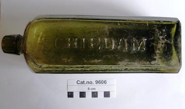
Bottle, glass, c. 1859 - c.1941
TROVE : Argus (Melbourne, Vic. : 1848 - 1957), Monday 17 January 1859, page 7 TO the PHYSICIANS of AUSTRALIA -WOLFE'S SCHIEDAM AROMATIC SCHNAPPS, A superlative Tonic, Diuretlc, Anti-Dyspepsic and invi-gorating Cordial,-This medical diet-drink is manufactured soley by the proprietor at his distillery, in Schiedam, in Holland, expressly for medicinal purposes. It Is the pure tincture of junlper, distilled from the best barley that can be selected in Europe at any cost. It is flavored and medicated, not by the common harsh berry, but by the choice botanical variety of tho aromatic Italian juniper berry, whose more vinous ex-tract is distilled and rectified with its spirituous sol-vent. and thus it becomes a concentrated tincture of exquisite flavor and aroma, altogether transcendant in Its cordial and medicinal properties to any alcoholic stimulant now in use In the world. It has been submitted to all the first chemists and physicians in the United States, who endorse it over their own signatures as one of tho great essentials of the materia medica. It is now proscribed with great success In gravel, grout, rheumatism, obstruction of the bladder and kidneys, dyspepsia, whether acute or chronic, in general debility, sluggish circulation of the blood, inadequate assimilation of food, and exhausted energy, are acknowledged by the whole medical faculty and attested in their highest written authorities. Put up in quart and pint bottles, enveloped In yellow paper, with tho proprietor's name on tho bottle-, cork, and label. For sale by all the respectable druggists and merchants. UDOLPHO WOLFE WILKINSON BROTHERS and Co., sole agents for Australia. Depots at Melbourne and Sydney. TROVE : Age (Melbourne, Vic. : 1854 - 1954), Wednesday 19 November 1941, page 4 WOLFE'S Aromatic SCHNAPPS Wolfe's Schnapps is now distilled in Australia from the original formula of Udolpho Wolfe. It remains, as before, a beverage of unique medicinal properties — Appetising, Re-freshing, , Stimulat-ing — as good for women as for men. -Wolfe's 'Schnapps for j your health's sake FOR VICTORY-buy War Bonds Now . W.B.157.13 Olive green glass bottle, square in section, slightly tapering toward the base, text embossed on three sides, circular ring embossed in shallow pontil shaped impression on base.Side 1 : UDOLPHO WOLFE'S'. Side 2 : 'SCHIEDAM'. Side 3 : 'AROMATIC SCHNAPPS'.schnapps, schiedam, gin -
 Monbulk RSL Sub Branch
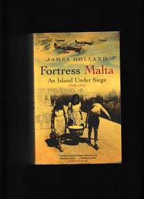
Book, Phoenix, Fortress Malta : an island under siege, 1940-1943, 2003
I history of the siege of Malta, the longest lasting siege in British history.Index, bibliography, notes, ill, maps, p.440.I history of the siege of Malta, the longest lasting siege in British history.world war 1939-1945 - malta, malta - siege 1940-1943 -
 Monbulk RSL Sub Branch
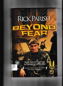
Book, Rick Parish, Beyond fear: Real life in the SAS and pararescue teams, 2009
This is the true story of a man who has taken on all the action he can get. Go behind the scenes with Rick Parish as he serves in the SAS Regiment then as Base Commander and Training Commander for Pararescue at the NSCA, Victorian Division. Every fight is a fight for survival, in a place that only lies Beyond Fear.p,205.non-fictionThis is the true story of a man who has taken on all the action he can get. Go behind the scenes with Rick Parish as he serves in the SAS Regiment then as Base Commander and Training Commander for Pararescue at the NSCA, Victorian Division. Every fight is a fight for survival, in a place that only lies Beyond Fear.sas - history, rick parish - biography -
 Monbulk RSL Sub Branch
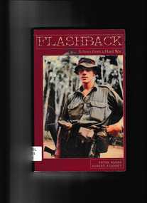
Book, New Holland et al, Flashback : echoes from a hard war, 2003
Flashback is the often harrowing true-life account of seven young Australians who followed the legacy of their fathers and went to war, getting caught up in the brutality of the Vietnam campaign. One dies, six survive after being wounded - only to discover that there are worse things then dying on the battlefield: upholding the ANZAC spirit can come at an enormous physical and emotional cost.Ill, map, p.237.non-fictionFlashback is the often harrowing true-life account of seven young Australians who followed the legacy of their fathers and went to war, getting caught up in the brutality of the Vietnam campaign. One dies, six survive after being wounded - only to discover that there are worse things then dying on the battlefield: upholding the ANZAC spirit can come at an enormous physical and emotional cost. vietnam war 1961-1975 – australian involvement, vietnam war 1961-1975 – personal recollections – australia -
 Monbulk RSL Sub Branch
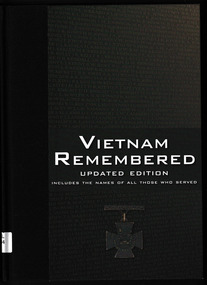
Book, George Pemberton, Vietnam remembered, 2009
This book assesses what the Vietnam War meant - on the battlefield and in Australia. Includes the names of all those who served and images from both the homefront and the front lines.Ill, notes, p.308.non-fictionThis book assesses what the Vietnam War meant - on the battlefield and in Australia. Includes the names of all those who served and images from both the homefront and the front lines.vietnam war 1961-1975, australia - politics and government - 1961-1975 -
 Monbulk RSL Sub Branch
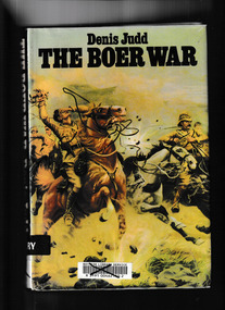
Book, Hart-Davis, MacGibbon, The Boer war, 1977
The Boer War was an epic both of heroism and of barbarism. Fought by the British against the Dutch inhabitants of South Aftrica, the Boer War had an extraordinary cast of characters including Commanders-in chief buller, Roberts and Kitchener, Winston Churchill, Arthur Conan Doyle, Emily Hobhouse, Rudyard Kipling, and Gandhi. The war revealed the ineptitude of the British military, and exposed the corrupt underside of British imperialism . For the first time, Judd and Surridge debunk several myths. There was not, for instance, a straightforward divide between the Boers and British. In fact, the overriding aim of both sides was to maintain European supremacy and to keep Africans and Indians "in their place." Giving us a sense of how the Apartheid era was born.Index, bibliography, ill, maps, p.190.non-fictionThe Boer War was an epic both of heroism and of barbarism. Fought by the British against the Dutch inhabitants of South Aftrica, the Boer War had an extraordinary cast of characters including Commanders-in chief buller, Roberts and Kitchener, Winston Churchill, Arthur Conan Doyle, Emily Hobhouse, Rudyard Kipling, and Gandhi. The war revealed the ineptitude of the British military, and exposed the corrupt underside of British imperialism . For the first time, Judd and Surridge debunk several myths. There was not, for instance, a straightforward divide between the Boers and British. In fact, the overriding aim of both sides was to maintain European supremacy and to keep Africans and Indians "in their place." Giving us a sense of how the Apartheid era was born.south african war 1899-1901, second boer war -
 Monbulk RSL Sub Branch
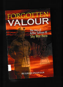
Book, New Holland et al, Forgotten valour : the story of Arthur Sullivan VC, shy war hero, 2006
The story of Arthur Sullivan VC and other Australian soldiers who enlisted in the Great War but went on the fight in the Russian Civil WarIndex, bib, ill, maps, p.304.non-fictionThe story of Arthur Sullivan VC and other Australian soldiers who enlisted in the Great War but went on the fight in the Russian Civil Warmilitary participation - australia, russian civil war - history -
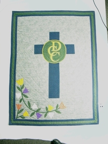 Donvale Christian College
Quilt
This quilt was made to celebrate the 25th Anniversary of the founding of Donvale Christian College. Mrs Anne Suk was one of the few women who held a place on the Board of the School in its early years. She was a member of one of the founding families. This is one of very few items to survive from the early years of the school. It was specifically created to celebrate the 25th anniversary.Machine pieced pale blue Quilt with navy and olive green borders and navy binding. School logo and swag of flowers have been machine pieced and appliqued on the quilt. The quilt has then been hand quilted with navy thread.On the back there is a label with "J.H.E. Suk" machine stitched on it. On a circle appliqued in the centre of the back are embroidered the numbers "1975" and "2000".school, material, quilt, dutch reform, mrs anne suk, donvale christian college, hand quilt -
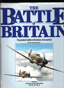 Monbulk RSL Sub Branch
Book, Salamander Books, The Battle of Britain: The greatest battle in the history warfare, 1990
By the summer of 1940, the overwhelming might of the German air force had triumphed over Poland, Norway, France, Holland and Belgium. As the fighters and bombers of the Luftwaffe amassed on the north west coast of Europe, they had no reason to believe that the heavily outnumbered squadrons of the Royal Air Force (RAF) would prove any more difficult to overcome than their earlier opponents. However, these illusions of invulnerability were soon to be shattered in whirling combats over southern England in the conflict that would be known as the Battle of Britain.Index, ill, maps, p.193.non-fictionBy the summer of 1940, the overwhelming might of the German air force had triumphed over Poland, Norway, France, Holland and Belgium. As the fighters and bombers of the Luftwaffe amassed on the north west coast of Europe, they had no reason to believe that the heavily outnumbered squadrons of the Royal Air Force (RAF) would prove any more difficult to overcome than their earlier opponents. However, these illusions of invulnerability were soon to be shattered in whirling combats over southern England in the conflict that would be known as the Battle of Britain.world war 1939-1945 - aerial operations - britain, battle of britain -
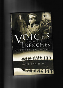 Monbulk RSL Sub Branch
Book, New Holland, Voices from the trenches : letters to home, 2002
The Carthew brothers participated in some of history's most legendary battles, but theirs is more than a story of guns and bullets - it is also a lovestory; of the love and devotion of three brothers for their womenfolk and their country.Ill, maps, p.244.non-fictionThe Carthew brothers participated in some of history's most legendary battles, but theirs is more than a story of guns and bullets - it is also a lovestory; of the love and devotion of three brothers for their womenfolk and their country.world war 1914-1918 - personal narratives, world war 1914-1918 - campaigns - gallipoli -
 Monbulk RSL Sub Branch
Book, Allen & Unwin, Bomber boys, 2017
Bomber Boys is the extraordinary and little known story of more than 100 Dutch airmen stranded in Australia with no country to return to who were joined by a contingent of Australians to make up the RAAF's No. 18 (Netherlands East Indies Squadron). Formed in Canberra in April 1942, the squadron flew operational coastal patrols before eventually being relocated to the secret MacDonald Airfield, north of Pine Creek in the Northern Territory and then Batchelor near Darwin.Bib, ill, maps, p.305.non-fictionBomber Boys is the extraordinary and little known story of more than 100 Dutch airmen stranded in Australia with no country to return to who were joined by a contingent of Australians to make up the RAAF's No. 18 (Netherlands East Indies Squadron). Formed in Canberra in April 1942, the squadron flew operational coastal patrols before eventually being relocated to the secret MacDonald Airfield, north of Pine Creek in the Northern Territory and then Batchelor near Darwin.royal australian air force - 18th squadron, world war two 1939-1945 - aerial operations - australia -
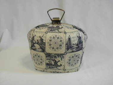 Dutch Australian Heritage Centre Victoria
Tea Cosy (Lined), mid 20th century
This kind of tea cosy was found in just about every Dutch home in the 1950's. It took pride of place on the tea trolley and took the place of, or was an alternative to, the tea lights which also served to keep the teapot warm. It held a large teapot and although it was very effective in keeping the tea warm, after a couple of hours the tea became rather bitter and tasted "stewed". Since the Dutch are not in the habit of adding milk to their tea, the late afternoon cuppa was not always a favourite.A symbol of what the Dutch prize above all, namely "gezelligheid", which means homely cosiness. The afternoon tea ritual ("thee-uurtje") was a very important time of the day as children came home from school to a cosily lit home with their mother presiding over pouring out the tea and distributing biscuits (one at a time!) Half rounded cotton padded teapot warmer (Dutch "theemuts" = tea bonnet) with inserted plywood base. White outside with grey-blue Delft tile motifs, lined with navy blue taffeta and padded with kapok. Metal carrying handle under which there is a clasp which opens and closes the cosy.noneteapot, dutch family life, dutch, immigration, household items -
 Dutch Australian Heritage Centre Victoria
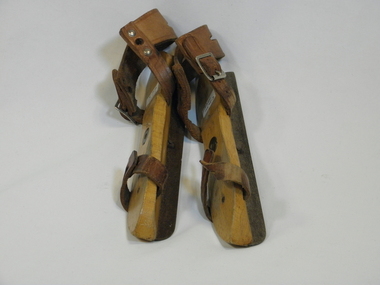
Child-size Wooden Skates, Early 20th century
Skates were and still are widely used in winter time in The Netherlands, when the rivers, canals, creeks, ponds etc. are frozen solid. Paintings out of around 1600-1700 show models of skates very much like the one shown. Even until as recent as 40 years ago, the wooden skates (with steel blade) that are tied to the shoe with leather strap and laces, were widely used in the Netherlands. Even now they are still made in children sizes, because of there flexibility in adjusting to a range of shoe sizes.Skating is a tradition which remains popular.Wooden skates, with brown leather straps. It has a metal strip on the base of the wood, which is necessary for gliding on ice.Letter R for right foot No letter for left footdutch migration skates wood -
 Dutch Australian Heritage Centre Victoria
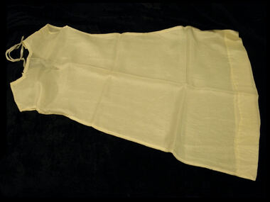
Child's Petticoat, 1945
This petticoat dress was sewn by Mrs. van den Heuvel and her friend M/s Jos Tersteeg for Marjo van den Heuvel to wear under a white dress on the occasion of her cousin Peter Beeker's First Holy Communion.The material was obtained from one of the many parachutes that became available during the Allied offensive of 1944/45. This material was very welcome after the deprivations suffered during the 5 year German occupation. Petticoat to be worn under child's white First Communion dress, made of white parachute silk sewn in extremely tiny stitches by machine and hand. French seams are used for the sides and shoulders; the hem is handsewn. The garment is fastened at the neck with a narrow white satin ribbon.dutch, migration -
 Dutch Australian Heritage Centre Victoria
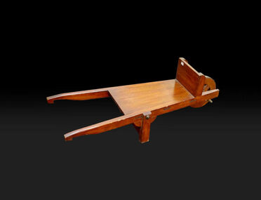
Child-Size Wheelbarrow for Cutting Peat, Unknown, Estimated around 1950
Originated in Drente where cutting peat was one of the main industries. Used together with peat cutter (Item 4143) and peat spade (Item 4142).A rare example referring to the peat cutting industry.Wooden flat-bed wheelbarrow with wooden wheel with metal band. Oak and teak have been used and the item is varnished. Used together with peat cutter (Item 4143) and peat spade (Item 4142).peat cutting. child. wheelbarrow. -
 Dutch Australian Heritage Centre Victoria
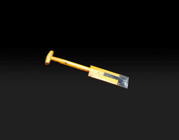
Child Size Peat Cutter
Originated in Drente where cutting peat was one of the main industries. Used together with wheelbarrow (Item 4139) and peat spade (Item 4142). A rare example referring to the peat cutting industry.Metal Peat cutter with wooden handle.Varnished pine has been used and the cutting blade is painted black. Used together with wooden flat-bed wheelbarrow (Item 4139) and peat spade (Item 4142)peat cutting. child. peat-cutter -
 Dutch Australian Heritage Centre Victoria
Child Size Peat Cutting Spade
Wooden peat cutting spade with metal re-enforcement of the cutting edge.Varnished pine has been used and the cutting edge re-enforcement is painted black. Used together with wooden flat-bed wheelbarrow (Item 4139) and peat cutter (Item 4143) -
 Dutch Australian Heritage Centre Victoria
Framed Tile
Tile baking has long been an important industry in The Netherlands with tiles produced for walls and floors as well as at individual requests to commemorate an event or special occasion.A white ceramic tile hand painted in brown with figures of a farming couple from Brabant, a verse, a coat of arms, the words "Noord-Brabant" and various decorative designs. Faintly visible on the back are the ink-stamped words: "plateelbakkerij schoonhoven" (a ceramics factory in Schoonhoven). A handwritten inscription reads: "Sjaan en Ad van Wanrooy, Erp, Nederland. 30 November 1980".tiles, dutch, brabant