Showing 1507 items
matching land purchase
-
 Eltham District Historical Society Inc
Negative - Photograph, George W. Bell, Shillinglaw Cottage, Main Road, Eltham, c.1964
... and land were purchased by the Shire of Eltham as the site... and land were purchased by the Shire of Eltham as the site ...Shillinglaw Cottage on its original site (present day 895 Main Road) showing old picket fence c.1964. The cottage and land were purchased by the Shire of Eltham as the site for a new shire office building. The cottage was destined for demolition but members of the community concerned at losing one of the areas earlist buildings (built c.1859) initiated a fund-raising campaign to save the cottage. In 1964 the cottage was dis-assembled, all the bricks numbered and reassembled several hundred meters to the south on a site between the Gahan house and the Eltham Railway Trestle Bridge (present-day Panther Place), which bcame known as the Eltham Common.This photo forms part of a collection of photographs gathered by the Shire of Eltham for their centenary project book,"Pioneers and Painters: 100 years of the Shire of Eltham" by Alan Marshall (1971). The collection of over 500 images is held in partnership between Eltham District Historical Society and Yarra Plenty Regional Library (Eltham Library) and is now formally known as the 'The Shire of Eltham Pioneers Photograph Collection.' It is significant in being the first community sourced collection representing the places and people of the Shire's first one hundred years.Digital image 4 x 5 inch B&W Negsepp, shire of eltham pioneers photograph collection, eltham, shillinglaw cottage, fences, george w. bell collection, houses, main road -
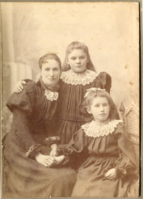 City of Moorabbin Historical Society (Operating the Box Cottage Museum)
Photograph - Photograph, Mrs Carroll c1910, Mrs Carroll c1910, possibly c1910
... migrated from Ireland and purchased land in the East Brighton ( now... from Ireland and purchased land in the East Brighton ( now ...Date unknown: Mrs Caroll and children. In 'Moorabbin A Pictorial History 1862 - 1994 ' by John Cribbin, The Carroll family migrated from Ireland and purchased land in the East Brighton ( now Bentleigh ) area of Henry Dendy's Special Survey 1841. Edward, J.W. & Daniel are shown in the Rate Book 1862 as owner occupiers and owner of property in Tuckers Road, Bryants Road and Centre Road.Photograph is black and white. There are three women in this photograph, a mother and her two children. The mother is sitting down on a chair to the left and her daughter sitting next to her, on the right (they are both holding hands), and her other daughter (child) right in between her mother and sister, with he arm around the mother's shoulder. All three of them are wearing their best dresses that have lace collars. As the clothes are similar to MAV Cat No. 00519 the photo may have been taken c 1910Front of Mount : Yeoman Co 287 Chapel St. Prahran, Victoria.children, chapel st, 287, prahran, carroll edward, carroll, j.w., carroll daniel, ireland, brighton, henry dendy's special survey 1841, market gardeners, pioneers, early settlers, dairy farmers, poultry farmers, bentleigh, mckinnon, ormond, prahran, yeoman photographers co. -
 Flagstaff Hill Maritime Museum and Village
Accessory - Wallet, Daisy Welsh, 1920s
... and seven years later was operating a quarry on land purchased... on land purchased in Wangoom, Warrnambool known as The Dale ...In the words of the Donor, Betty Stone, "The wallet is one of a set of two items. They were designed, hand-sewn sewn and embroidered with raffia by my mother Daisy Elvena (nee Dale) Welsh. Daisy Elvena Dale (born 27 October 1899) daughter of Ellis and Ann (nee Lees) Dale, of Latrigg, Wangoom, Warrnambool, married Raymond Welsh in 1922. A few years later – approximately 1928- Daisy made these two articles, which she used, particularly during the Depression years. The important factor concerning these bags is that they were made with hand-woven cloth cut from a pair of trousers which her grandfather, William Dale brought with him when he left the family farm Back o-'the Low situated in Saddleworth, Yorkshire, England. He arrived in Australia in 1852 and seven years later was operating a quarry on land purchased in Wangoom, Warrnambool known as The Dale Bluestone Quarries. Dale forebears in Yorkshire were first recorded as "clothiers" ( ie weavers of cloth) in the Saddleworth parish records dated 1764; following generations also continued the tradition of producing hand woven cloth as a home industry. The cloth, from which these two bags were made, is evidence of a tradition begun by the Dale family in Saddleworth, Yorkshire more than two hundred and fifty years ago. My mother, Daisy Elvena (nee Dale) Welsh (granddaughter of William Dale) always referred to the cloth, which is at least 160 years old, as a homespun hopsack.The homespun hopsack fabric for the set of bags was part of the clothing brought from England to Australia, an example of emigrant luggage. It also represents a traditional home industry of 'clothiers'. This item is associated with the families of Chamberlain, Dale and Lees. These families are listed in the "Pioneers' Register" for Warrnambool Township and Shire, 1835-1900, published by A.I.G.S. Warrnambool Branch.Embroidered wallet (purse), rectangular, part of a set, the other part being a shopping bag Decorated with embroidered raffia flowers. The bags were made by Daisy Welsh (nee Dale) c. 1928 from homespun "hopsack' fabric of William Dale's trousers, brought to Australia in 1852. Part of the 'Chamberlain Dale Lees Collection' flagstaff hill, warrnambool, shipwrecked coast, flagstaff hill maritime museum, maritime museum, shipwreck coast, flagstaff hill maritime village, great ocean road, chamberlain, dale, lees, stone, betty stone, warrnambool pioneers, clithier, william dale, daisy welsh, wangoom, hopsack, saddleworth, yorkshire, wallet, purse, hand woven, handmade -
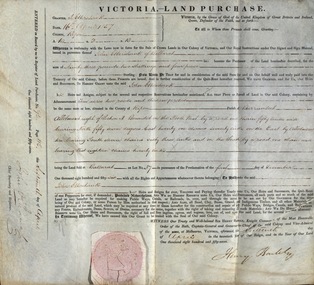 Federation University Historical Collection
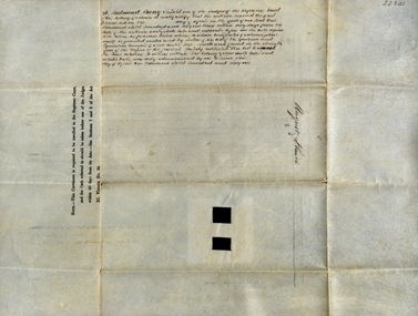
Document, Grant, by Purchase, Parish of Burrumbeet, Victoria, 1857, 1857
... John Ettershank of Ballarat purchased land for Ninety-three... Ettershank of Ballarat purchased land for Ninety-three pounds, two ...John Ettershank of Ballarat purchased land for Ninety-three pounds, two shillings and four pence. This was ten acres, two roods and thirteen perches in the County of Ripon Parish of Burrumbeet. The land sold at Ballarat as Lot No 37. The document was witnessed by Sir Henry Barkly, Knight Commander of the Most Honorable Order of the Bath, Captain-General and Governor-in-Chief of the said Colony and Vice-Admiral, at Melbourne, VictoriaThick cream paper, badly stained. Hand written Official seal Dated 16 April 1857 Signed: Henry Barkly -Governor-in-Chief of the Colony Signed: William C Haines - Chief Secretary and Registrarjohn ettershank, ballarat, county of ripon, parish of burrumbeet, sir henry barkly, captain-general, governor-in-chief -
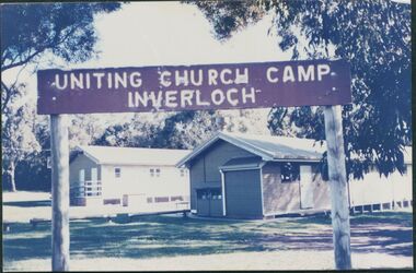 Uniting Church Archives - Synod of Victoria
Photograph, undated
... . Three blocks of land were purchased in 1946 by Miss F. Ritchie... Walsh Collection 1993. Three blocks of land were purchased ...The photograph is from the Brian Walsh Collection 1993. Three blocks of land were purchased in 1946 by Miss F. Ritchie and Mrs H. Grimshaw in Halford St. Inverloch. Three more blocks were purchased in 1948 - 1949. A sixth block was added in 1956. Money was raised by P.F.A. members. Two buildings were purchased from the Government Disposals Authority in 1959. Construction of the camp began in October 1959. Regular working bees were held by P.F.A. members. The first camp was held at the site at Easter 1960. The camp was opened by the Moderator the Rt. Rev. A. Creighton Barr and Flinders Presbytery ministers. In 1998 the decision was taken to sell the site. No buyer was recorded by April 2000.Colour photograph mounted on card showing the exteriors of two camp dormitories in bushland.Uniting Church Camp Inverloch. Gippsland Presbytery. Brian Walsh Collection 1993presbyterian church camp, inverloch, flinders presbytery, p.f.a., miss f. ritchie, mrs. h. grimshaw, rt. rev. creighton barr -
 Westbourne Grammar Heritage Collection
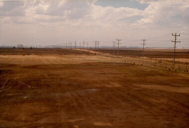
Photograph - The Site for Westbourne 1977
... on demographic research and feasibility studies, fifty acres of land... on demographic research and feasibility studies, fifty acres of land ...In 1975 a School Council subcomittee was formed to select a new principal to instigate the development of secondary schooling at Williamstown Grammar. By 1977 the appointed principal, John Roberts Pascoe, had worked tirelessly assessing options in and around Williamstown and looking for support for the school's expansion plans. He found that support in the Werribee Council and Werribee community, which recognised the potential of an independent school for the expanding area. In 1977, based on demographic research and feasibility studies, fifty acres of land was purchased on Sayers Rd. at Truganina (then Werribee). This photograph shows that land, the site for the new secondary school for Williamstown Grammar, looking east at the corner of Sayers Rd & Marquands Rd, which would be a very different view today.Colour photograph of a cloudy sky and cleared land with a perspective line of telegraph poles extending from the right into the middle background.campus, secondary, expansion -
 Whitehorse Historical Society Inc.
Article, Cole, George Henry (1859 - 1919), n.d
... and general education. A tour of New Zealand raised funds to purchase... Zealand raised funds to purchase land for Tally Ho at Burwood. He ...Article on George Henry Cole - Methodist minister born 7/12/1859 at Mickelham, Victoria, son of William Cole, a selector who arrived in Australia 1849. Ordained 1886, served at Sale, Murtoa, Eaglehawk, Armadale and Geelong. He was a minister of the Primitive Methodist Church. Methodist Union, 1902 enabled him to implement his brainchild, a boy's training farm and gave agricultural instruction to complement spiritual reformation and general education. A tour of New Zealand raised funds to purchase land for Tally Ho at Burwood. He was Superintendent 1904 - 1919. Died 1919. Buried Burwood Cemetary.cole, george henry, cole, william, cole, elizabeth, walton, w.h. (rev), cole, mary euphemia, primitive methodist church, lygon street, carlton methodist mission, tally ho boys home -
 Whitehorse Historical Society Inc.
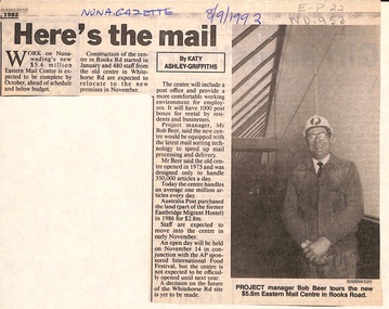
Newspaper - Article, Here's the mail, 8/09/1992
... articles a day. Australia Post purchased the land (former... Post purchased the land (former Eastbridge Migrant Hostel ...Article in Nunawading Gazette. Nunawading's new $5.6 million Eastern Mail Service due to be completed ahead of schedule in October 1992 and below budget. It will have a post office, 1,000 post boxes for rental. Project manager, Bob Beer said it will be equipped with the latest mail sorting equipment to handle 1 million articles a day. Australia Post purchased the land (former Eastbridge Migrant Hostel for $2.8 Million.post offices, rooks road, nunawading, eastern mail centre, beer, bob, eastbridge migrant hostel -
 Port Fairy Historical Society Museum and Archives
Photograph, March 1960
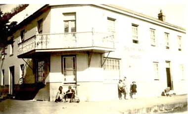
... purchased the land from Atkinson in 1848 and built the building... was built 1848-1854. John Sanders purchased the land from Atkinson ...The Stag Hotel The Stag was built 1848-1854. John Sanders purchased the land from Atkinson in 1848 and built the building as a licensed premises. Over the years it was also used as a Hotel, boarding house and boarding school. It is still used today as Accommodation and a restaurant. This photo is printed in reverse..Black & white photograph of the Sackville street frontage of the Stag Hotel or Seacombe House as now KnownSeacombe House (Back to Front) Port Fairy March 1960hotel, stag, seacombe, sackville street, stag hotel, john sandeers, boarding school, boarding house, coffee palace -
 Ringwood and District Historical Society
Book - Business Records, Collection of 5 Day-books and Ledgers kept by Thomas Grant, Blacksmith, Ringwood, Victoria
... , Victoria, came to Ringwood in 1876. On land purchased from Mr. D..., born in Burwood, Victoria, came to Ringwood in 1876. On land ...GRANT, Thomas (From Short Notes on Ringwood - RDHS) Born 1854, died 1933, aged 79 years. Thomas Grant, born in Burwood, Victoria, came to Ringwood in 1876. On land purchased from Mr. D. Gostick in Whitehorse Road, in the vicinity of the present Drive In Arcade, he built a blacksmith's and coach building shop. In 1880, he married Mary Ann French, of Mulgrave. There were four children, Andrew, Mary, (died in infancy) Thomas, and Margaret. Miss Margaret Grant is a well known resident of Mullum Road. With the opening of the station in 1882, activities in the growing district tended to congregate in its vicinity, and, in 1883, Mr. Grant moved his “smith" to the corner of Adelaide Street. At the same time, he planted out an orchard on his land which ran from Ringwood Street, to Warrandyte Road, and north as far as Mullum Greek. Eventually, about 1910, he sold his business to the Reed Brothers, and retired to the comparatively lighter life of orchardist and market gardener. In 1909, he sold 8 acres of his land to the Lilydale Council. This land, situated in Ringwood Street, behind the Town Hall, is known as the Ringwood Reserve. Mr. & Mrs. Grant were foundation members of the Methodist Church. He was appointed a Trustee in 1879, and served until his death 54 years later. He was an enthusiastic member of many societies, and he held public office in civic affairs. His interests included the Progress Association, Cricket Club, and the Agricultural Society, at whose annual show, he was a regular exhibitor. He served as a Councillor in the Lilydale Shire, repres¬enting Ringwood, from 1889 to 1894, and was a Justice of the Peace. 26278a Ledger belonging to First Blacksmith in Ringwood 1880s. Dark green cover with leather spine and corners. Dark coloured edges on pages. 542 pages, 320 used. 26278b Day book belonging to Thomas Grant, Blacksmith, Ringwood used 1929. Brown covered book with leather spine. First 95 pages torn out. Only two pages of remaining 76 used. 26278c Ledger with alphabetical index - Thomas Grant, Blacksmith, Ringwood - 1888. Green covered book with red spine and corners. Dark coloured edges on pages. 275 pages. Some unused. 26278d T. Grant Blacksmith Day Book. Green covered day book of T. Grant, Blacksmith and General Smithy, Ringwood 1883 . Red square on spine with Day book written on it. Day Book in ink hand written on front spine. 26278e Day book belonging to Thomas Grant, Blacksmith, Ringwood - 1879-1881. Green cover with brown spine and edges. Gold lettering on spine saying Day Book Pages all used. 26278f Collection of receipts, some blotting paper, some pages from the Journal of Architecture, a short story, and drawing with description of an Albert Sociable carriage. -
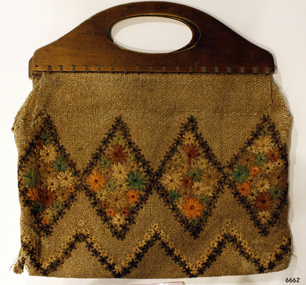 Flagstaff Hill Maritime Museum and Village
Accessory - Bag, Daisy Welsh, 1928
... and seven years later was operating a quarry on land purchased... on land purchased in Wangoom, Warrnambool known as The Dale ...In the words of the Donor, Betty Stone, "This shopping bag is part of a set of two items. The items were designed, hand sewn and embroidered with raffia by my mother Daisy Elvena (nee Dale) Welsh. Daisy Elvena Dale (born 27 October 1899) daughter of Ellis and Ann (nee Lees) Dale, of Latrigg, Wangoom, Warrnambool, married Raymond Welsh in 1922. A few years later – approximately 1928- Daisy made these two articles, which she used, particularly during the Depression years. The important factor concerning these bags is that they were made with hand-woven cloth cut from a pair of trousers that her grandfather, William Dale brought with him when he left the family farm Back o-the Low situated in Saddleworth, Yorkshire, England. He arrived in Australia in 1852 and seven years later was operating a quarry on land purchased in Wangoom, Warrnambool known as The Dale Bluestone Quarries. Dale forebears in Yorkshire were first recorded as "clothiers" ( ie weavers of cloth) in the Saddleworth parish records dated 1764; following generations also continued the tradition of producing hand-woven cloth as a home industry. The cloth, from which these two bags were made, is evidence of a tradition begun by the Dale family in Saddleworth, Yorkshire more than two hundred and fifty years ago. My mother, Daisy Elvena (nee Dale) Welsh (granddaughter of William Dale) always referred to the cloth, which is at least 160 years old, as a homespun hopsack. (Note: For additional information please refer to Betty Stone’s book “Pioneers and Places - A History of three Warrnambool Pioneering Families” ie. Chamberlain, Dale and Lees Families)The homespun hopsack fabric for the set of bags was part of the clothing brought from England to Australia, an example of emigrant luggage. It also represents a traditional home industry of 'clothiers'. This item is associated with the families of Chamberlain, Dale and Lees. These families are listed in the "Pioneers' Register" for Warrnambool Township and Shire, 1835-1900, published by A.I.G.S. Warrnambool Branch.Embroidered shopping Bag, part of a set, the other part being a wallet (purse). Wooden handles and fabric is decorated with embroidered raffia flowers. The bags were made by Daisy Welsh (nee Dale) c. 1928 from homespun "hopsack' fabric of William Dale's trousers, brought to Australia in 1852. Part of the 'Chamberlain Dale Lees Collection' flagstaff hill, warrnambool, shipwrecked coast, flagstaff hill maritime museum, maritime museum, shipwreck coast, flagstaff hill maritime village, great ocean road, chamberlain, dale, lees, stone, betty stone, warrnambool pioneers, clithier, william dale, daisy welsh, wangoom, hopsack, saddleworth, yorkshire, shopping bag, handbag, homespun, handmade -
 Port Fairy Historical Society Museum and Archives
Photograph
... The Stag was built 1848-1854. John Sanders purchased.... John Sanders purchased the land from Atkinson in 1848 and built ...The Stag was built 1848-1854. John Sanders purchased the land from Atkinson in 1848 and built the building as a licensed premises. Over the years it was also used as a Hotel, boarding house and boarding school. It is still used today as Accommodation and a restaurant. This photo has probably been taken in the 1980'sBlack and white Photograph of 2 story building with multi paned windows power pole on corner and telegraph pole to the righthotel, stag, seacombe, inn, john sanders, boarding house, school, coffee palace -
 Greensborough Historical Society
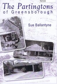
Book, Sue Ballantyne et al, The Partingtons Of Greensborough, 2024
... their arrival in Australia in 184 , including the purchase of land... their arrival in Australia in 184 , including the purchase of land ...History of the Partington Family of Greensborough; from their arrival in Australia in 184 , including the purchase of land in Greensborough and the subsequent compulsory acquisition of some of this land for parks and reserves by various local government authorities. An edited version of family histories by descendant Faye Fort (nee Partington) is included in part 2 of the book.Sourced from family documents and primary sources.Soft Covered book with black and white text and images in black and white, colour, sepiapartington family, greensborough, local history, whatmough park, partingtons flat, yandell reserve, faye fort (nee partington) -
 Bendigo Historical Society Inc.
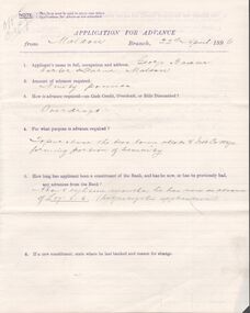
Document - Mortgage and cash credit bond
... the documents related to purchase of land in Maldon and are dated 22... the documents related to purchase of land in Maldon and are dated 22 ...Copy of a cash credit bond between George Baxter, carter, of Maldon and the bank of New South Wales for ninety pounds. Also, an application for advance and two copies of the mortgage documents. all the documents related to purchase of land in Maldon and are dated 22 April 1896. Also, a brown envelope addressed to The Manager bank of New South Wales, Melbourne from Geo Baxter, carter, Maldon "lapsed security" Some other writing in pencil on the envelope.maldon, mortgage, freehold, baxter, cash credit bond -
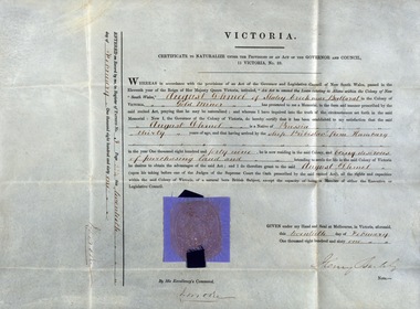 Federation University Historical Collection
Certificate - Document, Certificate to Naturalize under the Provisions of an Act of the Governor and Council, Victoria, 20 February 1861
... and was wishing to purchase land intending to settle for the rest of his... in 1849. He was thirty years old and was wishing to purchase land ...In 1861, August Dhmel of Slatey Creek near Ballarat, applied to be naturalized. He was born in Prussia and arrived by ship from Hamburg in 1849. He was thirty years old and was wishing to purchase land intending to settle for the rest of his life in the Colony of Victoria. This would be granted after taking the Oath before one of the Judges of the Supreme Court. This was taken before Sir Redmond Barry, Knight, in April 1861. A copy of the wording of the oath August Dhmel took hand written on a separate page.Thick cream paper, hand written in ink. Official seal - red and gold - between two pieces of light blue paper and dark blue ribbonSeal Signature of I Moore Date 20 February 1861 Signature of Governor of Victoria, Sir Henry Barklyaugust dhmel, slatey creek, ballarat, naturalize, colony of victoria, judge of the supreme court, redmond barry -
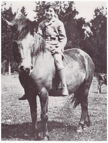 Linton and District Historical Society Inc
Photograph, Gordon Clarke on his Birthday Pony
... Clarke and Mary Jane Newcomen. Gordon Clarke purchased land... Clarke and Mary Jane Newcomen. Gordon Clarke purchased land ...Gordon Clarke (1906-1996) was the grandson of David Clarke who bought Piggoreet West in 1855. His parents were John Clarke and Mary Jane Newcomen. Gordon Clarke purchased land between Piggoreet and Linton, known as the 'Bird Paddock', and began to intensively plant indigenous species, with a view to providing habitat for native birds. This land was afterwards expanded and is now known as the Clarkesdale Bird Sanctuary. In the 1970s, Gordon donated the sanctuary to the Bird Observers Club of Australia.Black and white copy of original photograph a boy sitting bareback on a horse with no bridle.horses, gordon clarke -
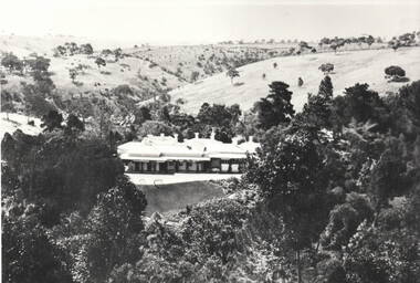 Sunbury Family History and Heritage Society Inc.
Photograph, 'Glenara' Homestead
... moved from NSW to Victoria in 1853 and purchased land... moved from NSW to Victoria in 1853 and purchased land ...'Glenara' is the homestead, which is situated in the Deep Creek valley at Bulla. It was the home of Walter Clark, who moved from NSW to Victoria in 1853 and purchased land on the banks of Deep Creek. Four years later in 1857 his homestead was completed. In the same year Bulla Racing Club held its first annual meet on the property. Later that year, Alister Clark purchased the homestead from the family estate and began developing an extensive rose garden on his property. Alister Clark developed varieties that are adaptable to Australia's climate such as the Lorraine Lee rose and his rose breeding achievements led him to international recognition as a rose breeder of note.A non-digital black and white photograph with a white border of large single story Italianite homestead in a creek valley and surrounded by lightly timbered hillsglenara homestead, bulla bulla, walter clark, alistair clark, roses, rose gardens, deep creek -
 Bendigo Historical Society Inc.
Document - CONNELLY, TATCHELL, DUNLOP COLLECTION: MORTGAGE MR. GEORGE LADSON TO T. LUXTON
... purchase of land in Parish of Macorna, County of Gunbower... between Mr. George Ladson to Mr. T. Luxton Esq. re purchase ...Mortgage document ( 19 August 1892 ) and related correspondence between Mr. George Ladson to Mr. T. Luxton Esq. re purchase of land in Parish of Macorna, County of Gunbower. Includes transfer of land between The Irrigable Estate Coy, to Mr. George Ladson. Letters from Connelly, Tatchell & Dunlop, Thomas Luxton, Irrigable Estate Company, Irrigation & Water supply Trust, George Welch, Railway Hotel, Macorna, draft of document which includes name of John Quick ( unsigned )cottage, miners, george ladson, thomas luxton, john quick, connelly & tatchell, macorna, irrigation and water supply trust, tragowel -
 Federation University Historical Collection
Document, Declaration of Ernest by owners of land in Yendon being held as a site for Public Hall and Free Library; 1891, 1891
... residents of Yendon. Land that had been purchased - being part... of Yendon. Land that had been purchased - being part of Crown ...Document outlining the agreement between five males, all residents of Yendon. Land that had been purchased - being part of Crown Allotment Five Section six, Township of Buninyong East, Parish of Buninyong, County of Grant, has been purchased "as a site for a public hall and free library for the use and benefit of the inhabitants of the Township of Yendon."Thick paper, hand written. Red dots indicate places for signatures Document stamped in green - 0122083 Signatures of; John Winterburn Kemp, Philip Ballantyne, Samuel Henry Mayo, Thomas Dooley, Thomas Watsondeclaration of ernest, land title, free library, public hall, yendon, buninyong, paris of buninyong, county of grant, john winterburn kemp, philip ballantyne, samuel henry mayo, thomas dooley, thomas watson -
 City of Moorabbin Historical Society (Operating the Box Cottage Museum)
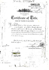
Document - Photocopy of Land Title 1881, c1881
... This is a Certificate of Title for an acre of land... This is a Certificate of Title for an acre of land in 'Tucker's Road' purchased ...This is a Certificate of Title for an acre of land in 'Tucker's Road' purchased by Jabez Gurr in 1881, in the area that was part of the Crown Block known as Henry Dendy's Special Survey 1841, in the Parish of Moorabbin, County of Bourke, Victoria. Following the 'Transfer of Land Statute' allotments in the area of Henry Dendy's Special Survey of 1841 were sold to early settlers. This Certificate of Title shows the passage of history in Moorabbin Shire . Jabez Gurr, a wheelwright, of East Brighton, now Bentleigh East, purchased an acre of land in 'Tucker's Road' , near Centre Road, in 1881. In 1889 he sold to a produce merchant, Robert Smith, and in April 1916 this block was purchased by William Henry George Box, a market gardener and relative of William and Elizabeth Box, who owned the land until 1926. The land was then purchased by Charles John Greenlaw Coates and remained with this family until 1971. All these Family names appear on Councils and Community Boards during the foundation and development of City of Moorabbin3 photocopied pages of the Certificate of Title for approximately 1 acre of land near the corner of Centre Road and Tucker Road, Parish of Moorabbin, County of Bourke, Victoria that was part of the 5,120 acre Henry Dendy Special Survey in Brighton in 1841 and purchased in 1881 by Jabez Gurr. It records subsequent proprietors up to 1971Stamped CANCELLED 12 OCT 1994 (top Right) / Entered in the Register Book / Vol.1245 Fol. 248877/ signed Henry Crowe / Assistant Registrar of Titles / Coat of Arms / VICTORIA / Certificate of Title / UNDER THE ' TRANSFER OF AND STATUTE' /dated ' eleventh day of April one thousand eight / hundred and eighty one' / signed 'Henry Crowe' / Assistant Registrar of Titles/ ENCUMBRANCES REFERRED TO / circular Stamp 'OFFICE OF TITLES VICTORIA' / Drawn and shaded on the left side is the area of land in "Tucker's" Road 3331/3 links fro Centre Road, 150 links x 6662/3 links / The measurements are in linksdendy henry, dendy's special survey 1841, brighton, moorabbin, bentleigh, market gardeners, early settlers, pioneers, wheelwrights, merchants, fruit gardens, markets, smith robert, box william henry george, gurr jabez, county of bourke, victoria, melbourne, land statutes, tucker road, centre road, box william, box elizabeth, box cottage museum -
 Port Fairy Historical Society Museum and Archives
Photograph
... The Stag was built 1848-1854. John Sanders purchased.... John Sanders purchased the land from Atkinson in 1848 and built ...The Stag was built 1848-1854. John Sanders purchased the land from Atkinson in 1848 and built the building as a licensed premises. Over the years it was also used as a Hotel, boarding house, coffee Palace and boarding school. It is still used today as Accommodation and a restaurant. This photo looks like it may have been taken when it was a boarding house.Black and white Photograph of Corner of 2 story building with balcony, 2 males sitting on step and children leaning on wallhotel, seacombe, stag, inn, sackville street, cox street, john sanders, coffee palace, boarding house, boarding school -
 Department of Energy, Environment and Climate Action
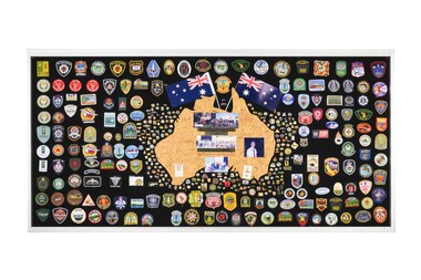
Display board
... of industrial land was purchased at North Altona as a fire cache... of industrial land was purchased at North Altona as a fire cache ...The Forests Commission and its successors continuously encouraged bushfire research and innovation. In 1946 a large parcel of industrial land was purchased at North Altona as a fire cache and workshop. The Altona workshop became a hotbed of new technological innovation… an exhilarating place where lots of things were invented and tested. In fact, a lot of Australia’s pioneering equipment development was led by staff from Altona, often in collaboration with other State forestry and fire authorities. The CSIRO also contributed significantly. The US Forest Service, the US Bureau of Land Management and US State agencies such as the California Department of Forestry and Fire (CalFire) as well as the Canadian Forest Service faced similar challenges and proved strong and willing partners in sharing knowledge, ideas, equipment and expertise over many decades. This collection of badges is testament to the relationships that were forged across the globe with the Altona workshop. Large display panel featuring many fire service badgesforests commission victoria (fcv), bushfire, bushfire aviation -
 Eltham District Historical Society Inc
Document, 14 Stokes Place, Eltham: Building plans and contracts, 1979c
... . The land was purchased in May 1979 and the home built by Peter.... The land was purchased in May 1979 and the home built by Peter ...14 Stokes Place was the home of Peter and Carla Vermey. The land was purchased in May 1979 and the home built by Peter and Carla Vermey after the developer, Macquarie Builders went bankrupt. Sold October 2017 by Morrison and Kleeman Real Estate. Stokes Place was part of the Stokes Orchard Estate which was developed from the break-up of the the orchard owned by Frank Stokes who lived on the northeast corner of Nyora Road and Eucalyptus Road. His daughter Beryl advised that the Shire had levied a rate assessment on individual parcels of land within the orchard which became unaffordable resulting in its sub-division and sell off. The Stokes Orchard Estate was developed by Macquarie Builders in two stages starting with stage 1 in 1976. Stokes Place was part of Stage 2 in 1979. The Estate was bounded between Nyora Road, Eucalyptus Road, Diosma Road and Stokes Place. The original orchard only just reached the left most portions of Stokes Place and did not go fully up to Diosma, rather to just beyond the extant of Stokes Place. Stokes Place was known within the family as "The Oats" as that is where they grew oats. Frank Stokes moved to Eltham c.1945 after visiting Harold Bird to view his orchard, located diagonally opposite Stokes Orchard from the intersection of Eucalyptus Road, Pitt Street and Nyora Road. It was on Harold Bird's recommendation that Frank purchased the land.The Stokes Orchard Estate collection is typical of housing developments of the late 1970s and 1980s. It was one of the earliest estates in Eltham following the nearby Woodridge Estate development.Digital file30 digital files scanned from documents provided on loan by Peter and Carla Vermeystokes place, eltham, stokes orchard, stokes orchard estate, streets, houses, peter and carla vermey -
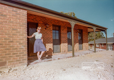
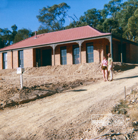 Eltham District Historical Society Inc
Photograph, 14 Stokes Place, Eltham, April 1980, 1980
... . The land was purchased in May 1979 and the home built by Peter.... The land was purchased in May 1979 and the home built by Peter ...14 Stokes Place was the home of Peter and Carla Vermey. The land was purchased in May 1979 and the home built by Peter and Carla Vermey after the developer, Macquarie Builders went bankrupt. Sold October 2017 by Morrison and Kleeman Real Estate. Stokes Place was part of the Stokes Orchard Estate which was developed from the break-up of the the orchard owned by Frank Stokes who lived on the northeast corner of Nyora Road and Eucalyptus Road. His daughter Beryl advised that the Shire had levied a rate assessment on individual parcels of land within the orchard which became unaffordable resulting in its sub-division and sell off. The Stokes Orchard Estate was developed by Macquarie Builders in two stages starting with stage 1 in 1976. Stokes Place was part of Stage 2 in 1979. The Estate was bounded between Nyora Road, Eucalyptus Road, Diosma Road and Stokes Place. The original orchard only just reached the left most portions of Stokes Place and did not go fully up to Diosma, rather to just beyond the extant of Stokes Place. Stokes Place was known within the family as "The Oats" as that is where they grew oats. Frank Stokes moved to Eltham c.1945 after visiting Harold Bird to view his orchard, located diagonally opposite Stokes Orchard from the intersection of Eucalyptus Road, Pitt Street and Nyora Road. It was on Harold Bird's recommendation that Frank purchased the land.The Stokes Orchard Estate collection is typical of housing developments of the late 1970s and 1980s. It was one of the earliest estates in Eltham following the nearby Woodridge Estate development.Digital fileScanned from a print contained in owner's photo album (81 prints in total digitised)stokes place, eltham, stokes orchard, stokes orchard estate, streets, houses, peter and carla vermey -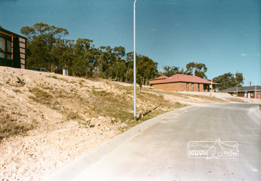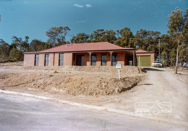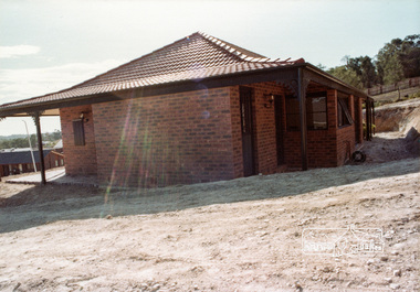
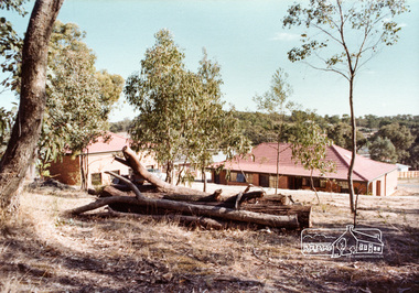
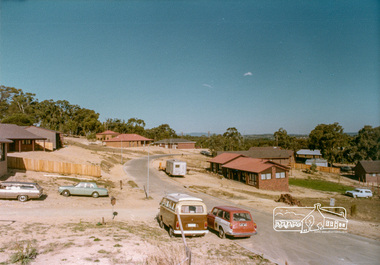 Eltham District Historical Society Inc
Photograph, Stokes Place, Eltham, April 1980; viewed from near no. 10 looking southeast, 1980
... . The land was purchased in May 1979 and the home built by Peter.... The land was purchased in May 1979 and the home built by Peter ...14 Stokes Place was the home of Peter and Carla Vermey. The land was purchased in May 1979 and the home built by Peter and Carla Vermey after the developer, Macquarie Builders went bankrupt. Sold October 2017 by Morrison and Kleeman Real Estate. Stokes Place was part of the Stokes Orchard Estate which was developed from the break-up of the the orchard owned by Frank Stokes who lived on the northeast corner of Nyora Road and Eucalyptus Road. His daughter Beryl advised that the Shire had levied a rate assessment on individual parcels of land within the orchard which became unaffordable resulting in its sub-division and sell off. The Stokes Orchard Estate was developed by Macquarie Builders in two stages starting with stage 1 in 1976. Stokes Place was part of Stage 2 in 1979. The Estate was bounded between Nyora Road, Eucalyptus Road, Diosma Road and Stokes Place. The original orchard only just reached the left most portions of Stokes Place and did not go fully up to Diosma, rather to just beyond the extant of Stokes Place. Stokes Place was known within the family as "The Oats" as that is where they grew oats. Frank Stokes moved to Eltham c.1945 after visiting Harold Bird to view his orchard, located diagonally opposite Stokes Orchard from the intersection of Eucalyptus Road, Pitt Street and Nyora Road. It was on Harold Bird's recommendation that Frank purchased the land.The Stokes Orchard Estate collection is typical of housing developments of the late 1970s and 1980s. It was one of the earliest estates in Eltham following the nearby Woodridge Estate development.Digital fileScanned from a print contained in owner's photo album (81 prints in total digitised)stokes place, eltham, stokes orchard, stokes orchard estate, streets, houses, peter and carla vermey -
 Eltham District Historical Society Inc
Photograph, 14 Stokes Place, Eltham, April 1980, 1980
... . The land was purchased in May 1979 and the home built by Peter.... The land was purchased in May 1979 and the home built by Peter ...14 Stokes Place was the home of Peter and Carla Vermey. The land was purchased in May 1979 and the home built by Peter and Carla Vermey after the developer, Macquarie Builders went bankrupt. Sold October 2017 by Morrison and Kleeman Real Estate. Stokes Place was part of the Stokes Orchard Estate which was developed from the break-up of the the orchard owned by Frank Stokes who lived on the northeast corner of Nyora Road and Eucalyptus Road. His daughter Beryl advised that the Shire had levied a rate assessment on individual parcels of land within the orchard which became unaffordable resulting in its sub-division and sell off. The Stokes Orchard Estate was developed by Macquarie Builders in two stages starting with stage 1 in 1976. Stokes Place was part of Stage 2 in 1979. The Estate was bounded between Nyora Road, Eucalyptus Road, Diosma Road and Stokes Place. The original orchard only just reached the left most portions of Stokes Place and did not go fully up to Diosma, rather to just beyond the extant of Stokes Place. Stokes Place was known within the family as "The Oats" as that is where they grew oats. Frank Stokes moved to Eltham c.1945 after visiting Harold Bird to view his orchard, located diagonally opposite Stokes Orchard from the intersection of Eucalyptus Road, Pitt Street and Nyora Road. It was on Harold Bird's recommendation that Frank purchased the land.The Stokes Orchard Estate collection is typical of housing developments of the late 1970s and 1980s. It was one of the earliest estates in Eltham following the nearby Woodridge Estate development.Digital fileScanned from a print contained in owner's photo album (81 prints in total digitised)stokes place, eltham, stokes orchard, stokes orchard estate, streets, houses, peter and carla vermey -
 Eltham District Historical Society Inc
Photograph, 14 Stokes Place, Eltham, April 1980, 1980
... . The land was purchased in May 1979 and the home built by Peter.... The land was purchased in May 1979 and the home built by Peter ...14 Stokes Place was the home of Peter and Carla Vermey. The land was purchased in May 1979 and the home built by Peter and Carla Vermey after the developer, Macquarie Builders went bankrupt. Sold October 2017 by Morrison and Kleeman Real Estate. Stokes Place was part of the Stokes Orchard Estate which was developed from the break-up of the the orchard owned by Frank Stokes who lived on the northeast corner of Nyora Road and Eucalyptus Road. His daughter Beryl advised that the Shire had levied a rate assessment on individual parcels of land within the orchard which became unaffordable resulting in its sub-division and sell off. The Stokes Orchard Estate was developed by Macquarie Builders in two stages starting with stage 1 in 1976. Stokes Place was part of Stage 2 in 1979. The Estate was bounded between Nyora Road, Eucalyptus Road, Diosma Road and Stokes Place. The original orchard only just reached the left most portions of Stokes Place and did not go fully up to Diosma, rather to just beyond the extant of Stokes Place. Stokes Place was known within the family as "The Oats" as that is where they grew oats. Frank Stokes moved to Eltham c.1945 after visiting Harold Bird to view his orchard, located diagonally opposite Stokes Orchard from the intersection of Eucalyptus Road, Pitt Street and Nyora Road. It was on Harold Bird's recommendation that Frank purchased the land.The Stokes Orchard Estate collection is typical of housing developments of the late 1970s and 1980s. It was one of the earliest estates in Eltham following the nearby Woodridge Estate development.Digital fileScanned from a print contained in owner's photo album (81 prints in total digitised)stokes place, eltham, stokes orchard, stokes orchard estate, streets, houses, peter and carla vermey