Showing 542 items
matching landmark
-
 Federation University Historical Collection
Documents - Reports, Paul Cropper, Myths & Monsters Conference Papers, 10/2001
The Myths and Monsters conference was something of a landmark in Australian mystery animal research. It was the first cryptozoological conference held in Australia, and the first time Australia's leading researchers had been able to present their findings and meet with others working in the same field. 82 page proceedings of the Myths and Monsters Conference printed onto white paper. The following topics were presented: * A brief History of Australian Cryptozoology (Paul Cropper) * Would the Real Orang-Utan Please Stand Up and be Counted? In search of unidentified relic hominoids in Southeast Asia (Helmut Loofs-Wissowa) * Strange Creatures on the Antipodean UFO trail (Bill Chalker) * The Bunyip (Gary Opit) * Sightings of Some Anomolous Sea Creatures (Malcolm Smith) * Investigating Cryptic Hominids (Yowies) in the Blue Mountains of New South Wales (MIchael Hallett & David McBean) * "High Strangeness" in Yowie Reports (Tony Healy) * The Mystery of the Australian Big Cat: A Brief Summary (Peter Chapple) * Quest for the Thylacine (Peter Chapple) [Australian Animal Folklore Collection]Signed on cover "Simon Townsend"australian animal folklore collection, paul cropper, ruby lang, helmut loofs wissowa, bill chalker, gary opit, malcolm smith, michael hallett, david mcbean, tony healy, peter chapple, bunyip, blue montains, yowie, thylacine, big cat, puma, panther, ufo, goolma, woodenbong, narrabeen lakes, cecil mcgann, dorothy middleton, lee kelly, brown bittern, bay monster, simon moir, footprints, blue mountains cryptid, prehistoric bipedal primates, gigantopithecus, meganthropus, homo rudolfensis, homo habilis, homo erectus, homo ergaster, hominid, bigfoot, psychic phenomena, black panther, lake monster, blue labyrinth, australian rare fauna research association, marsupial lion, thylocoleo carnifex, australian big cat, tasmanian devil, sarcophilus harrisi, eric guiler, yellingbo, thylacinus cynocephalus, tantanoola tiger, rilla martin, mundrabilla, predatory animal, mythical, myth, folklore -
 Kew Historical Society Inc
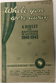
Booklet, The Argus and Australasian Ltd, While You Were Away : A digest of happenings in Australia 1940-1945, c.1945
95-page booklet distributed by the R.A.A.F. in Australia to returned servicemen at the end of the Second World War. The booklet contains text, illustrations and photographs. It covers topics such as: sport, politics, total war, allied troops came, big news stories, seasons and crops, landmarks changed, notable deaths, wartime slang, how money was raised, an outline history of the war etc..australia - second world war 1939-1945, australia -- history -- 1939-1945, australia -- politics and government -- 1939-1945. -
 Stawell Historical Society Inc
Map, Borough of Stawell Parish of Stawell and Illawarra 10/06/1903, 10/06/1903
Department of Lands and Survey Map of Stawell with marked roads, allotments, physical landmarks. Found in Storage at ANZ Bank when the old archive was being cleaned out. Also shows Surveyed but unused roads. Showed where customers lived in StawellPholtolithograph Map - Paper on canvas backingBorough of Stawell. Parish of Stawell and Illawarra. County of Borong. Scale 8 Chains to 1 Inch. Scale 16 Chains to 1 Inch. Red Ink Writing, Purple and Blue.town -
 Bendigo Historical Society Inc.
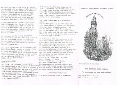
Document - THE BENDIGO POST OFFICE, 14/04/1995
Photographic display - The Bendigo Post Office 'A Landmark in the Landscape’ Dudley House - Bendigo. April 14 - 17, 1995. Also includes a Brief History of the Bendigo Post Office, Building Notes, Description, and the Post Office Clock has a small picture of the Post Office Clock on the front. From notes compiled by Mr. L. Bennetts. Bendigo Historical Society (Inc.) at the top of the front page.bendigo, institutions, bendigo post office, document, the bendigo post office, bendigo historical society (inc), dudley house bendigo, cenotaph, alexandra fountain, survey office, sandhurst trustees, post office savings bank, cohn family, temperance hall, telegraph office, railway station, 1882 directory, sub-treasury, sandhurst public offices, state government department offices, postal department, sir henry brougham lock, mr j nimmo, bendigo advertiser 25.9.1971, keen's cement, mr t gaunt melbourne, j w horwood's foundry castlemaine, w lowden, mr l bennetts -
 Melbourne Tram Museum
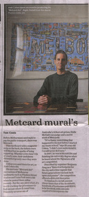
Newspaper, The Age, “Metcard mural's long and winding journey”, 17/04/2020 12:00:00 AM
Newspaper clippings titled: “Metcard mural's long and winding journey” by Tom Cowie Newspaper clipping from the Age 17/04/2020 Josh Cohen has created "Metcard Art", recreations of Melbourne's landmarks using Metcards. Metcards were sourced from personal collection, friends and eBay and artwork took 6 months to produce. Created for the Signature of M art competition in 2007.trams, tramways, metcard, melbourne, art -
 Wooragee Landcare Group
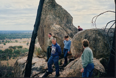
Photograph, circa April 2003
This photograph was taken in the Mount Pilot Chiltern National Park. It was taken during a search for the tiger quoll conducted by a team of volunteers from the Wooragee Landcare Group. The tiger quoll is also known as the spotted-tail quoll and is found in the national park. The 2003 bushfires caused worry for the safety of the tiger quoll, hence the need for a search for it. Mount Pilot Chiltern National Park is located near Chiltern in Victoria. It's most notable landmarks include Mt Pilot and Woolshed Falls. It also has many mines from the Gold Rush in the late 1800s. It is home to much flora and fauna, including the tiger quoll. The park is also home to the box-ironbark forest that once was present in most of north-eastern Victoria. The park is a large tourist destination as in there are many bushwalks and other attractions for visitors. In 2003, bushfires raged through Mount Pilot National Park and destroyed much of the environment. Some of this damage can be seen in the burnt trees in the picture. This photograph represents the work that goes into protecting a important species like the tiger quoll and there has been much work done to preserve it. This photograph was taken when the Wooragee Landcare group went to ensure the survival of this species, highlighting how the tiger quoll is being protected. This photograph also demonstrates the significance of Mount Pilot Chiltern National Park. The park has many special flora and fauna that can only be found in this area. For example, the box-ironbark forest and the tiger quoll. The forest used to stretch over much of north-eastern Victoria and is therefore reminiscent of what that area of Victoria was once like. This park is historical for this reason but it is also historical through it being once goldfields from the Gold Rush in the 1800s.Landscape coloured photograph printed on gloss paperReverse: WAN NA 0ANA2N0 NNN- 1 1636 / [PRINTED] (No.8) / 922mount pilot, mount pilot chiltern national park, chiltern, victoria, landmark, woolshed falls, gold rush, tiger quoll, flora, fauna, spotted tail quoll, marsupial, andy murray, andy murray quolls, carnivorous marsupial, forests, rainforests, coastal heathlands, woodlands, photograph, species, wooragee, wooragee landcare group, wooragee landcare, bushfires, identification, search, dna, droppings, box ironbark forest, ironbark, box iron bark -
 Wodonga & District Historical Society Inc
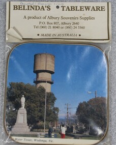
Memorabilia - Souvenir Coaster Woodland Grove Wodonga, Albury Souvenir Supplies, C. 1980s
A range of souvenirs depicting local landmarks were produced to represent and promote Wodonga and other towns throughout much of the 20th century. THE WATER TOWER is a major landmark of High Street, Wodonga. It began operation from 1924 until it ceased operation in 1959. It stood unused for a decade until the lower section was modified and put to use as “The Tower’s Cobbler’s Inn” in 1962. In 1972 Wodonga City Council proposed to demolish the Tower. Their suggestion received an unfavorable response from the city’s citizens, so the Tower still stands today. THE SOLDIERS' MEMORIAL in Wodonga was unveiled on Tuesday 18th November 1924. The soldier statue on the top has since been removed and placed in the RSL rooms, WodongaAn unopened packet containing a souvenir drink coaster representing Wodonga, Victoria. The coaster is a coloured photo of the Water Tower and Soldiers' Memorial in High Street, Wodonga.Beneath the photo "WATER TOWER, WODONGA, VICsouvenirs wodonga, water tower, memorials, woodland grove -
 Federation University Historical Collection
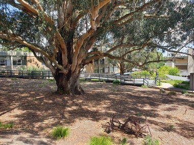
Photograph - Photograph - Colour, The Tree of Knowledge, 2020, 26/02/2020
The 'Tree of Knowledge' was planted on Arbor Day 1896 by Mrs Elizabeth Downing who lived on the farm that was originally the Mount Helen Site. When the site was purchased in 1966 the architects and planners inspected the site and decided 'The Big Tree' must remain as a central landmark in preparing the layout of the campus.Photograph of the 'Tree of Knowledge', a Tasmanian Blue Gum (Eucalyptus glubulus labillo), located at the Mount Helen Campus of Federation University. The tree is registered by the National Trust,federation university, federation university australia, feduni, university of ballarat, mount helen, tree of knowledge, big tree, blue gum, mount helen campus -
 Federation University Historical Collection
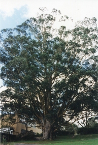
Photograph - Newsprint, The Tree of Knowledge, c2000, c2000
The 'Tree of Knowledge' was planted on Arbor Day 1896 by Mrs Elizabeth Downing who lived on the farm that was originally the Mount Helen Site. When the site was purchased in 1966 the architects and planners inspected the site and decided 'The Big Tree' must remain as a central landmark in preparing the layout of the campus.Photograph of the 'Tree of Knowledge', a Tasmanian Blue Gum (Eucalyptus glubulus labillo), located at the Mount Helen Campus of Federation University. The tree is registered by the National Trust,federation university, feduni, university of ballarat, mount helen, tree of knowledge, big tree, blue gum -
 Federation University Historical Collection
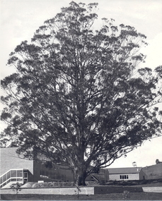
Photograph - Photograph - Black and White, The Tree of Knowledge, c1979, c1979
The 'Tree of Knowledge' was planted on Arbor Day 1896 by Mrs Elizabeth Downing who lived on the farm that was originally the Mount Helen Site. When the site was purchased in 1966 the architects and planners inspected the site and decided 'The Big Tree' must remain as a central landmark in preparing the layout of the campus.Photograph of the 'Tree of Knowledge', a Tasmanian Blue Gum (Eucalyptus glubulus labillo), located at the Mount Helen Campus of Federation University. The tree is registered by the National Trust,federation university, federation university australia, feduni, university of ballarat, mount helen, tree of knowledge, big tree, blue gum, mount helen campus -
 Bendigo Historical Society Inc.
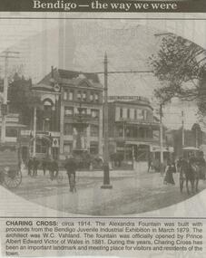
Newspaper - JENNY FOLEY COLLECTION: CHARING CROSS
Bendigo Advertiser ''The way we were'' from 2000. Charing cross: circa 1914. The Alexandra Fountain was built with proceeds from the Bendigo Juvenile Industrial Exhibition in March 1879. The architect was W.C. Vahland. The fountain was officially opened by Prince Albert Edward Victor of Wales in 1881. During the years, Charing Cross has been an important landmark and meeting place for visitors and residents of the town. The clip is in a building.newspaper, bendigo advertiser, the way we were -
 Bendigo Historical Society Inc.
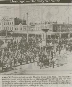
Newspaper - JENNY FOLEY COLLECTION: PARADE
Bendigo Advertiser ''The way we were'' from 2000. Parade: Sunday school parade, Charing Cross, circa 1900. The Alexandra Fountain stands at the intersection of Mitchell and View streets and Pall Mall and High street, formally known as Charing Cross. Charing Cross has been an important landmark and meeting place for visitors and residents of Bendigo and is a pick-up point for the talking tram tour. The clip is in a folder.newspaper, bendigo advertiser, the way we were -
 Bendigo Historical Society Inc.
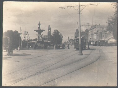
Photograph - WES HARRY COLLECTION: BENDIGO LANDMARKS, 1912
Group of four photographs of Bendigo Landmarks, Taken in 1912. (a) Fountain and Pall Mall, looking East, tram in the centre of the shot and the Hustlers Royal Reserve Poppet head visible to the left, (b) The law Courts with the Conservatory gardens in the foreground, (c) Statue in the Conservatory gardens, (d) shot taken from the tower of Camp Hill School, Rosalind park in the foreground, Post office and Law Courts middle distance.place, bendigo, landmarks, fountain, pall mall, hustlers royal reserve, the beehive, law courts, cons3erveratory gardens, setae, rosalind park -
Moorabbin Air Museum
Functional Object - Douglas DC-3 Instrument Panel
Historical Details: . Description: Even today, the DC3 is still the world’s most successful commercial aircraft ever with well over 10,000 examples being built. Known variously as the DC3, the C47 and the Dakota, this famous aircraft is a true landmark in aviation history. This DC-3/C-4. Level of Importance: -
 Federation University Historical Collection
Plan, Station Reserve Bakery Hill, Ballaarat
.1) Oversized photocopy of large plan depicting railway right of way where Mair and Humffray Streets meet. Main landmarks include Duke of Richmond Hotel, Prince of Wales Hotel, Duke of York Hotel, Welcome Nugget Claim and Shaft, Imperial Hotel, Union Hotel, Kingston St, Otway St, Wellington Claim, Gravel Pits Gold Working and Robert Burns Hotel. .2) Same of above. station reserve, bakery hill, railway, ballarat, mair street, humffray street north, duke of york hotel, duke of richmond hotel, union hotel, kingston st, otway st, wellington claim, gravel pits, gold workings, robert burns hotel -
 Bendigo Historical Society Inc.
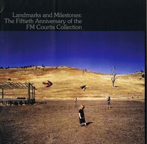
Book - LA TROBE UNIVERSITY BENDIGO COLLECTION: LANDMARKS AND MILESTONES:THE FIFTIETH ANNIVERSARY OF THE FM
Two copies of the booklet titled "Landmarks and Milestones: The Fiftieth Anniversary of the FM Courtis Collection". Bendigo Art Gallery 5 July - 10 August 2008. Education Faculty Bendigo, La Trobe Universiy Edwards Road, Flora Hill, Victoria 3550, Australia. Published 2008. On the front of the booklet is a photo of an outdoor scene with children flying kites. Within the book is a type written article describing the art collection.bendigo, education, bendigo teachers' college, la trobe university bendigo collection, collection, art collection, person, male, individual, fm courtis collection, bendigo art gallery, art works, artist, catalogue, art catalogue, exhibition, art education, art history, landscapes, mr. f. m. courtis -
 Bayside Gallery - Bayside City Council Art & Heritage Collection
Photograph, Department of Crown Lands and Survey, Victoria, Brighton, Elwood and Elsternwick, c. 1965-71
The Department of Crown Lands and Survey (1857-1983) was responsible for the administration of survey and mapping and the sale, occupation and management of crown land throughout its existence. This aerial photograph shows parts of Brighton, Elwood and Elsternwick and was taken circa 1965-71.brighton, department of crown lands and survey, aerial photograph, bayside, port phillip bay, map, cartographic material, elwood, elsternwick, elsternwick park, elwood tram depot, elwood pier, new street, glen huntly road, st kilda street, nepean highway -
Glen Eira Historical Society
Plan - Nettalie
An A4 photocopy of the 'Plan of the Caulfield Road District' dated 1867. This plan shows the location of the properties owned by A Shaw and Blundell on Balaclava and Orrong Roads where Nettalie is situated. The plan includes all the landowners listed where their property was, the street names and other landmarks of 1867 including railways, hotels and reserves.caulfield, caulfield north, elsternwick, st kilda east, parish of prahran, parish of moorabbin, caulfield road district, melbourne and brighton railway, rosstown railway, elsternwick railway station, caulfield railway station, rosstown railway station, murrumbeena railway station, baptist church, paddy’s swamp reserve, cemetery reserve, leman swamp reserve, caulfield racecourse reserve, brighton cemetery, the vine caulfield hotel, the tam o’shanter hotel, melbourne hunt hotel, royal hotel, hotham street, horne street, nepean highway, north road, orrong road, dandenong road, princes highway, kooyong road, alma road, inkerman road, balaclava road, glen eira road, glen huntly road, hawthorn road, cemetery road, bambra road, redan road, kambrook road, neerim road, booran road, racecourse road, grange road, koornang road, murrumbeena road, crosbie road, kangaroo road, poath road, ford w, lempriere, cople j, riddell j c, manifold j, testar t, billing r h, semple, blundell, shaw a, butchart g, stephen j w, stephen g sir, hart j, duncan g, blackie r, stephen f, mccombie t, woollaston h, higgins j, lloyd j c, daish j, mcleod j, hughes d, wilson a, jamieson g, webb g h, renwick s, pennington h, dunn j, kirkpatrick w, ricketson w, toad a, sayce j, watts t, widgery, store, guess j, anketell j, clack j, sissen w, clayton g, dickson d, bevan j, hart t, anderson j, hart mrs, webb h, masters s, waghorn j, hemming c, hiam c, farquhar w, newing t, payne t, cooper r, snipe s, chambers j, forster w, summers r, harriman b, warrick, o’connell, long j, peck r, cochrane c, murray ross w, evans c, kennedy j, maclean n, forster, lyall w, dean j, newton h, looker w, baker c, johnston, crosbie j, kerr, jones, parr, nelson c, montgomery l, parsons w, james j c, sibon c, smith sydney w, plans, maps, land subdivisions, land use, settlements, roads and streets, hotels, churches, police stations, post offices, land surveys, railway stations, railways, schoolhouses, commerce, clergy residences, official buildings, local government, road districts -
 Sunbury Family History and Heritage Society Inc.
Photograph, Bulla P, 1988
The photograph was taken from the west side of Bulla Hill near Loemans Road, which is west of the township of Bulla. The rocks outlining the name of the town were a landmark when approaching the township along the Sunbury Road on the west side of the town. They remained there until the school was closed in 1996 and the new owner removed them.A coloured photograph of Bulla Primary School with the word 'Bulla' formed from rocks on the distant hillside. schools, bulla primary school -
 Melbourne Tram Museum
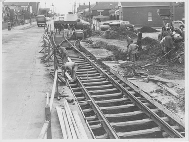
Photograph - Track laying Nicholson St and Holden St, 1956
Photograph shows construction of new track including a turnout to the right. While no notes are attached, landmarks indicate the photograph is of Nicholson St, North Fitzroy looking northward over Holden St/Brunswick Rd with a track connection to the remaining single track in those streets. This line was constructed in 1956 to replace the bus service.Yields information about construction of Bourke st electric line Black and white photograph with blue biro measurements on rearHandwritten notes read: '16, 8 2/16 x 6 1/8'm&mtb, track laying, nicholson st, east brunswick, holden st -
 Ringwood and District Historical Society
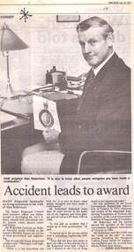
Newspaper, Scrapbook Clipping, Library Collection, Ringwood, Victoria
Newspaper Clipping from "The Mail", 22 June 1993, Page 8, "Accident leads to award". Article written by Jodie HaythorneMany Ringwood landmarks are living testaments to the work of Alan Robertson.The former Ringwood Council chief executive officer was instrumental in developing the city's library, cultural and convention centre, aquatic centre, district centre and bypass. Mr Robertson received an Order of Australia medal (OAM) in the Queen's Birthday honors for service to local government and engineering. -
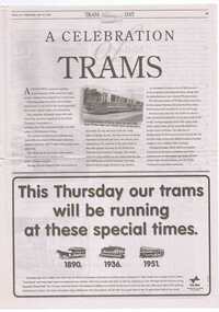 Ballarat Tramway Museum
Newspaper, Herald Sun, "A celebration of trams", 19/04/1995 12:00:00 AM
Pages 45 to 48 (with 37 to 40) of the Herald Sun Newspaper, Wed. 19/4/95, back grounding the cavalcade of Melbourne trams on 20/4/95 in Swanston St. to celebrate 70 years since electrification of Swanston St. Includes photos, notes, advertisements and an article by Keith Dunstan. "Our Landmark on Wheels". Photo caption of HTT No. 8, refers to Ballarat and Bendigo. Image of item added 2/11/13.trams, tramways, melbourne trams, tram day, swanston st. -
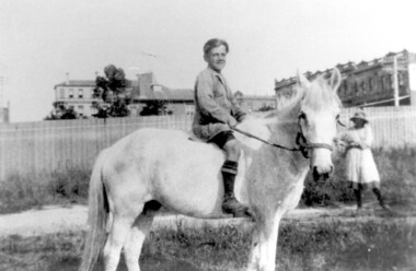 Surrey Hills Historical Society Collection
Photograph, Bill Willaton on one of Tacey's butcher's shop delivery horses, c 1920, 1920
The date is approximate. Bill Willaton was a driver for C E Gray & Son, bakers of Canterbury during the 1930s. Tacey's butcher shop (dem) was located at 629 Canterbury Road. Black and white photo of a young boy on a light-coloured horse in vacant land adjacent to Canterbury Road, Surrey Hills. In the background a girl is standing in front of a new-looking paling fence behind which can be seen local landmarks. On the right is Hansen's Terrace; on the far left part of the Surrey Hall can be seen and in the middle ground the rear of McNeill's Family Hotel (Surrey Lodge), Dartnell's corner and the side of the post office.tacey's butchers, horse-driven vehicles, hansen's terrace, surrey hills post office, surrey lodge, mcneill's family hotel, surrey hall, william willaton, bill willaton, surrey hills, canterbury road -
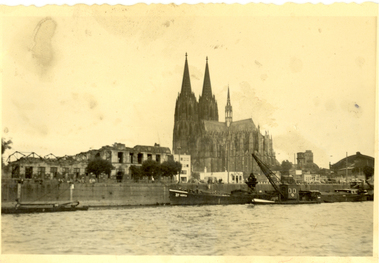 Federation University Historical Collection
Photograph - black and white, Cologne Cathedral from the Rhine, c1950
Cologne Cathedral is a renowned monument of German Catholicism and Gothic architecture and is a World Heritage Site. It is Germany's most visited landmark, attracting an average of 20,000 people a day. (Wikipedia) Though not targeted itself, the cathedral was very near to the central railway station and suffered fourteen hits by aerial bombs during World War II. Badly damaged, it nevertheless remained standing in an otherwise completely flattened city. The twin spires were an easily recognizable navigational landmark for Allied aircraft bombing deeper into Germany, which may explain why the cathedral was spared. Repairs were completed in 1956. An emergency repair on the northwest tower's base carried out in 1944 using poor-quality brick taken from a nearby ruined building remained visible until 2005 as a reminder of the war, when it was decided to restore the section its original appearance. (Wikipedia) Black and white photograph showing a grand cathedral from a waterway. It is Cologne (Koln) Cathedral from the Rhine. To the left of the photo bombed buildings are evident. The photograph is believed to have been taken by Frank Wright.cologne cathedral, koln, germany, rhine, bombing, world war two, frank wright -
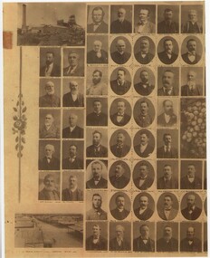 Rutherglen Historical Society
Image, c1880-1890
Copy of a photograph of early pioneers of Rutherglen. Copy has been made in two sections. The original featured a bunch of grapes in the centre with individual photographs, grouped about the centre. Photographs of each individual are identified with their name below the image. Photos of local landmarks are at each corner: top left - Great Southern Mine, top right - Town Hall, bottom left - Main Street-Looking West, bottom right - Main Street-Looking East.rutherglen, rutherglen pioneers -
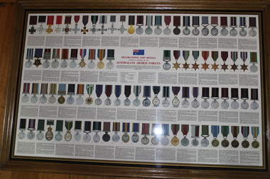 Lara RSL Sub Branch
Photograph, Decorations and Medals of The Australian Armed Forces, 1985
Over 1,400,000 Australians have served in times of conflict, from the Boer War to Afghanistan. Receiving awards on recognition of their service, some Australians have earned prestigious awards for their valour and gallantry. These are soldiers that have overwhelmed their opponents. They've gone over the wall or held the line, at huge personal cost. They've contributed to landmark events that history will long remember.The Australian Defence Medal (ADM) has been established to recognise Australian Defence Force Regular and Reserve personnel who have demonstrated their commitment and contribution to the nation by serving for an initial enlistment period or four years service whichever is the lesser.Rectangular shaped glass covered Picture frame showing Decorations and Medals of The Australian Armed Forces.Decorations and Medals awarded to members of the Australian Armed Forces -
 Victorian Interpretive Projects Inc.
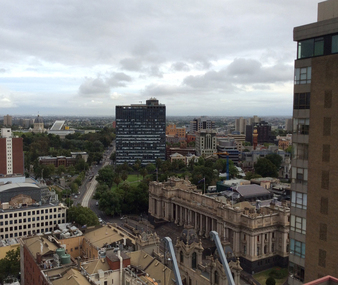
Photograph - Colour, Ann Gervasoni, Melbourne Towards Parliament House, 2015, 04/02/2015
Spring Street is culturally important to Victoria and is associated with the central spine of the administration of the Government of Victoria, as well as being central to many of the state's major cultural institutions. It is also notable for its Victorian architecture including the landmarks Victorian Parliament House, the Old Treasury Building, the Windsor Hotel (also known as Duchess of Spring Street) and the Princess Theatre. (Wikipedia)A colour photograph of Melbourne taken from above, showing Parliament House is Spring Street, with Russell Street in the midground. melbourne, spring street, victorian partliament house, windsor hotel, russell street -
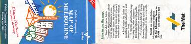 Melbourne Tram Museum
Map, Public Transport Corporation (PTC), "Public Transport Map of Melbourne", 5/1995
Map Includes description of tram and bus routes, private bus routes, and rail lines. Has contact details for bookings and lost property etc and how to use the map. Gives details of the ticketing system, along with photographs of the various modes. Dated May 1995 with a stylised image of some of Melbourne's landmarks on the cover. Published by the Public Transport Corporation.Yields information about Melbourne public transport services in 1995.Fold out map (36 sections 9 across x 4 deep), "Public Transport Map", coloured of Melbourne's Tram and Bus routes, route numbers, rail lines, detailed for the central part of Melbourne and the outer Metropolitan services.tramways, melbourne, tram services, bus services, maps, railways -
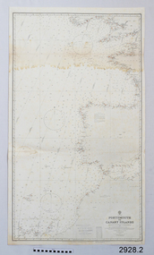 Flagstaff Hill Maritime Museum and Village
Document - Navigation Chart, Portsmouth to Canary Islands, CA. 1928
Navigation charts are drawn by professional hydrographers and describe the geography of land and water, enabling a water based navigator on board vessels such as ships to safely negotiate between ports locally and around the world. They are drawn to a particular standard with common symbols noting landmarks. The charts are used in conjunction with other navigational instruments and tools to calculate the vessel’s exact location and a safe route to its destination.The set of charts and their chart are of significance as examples of equipment and documents used to navigate the oceans of the world, particularly to Australia. Migration to Australia is an important part of this country's history.British Admiralty Navigation Chart - Portsmouth to Canary Islands - printed on rectangular white paper. Published in London by the British Admiralty in 1928.warrnambool, shipwreck coast, flagstaff hill, flagstaff hill maritime museum, flagstaff hill maritime village, chart, map, navigate, navigation, location, vessel, 1928, british admiralty, hydrographer, geography, admiralty chart, portsmouth, canary islands -
 Bayside Gallery - Bayside City Council Art & Heritage Collection
Photograph, Department of Crown Lands and Survey, Victoria, Melbourne Project: Brighton, 1976
The Department of Crown Lands and Survey (1857-1983) was responsible for the administration of survey and mapping and the sale, occupation and management of crown land throughout its existence. This aerial photograph shows parts of Brighton and was taken on 1 December 1976brighton, department of crown lands and survey, aerial photograph, bayside, port phillip bay, map, cartographic material, melbourne project 1976, brighton yacht club, middle brighton baths, north road, st kilda street, new street