Showing 461 items matching "lands, victoria"
-
 Bendigo Historical Society Inc.
Map - CAMPBELL COLLECTION: BENDIGO & DISTRICT MAPS
... lands Map. Bendigo Whipstick, Scale 40 chains to 1 inch, Forests Commission Victoria, map N0.3, legend for roads and land and forest. ...Map. Bendigo Whipstick, Scale 40 chains to 1 inch, Forests Commission Victoria, map N0.3, legend for roads and land and forest. (number 371 in map cupboard 1)map, bendigo, country lands -
 Bendigo Historical Society Inc.
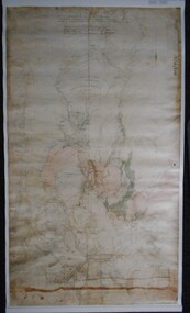
Map - PLAN GENERAL SURVEY MALMSBURY PORCUPINE INN, FOREST CREEK TO GOLDEN POINT. ALEXANDRA RANGE 1853
... lands R. Hoddle Colour Copy of Plan of the General Survey from the Town of Malmsbury to the Porcupine Inn, from the sources of Forest Creek to Golden Point, shewing (sic) the Alexandrian Range also Sawpit Gully Bendigo and Bullock Creeks. Handwritten note under the title a follows '' Forwarded to the Colonial Secretary with my letter No A 53/105 dated 30th March 1853 for transmission to the Geological Surveyor. R Hoddle Surveyor General. ' Stamped by Department of Mines Victoria ...Colour Copy of Plan of the General Survey from the Town of Malmsbury to the Porcupine Inn, from the sources of Forest Creek to Golden Point, shewing (sic) the Alexandrian Range also Sawpit Gully Bendigo and Bullock Creeks. Handwritten note under the title a follows '' Forwarded to the Colonial Secretary with my letter No A 53/105 dated 30th March 1853 for transmission to the Geological Surveyor. R Hoddle Surveyor General. ' Stamped by Department of Mines Victoria with record#123 in Top right Hand corner. Also contains a catalogue number 2053/M/2. Part of the Contents of a DVD entitled 'Mapping Great Change' - Archival Maps, produced to support an exhibition in the Post Office Gallery Bendigo. A description of the Map, its history and implications for both historical and future discussions is contained in an Essay 'Mapping Great Changes' : The landscape of central Victoria by Gerry Gill.R. Hoddlemap, bendigo, country lands -
 Bendigo Historical Society Inc.
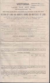
Document - KELLY AND ALLSOP COLLECTION: VICTORIA LAND TAX ACT 1910 - FORM, 31/12/1910 to 01/03/1911
... Victoria 1910. 'Return of Land and Monies Owing on Mortgage of Land.' Each form partly filled out by Arthur Allsop in pencil, ie 'Particulars of Land' section. He owns two houses in Wills St and a vacant block of land at Pyke/Brodie Streets. Instructions to taxpayers 'Every owner of land must furnish a return before 1st March 1911 of all lands...Victoria 1910. 'Return of Land and Monies Owing on Mortgage of Land.' Each form partly filled out by Arthur Allsop in pencil, ie 'Particulars of Land' section. He owns two houses in Wills St and a vacant block of land at Pyke/Brodie Streets. Instructions to taxpayers 'Every owner of land must furnish a return before 1st March 1911 of all lands ...Document. KELLY & ALLSOP COLLECTION. Three copies of Schedule B of Land Tax Act of Victoria 1910. 'Return of Land and Monies Owing on Mortgage of Land.' Each form partly filled out by Arthur Allsop in pencil, ie 'Particulars of Land' section. He owns two houses in Wills St and a vacant block of land at Pyke/Brodie Streets. Instructions to taxpayers 'Every owner of land must furnish a return before 1st March 1911 of all lands owned on 31 Dec 1910.'Taxation Office of Victoriabusiness, stockbroker, kelly & allsop, kelly & allsop collection, victoria land tax act 1910, schedule b -
 Bendigo Historical Society Inc.
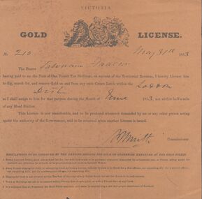
Document - MINER'S RIGHT - GOLD LICENSE NO 210 MINER'S RIGHT NO 20
... Lands within the Loddon District. At the bottom of the license are five Regulations to be observed by the person digging for gold or otherwise employed at the Gold Diggings. It has a crest at the top with a lion and a unicorn. Printed on a circular cnetre piece are the words: Honi so- -al y pense and below the lion, Dieu, in the centre is -t mon and under the unicorn is droit. The Miner's Right No 20, issued by the Colony of Victoria...Lands within the Loddon District. At the bottom of the license are five Regulations to be observed by the person digging for gold or otherwise employed at the Gold Diggings. It has a crest at the top with a lion and a unicorn. Printed on a circular cnetre piece are the words: Honi so- -al y pense and below the lion, Dieu, in the centre is -t mon and under the unicorn is droit. The Miner's Right No 20, issued by the Colony of Victoria ...Two licences, yellow-brown Victorian Gold License No 210, dated May 31, 1853 (a) and a Miner's Right No 20, dated 28 June 1861(b). The Gold License cost one pound ten shillings and for the month of June 1853. It was for Crown Lands within the Loddon District. At the bottom of the license are five Regulations to be observed by the person digging for gold or otherwise employed at the Gold Diggings. It has a crest at the top with a lion and a unicorn. Printed on a circular cnetre piece are the words: Honi so- -al y pense and below the lion, Dieu, in the centre is -t mon and under the unicorn is droit. The Miner's Right No 20, issued by the Colony of Victoria, for the District of Maldon, cost one pound. Across the top is a crest with a lion and a unicorn holding up an oval piece with a crown and a lion on top, In the oval is an illustration with two men and a woman and sailing ships in the background. Around the top of the oval is: Moni s- - qui mal y pense and at the bottom: Advance - Australia. Under the lion is: Dieu et mon and under the unicorn: Droit. Has been stamped in black, but is unreadable. Signatures and names on both documents are very hard to read. Printed by: John Ferres, Government Printer, Melbourne.document, gold, miner's right, miner's right, gold license no 210 & miner's right no20, john ferres -
 Bendigo Historical Society Inc.
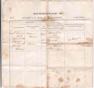
Document - DEATH CERTIFICATE OF THOMAS MORAN
... Victoria. Date of copy 19 February 1885. Signed by H.R.Hyde, Deputy Registrar, Raywood. On the rear: Noted in Lands Department, Chas A Roberts, 25/2/1885. ...Victoria. Date of copy 19 February 1885. Signed by H.R.Hyde, Deputy Registrar, Raywood. On the rear: Noted in Lands Department, Chas A Roberts, 25/2/1885. ...Certified copy of the registration of the death and burial Thomas Moran, miner. District of Raywood, Colony of Victoria. Date of copy 19 February 1885. Signed by H.R.Hyde, Deputy Registrar, Raywood. On the rear: Noted in Lands Department, Chas A Roberts, 25/2/1885. Death of Thomas Moran - 6 February 1882 at Inglewood Hill, Raywood Borough, County of Bendigo. Male aged 61 years. Cause of death: bronchitis and asthma. Duration of last illness: 2 years. Medical attendant by whom certified: P.H. McGillivray M.R.C.S. Sandhurst. Last saw the deceased: 26 November 1881. Parents unknown. Informant: William English, son-in-law, Raywood . Deputy Registrar: H.R.Hyde. Date of registration: 7 February 1882. Buried Raywood Cemetery 7 February 1882. Undertaker: William English, Raywood. Minister/Witnesses: Dennis Fogarty, Daniel Ryan. Where born: Kilkenny Ireland, One year in NSW, 30 years in Victoria. Married Melbourne, age 34, to Mary Dundon. Issue: Mary 26 years and Catherine 25 yearsgenealogy, family, moran, thomas moran, raywood, inglewood hill, william english, h.r.hyde, daniel ryan, death certificate, raywood cemetery, denis fogarty, kilkenny ireland, p.h. mcgillivray -
 Bendigo Historical Society Inc.
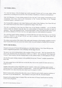
Document - VICTORIA HILL - VICTORIA HILL AND NEW CHUM HILL
... Victoria... Pioneer... Lansell 222 Mine... Lazarus... Barnet Lazarus... Mt. Alvernia Hospital... Fortuna Villa... George Lansell... A. H. Q. survey Regiment... Central Red White and Blue... Hudsons... Burrowes & Sterry... B C V Channel 8... Bendigo and District Tourist Association... Section 14 of the Lands...Victoria Pioneer Lansell 222 Mine Lazarus Barnet Lazarus Mt. Alvernia Hospital Fortuna Villa George Lansell A. H. Q. survey Regiment Central Red White and Blue Hudsons Burrowes & Sterry B C V Channel 8 Bendigo and District Tourist Association Section 14 of the Lands Act 1958 Mr A R Richardson Cr T R Flood Tourist Association Typed notes on Victoria Hill and New Chum Hill. ...Typed notes on Victoria Hill and New Chum Hill. Notes give location, value of gold and plans for a mining museum.document, gold, victoria hill, victoria hill and new chum hill, john neil macartney, the age, the australasian, bendigo goldfields registry 1871, victoria reef quartz mine, north old chum, victoria consols, new chum and victoria, pioneer, lansell 222 mine, lazarus, barnet lazarus, mt. alvernia hospital, fortuna villa, george lansell, a. h. q. survey regiment, central red white and blue, hudsons, burrowes & sterry, b c v channel 8, bendigo and district tourist association, section 14 of the lands act 1958, mr a r richardson, cr t r flood, tourist association -
 Bendigo Historical Society Inc.
Document - LANDS OFFICE: SALE OF CROWN LANDS BY PUBLIC AUCTION, 25/5/1898 - 26/8/1915
... Lands Office Journal: green hard cover journal with brown spine and corners. LH page: lot, county, town or parish, section, allotment, extent, why not sold, upset price per acre, sold for per acre. RH page: value of improvements, name of purchaser, residence, deposit forfeited, total amount. Contains details of sales by public auction across Victoria ...Journal: green hard cover journal with brown spine and corners. LH page: lot, county, town or parish, section, allotment, extent, why not sold, upset price per acre, sold for per acre. RH page: value of improvements, name of purchaser, residence, deposit forfeited, total amount. Contains details of sales by public auction across Victoria.Lands Officecrown lands public auction, lands office, crown lands, public auction., sandhurst -
 Bendigo Historical Society Inc.
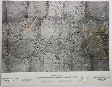
Map - FRED COWIE COLLECTION: AERIAL MAPS OF HEATHCOTE/EPPALOCK, 28-9-60
... Map, Heathcote C3, Aerial Survey of Victoria, Photo-map prepared by Department of Crown Lands and Survey from photographs taken in 1960.Copied photographically at the Central Plan Office. ...Map, Heathcote C3, Aerial Survey of Victoria, Photo-map prepared by Department of Crown Lands and Survey from photographs taken in 1960.Copied photographically at the Central Plan Office. ...Map, Heathcote C3, Aerial Survey of Victoria, Photo-map prepared by Department of Crown Lands and Survey from photographs taken in 1960.Copied photographically at the Central Plan Office. Date 28-9 60, C.P.O.Neg. No.21588.Campaspe River, Coliban River. Flower Hill. Fred Cowie,46 McIvor Rd.Bendigo (Not located 29.9.2022)Central Plan Office.map, heathcote, fred cowie -
 Bendigo Historical Society Inc.
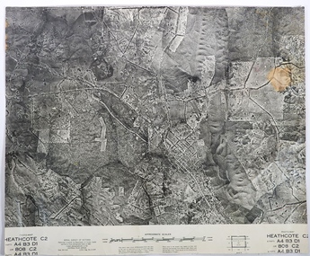
Map - FRED COWIE COLLECTION: AERIAL MAPS OF HEATHCOTE/EPPALOCK, 28-9-1960
... Aerial Survey of Victoria. Photo-map prepared by Department of Crown Lands and Survey from photographs taken in 1960. ...Aerial Survey of Victoria. Photo-map prepared by Department of Crown Lands and Survey from photographs taken in 1960. ...Map, Heathcote C2, Township of Heathcote, Melbourne Road through town branching off to Bendigo & Echuca. Aerial Survey of Victoria. Photo-map prepared by Department of Crown Lands and Survey from photographs taken in 1960. Copied photographically at the Central Plan Office.Fred Cowie,46 McIvor Rd,Bgo..Central Plan Officemap, heathcote, fred cowie -
 Bendigo Historical Society Inc.
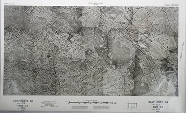
Map - FRED COWIE COLLECTION: AERIAL MAPS OF HEATHCOTE/EPPALOCK, 28-9-60
... Map, Heathcote C4, Aerial Survey of Victoria,Photo-map prepared by Department of Crown Lands and Survey from photographs taken in 1960. ...Map, Heathcote C4, Aerial Survey of Victoria,Photo-map prepared by Department of Crown Lands and Survey from photographs taken in 1960. ...Map, Heathcote C4, Aerial Survey of Victoria,Photo-map prepared by Department of Crown Lands and Survey from photographs taken in 1960. Copied photographically at the Central Plan Office.Date 28-9-60,C.P.O.Neg.No.21590.Scale 4 inches to 1 mile. Fred Cowie,46 McIvor Rd,Bgo..Central Plan Office.map, heathcote, fred cowie -
Bendigo Historical Society Inc.
Document - HARRY BIGGS COLLECTION: OLD POLICE BARRACKS, 5/6/70
... Biggs, Treasurer Royal Historical of Victoria (Bendigo Branch) dated 5th June 1970. In the letter he is stating The Depart. Of Crown Lands & Survey is investigating the future use & control of the old Police Barracks building....Biggs, Treasurer Royal Historical of Victoria (Bendigo Branch) dated 5th June 1970. In the letter he is stating The Depart. Of Crown Lands & Survey is investigating the future use & control of the old Police Barracks building. ...Document. Harry Biggs Collection. A letter on Public Works Department Victoria letterhead from G. Serpell Director General to Mr H. Biggs, Treasurer Royal Historical of Victoria (Bendigo Branch) dated 5th June 1970. In the letter he is stating The Depart. Of Crown Lands & Survey is investigating the future use & control of the old Police Barracks building.G. Serpell Director Generalorganization, club/society, community, harry biggs collection, old police barracks -
 Bendigo Historical Society Inc.
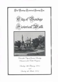
Book - CITY OF BENDIGO HISTORICAL WALK BOOK, 2001
... Prison Bendigo, Camp Hill Police Barracks, Sandhurst Corporate High School, Central State School No. 1976, The Cascades, District Lands Office (Dudley House), Masonic Temple and Hall, Sandhurst Volunteer Rifle Brigade Orderly Room, Bank of Victoria, Henry Jackson's Store View Point,Alexandra Fountain, Beehive Store/Mining Exchange, Colonial Bank. ...Prison Bendigo, Camp Hill Police Barracks, Sandhurst Corporate High School, Central State School No. 1976, The Cascades, District Lands Office (Dudley House), Masonic Temple and Hall, Sandhurst Volunteer Rifle Brigade Orderly Room, Bank of Victoria, Henry Jackson's Store View Point,Alexandra Fountain, Beehive Store/Mining Exchange, Colonial Bank. ...Photocopy mock up of original booklet of The Bendigo Historical Society Inc. 'City of Bendigo Historical Walk' containing photographs of historic buildings to be seen on the walk. Front cover Queen Victorian Gardens, Town hall, Mechanics Institute/School Of Mines and Industry, H. M. Prison Bendigo, Camp Hill Police Barracks, Sandhurst Corporate High School, Central State School No. 1976, The Cascades, District Lands Office (Dudley House), Masonic Temple and Hall, Sandhurst Volunteer Rifle Brigade Orderly Room, Bank of Victoria, Henry Jackson's Store View Point,Alexandra Fountain, Beehive Store/Mining Exchange, Colonial Bank. Hustlers Royal Reserve NO. 2/R.S.L. Memorial Hall, Post Office 3rd 4th and final, Bendigo Law Courts, Shamrock Hotel 2nd and another view. Important Bendigo Dates; 1851, April gold discovered at Golden Square by Margaret Kennedy,1851 Approx. 200,000Troy oz. of gold found in Bendigo, 1852 475,857 Troy oz. Gold for the year, 1853 November 31st Bendigo Hospital admits first patient,1853 December 9th Bendigo Advertiser first issue printed, 1854 First Land Sales and streets are surveyed and named for the first time, 1854 Census of Bendigo showed 15,480 residents plus 4,000 Chinese, 1855 Sandhurst Municipal District formed, 1861 Sandhurst Proclaimed a Town. 1862 Railway to Melbourne opened, 1867 Visit by His Royal Highness the Duke of Edinburgh, 1871 July 21st Sandhurst proclaimed a City, 1881 Population of Sandhurst 14,577 residents, 1882 First telephone communications introduced, 1890 Electric trams (battery) commenced running, 1891 May 18th City of Sandhurst changes its name to City of Bendigo.book, bendigo, buildings, historic -
 Bendigo Historical Society Inc.
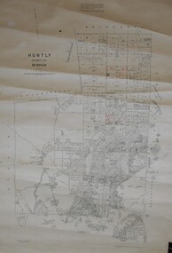
Map - JACK FLYNN COLLECTION: HUNTLY, August 1954
... Drawn and Reproduced at the Dept, of Lands and Survey, Melbourne, Victoria. August 1954....Drawn and Reproduced at the Dept, of Lands and Survey, Melbourne, Victoria. August 1954. Map: Parish of Huntly, County of Bendigo. ...Map: Parish of Huntly, County of Bendigo. Parish plan.By Authority W.M. Houston, Government Printer. Drawn and Reproduced at the Dept, of Lands and Survey, Melbourne, Victoria. August 1954.map, bendigo, parish plan, huntly -
 Bendigo Historical Society Inc.
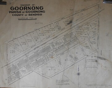
Map - JACK FLYNN COLLECTION: GOORNONG, August 1953
... Drawn and Reproduced at the Dept., of Lands and Survey, Melbourne, Victoria. August 1953...Drawn and Reproduced at the Dept., of Lands and Survey, Melbourne, Victoria. August 1953 Map: Township of Goornong, Parish of Goornong, County of Bendigo. ...Map: Township of Goornong, Parish of Goornong, County of Bendigo. Parish plan.By Authority W.M. Houston. Government Printer. Drawn and Reproduced at the Dept., of Lands and Survey, Melbourne, Victoria. August 1953map, bendigo, township, goornong -
 Bendigo Historical Society Inc.
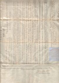
Document - TOWN LOT GRANT BY PURCHASE TO FREDERICK TAYLOR, 1854
... History House 11 Mackenzie Street Bendigo goldfields ORGANIZATION Lands and survey town lot grant purchase Town Lot Grant by Purchase to Frederick Taylor. Enrolled in the office of the registrar of the Supreme Court of the Colony of Victoria in Register, Town Purchases Victoria Folio 27 No. 27 this twenty-fifth day of September 1854. ...Town Lot Grant by Purchase to Frederick Taylor. Enrolled in the office of the registrar of the Supreme Court of the Colony of Victoria in Register, Town Purchases Victoria Folio 27 No. 27 this twenty-fifth day of September 1854. Colony of Victoria crest/seal. Witness our trusty and well beloved Sir Charles Hothamorganization, lands and survey, town lot grant purchase -
 Bendigo Historical Society Inc.
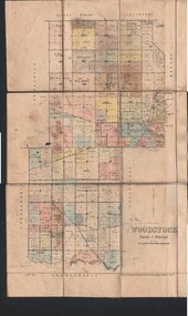
Map - JACK FLYNN COLLECTION: WOODSTOCK, 4/07/1935
... Drawn and Reproduced at the Dept of Lands and Survey, Melbourne Victoria. 4.7.35...Drawn and Reproduced at the Dept of Lands and Survey, Melbourne Victoria. 4.7.35 Map: Parish of Woodstock, County of Bendigo. ...Map: Parish of Woodstock, County of Bendigo. Parish plan.By Authority H.J. Green. Govt Printer. Drawn and Reproduced at the Dept of Lands and Survey, Melbourne Victoria. 4.7.35map, bendigo, parish plan, woodstock -
 Bendigo Historical Society Inc.
Document - LANDS OFFICE: CERTIFIED PLAN REGISTER
... Lands Office... Bendigo... plans... surveyed... Victoria...Dated 1878 - 1893, includes areas in central and northern Victoria. Document LANDS OFFICE: CERTIFIED PLAN REGISTER ...Document: hard cover journal. Buff cover with embossed edges. Spine has red insert with 'Certified Plan Register' printed in gold. 250 pages, with index in front of register. LH page: number, date of receipt, name, parish, tracing book, plan, decision of Board of land and works, gazette page, name of surveyors, date of survey, sent to, date. RH page: précis of minute. Dated 1878 - 1893, includes areas in central and northern Victoria.plan register, lands office, bendigo, plans, surveyed, victoria, northern victoria -
 Bendigo Historical Society Inc.
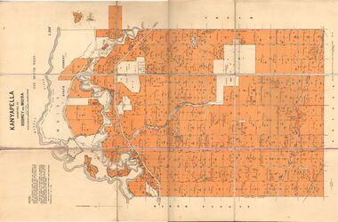
Map - JACK FLYNN COLLECTION: KANYAPELLA, 22/05/1939
... Drawn and Reproduced at the Dept. of Lands and Survey, Melbourne, Victoria....Drawn and Reproduced at the Dept. of Lands and Survey, Melbourne, Victoria. Map: Parish of Kanyapella, Counties of Rodney and Moira. ...Map: Parish of Kanyapella, Counties of Rodney and Moira. Parish plan.By Authority, T. Rider Acting Govt, Printer Melbourne. Drawn and Reproduced at the Dept. of Lands and Survey, Melbourne, Victoria.map, moira, parish plan, kanyapella, counties of rodney and moira -
 Bendigo Historical Society Inc.
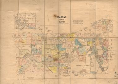
Map - JACK FLYNN COLLECTION: MARONG, June 1933
... Drawn and reporduced at the Dept., of Lands and Survey, Melbourne, Victoria....Drawn and reporduced at the Dept., of Lands and Survey, Melbourne, Victoria. Map: Parish of Marong, County of Bendigo. ...Map: Parish of Marong, County of Bendigo. Parish plan.By Authority W.M. Houston, Government Printer. Drawn and reporduced at the Dept., of Lands and Survey, Melbourne, Victoria.map, bendigo, parish plan, marong -
 Bendigo Historical Society Inc.
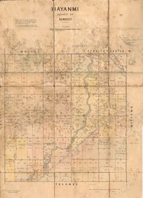
Map - JACK FLYNN COLLECTION: HAYANMI, March 1953
... Drawn and reproduced at the Dept, of Lands and Survey, Melbourne, Victoria...Drawn and reproduced at the Dept, of Lands and Survey, Melbourne, Victoria Map: Parish of Hayanmi, County of Bendigo. ...Map: Parish of Hayanmi, County of Bendigo. Parish plan.By Authority: W.M. Houston, Government Printer. Drawn and reproduced at the Dept, of Lands and Survey, Melbourne, Victoriamap, bendigo, parish plan, hayanmi -
 Bendigo Historical Society Inc.
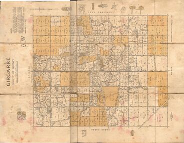
Map - JACK FLYNN COLLECTION: GIRGARRE, 14/10/1943
... Drawn and Reproduced at the Dept, of Lands and Survey, Melbourne, Victoria...Drawn and Reproduced at the Dept, of Lands and Survey, Melbourne, Victoria Map: Parish of Girgarre , County of Rodney. ...Map: Parish of Girgarre , County of Rodney. Parish plan. Same map as 10100.20 but in poorer condition.By Authority, H.E.Daw, Government printer Melbourne. Drawn and Reproduced at the Dept, of Lands and Survey, Melbourne, Victoriamap, rodney, girgarre, girgarre, county of rodney -
 Bendigo Historical Society Inc.
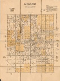
Map - JACK FLYNN COLLECTION: GIRGARRE, 14/10/1943
... Drawn and produced at the Dept of Lands and Survey, Melbourne, Victoria. 14.10.1943...Drawn and produced at the Dept of Lands and Survey, Melbourne, Victoria. 14.10.1943 Map: Parish of Girgarre. ...Map: Parish of Girgarre. County of Rodney. Parish plan.By Authority, H.E. Daw, Government Printer Melbourne. Drawn and produced at the Dept of Lands and Survey, Melbourne, Victoria. 14.10.1943map, rodney, parish plan, girgarre, county of rodney -
 Bendigo Historical Society Inc.
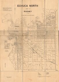
Map - JACK FLYNN COLLECTION: ECHUCA NORTH, November 1953
... Drawn and Reproduced at the Dept., of Lands and Survey Melbourne, Victoria. November 1953...Drawn and Reproduced at the Dept., of Lands and Survey Melbourne, Victoria. November 1953 Map: Echuca North, County of Rodney. ...Map: Echuca North, County of Rodney. Parish plan.By Authority: W.M. Houston, Government Printer. Drawn and Reproduced at the Dept., of Lands and Survey Melbourne, Victoria. November 1953map, rodney, parish plan, echuca north rodney -
 Bendigo Historical Society Inc.
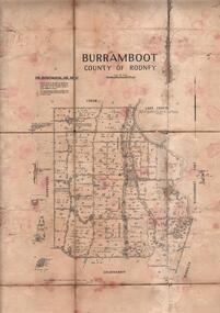
Map - JACK FLYNN COLLECTION: BURRUMBOOT, August 1951
... Drawn and Reproduced at the Dept of Lands and Survey, Melbourne, Victoria. August 1951...Drawn and Reproduced at the Dept of Lands and Survey, Melbourne, Victoria. August 1951 Map: Parish of Burrumboot, County of Rodney. ...Map: Parish of Burrumboot, County of Rodney. Parish plan.By Authority J.J. Gourley, Government Printer Melbourne. Drawn and Reproduced at the Dept of Lands and Survey, Melbourne, Victoria. August 1951map, rodney, parish plan, burrumboot, rodney -
 Bendigo Historical Society Inc.
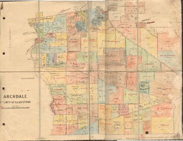
Map - JACK FLYNN COLLECTION: ARCHDALE, 15/01/1936
... Drawn and Reproduced at the Dept, of Lands and Survey, Melbourne, Victoria. 15/01/36...Drawn and Reproduced at the Dept, of Lands and Survey, Melbourne, Victoria. 15/01/36 Map: Parish of Archdale, County of Gladstone. ...Map: Parish of Archdale, County of Gladstone. Parish plan. The Allotments have been coloured in with pencil.By Authority H.J. Green, Government Printer Melbourne. Drawn and Reproduced at the Dept, of Lands and Survey, Melbourne, Victoria. 15/01/36map, gladstone, parish plan, archdale , gladstone -
 Bendigo Historical Society Inc.
Document - LANDS OFFICE: SALE OF CROWN LANDS
... Victoria Hard cover journal, green cover with buff spine and edges. Sticker on the front: Sale register 1934-1954. On the spine in red the number 16 and in black Land Sales 10-01-1934 to 31-12-1954. Pages entered with details of sales by public auction of crown lands ...Hard cover journal, green cover with buff spine and edges. Sticker on the front: Sale register 1934-1954. On the spine in red the number 16 and in black Land Sales 10-01-1934 to 31-12-1954. Pages entered with details of sales by public auction of crown lands. LH page: lot, county, town or parish, allotment, section, area, survey fee paid, upset price per lot, sold for per lot. RH page: value of improvements if any, name of purchaser, address, purchase money paid, grant fees and assurance paid.land sales, victoria, crown land sales, bendigo, central and northern victoria -
 Bendigo Historical Society Inc.
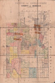
Map - JACK FLYNN COLLECTION: SHELBOURNE, 11/02/1937
... Drawn and Reproduced at the Dept, of Lands and Survey, Melbourne, Victoria....Drawn and Reproduced at the Dept, of Lands and Survey, Melbourne, Victoria. Map: Parish of Shelbourne, County of Bendigo. ...Map: Parish of Shelbourne, County of Bendigo. Parish plan.By Authority, H. J.Green, Government Printer. Drawn and Reproduced at the Dept, of Lands and Survey, Melbourne, Victoria.map, bendigo, parish plan, shelbourne -
 Bendigo Historical Society Inc.
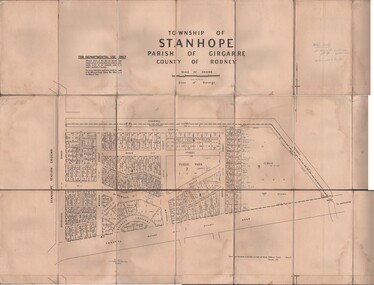
Map - JACK FLYNN COLLECTION: TOWNSHIP OF STANHOPE, December 1950
... Drawn and Reproduced at the Dept, of Lands and Survey, Melbourne, Victoria....Drawn and Reproduced at the Dept, of Lands and Survey, Melbourne, Victoria. Map: Township of Stanhope, Parish of Girgarre, County of Rodney. ...Map: Township of Stanhope, Parish of Girgarre, County of Rodney. Parish plan.By Authority J. J. Gourley, Government Printer, Melbourne. Drawn and Reproduced at the Dept, of Lands and Survey, Melbourne, Victoria.map, rodney, township, stanhope -
 Bendigo Historical Society Inc.
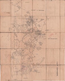
Map - JACK FLYNN COLLECTION: SANDHURST SHEET 6, January 1947
... Drawn and Reproduced at the Dept, of Lands and Survey, Melbourne, Victoria....Drawn and Reproduced at the Dept, of Lands and Survey, Melbourne, Victoria. Map: Parish of Sandhurst Sheet 6. ...Map: Parish of Sandhurst Sheet 6. County of Bendigo. Parish plan.By Authority J. J. Gourley, Government Printer, Melbourne. Drawn and Reproduced at the Dept, of Lands and Survey, Melbourne, Victoria.map, bendigo, parish plan, sandhurst sheet 6 -
 Bendigo Historical Society Inc.
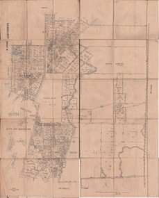
Map - JACK FLYNN COLLECTION: SANDHURST SHEET 2, January 1947
... Drawn and Reproduced at the Dept, of Lands and Survey, Melbourne, Victoria....Drawn and Reproduced at the Dept, of Lands and Survey, Melbourne, Victoria. Map: Parish of Sandhurst Sheet 2, County of Bendigo. ...Map: Parish of Sandhurst Sheet 2, County of Bendigo. Parish plan.By Authority J. J. Gourley, Government Printer, Melbourne. Drawn and Reproduced at the Dept, of Lands and Survey, Melbourne, Victoria.map, bendigo, parish plan, sandhurst sheet 2