Showing 183 items
matching mathers
-
 Federation University Historical Collection
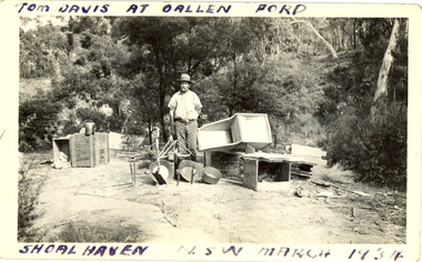
Photograph - Photograph - black and white, Oallen Ford and Shoalhaven River, 1934, 1934
Two black and white photographs associated with Donald Mather. .1) A man, Tom Davis stands surrounded with gold mining equipment such as gold pans, cradles, picks and buckets. He is at Oallen Ford on the Shoalhaven River, New South Wales .2) A man stands beside a ute with 2 women standing on the tray. The photo was taken after crossing a ford at Shoalhaven, New South Walesdonald mather, mather, shoalhaven river, mining, ute, utility, car, gold mining -
 Kew Historical Society Inc
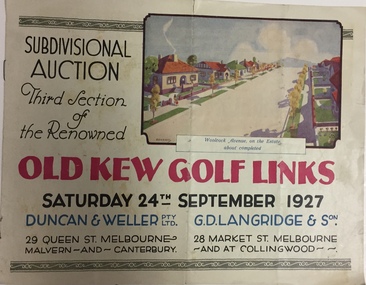
Booklet, Duncan & Weller Pty Ltd, Old Kew Golf Links Estate, 1927, 1927
The booklet advertises the third sale within the Old Golf Links Estate which was a major subdivision of farmland in North Kew in the 1920sThe subdivision of the Kew Golf Links Estate was a major subdivision of farmland in Kew. The site was at one stage designated for industrial development and the building of a new Kodak factory. The decision by Council to oppose the redevelopment makes the beginning of the period when all industrial development was banned in Kew.6 page illustrated brochure advertising the third section of a major subdivision in Kew in 1927 including 75 charming home allotments and 7 valuable building sites. The brochure includes the subdivision plan. The front cover includes a colour illustration of the almost completed houses in Woolcock Avenue. Streets named include: Kilby Road, Kodak Avenue, Baker Avenue, Mathers Avenue, Coleman Avenue, White Avenue and Belford Road. Lots for sale are numbered. Existing buildings are designated with a square.subdivisions - kew (vic), kew golf links estate -
 Dandenong/Cranbourne RSL Sub Branch
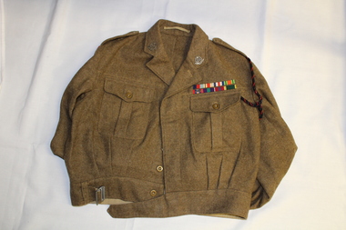
Army Uniform, Jacket made in 1950 and trousers made in 1954
WW2 Army uniform (jacket and trousers) belonging to 1494723 MAJ Derek MATHER, Royal Military Police. Campaign ribbons on left breast are: 1939-1945 Star, Africa Star, France and Germany Star, Defence Medal, War Medal 1939-1945 (Oak Leaf), General Service Medal 1918, Queen Elizabeth 2 Coronation Medal and the Efficiency Medal. Badge of the Royal Military Police on both lapels. Patch of the Cyrenaica District Middle East Land Forces on both shoulders. Lanyard of RMP on left shoulder.Army catalogue tags on both items -
 Kew Historical Society Inc
Photograph - Brick and Stucco Bungalow, J E Barnes, c.1920
The Kew Historical Society's map collection includes a substantial number of real estate subdivision plans, mainly of Kew but also of surrounding suburbs in Melbourne. Most of the subdivision plans date from the 1920s and 1930s when the districts old homes and local farmland were being split up to accommodate residential growth in the postwar period. These early plans were assembled by a local firm, Jas R Mather & McMillan, which had an office in Cotham Road. Many of the plans, and sometimes photos, were annotated by the agents.Subdivision plans are historically important documents used as evidence for the growth of suburbs in Australia. They frequently provide information about when the land was sold as well as evidence relating to surveyors and real estate and financial agents. The numerous subdivision plans in the Kew Historical Society's collection represent working documents, ranging from the initial sketches made in planning a subdivision to printed plans on which auctioneers or agents listed the prices for which individual lots were sold. In a number of cases, the reverse of a subdivision plan in the collection includes a photograph of a house that was also for sale by the agent. These photographs provide significant heritage information relating house design and decoration, fencing and household gardens.The photograph may also be aesthetically significant depending o the importance of the photographic atelier.Real estate photograph for a local agent by the Kew photographer, Josiah Earl Barnes. The photo is of a weatherboard or brick rendered bungalow with a twisted wire fence. Given Barnes' status a a Kew photographer, the house is probably locate din Kew or East Kew. Unfortunately the handwritten information on the mount bordering the photo is damaged and cannot be read. The bungalow has a gabled, tiled roof with terra cotta finials at the front of both gables. The house has a central doorway, framed by a pseudo portico supported by four wooden columns. On each side of the doorway, at the front, there are paired sash windows, which, like the half-timbered gable, are picked out in a darker colour.Handwritten, mostly illegible description by selling agent on mount surround: " .... in Diningroom, Drawing Rooms, ... Photographers details printed on mount: "J. E. Barnes / Photo / Phone 1966 Haw KEW"houses - kew, bungalows - kew, real estate photographs, j.e. barnes -- photographer -
 Kew Historical Society Inc
Photograph - Victorian Double-fronted Brock Villa, Cotham Road, c. 1919
The Kew Historical Society's map collection includes a substantial number of real estate subdivision plans, mainly of Kew but also of surrounding suburbs in Melbourne. Most of the subdivision plans date from the 1920s and 1930s when the districts old homes and local farmland were being split up to accommodate residential growth in the postwar period. These early plans were assembled by a local firm, Jas R Mather & McMillan, which had an office in Cotham Road. Many of the plans, and sometimes photos, were annotated by the agents.Subdivision plans are historically important documents used as evidence for the growth of suburbs in Australia. They frequently provide information about when the land was sold as well as evidence relating to surveyors and real estate and financial agents. The numerous subdivision plans in the Kew Historical Society's collection represent working documents, ranging from the initial sketches made in planning a subdivision to printed plans on which auctioneers or agents listed the prices for which individual lots were sold. In a number of cases, the reverse of a subdivision plan in the collection includes a photograph of a house that was also for sale by the agent. These photographs provide significant heritage information relating house design and decoration, fencing and household gardens.The photograph may also be aesthetically significant depending o the importance of the photographic atelier.Real estate photographs of a classic double-fronted late Victorian brick villa. It central location in Cotham Road, Kew enabled the selling agent to note its proximity to the tram. With seven rooms, all ‘modern conveniences’, and land of 66×167, the house was to be sold for £1100. The villa has a number of interesting features including a pattern within the slate roof as well as the use of polychrome brickwork under the eaves and on the façade. The intricacy of the cast iron lace is emphasised by the line of projecting wooden blocks above it. The picket gate is painted a different colour to the pickets of the fence. The house has a name (illegible) that is attached to the inset cast iron lace of the central projecting gable in the veranda. Stamped on mount: "Kew. Central. Close tram. / Comfortable Brick Villa. / Containing 7 rooms / Modern conveniences: / Land 66 x 167. Sold 1100 pounds:"houses - kew, victorian villas, real estate photographs, cotham road - kew -
 Kew Historical Society Inc
Photograph - Double-fronted Edwardian Villa, c.1918
The Kew Historical Society's map collection includes a substantial number of real estate subdivision plans, mainly of Kew but also of surrounding suburbs in Melbourne. Most of the subdivision plans date from the 1920s and 1930s when the districts old homes and local farmland were being split up to accommodate residential growth in the postwar period. These early plans were assembled by a local firm, Jas R Mather & McMillan, which had an office in Cotham Road. Many of the plans, and sometimes photos, were annotated by the agents.Subdivision plans are historically important documents used as evidence for the growth of suburbs in Australia. They frequently provide information about when the land was sold as well as evidence relating to surveyors and real estate and financial agents. The numerous subdivision plans in the Kew Historical Society's collection represent working documents, ranging from the initial sketches made in planning a subdivision to printed plans on which auctioneers or agents listed the prices for which individual lots were sold. In a number of cases, the reverse of a subdivision plan in the collection includes a photograph of a house that was also for sale by the agent. These photographs provide significant heritage information relating house design and decoration, fencing and household gardens.The photograph may also be aesthetically significant depending on the importance of the photographic atelier.On the reverse of a subdivision plan of the Palmyra Estate (Kew) is a photograph of a double-fronted Edwardian villa. The weatherboard and stucco house with high brick chimneys provides a clear indication of the style of curtains and gardens in houses of the period. Holland blinds with lace inserts are used in the left front window. They are combined with long lace curtains. The garden, with its curved pathway is bordered with garden beds that include marguerite daisies and roses. Reflecting a new interest in the Australian landscape, tree ferns and ground ferns are planted closer to the house.houses - kew, architecture - edwardian, real estate photographs -
 Kew Historical Society Inc
Photograph - Cottage, probably East Kew, A. Aberline, 1920s
The Kew Historical Society's map collection includes a substantial number of real estate subdivision plans, mainly of Kew but also of surrounding suburbs in Melbourne. Most of the subdivision plans date from the 1920s and 1930s when the districts old homes and local farmland were being split up to accommodate residential growth in the postwar period. These early plans were assembled by a local firm, Jas R Mather & McMillan, which had an office in Cotham Road. Many of the plans, and sometimes photos, were annotated by the agents.Subdivision plans are historically important documents used as evidence for the growth of suburbs in Australia. They frequently provide information about when the land was sold as well as evidence relating to surveyors and real estate and financial agents. The numerous subdivision plans in the Kew Historical Society's collection represent working documents, ranging from the initial sketches made in planning a subdivision to printed plans on which auctioneers or agents listed the prices for which individual lots were sold. In a number of cases, the reverse of a subdivision plan in the collection includes a photograph of a house that was also for sale by the agent. These photographs provide significant heritage information relating house design and decoration, fencing and household gardens.The photograph may also be aesthetically significant depending on the importance of the photographic atelier.An elevated, modest weatherboard house, photographed towards the end of the construction phase. The lower section of the weatherboards are exposed and stained. The upper section is rendered with rough-cast. The tiled roof has a single gable that extends over the centrally placed front porch. On the porch, the door and single sidelight are filled with coloured leadlight whereas the casement windows in the front rooms contain plain glass. The leadlight and the wrought iron of the verandah are the only decorative elements of the utilitarian design. The location of the house, which was advertised for sale, has not to date been identified. The real estate photograph is mounted on the reverse of a subdivision plan for the Harvest Home Estate, Kew East.Photographer's stamp, lower right on mount: "A. Aberline, Glenferrie"houses - kew, bungalows - kew, real estate photographs -
 Kew Historical Society Inc
Photograph - Bungalow, probably East Kew, 1920s
The Kew Historical Society's map collection includes a substantial number of real estate subdivision plans, mainly of Kew but also of surrounding suburbs in Melbourne. Most of the subdivision plans date from the 1920s and 1930s when the districts old homes and local farmland were being split up to accommodate residential growth in the postwar period. These early plans were assembled by a local firm, Jas R Mather & McMillan, which had an office in Cotham Road. Many of the plans, and sometimes photos, were annotated by the agents.Subdivision plans are historically important documents used as evidence for the growth of suburbs in Australia. They frequently provide information about when the land was sold as well as evidence relating to surveyors and real estate and financial agents. The numerous subdivision plans in the Kew Historical Society's collection represent working documents, ranging from the initial sketches made in planning a subdivision to printed plans on which auctioneers or agents listed the prices for which individual lots were sold. In a number of cases, the reverse of a subdivision plan in the collection includes a photograph of a house that was also for sale by the agent. These photographs provide significant heritage information relating house design and decoration, fencing and household gardens.The photograph may also be aesthetically significant depending on the importance of the photographic atelier.An unusual bungalow that does not conform to a particular architectural style but which contains eclectic elements of the style of varying periods. The most striking element of the design is the cantilevered veranda that is supported by heavy chains that are attached to the central gable. This deep gable extends across most of the façade, forming an extensive veranda. Parts of this are infilled with screens. Seven wooden posts, whose lower halves are encased in rendered brick pillars, support this gabled veranda. The roof would appear to be covered with corrugated iron. The location of the house, which was advertised for sale, has to date not been identified. The real estate photo is on the reverse of a plan for the Myrtle Hill Subdivision, Kew.bungalows - kew, architecture - 1920s, real estate photographs -
 Kew Historical Society Inc
Plan - Subdivision Plan, Argyle Road, Heather Grove, Victor Avenue, Kew, c.1937
The Kew Historical Society's map collection includes a substantial number of real estate subdivision plans, mainly of Kew but also of surrounding suburbs in Melbourne. Most of the subdivision plans date from the 1920s and 1930s when the districts old homes and local farmland were being split up to accommodate residential growth in the postwar period. These early plans were assembled by a local firm, Jas R Mather & McMillan, which had an office in Cotham Road. Many of the plans, and sometimes photos, were annotated by the agents.Subdivision plans are historically important documents used as evidence for the growth of suburbs in Australia. They frequently provide information about when the land was sold as well as evidence relating to surveyors and real estate and financial agents. The numerous subdivision plans in the Kew Historical Society's collection represent working documents, ranging from the initial sketches made in planning a subdivision to printed plans on which auctioneers or agents listed the prices for which individual lots were sold. In a number of cases, the reverse of a subdivision plan in the collection includes a photograph of a house that was also for sale by the agent. These photographs provide significant heritage information relating house design and decoration, fencing and household gardens.The photograph may also be aesthetically significant depending on the importance of the photographic atelier.Undated blue subdivision plan in Kew of 14 lots facing Argyle Road, Heather Grove and Victor Road. The Plan identifies Tuxen & Miller as the surveyors. [Formerly catalogued as MAP.0059]subdivision plans - kew, argyle road - kew, heather grove - kew, victor avenue - kew -
 Kew Historical Society Inc
Plan - Subdivision Plan, Kew Golf Links Estate, 1936, 1936
The Kew Golf Links Estate was a major subdivision in North Kew. It derived its title due to the land being previously occupied by the Kew Golf Club, which transferred its course to a number of locations before occupying its current site. The Plan advertises 180 choice home sites. The street names are somewhat different today as those on the map are named after the proposed Kodak Factory to be built on the site. The subdivision of the Kew Golf Links Estate was a major subdivision of farmland in Kew. The site was at one stage designated for industrial development and the building of a new Kodak factory. The decision by Council to oppose the redevelopment makes the beginning of the period when all industrial development was banned in Kew.Monochrome printed, folded subdivision plan for the Kew Golf Links Estate, to be auctioned on 7 November 1936. Streets named include: Carnegie Avenue, Willsmere Road, Kilby Boulevarde, Kodak Avenue, Coleman Avenue, Beresford Avenue, McConchie Avenue, Cole Avenue, White Avenue, Baker Avenue, Spruzen Avenue, Tanner Avenue, Ratten Avenue, Mathers Avenue, Railway Avenue, Sutherland Avenue, and Belford Road. The position of the Yarra River and a large Drainage Reserve are marked on the plan. Lots for sale are numbered. Existing buildings are designated with a square.subdivision plans - kew (vic), kodak factory - kew (vic) -
 Stawell Historical Society Inc
Photograph, Stawell High School Students1975, 1975
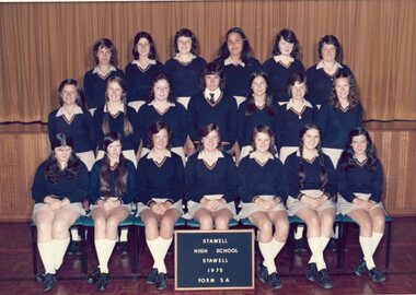
6975-36 Stawell High School Form 5A, 1975 Form Teacher Mrs Mather Back Row, Jilleen Jenkins, Paulett ?, Kaylene Clarke, Gaylene Slorach, Nancy Allan, Judy Kindred, Middle Row, Suzanne Gercovich, Pam Guy, Mary-anne Disher, Neville Moller, Ruth West, Gayle Redford, Elizabeth Klauss, Front Row, Jenny O'Neill, Karen Vendy, Pam Giles, Lynne Barney, Wendy Blake, Poppy Mangana, Angela Hayes, Absent, Bradley Mair, New, Bruce Johnston. Students Class Photo InteriorStawell High School 1975 Form 5Aeducation -
 Federation University Historical Collection
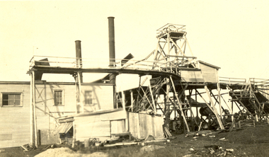
Photograph, Lal Lal Coal and Iron Mine, Victoria, 1923
Lal Lal Coal Mine, 1923. Two black and white photographs of the Lal Lal Coal Mine. .1) A man, Bill Thomas of Talbot, stands high on a timber construction. .2) A mine site with poppet head and two chimneys..1) verso: Lal Lal Coal and [Iron?] Mine 1,000 ton hopper or brown coal Designed and Built by D. Mather 1923 [15?] miles of sapplings in the building [Ci?] called and drying [oval] 120' long 45' x 20' wide Bill Thomas shown in this photo, from Talbot.lal lal, lal lal coal mine, donald mather, mather, bill thomas, talbot, mining -
 Federation University Historical Collection
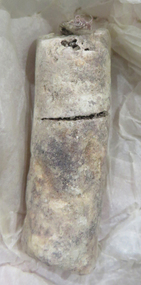
Object - Candle Remnant, Candle remnant from early Two Ballarat mines, c1860 ?
From the Britannia Mine (Ballarat) Candle remnants from early Ballarat mines are quite rare..1) White/cream candle remnant. Candle mold seams are evident. Stored in green pharmaceutical tin with screw lid. (?) Found when removing for filling motor spaces Camp Street. .2) white candle remnant from the Britannia Mine at Cambrian Hill held in a 'Barker Cake Container; tin. A handwritten note inside the tin indicates 'Piece of Candle from Mullock's Britannia Mine. Ballarat. .2) Piece of Candle The Great Leviathan Quartz Mining CosMine at Cambrian Hill near Ballarat. Picked up by Donald Doyles Mather whilst cleaning out Ballarat South Goldfield Co's Leviathan Shaft when reopening "Great Leviathan in in the year 1948. The candle was last used by miners in the Great Leviathan in the drive where found Year G. Leviathan Closed down "______" mining, candle, lard, great leviathan, donald mather, cambrian hill, great leviathan quartz mining company -
 Kew Historical Society Inc
Plan - Subdivision Plan, Old Kew Golf Links Estate - Third Section, 1920-1929
Pru Sanderson, in her groundbreaking ‘City of Kew Urban Conservation Study : Volume 2 - Development History’ (1988), summarised the periods of urban development and subdivisions of land in Kew. The periods that she identified included 1845-1880, 1880-1893, 1893-1921, 1921-1933, 1933-1943, and Post-War Development. These periods were selected as they represented periods of rapid growth or decline in urban development. An obvious starting point for Sanderson’s groupings involved population growth and the associated economic cycles. These cycles also highlighted urban expansion onto land that was predominantly rural, although in other cases it represented the decline and breakup of large estates. A number of the plans in the Kew Historical Society’s collection can also be found in other collections, such as those of the State Library of Victoria and the Boroondara Library Service. A number are however unique to the collection.The Kew Historical Society collection includes almost 100 subdivision plans pertaining to suburbs of the City of Melbourne. Most of these are of Kew, Kew East or Studley Park, although a smaller number are plans of Camberwell, Deepdene, Balwyn and Hawthorn. It is believed that the majority of the plans were gifted to the Society by persons connected with the real estate firm - J. R. Mathers and McMillan, 136 Cotham Road, Kew. The Plans in the collection are rarely in pristine form, being working plans on which the agent would write notes and record lots sold and the prices of these. The subdivision plans are historically significant examples of the growth of urban Melbourne from the beginning of the 20th Century up until the 1980s. A number of the plans are double-sided and often include a photograph on the reverse. A number of the latter are by noted photographers such as J.E. Barnes.When the old Kew Golf Links was subdivided in the mid 1920s, the developers were able to break the sale into sections. The third section included eighty lots. The lots faced Kilby Road, Kodak Avenue, Belford Road, Baker Avenue, Mathers Avenue, and White Avenue. [Kodak Avenue was renamed Page Avenue at a later date].The ‘Kew Conservation Study (1988) notes that ‘On the subdivision plan, Kodak’s involvement is commemorated by the naming of the streets after Company directors, and their decision to not proceed with the construction of the factory is explained as a response to the increase in the value of the land. This explanation may have been Estate Agent’s hyperbole, as the Kodak Company records suggest that the land, with its wide creek gully, was unsuitable and too small for its purposes.subdivision plans - kew, old kew golf links estate - third section -
 Lakes Entrance Historical Society
Photograph - Football, Lakes Post Newspaper, 1/05/1999 12:00:00 AM
Other number 03625.1Colour photograph of Lakes Entrance Football Club under 13 team with their officials Back Row: Geoff Ellis,Jake Rose,Chris Gordon,Jarrod Coad,Dane Rosenboom, Richard Bayard Rohan Sproule, Nathan Allen,Lou Battista (coach) Allen Rowlands (president) Middle Row: Brendon Matthews, Xavier Ellis, Michael Battista, Rhys Allitt, Rene Cerda, Damian Evans, Mitchell O'Donnell, Lachlan O'Donnell, Mark Rosenboom, Josh Kenny Front Row: Julio Cerda (manager) Adam Lowcock, Chris LeMaitre, Jamie Jenkins, Chris Mathers Jack Reggardo (assistant coach) Joel Waters, Gary Glew, Sean Sproule, Trevor Cordery (trainer), Lakes Entrance Victoriaclubs, football -
 Kew Historical Society Inc
Photograph - 'Mount Eri', 9 Highbury Grove, 1919
Subdivision plans are historically important documents used as evidence of the growth of suburbs in Australia. They frequently provide information about when the land was sold on which a built structure was subsequently constructed as well as evidence relating to surveyors and real estate and financial agents. The numerous subdivision plans in the Kew Historical Society's collection represent working documents, ranging from the initial sketches made in planning a subdivision to printed plans on which auctioneers or agents listed the prices for which individual lots were sold. In a number of cases, the reverse of a subdivision plan in the collection includes a photograph of a house that was also for sale by the agent. These photographs provide significant heritage information relating house design and decoration, fencing and household gardens.A photograph of Mount Eri, 9 Highbury Grove, an 11-room house for sale near the junction of Cotham and Glenferrie Roads. The substantial red brick, slate-roofed house and its location are not identified in the photograph, although the extent of the house is noted. It was described then as ‘well situated’ and close to 3 trams. Mathers, a financial agent in Cotham Road, placed advertisements about the sale of the property in The Argus in May and June 1919. The advertisement additionally refers to a billiard room and asserts that the house has every modern convenience. An annotation on the plan indicates that the house, with tennis court, was sold for £1960. Following extensive research, the house has now been conclusively identified, albeit extended and rendered. The house was originally built in the 19th century as a school and for much of the 20th century was used as a venue for receptions. -
 Bendigo Historical Society Inc.
Newspaper - JENNY FOLEY COLLECTION: FLAG BEARERS
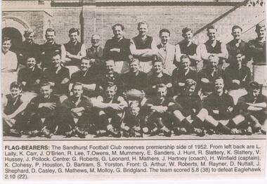
BHS CollectionBendigo Advertiser ''The way we were'' from 2003. Flag-bearers: the Sandhurst Football Club reserves premiership side of 1952. From left back are: L. Laity, K. Carr, J. O'Brien, R. Lee, T. Owens, M. Mummery, E. Sanders, J. Hunt, R. Slattery, K. Slattery, V. Hussey, J. Pollock. Centre: G. Roberts, G. Leonard, H. Mathers, J. Hartney (coach), H. Winfield (captain), k. Clohesy, P. Houston, D. Bartram, S. Yorston. Front: G. Arthur, W. Roberts, m. Rayner, D. Nuttall, J. Shephard, D. Casley, g. Mathews, M. Molloy, G. Bridgland. The team scored 5.8 (38) to defeat Eaglehawk 2.10 (22). The clip is in a folder.newspaper, bendigo advertiser, the way we were -
 Lakes Entrance Historical Society
Photograph - Football team, Bairnsdale Advitisor, 1/09/2003 12:00:00 AM
Other number 03640.3Colour photograph of Football Club Thirds Premiership team 2003, Back Row: Rhys Allitt, Michael Ballista, David Kelly, Xavier Ryan, Edward McKenzie, Chris Robertson, Xavier Ellis, Daniel Carsons, Ray Reggardo (trainer). Centre Row: Chris McKenzie,(trainer), Wayne Reggardo (president), Damien Cooper,(assistant coach), Luke Baldwin, Tom Bulmer, Michael O'Connell, Dean Cook, Owen Hensworth-Smith, Brad Hallyer, Daniel Machelin, Nathan Allen, Chris Bulmer, Geoff Ellis(trainer) Front Row: Joel Walker, Chance James, Brett Campise, Nathan Peglar (captain) Lou Battista)coach) Rene Cerda, Chris LeMaitre, Chris Mathers, Tom Cook (property steward), Nicholas Bulmer(mascot) Lakes Entrance Victoriaclubs, football -
 Kew Historical Society Inc
Plan - Subdivision Plan, Balwyn Theatre and Shop Sites, circa 1927-28, c.1927-28
The Kew Historical Society's map collection includes a substantial number of real estate subdivision plans, mainly of Kew but also of surrounding suburbs in Melbourne. Most of the subdivision plans date from the 1920s and 1930s when the districts old homes and local farmland were being split up to accommodate residential growth in the postwar period. These early plans were assembled by a local firm, Jas R Mather & McMillan, which had an office in Cotham Road. Many of the plans, and sometimes photos, were annotated by the agents. The ‘new’ Balwyn Picture Theatre was built and owned by Balwyn Theatres Pty Ltd in ca. 1928. By 1930, this first Balwyn Theatre was destroyed by fire after a break-in. Following the fire, a new cinema was constructed. This plan for a Cinema and eleven shops presumably dates from 1927/28 when the Company announced that this location in Whitehorse Road ‘was the most central and best suited [area] for their Theatre and shops’.Subdivision plans are historically important documents used as evidence for the growth of suburbs in Australia. They frequently provide information about when the land was sold as well as evidence relating to surveyors and real estate and financial agents. The numerous subdivision plans in the Kew Historical Society's collection represent working documents, ranging from the initial sketches made in planning a subdivision to printed plans on which auctioneers or agents listed the prices for which individual lots were sold. In a number of cases, the reverse of a subdivision plan in the collection includes a photograph of a house that was also for sale by the agent. These photographs provide significant heritage information relating house design and decoration, fencing and household gardens.The photograph may also be aesthetically significant depending on the importance of the photographic atelier.Subdivision plan showing the Balwyn Theatre and its adjoining shop sites in Whitehorse Road Balwyn. The 11 shop sites were noted for their depth (133 ft - 145 ft. [Map.0041]balwyn theatre -- balwyn (vic.), subdivisions -- balwyn (vic), subdivision plans -
 Victoria Police Museum
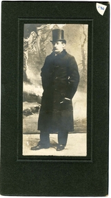
Photograph (Frederick Deeming)
In March 1892, Melbourne Butcher John Stamford took a prospective tenant to a house he owned at 57 Andrew Street Windsor. He noticed a 'disagreeable smell' coming from the front rooms. Suspecting foul play, Stamford called the police who quickly discovered a decomposing body and partially clad body of a young woman in a shallow grave under the fireplace. 'Her skull had been shattered and her throat cut'. Two detectives, Sergeants Considine and Cawsey, began investigations. The previous tenant, a 'Mr. Druin' who had rented the house had since disappeared was the main suspect. 'Druin' had arrived in Australia from England as 'Albert Williams' in December 1891 with his 24 year old wife Emily Mather. The body was Emily's. The crime scene investigation proved difficult as the suspect - whatever his real name- had cleaned up the scene very carefully. Much later it was discovered that the suspect was in fact Frederick Bayley Deeming, a former sailor born in Birkenhead, Cheshire, in 1854. In 1881, Deeming deserted his ship and lived in Sydney where he married and had a family. Deeply in debt, he later burned his business down to claim its insurance value and fled to South Africa before he could be arrested. He is believed to have committed numerous frauds and murders in Africa. Eventually found in Uruguay, he spent time in prison in England for fraud. After being released he married Emily and returned to Australia. After leaving England, British police began investigating him over the murder of Mrs Marie Deeming and her four children. Now using another alias, 'Baron Swanston', Deeming was arrested in Western Australia before he left the country in the company of a young woman, Kate Rounsefell, whom he planned to marry. It seems Kate would have been his next murder victim. Brought back to Victoria, in May 1892, Deeming went on trail for the murder of Emily Mather. Despite a strong defense conducted by a brilliant young barrister and 3 times Australian Prime Minister Alfred Deakin, the evidence against Deeming was overwhelming and he was found guilty. Deeming was hanged at Melbourne Gaol on 23 May 1892. He was known to be responsible for at least 6 murders and may have committed others. Black and white photograph backed onto black backing board showing a man in a long coat and top hat with his hands in his pockets and a moustachefrederick deeming, emily mather, murders -
 Victoria Police Museum
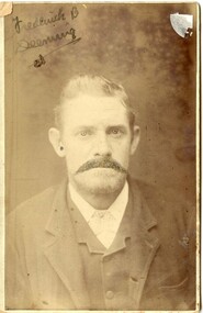
Photograph (Frederick Deeming)
In March 1892, Melbourne Butcher John Stamford took a prospective tenant to a house he owned at 57 Andrew Street Windsor. He noticed a 'disagreeable smell' coming from the front rooms. Suspecting foul play, Stamford called the police who quickly discovered a decomposing body and partially clad body of a young woman in a shallow grave under the fireplace. 'Her skull had been shattered and her throat cut'. Two detectives, Sergeants Considine and Cawsey, began investigations. The previous tenant, a 'Mr. Druin' who had rented the house had since disappeared was the main suspect. 'Druin' had arrived in Australia from England as 'Albert Williams' in December 1891 with his 24 year old wife Emily Mather. The body was Emily's. The crime scene investigation proved difficult as the suspect - whatever his real name- had cleaned up the scene very carefully. Much later it was discovered that the suspect was in fact Frederick Bayley Deeming, a former sailor born in Birkenhead, Cheshire, in 1854. In 1881, Deeming deserted his ship and lived in Sydney where he married and had a family. Deeply in debt, he later burned his business down to claim its insurance value and fled to South Africa before he could be arrested. He is believed to have committed numerous frauds and murders in Africa. Eventually found in Uruguay, he spent time in prison in England for fraud. After being released he married Emily and returned to Australia. After leaving England, British police began investigating him over the murder of Mrs Marie Deeming and her four children. Now using another alias, 'Baron Swanston', Deeming was arrested in Western Australia before he left the country in the company of a young woman, Kate Rounsefell, whom he planned to marry. It seems Kate would have been his next murder victim. Brought back to Victoria, in May 1892, Deeming went on trail for the murder of Emily Mather. Despite a strong defense conducted by a brilliant young barrister and 3 times Australian Prime Minister Alfred Deakin, the evidence against Deeming was overwhelming and he was found guilty. Deeming was hanged at Melbourne Gaol on 23 May 1892. He was known to be responsible for at least 6 murders and may have committed others. Medium sized photograph of Frederick Deeming with a moustache drawn on the image in inkFrederick B. Deeming (on image in black ink)frederick deeming, emily lydia mather, murders -
 Bendigo Historical Society Inc.
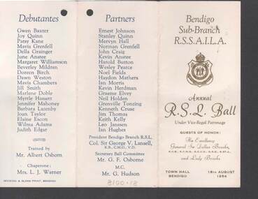
Document - R.S.L. BENDIGO COLLECTION: ANNUAL R.S.L. BALL 1954, 18th August, 1954
Two copies of the Bendigo Sub-branch R.S.S.A.I.L.A. Annual R.S.L. Ball held at the Town Hall, Bendigo on 18th August 1954. Guests of Honour were His Excellency General Sir Dallas Brooks, K.C.B., K.C.M.G., K.C.V.O., D.S.O., K.ST.J., and Lady Brooks. Card is cream with gold print on the front and a gold RLS badge. Other printing is blue. The inside of the tri-fold card has a Dance Program of 28 dances and a space for Autographs. The other side has the Debutantes: Gwen Baxter, Joy Quinn, Patsy Kane, Mavis Grenfell, Della Grainger, June Anstee, Margaret Williamson, Beverley Mildren, Doreen Birch, Dawn Weston, Mavis Chambers, Jill Smith, Marlene Doble, Myrtle Hassett, Jennifer Mahoney, Barbara Lazenby, Joan Taylor, Elaine Escon, Wilma Adams and Judith Edgar. Trained by Mr Albert Osborn. Chaperone: Mrs L J Warner. Partners: Ernest Johnson, Stanley Quinn, Mervyn Hall, Norman Grenfell, John Craig, Kevin Anstee, Harold Button, Wesley Pearce, Noel Fields, Haydon Mathers, Ian Morris, Kevin Herdman, Graeme Elvey, Neil Holden, Grenville Tonzing, Kenneth Cruse, Jim Thomas, Keith Kelly, Leo Janssen and Ian Hughes. President Bendigo Branch R.S.L: Col. Sir George Lansell, K.B., C.M.G., V.D. Secretary Ball Committee: Mr G F Osborne. M.C. Mr G Hudson. Printed by Hocking & Sloan Print, Bendigo.Hosking & Sloan Print, Bendigoevent, social, annual ball, r.s.l. bendigo collection - annual r.s.l. ball 1954, his excellency general sir dallas brooks, lady brooks, gwen baxter, joy quinn, patsy kane, mavis grenfell, della grainger, june anstee, margaret williamson, beverley mildren, doreen birch, dawn weston, mavis chambers, jill smith, marlene doble, myrtle hassett, jennifer mahoney, barbara lazenby, joan taylor, elaine escon, wilma adams, judith edgar, mr albert osborn, mrs l j warner, ernest johnson, stanley quinn, mervyn hall, norman grenfell, john craig, kevin anstee, harold button, wesley pearce, noel fields, haydon mathers, ian morris, kevin herdman, graeme elvey, neil holden, grenville tonzing, kenneth cruse, jim thomas, keith kelly, leo janssen, ian hughes, col sir george v lansell, mr g f osborne, mr g hudson -
 St Kilda Historical Society
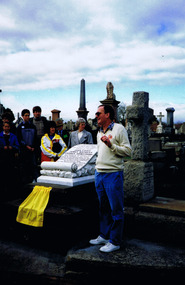
Photograph, 'Glen Huntley' Passengers Memorial Restoration 1992 - images collection, 1992
The memorial grave was dedicated on 16 April, 1899. Following the 150th anniversary of the arrival of the barque, descendants of John Craig and other "Glen Huntly" passengers restored the memorial. Descendants gathered in 1992 for the unveiling of a plaque marking the restoration.Colour photographRear of each photograph: SK Cemetery 1992 Glenhuntly Descendants. Inscription on memorial: On December 13th 1839, the emigrant ship "Glen Huntly" left Greenock, Scotland and arrived in Hobson`s Bay on 17th April 1840. Many of the passengers suffering from fever were landed at the Red Bluff St Kilda on 24th April 1849. That being the first quarantine station in Victoria. A few days later John Craig James Mathers George Armstrong succumbed to the disease and were interred at The Bluff. Owing to the encroachment of the sea their remains were exhumed and removed to the St Kilda Cemetery on 27th August 1898 by the Board of Public Health.This memorial was erected by public subscription, to mark a notable event in the early history of the colony. Inscription on plaque, unveiled in 1992: This memorial grave was restored by descendants of John Craig and of other "Glen Huntly" passengers. In April 1990 they commemorated the 150th anniversary of the arrival of the barque in Melbourne in 1840. 25th August 1991st kilda cemetery, glen huntly, john craig, james mathers, george armstrong, 1992, glen huntley -
 The 5th/6th Battalion Royal Victoria Regiment Historical Collection
Award - AIF 7th Division Band Championship Palestine 1941
7 PLATES AND ONE MISSING AIF 7th Division Band Championship Palestine 2nd March 1941 Won by 2/24 Battalion Bandmaster L/SGT L.G.SKANE DRUM MAJOR L/SGT P.C Russell side drums pte w.h. wilson pte r.k. johnson tenor drum pte. e.w.j. Forrest Bass Drum Pte N.M. Hogan Cymbals Pte E.Brear Buglars Pte GH Rickard PTE M.A. Johnson Suprano Coronet Pte G FERGUSON SOLO Coronets CPL D.W.Duncan PTE H.T PARSONS PTE DH FRAZER REPIANO CORONET PTE RD BLACKBURN FLUGEL HORN PTE. H.J. GAYLORD 2ND CORONETS PTE R.R. MATHER PTE J.W.COOK 3RD CORONET PTE L.J.MCDONALD SOLO HORN PTE D.M.GRAY HORNS PTE W.H.B SINCOCK PTE B HOLM BARITONES PTE M.R. CRICK PTE A.L. WARWICK EUPHONIMS PTE. E.A.SINCOCK PTE H.R CLOGAN TROMBONES PTE H.J SINCOCK PTE G.W. BARRETT BASS TROMBONE PTE E.G. MOFFAT -
 St Kilda Historical Society
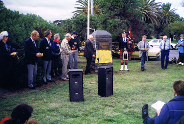
Photograph, 'Glen Huntley' 150th anniversary of arrival - images collection
Victorias first quarantine station was established in Port Ormond on 24 April 1840 when the government immigrant ship "Glen Huntley" arrived in the Port Phillip District flying the yellow quarantine flag . The site is marked by a cairn and plaque that was unveiled in 1985. In 1990 a second plaque was affixed to the cairn to mark the 150th anniversary of the arrival of the ship. It was unveiled at a gathering of descendants of the original passengers on 22 April 1990 by the oldest known descendant, Albert John Buntine MM.Colour photographInscription on 150th anniversary plaque: This plaque commemorates the 150th anniversary of the arrival of the ship 'Glen Huntley' at a gathering of descendants of the original passengers. Unveiled on April 22nd 1990 by Albert John Buntine MM, aged 95. Oldest known descendent. Anderson, Davidosn, Dingwall, McCleery, McDougal, McIntosh, Pattison, Somerville, Brisbane, Kirkwood, McGaskell, McDonald, McGregor, McKenzie, Turnbull, Walker, Armstrong, Henderson, Mathewson, McPherson, Robertson, McKinnon, Whitlock, Stewart, Cameron, Cummins, Hewison, Maskill, Mathers, McKinan, McKinny, McLaren, Burnie, Clarke, Denham, Fraser, Harper, Mercer, McColl, McLeod, Clarke, Duff, Roy, Seat, Stow, Tait, Ward, Craig, Grant, McKay, Mefan, Munro, Nicol, Smith, Young. The plaque marking the 150th anniversary of the ship's arrival was placed below the plaque that was attached to the cairn in 1985. The inscription on the original plaque is: This cairn marks the site of Victorias first quarantine station, which was established on the 24th April 1840 when the government emigrant ship "Glen Huntley" arrived in the Port Phillip District flying the yellow quarantine flag. The site became St Kilda's first official burial ground and the graves of the early colonists remained here until 1898 when the remains were re-interred in the St Kilda Cemetery. Unveiled by the Hon. R W Walsh MLA Member for Albert Park, Minister for Public Works, Assistant Minister for Employment and Industrial Affairs, 7th November 1985. This project was initiated by the Historical Society of St Kilda and sponsored by the Lions Club of Elwood for the 150th Anniversary of the State of Victoria. Logo Victoria 150.glen huntly, glenhuntly, albert john buntine, elwood, point ormond, glen huntley -
 Flagstaff Hill Maritime Museum and Village
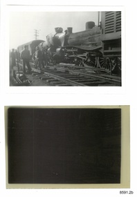
Photograph - Photograph and Negative, 1952
'Moriac, 1952 On 13 April 1952, a woman was killed and seven people were seriously injured when two passenger trains collided. A Melbourne-bound train collided with a Warrnambool-bound train, which was still shunting into siding at the station to allow the Melbourne-bound train to pass it on the single track. Both engines were derailed. The victim was in the first carriage of the Melbourne-bound train, which was telescoped after being forced into the tender of the locomotive. https://en.wikipedia.org/wiki/Railway_accidents_in_Victoria' 'April 12th 1952 7.52 p.m. Two passenger trains collided head on, on Warrnambool line near Moriac just out of Geelong. One killed four injured.' https://trove.nla.gov.au/newspaper/article/244373869?searchTerm=1952%20rail%20accident%20warrnambool ONE DEAD, MANY INJURED IN VIC. RAIL CRASH MELBOURNE, Saturday. — A woman was killed and seven persons were seriously injured when two passenger trains collided head-on at Moriac (59 miles south of Melbourne), near Geelong, at 8.15 tonight. Both engines were derailed, and the first carriage of the Geelong-bound train was telescoped by the coal tender. The dead woman was in this carriage. The trains involved were the 3.25 p.m. passenger train from Port Fairy to Geelong, and the 5.50 p.m. train from Melbourne to Warrnambool, which passed through Geelong at 7.05 p.m. ONE SHUNTING The Warrnambool-bound train had stopped at Moriac and was shunting into a siding to allow the other train to pass along the single track when the crash occurred. The impact hurled the Warrnambool-bound train backwards and the two engines, badly wrecked, came to rest 30ft apart. One engine hung at an acute angle on its side and the crew« were badly scalded by escaping steam. The crash was heard several miles away and hundreds of people rushed to the scene. Two ambulances were called from Geelong, and ambulance men joined railwaymen and volunteers in freeing the injured from badly damaged carriages. MANY SHOCKED Many other passengers were slightly hurt or badly affected by shock. They were treated on the spot. Mr. T. Mather, newsagent and postmaster at Moriac, said the noise of the crash startled him and he was on the scene in a matter of minutes. "There was great confusion," he said. "People on the trains were calling out for help. Many feared a fire would break out. However, we soon got relief gangs together and set to work to free those trapped in the wrecked carriage. One woman was dead, and a man seemed to be dead or dying." Special buses were chartered by the Railway Department to convey the passengers to their destinations. The line was blocked, but repair gangs were soon at work clearing the debris. https://trove.nla.gov.au/newspaper/article/18490332# This photograph and negative belonged to Dr. William Roy Angus. It was donated to Flagstaff Hill Maritime Village by his daughter, Bernice McDade. It is part of the “W.R. Angus Collection” includes historical medical equipment, surgical instruments and material once belonging to Dr Edward Ryan and Dr Thomas Francis Ryan, (both of Nhill, Victoria) as well as Dr Angus’ own belongings. The Collection’s history spans the medical practices of the two Doctors Ryan, from 1885-1926 plus that of Dr Angus, up until 1969. ABOUT THE “W.R.ANGUS COLLECTION” Doctor William Roy Angus M.B., B.S., Adel., 1923, F.R.C.S. Edin.,1928 (also known as Dr Roy Angus) was born in Murrumbeena, Victoria in 1901 and lived until 1970. He qualified as a doctor in 1923 at University of Adelaide, was Resident Medical Officer at the Royal Adelaide Hospital in 1924 and for a period was house surgeon to Sir (then Mr.) Henry Simpson Newland. Dr Angus was briefly an Assistant to Dr Riddell of Kapunda, then commenced private practice at Curramulka, Yorke Peninsula, SA, where he was physician, surgeon and chemist. In 1926, he was appointed as new Medical Assistant to Dr Thomas Francis Ryan (T.F. Ryan, or Tom), in Nhill, Victoria, where his experiences included radiology and pharmacy. In 1927 he was Acting House Surgeon in Dr Tom Ryan’s absence. Dr Angus had become engaged to Gladys Forsyth and they decided he further his studies overseas in the UK in 1927. He studied at London University College Hospital and at Edinburgh Royal Infirmary and in 1928, was awarded FRCS (Fellow from the Royal College of Surgeons), Edinburgh. He worked his passage back to Australia as a Ship’s Surgeon on the on the Australian Commonwealth Line’s T.S.S. Largs Bay. Dr Angus married Gladys in 1929, in Ballarat. (They went on to have one son (Graham 1932, born in SA) and two daughters (Helen (died 12/07/1996) and Berenice (Berry), both born at Mira, Nhill ) According to Berry, her mother Gladys made a lot of their clothes. She was very talented and did some lovely embroidery including lingerie for her trousseau and beautifully handmade baby clothes. Dr Angus was a ‘flying doctor’ for the A.I.M. (Australian Inland Ministry) Aerial Medical Service in 1928 . Its first station was in the remote town of Oodnadatta, where Dr Angus was stationed. He was locum tenens there on North-South Railway at 21 Mile Camp. He took up this ‘flying doctor’ position in response to a call from Dr John Flynn; the organisation was later known as the Flying Doctor Service, then the Royal Flying Doctor Service. A lot of his work during this time involved dental surgery also. Between 1928-1932 he was surgeon at the Curramulka Hospital, Yorke Peninsula, South Australia. In 1933 Dr Angus returned to Nhill and purchased a share of the Nelson Street practice and Mira hospital (a 2 bed ward at the Nelson Street Practice) from Dr Les Middleton one of the Middleton Brothers, the current owners of what previously once Dr Tom Ryan’s practice. Dr Tom and his brother had worked as surgeons included eye surgery. Dr Tom Ryan performed many of his operations in the Mira private hospital on his premises. He had been House Surgeon at the Nhill Hospital 1902-1926. Dr Tom Ryan had one of the only two pieces of radiology equipment in Victoria during his practicing years – The Royal Melbourne Hospital had the other one. Over the years Dr Tom Ryan had gradually set up what was effectively a training school for country general-practitioner-surgeons. Each patient was carefully examined, including using the X-ray machine, and any surgery was discussed and planned with Dr Ryan’s assistants several days in advance. Dr Angus gained experience in using the X-ray machine there during his time as assistant to Dr Ryan. When Dr Angus bought into the Nelson Street premises in Nhill he was also appointed as the Nhill Hospital’s Honorary House Surgeon 1933-1938. His practitioner’s plate from his Nhill surgery is now mounted on the doorway to the Port Medical Office at Flagstaff Hill Maritime Village, Warrnambool. When Dr Angus took up practice in the Dr Edward and Dr Tom Ryan’s old premises he obtained their extensive collection of historical medical equipment and materials spanning 1884-1926. A large part of this collection is now on display at the Port Medical Office at Flagstaff Hill Maritime Village in Warrnambool. In 1939 Dr Angus and his family moved to Warrnambool where he purchased “Birchwood,” the 1852 home and medical practice of Dr John Hunter Henderson, at 214 Koroit Street. (This property was sold in1965 to the State Government and is now the site of the Warrnambool Police Station. and an ALDI sore is on the land that was once their tennis court). The Angus family was able to afford gardeners, cooks and maids; their home was a popular place for visiting dignitaries to stay whilst visiting Warrnambool. Dr Angus had his own silk worm farm at home in a Mulberry tree. His young daughter used his centrifuge for spinning the silk. Dr Angus was appointed on a part-time basis as Port Medical Officer (Health Officer) in Warrnambool and held this position until the 1940’s when the government no longer required the service of a Port Medical Officer in Warrnambool; he was thus Warrnambool’s last serving Port Medical Officer. (Masters of immigrant ships arriving in port reported incidents of diseases, illness and death and the Port Medical Officer made a decision on whether the ship required Quarantine and for how long, in this way preventing contagious illness from spreading from new immigrants to the residents already in the colony.) Dr Angus was a member of the Australian Medical Association, for 35 years and surgeon at the Warrnambool Base Hospital 1939-1942, He served as a Surgeon Captain during WWII1942-45, in Ballarat, Victoria, and in Bonegilla, N.S.W., completing his service just before the end of the war due to suffering from a heart attack. During his convalescence he carved an intricate and ‘most artistic’ chess set from the material that dentures were made from. He then studied ophthalmology at the Royal Melbourne Eye and Ear Hospital and created cosmetically superior artificial eyes by pioneering using the intrascleral cartilage. Angus received accolades from the Ophthalmological Society of Australasia for this work. He returned to Warrnambool to commence practice as an ophthalmologist, pioneering in artificial eye improvements. He was Honorary Consultant Ophthalmologist to Warrnambool Base Hospital for 31 years. He made monthly visits to Portland as a visiting surgeon, to perform eye surgery. He represented the Victorian South-West subdivision of the Australian Medical Association as its secretary between 1949 and 1956 and as chairman from 1956 to 1958. In 1968 Dr Angus was elected member of Spain’s Barraquer Institute of Barcelona after his research work in Intrasclearal cartilage grafting, becoming one of the few Australian ophthalmologists to receive this honour, and in the following year presented his final paper on Living Intrasclearal Cartilage Implants at the Inaugural Meeting of the Australian College of Ophthalmologists in Melbourne In his personal life Dr Angus was a Presbyterian and treated Sunday as a Sabbath, a day of rest. He would visit 3 or 4 country patients on a Sunday, taking his children along ‘for the ride’ and to visit with him. Sunday evenings he would play the pianola and sing Scottish songs to his family. One of Dr Angus’ patients was Margaret MacKenzie, author of a book on local shipwrecks that she’d seen as an eye witness from the late 1880’s in Peterborough, Victoria. In the early 1950’s Dr Angus, painted a picture of a shipwreck for the cover jacket of Margaret’s book, Shipwrecks and More Shipwrecks. She was blind in later life and her daughter wrote the actual book for her. Dr Angus and his wife Gladys were very involved in Warrnambool’s society with a strong interest in civic affairs. He had an interest in people and the community They were both involved in the creation of Flagstaff Hill, including the layout of the gardens. After his death (28th March 1970) his family requested his practitioner’s plate, medical instruments and some personal belongings be displayed in the Port Medical Office surgery at Flagstaff Hill Maritime Village, and be called the “W. R. Angus Collection”. All rail accidents are serious, especially those involving fatalities.Photograph and negative showing two steam locomotives that appear to have collided head on. Also a newspaper article about the collision. From the W.R. Angus Collection.1139 on the back of the photograph together with multiple 'Ilford' brand marks.flagstaff hill maritime museum and village, great ocean road, shipwreck coast, rail accident, moriac, 1952, fatality, dr w r angus -
 Eltham District Historical Society Inc
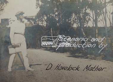
Document - Photograph, Donald Havelock Mather, Papers of Donald Havelock Mather of Kooringarama Films, Oct. 1927
These papers held by the National Library of Australia focus on the film “Borrowed Plumes” shot entirely in Eltham over ten days in October 1927. Some of the location shots are of Main Road near the bridge taken a year after the concrete bridge was opened.borrowed plumes (film), donald havelock mather, eltham, eltham south, kooringoorama films, main road, main road bridge, wingrove park -
 Federation University Historical Collection
Book, Donald Douglas Mather, Diary 1968
Red hard covered Norman Diary 1968. Daiiy happenings, historical notes (especially on gold), Ballarat, Gold Discovery, golden point gold monument.gold, gold discovery, gold monument, golden point -
Victoria Police Museum
Corkscrew
The corkscrew was discovered in a box with a 1906 newspaper article concerning the Victoria Police Museum and its collection. In it Inspector Cawsey speaks of the corkscrew as being the same given to him by convicted serial killer Frederick Deeming in 1892.Metal corkscrew on turned wooden handle. A small knife is attached in one end of the handle. The corkscrew worm has a cylindrical shape frame attached to the central stem. A small pin is inserted above this, and can be made loose to allow the cylinder to move further up the stem to remove the corkfrederick deeming, inspector cawsey, murders, emily mather -
Glen Eira Historical Society
Letter - MURRUMBEENA FOOTBALL CLUB
This file contains 2 items: 1/A letter to Caulf Historical Society, requesting any history of Murrumbeena Football Club, from R. Gould. Reply from T.J. Hart advising that no information on the club is held by the society. 2/A fifty page book on the history of Murrumbeena Football Club, from foundation in 1927 to 1976. Includes 7 team photocopied photographs and one of the pavilion after completion in 1922, book written by R. Gould.gould ross, murrumbeena football club, football, football clubs, ‘dick’s horse paddock’, butchers, murrumbeena, great dandenong road, murrumbeena road, n.r. cooper, market gardens, orchards, carnegie rovers, oakleigh juniors, oakleigh district junior, football association, committees of management, murrumbeena junior football club, dick r., armstrong j., silverman dr. i., phillips r. cr., mudge les, truman v., bristow l., richardson , truman t., robertson, carnegie rovers, bentleigh, oakleigh juniors, ted pelling’s horse stables, stables, kangaroo road, moore george, armstrong fred, tinsley roy, naylor reg, ward bill, hunter mr., cox mr., scivenor mr., marian mr., wilde mr., townley mr., mudge mr., hay mr , ferguson mr., wilde wal, pelling e., watkins e., giles mr., young mr., paterson mr., reid mr., ross mr., walker mr., lyre mr., cannon mr., ronaldson tom, pearson , hall , collaghan jack, dennis, wlash, cannon, rickets, ferguson, wotes, hay, washbrooke, wilde , phillipson, welch, brown, cox, sharp, thomas, palmer, harris e., dick a., caulfield-dandenong, junior football association, metropolitan amateurs, pavilions, caulfield city council, murrumbeena amateurs, miss football queen, ralph miss, welch vic, emmins ‘titch’ g., bone r., havell, ellis r. (bob), pew t., stock a., riley wal, harris ‘codger’ roy, biddington j., nicholson a., bernes a.c., healey g., riley w., summerfield d., lee e., harris j., bass j., denning j., phillips c., king f., weatheral n.w., stewart s., rolfe h., dalgleish s., malone l., simpson e., kain a., rennie w., sloan a., painter e., bernes c., biddington g., parker c., willmott n., murrumbeena cricket club, corbett, murrumbeena districts, holden ‘rusty’, crundy, dean, taylor, bourke, moore, stewart, hause, clarke, gear, page, rowe bill, mathers alf, awards, farrell r., oakley r., escott l., callaghan t., mathers r., andrew j., halfpenny j., howland w., m