Showing 676 items matching "mine shaft"
-
 Bendigo Historical Society Inc.
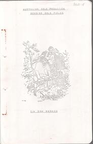
Document - MINING IN BENDIGO COLLECTION: BENDIGO GOLD FIELDS, 1968
... for the years 1851 to 1890, lines of reef, mine shafts and depth..., yield for the years 1851 to 1890, lines of reef, mine shafts ...Typed copy of the Bendigo Gold Fields , collected and arranged by V. R. Dwyer, 1968. On front cover: Australian Gold Production Bendigo Gold Field. Image of tin dish washing. Cover has an image of two people tin dish washing. Notes include a brief history of gold in Australia, Bendigo Goldfield yields, Bendigo Gold Nuggets, Victorian Nuggets, gold prices, yield for the years 1851 to 1890, lines of reef, mine shafts and depth, location, public buildings and organisations and mines listed for each reef. Typed copy of this document is held in Folder 130, number 3621.18.cottage, miners, mining in bendigo, bendigo gold fields index, v r dwyer, strzelecki, edward hargreaves, thomas hancock, henry frenchman, wittscheibe, ballerstedt, fortuna villa, george lansell, the rocks, victoria nugget, dascombe nugget, welcome stranger, welcome nugget, canadian nugget, sarah sands, lady hotham, maryborough, heron nugget, blanche barkley, vicount canterbury, precious nugget, poseidon, gold prices, gold yield 1851 - 1890, location of shafts, mechanics institute, old masonic hall, court, st killians, forrest st methodist church, hospital, baptist church, bendigo gas company, st andrews presbyterian church, bendigo benevolent home, railway, st marys church of england, bendigo m p building society, st pausl church of england, high school, city family hotel, fire brigade, b u f s dispensary, synagogue, beehive store, school of mines, bendigo miners association, st marys convent, dr backhaus, st mathews long gully, salvation army, post office, art gallery, sacred heart cathedral, eaglehawk town hall -
 Ringwood and District Historical Society
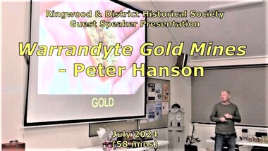
Mixed media - Video, RDHS Guest Speaker Presentation - "Warrandyte Gold Mines" - Peter Hanson
... diggings in the area, with images, maps and drawings of the mines..., maps and drawings of the mines, tunnels, shafts and structures ...Digitised video (2.73GB). Duration: 58 minutes. Recorded July, 2024. (Video is available for viewing at Ringwood & District Historical Society Archives by appointment)Guest Speaker, Peter Hanson grew up in Warrandyte surrounded by signs of gold mining activities including in his own back yard. In this presentation, Peter talks about the numerous diggings in the area, with images, maps and drawings of the mines, tunnels, shafts and structures above and below ground. -
 Bendigo Historical Society Inc.
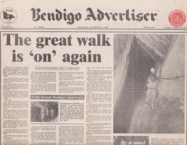
Newspaper - BENDIGO MINING, WALKING UNDERGROUND FROM SPRING GULLY TO EAGLEHAWK
... of the Central Deborah Gold Mine shaft (270 m) through a series... Mine shaft (270 m) through a series of tortuous and at times ...Newspaper article, Bendigo Advertiser, Thursday October 13, 1988, page 1. It was said in the 'heyday of Bendigo's gold mining it was possible to walk underground from Spring Gully to Eaglehawk' Article describes a walk done in 1988 from the 8th level of the Central Deborah Gold Mine shaft (270 m) through a series of tortuous and at times hazardous drives, stopes, shafts and cross overs to the 8th level of the North Deborah Gold Mine. Steven Hinde, Bendigo Mining's Chief Geologist lead the trek, which proved it was still possible to go down one shaft and emerge up another. When Bendigo Mining dewatered the Central Deborah shaft it uncovered the old connecting passages.bendigo, mining, central deborah gold mine -
 Clunes Museum
Photograph, EDMUND STENDO, TOWN OF CLUNES, 1886
... as a goldmining town The view shows the headframes of several mine shafts... the headframes of several mine shafts, the Central Clunes Q.M.Co ...CLUNES TOWNSHIP IN 1886.1 BLACK WOODEN FRAMED PHOTOGRAPH OF CLUNES. HAND TINTED WITH A NARRATIVE WHICH WAS GLUED ONTO THE GLASS. VIEW LOOKING SOUTH NEAR THE PRESENT DAY SCENIC ROAD LOOKOUT. .2 BROWN WOODEN FRAMED PHOTOGRAPH OF THIS SKETCH. WITH MATT BORDER..1 TOWN OF CLUNES - Population 4874 - Number of dwellings 1100. Gold first discovered here 1st July 1851 Printed narrative: A hand-tinted photo-engraving from the Handbook of Victoria, published for the Colonial and Indian Exhibition in London, 1886. Looking south from near the present-day Scenic Road lookout, the illustration projects the image of Clunes as a goldmining town The view shows the headframes of several mine shafts, the Central Clunes Q.M.Co., and the Boundary, No.1 and No.2 shafts of the South Clunes G.M.Co. The headframe on the skyline in the middle distance was probably that of the Bute & Downes Amalgamated G.M.Co., near the railway station. .2 PAPER CERTIFICATE OF AUTHENTICITY ON REAR OF FRAME.colonial and indian exhibition in london 1886, bute & downes amalgamated, buildings, mining -
 The Beechworth Burke Museum
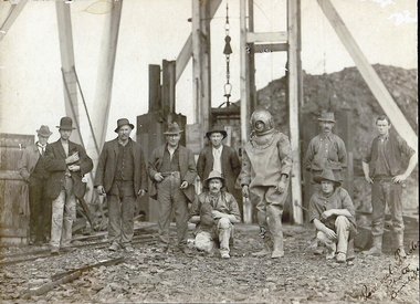
Photograph
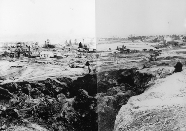
... mine shaft. There is a bridge entering the building, which... mine shaft. There is a bridge entering the building, which ...This photograph depicts four men standing near a large unidentified building. This building is the entrance to a deep lead mine shaft. There is a bridge entering the building, which was used to access the elevator to the shaft. Deep lead mining involved placing large shafts into the ground which miners use to access deeper locations in order to excavate the rocks in the search for lead. Deep lead mining was highly dangerous as roofs could cave in of the soil was loose. Therefore, this particular mining considered to be highly undesirable profession as many miners did not want to work long hours nor risk their lives in the search for lead. Indigo Shire was a large area where deep lead mining took place, and thus the landscape and environment was largely impacted by these mining businesses. The Indigo Shire grew in population and wealth in the early 1850s when people came into this location in the hopes of finding gold and making a fortune. Ultimately, the accessibility and availability of gold and precious metals decreased once the gold reserves dried up and alongside this, the large population moved away. The Ovens was also heavily impacted environmentally as deep mining resulted in the change in land formation.The search for gold is ingrained into the history of Victoria and therefore, images like this one which portray an open cut sluicing site can reveal important information for society and technology for the date when the photograph was taken. This image is of important historical significance for its ability to convey information about the methods used to find gold in Indigo Shire. It also shows a location where deep mining was undertook which provides insight into the impact of deep mining on the environment at a time when it was done. This image is important for current research into the history of Indigo Shire, a region in Victoria's north-east. Therefore, this image has the capacity to be beneficial for research into society and the motivations of those living and working in this region during this period and therefore, has social significance. The Beechworth Burke Museum has additional images relating to deep lead mining and Indigo Shire which can be analysed and studied alongside images like this one.Sepia coloured retangular photo printed on gloss photographic paper.Reverse: 1997, 2510/ A02570/ Deep Lead Mining/ page 94/ 65%/ Burke Museum, Photo 44beechworth, burke museum, indigo shire, deep lead mining, mining, gold, gold mining -
 Clunes Museum
Photograph, C 1865
... GOLD MINE, CLUNES. NORTH SHAFT, SHOWING POPPET HEAD AND CHIMNEY... GOLD MINE, CLUNES. NORTH SHAFT, SHOWING POPPET HEAD AND CHIMNEY ...PHOTOGRAPH - ORIGINAL SEPIA - PORT PHILLIP AND COLONIAL GOLD MINE, CLUNES. NORTH SHAFT, SHOWING POPPET HEAD AND CHIMNEY. .1 MOUNTED ON CARDBOARD .2 - .4 PHOTO PRINTS .5 PHOTO PRINTPORT PHILLIP AND COLONIAL GOLD MINING COMPANY, CLUNES. CLUNES QUARTZ MINING COMPANY'S NORTH SHAFT. CHANGING SHIFTS. TIME, THREE PM. C. NETTLETON, PHOTO.local history, photography, photographs, mining -
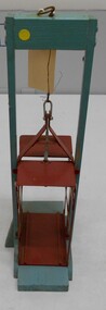 Bendigo Historical Society Inc.
Model - MINERS' SAFETY CAGE MODEL
... on wooden stand to simulate a mine shaft. Cage section is painted... on wooden stand to simulate a mine shaft. Cage section is painted ...Model of miners' cage with safety brake system, mounted on wooden stand to simulate a mine shaft. Cage section is painted red, timber support and base aqua. Cage is suspended from wooden support by thin wire attached to top section of cage to demonstrate its position in a mineshaft and the operation of the safety brake system. Small metal crutch levers on side of cage gripping wooden guides. When tension ceases in rope a pair of crutch levers grab strongly onto the wooden guide strips which run down the sides of a vertical shaft. Safety cages were discussed in "Safety Mining Cages. Report of the Board of Enquiry on Safety Cages 1878-9; together with proceedings of the Board and Appendices". https://www.parliament.vic.gov.au/papers/govpub/VPARL1879-80No31.pdfgold mines -
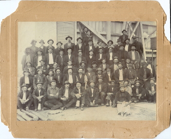 Bendigo Historical Society Inc.
Photograph - VIRGINIA MINE: EAGLEHAWK, 1900 approx
... of miners - c.1900-. James Lerk 5.11.1999 Virginia Mine Shaft J... 5.11.1999 Virginia Mine Shaft J Hooper, Manager Jaw Crusher on L.H.S ...The Virginia Mine Company was registered at Eaglehawk in 1877. The first manager was Henry von der Heyde.black and white photo mounted on brown board. Shift of miners. Virginia Mine Garden Gully (See Back for authority) Mine timbers laying in foreground. R.H. Sixty Men, Timber and Corrugated Iron Clad Structure in background incorporates jawcrusher on left. Board has embossed surround to image. On back in grey lead 'Mrs G. Lonsdale, 38 Victoria Street, Eaglehawk; (faint) Tikitt? (top R.H. Corner) on front in grey lead 'Virginia Mine Eaglehawk. See also copies numbered 200-167-01. James Lerk 26.11.1999 'Virginia Mine, Garden Gully Reef, Eaglehawk - shift of miners - c.1900-. James Lerk 5.11.1999 Virginia Mine Shaft J Hooper, Manager Jaw Crusher on L.H.S of buildingvirginia gold mine, eaglehawk, 1877, von der heyde -
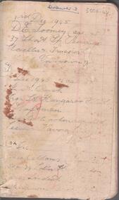 Bendigo Historical Society Inc.
Document - CENTRAL DEBORAH GOLD MINE EMPLOYEES NAMES 1945 TO 1948
... near back of notebook details Spargo Creek Mine expenditure... details Spargo Creek Mine expenditure and shaft team. Document ...Small notebook, lined pages. Names, addresses and mining experience listed in pencil. Dates range from 1945 to 1948. Page near back of notebook details Spargo Creek Mine expenditure and shaft team.bendigo, mining, central deborah gold mine -
 Bendigo Historical Society Inc.
Document - ''THE CHINESE ON THE BENDIGO GOLDFIELD'': PAPER BY ''JOCH'' ( J. O. O'HATTAM)
... and Chinese mines (shafts as well as drives i.e. circular as against... and Chinese mines (shafts as well as drives i.e. circular as against ...''The Chinese on the Bendigo Goldfield'' - draft paper with pencilled and typed annotations by ''Joch'' (J O O'Hattam) - undated. ; last page states ''Extracts from letters in the O'Breen family, and personal research; These letters were written between 1856 and 1899 by Shane O'Breen''. Mention of - two distinct 'groups' of Chinese (Canton & via California) with their stated differences in appearance and type of working; differences between European and Chinese mines (shafts as well as drives i.e. circular as against rectangular; 'smoking' of the shafts and tunnels by the Chinese; space in Chinese camps i.e. crowding; condition of Chinese camps; fire at Emu Creek camp of 1887; names of camps - Golden Square, Jackass Flat, Myers Flat, Kangaroo Flat, White Hills, Kennington, East Bendigo (Grassy Flat) and ''as far out as Diamond Hill''; Constable Ryan disappearance.Shane O'Breenbendigo, chinese, history, goldfields, chinese. o'breen family, shane o'breen, constable ryan. pigtail. cantonese. chinese smoked shafts and tunnels. emu point. opium smoking shop. joss house. golden square. jackass flat, myers flat, kangaroo flat. white hills, kennington. west bendigo (grassy flat). diamond hill. -
 Bendigo Historical Society Inc.
Photograph - Victoria Hill, Bendigo, 1973
... that gold reefs extended below the surface. His 200-foot plus mine... that gold reefs extended below the surface. His 200-foot plus mine ...Gold was discovered on Victoria Hill in 1854 and by 1861, 1,200,000 ounces of gold had been extracted from the site. The first claim was bought for 80 pounds by Prussian immigrant Christopher Ballerstedt and his son Theodore. Christopher Ballerstedt was nicknamed the "Father of the Hill" and was the first to prove that gold reefs extended below the surface. His 200-foot plus mine shafts yielded quartz rich with gold, inspired other miners, and were instrumental in Bendigo becoming the world's deepest and richest goldfield. The site still features relics of nineteenth century mining including quartz crushing machinery and the foundations of George Lansell’s 180 mine. These features are characteristic of Bendigo’s mining history and represent two prominent nineteenth century miners, Christopher Ballerstedt and George Lansell, who held important roles in the development of Bendigo. Victoria Hill Quartz Gold Mines are registered as a site of significance. The site is of historical, archaeological and scientific importance to Victoria. The mines represent the symbolic heart of Bendigo’s gold mining history and the importance that mining played in wealth creation and the development of Victoria. The diggings reserve is accessed from the rear of Albert Richardson Reserve located at 40-56 Marong Road, Ironbark. The site has steep and unformed paths and is closed to the public at dusk. It is important to stay to the paths to avoid the diggings. Interpretive signs help visitors to appreciate the importance of the site and the remaining relics of Bendigo’s mining history.Victoria Hill Ironbark, Bendigo. Photos of the poppet head, sand heap, tailings, shafts and tunnels. Before development into a tourist attraction.history, bendigo, victoria hill, ironbark, diggings -
 Bendigo Historical Society Inc.
Document - Kangaroo Flat Gold Mine Collection: Flora Hill Mine Report, 6th November 1985
... copies of mining records. The main Flora Hill Mine shaft 260 ft... Flora Hill Mine shaft 260 ft (79.2m) in Houlahan Street, near ...Kangaroo Flat Gold Mine Collection. Eight pages (photocopy) of information relating to the Flora Hill Mine, Flora Hill, Bendigo. On first page: 'Bendigo Mining N.L. Mine Information' First two pages contain a summary of the research undertaken by Bendigo Mining N.L. with six additional photocopied pages of annotated copies of mining records. The main Flora Hill Mine shaft 260 ft (79.2m) in Houlahan Street, near Brennan Park Swimming Pool. The Flora Hill reefs were worked from the late 1850's by open cut and shallow shafts, but very little has been recorded about these working or the gold obtained. The Flora Reef Co crushed 200 tons for a return of 25 oz in 1866, a grade suggestive of open cut operations.' The mine was re-opened in 1921, at which time Whitelaw wrote a report. An extract from Whitelaw's report (24th March, 1921) is included in the report. gold mining, bendigo, flora hill mine, south flora reef gold mining company, bendigo mining n.l. -
 Blacksmith's Cottage and Forge
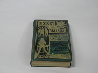
Book, F.W. Niven and Co, History of Ballarat, 1887
... cage descending a mine shaft. On back cover: In black... a mine shaft. On back cover: In black, picture of an aborigine ...This book came into our collection via a donation to the Book Barn, which operates as a second-hand book shop. The donor is unknown.This book was published in 1887, a time of consolidation of wealth after the initial gold rushes in Ballarat in the 1850s. Its full title is 'History of Ballarat from the First Pastoral Settlement to the Present Time.' By William Bramwell Withers, Journalist. Second Edition with Plans, Ilustrations and Original Documents. It is an invaluable history of the origins of Ballarat and its mining history, with a chapter devoted to the Eureka Stockade. Book bound in green cloth on hard cover. On cover: Title incised in black on gold: HISTORY/OF/BALLARAT In gold: REVISED EDITION In black:By/W.B.Withers/PUBLISHED/BY/F.W.NIVEN &Co/Ballarat. Front cover embossed with gold pictures, one of a spray of wattle, one of a spray of eucalyptus leaves, a picture of a miner standing at a winch, and two panoramas of Ballarat, one in its early days as a gold-mining camp, and one as a built-up city. On spine: In green on gold: HISTORY/OF/BALLARAT : BY W.B.WITHERS 1887 Picture of two miners in a lift cage descending a mine shaft. On back cover: In black, picture of an aborigine looking into the sun, which is either rising or setting. On inside front cover: label pasted in. Inscription in gold: PRESENTED TO/THE/MEMBERS/OF THE/Empire Commerce Congress/BY/BALLARAT'S PIONEER DIGGER,/MR.JAMES ODDIE,1851. Front brown flyleaf partially torn off. ballarat gold rush, w.b.withers, eureka stockade, mining history, early maps of ballarat, mr james oddie, empire commerce congress -
 Bendigo Historical Society Inc.
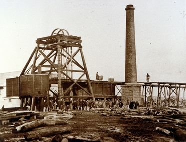
Photograph - TAMBOUR MAJOR MINE AT SPECIMEN HILL, 1920
... males in front of mine shaft. One male in divers suit. Male.... Ten males in front of mine shaft. One male in divers suit ...Black and white photograph mounted on brown board. Ten males in front of mine shaft. One male in divers suit. Male second from L holding small dog. Cage and poppet legs in background. Mullock heap at back. Inscriptions: Hand written on BR corner of photo 'Percival Pinder, Photo, Bendigo' Hand written on board under photo 'Tambour Major GM Coy 846 ft'. On separate card glued to bottom of mount board, printed 'Diver inspecting flooded Tambour Major Mine at Specimen Hill in 1920'. Hand written in ball point pen on back 'Tambour Major' Mine Group photo taken at Tambour Major about 1920. Dad on extreme right, Joe Sheard, Mine Manager in diving suit. A Richardson, 29 Harrison Street' Hand printed in black ink on back 'Diver inspecting flooded Tambour Major Mine in 1920'. On back - circular purple stamp 'Royal Historical Society of Victoria, Bendigo Branch'.Percival Pinder, Bendigomining, surface equipment, tambour major mine, bendigo, mines and mining, miners, mine, specimen hill, flooded mine, diver -
 Bendigo Historical Society Inc.
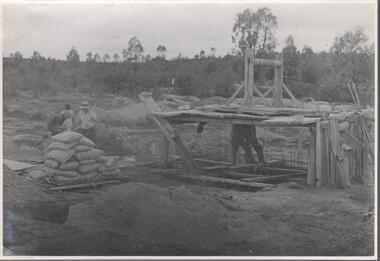
Photograph - Carshalton Gold Mine site, 1935
... mine site with shaft and improvised winch on platform standing... Mine cement concrete collar shaft Written in pencil on back ...Significant to mining history of Bendigo.Black and white photograph : image shows Carshalton gold mine site with shaft and improvised winch on platform standing over shaft. Bags of (presumably) cement on left hand side, two men standing on framing over shaft, three on left hand side of bags of cement. Written in pencil on back of photograph in pencil: 'Pouring concrete collar Carshalton'carshalton gold mine, cement, concrete collar, shaft -
 Stawell Historical Society Inc
Photograph, View from Big Hill Looking North to Newington Road
... Mine and the two shafts of the North Cross mines. On the upper... Mine and the two shafts of the North Cross mines. On the upper ...Mining Scene. In foreground is Scotts Open Cut, on the left is the Great Northern mine, behind that is the Oriental Mine and the two shafts of the North Cross mines. On the upper right is the Magdala Mine. The mines on the horizon could be the Prince Alfred, Prince Patrick, Newington and Pleasant Creek or Little Newington Mine.B/W Scene Man sitting above open cut, looking at buildings and poppet headsstawell, gold mining -
 Bendigo Historical Society Inc.
Slide - DIGGERS & MINING. DIGGERS AND MINERS, c1930s-1940s
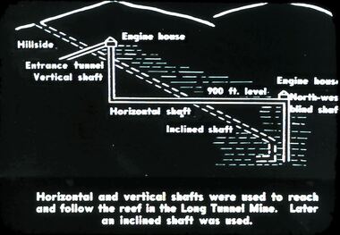
... Tunnel Mine. Later as inclined shaft was used. Markings: 33 994.5... and follow the roof in the Long Tunnel Mine. Later as inclined shaft ...Diggers & Mining. Diggers and miners. Horizontal and vertical shafts were used to reach and follow the roof in the Long Tunnel Mine. Later as inclined shaft was used. Markings: 33 994.5 WAL. Used as a teaching aid.hanimounteducation, tertiary, goldfields -
 Bendigo Historical Society Inc.
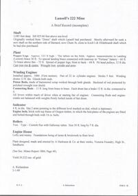
Document - LANSELL'S 222 MINE NOTES ON LANSELL'S 222 MINE
... Mine. Notes on the shaft, plant, winding engine, indicator... Lansell's 222 Mine Mining Equipment 'Denis ' Shaft Koch's ...Hand written page of notes (incomplete) on Lansell's 222 Mine. Notes on the shaft, plant, winding engine, indicator, boilers and engine house. Yield 20,322 ounces of gold. Signed by A Richardson 3/1/68.gold mining, miners' safety cage, lansell's 222 mine, lansell's 222 mine, mining equipment, 'denis ' shaft, koch's & hildebrandt, fortuna battery, a harkness & co, victoria foundry, mines report 1884 page 49, a richardson -
 Bendigo Historical Society Inc.
Photograph - CENTRAL RED WHITE AND BLUE MINE
... The Central Red White and Blue Gold Mine was Bendigo's...The Central Red White and Blue Gold Mine was Bendigo's ...The Central Red White and Blue Gold Mine was Bendigo's leading gold mine from 1910 - 1913. During the mine's operation, the main shaft was sunk 670 metres, and retrieved over 2500KG of gold. The Central Red White and Blue Gold Mine was located on the corner of Chum St and Honeysuckle St in Golden Square.black and white photo - poppet legs, corrugated iron buildings, round brick chimney stack, 3 cylindrical metal tanks, picket fence across from left to RH side of building, Electricity pole at centre..bendigo, gold mining, gold, central red white and blue gold mine, chum street, honeysuckle -
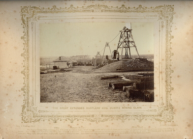 Bendigo Historical Society Inc.
Photograph - VIEWS OF BENDIGO: THE GREAT EXTENDED HUSTLERS CO'S QUARTZ MINING CLAIM, 1875 copy,1970
... , Battery House, Mine Shaft. Three large 'A' frames running a line..., there is an Office, Battery House, Mine Shaft. Three large 'A' frames running ...Sepia photo on cream board. Shows the Great Extended Hustlers Co's. Quartz Mining Claim. In photo, there is an Office, Battery House, Mine Shaft. Three large 'A' frames running a line down to the battery house from the poppet head. Inscription: Above image: 'Views of Bendigo|No.43.'. Below, 'The Great Extended Hustlers Co's. Quartz Mining Claim.', 'N.J.Caire Photo, Sandhurst'. Bottom, 'Casey & Wenborn's Print Forbes & Holmes, Agents',' Office Battery House Main Shaft',' The famous Quartz Claim covers on area of 24 acres, and has six shafts which represent 4000 feet of sinking; there are no less than 13 level and 16 crosscuts, giving a total of 12,000 feet in length. The total amount expended in labour by this Company £228,000. The Quartz raised amounts to 144,500 tons, and it has yielded 188,000 oz's of gold. The amount paid in dividends is £585,600 being nearly £20 per share, employment is given to nearly 200 men. It is stated that this rich mine changed hands in early days for the small sum of £30.'. On Back, RHSV stamp, Bendigo Branch '1959|186'. Nicholas CaireN.J.Caireplace, mining site, great expended hustler quartz mine, see: 'views of bendigo' by n.j.caire -
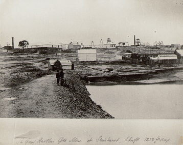 Bendigo Historical Society Inc.
Photograph - THE GREAT HUSTLER GOLD MINE AT SANDHURST, c.1875
... . Inscriptions: 'The Great Hustler, Gold Mine at Sandhurst. Shaft 1250 ft'....: 'The Great Hustler, Gold Mine at Sandhurst. Shaft 1250 ft ...Black and white photograph copy of original. Mining site of The Great Hustler, Gold Mine at Sandhurst. Dam on RH side front, mine buildings (various) trestle way in background. Three people beside dam in foreground. Brick chimney back LH side. Inscriptions: 'The Great Hustler, Gold Mine at Sandhurst. Shaft 1250 ft'.place, mining site, great extended hustler quartz mine -
 Bendigo Historical Society Inc.
Document - MCCOLL, RANKIN AND STANISTREET COLLECTION: GOLDEN CARSHALTON NO LIABILITY, 1949
... No 11257 showing the Carshalton Mines Ltd New Main Shaft, Hansel... Lease No 11257 showing the Carshalton Mines Ltd New Main Shaft ...Documents: Gold Mining Lease No. 11257 FOL.36397 Bendigo 16/8/1949. Golden Carshalton N\L Map of Bendigo Sandhurst Lease No 11257 showing the Carshalton Mines Ltd New Main Shaft, Hansel Mundy Shaft.MCCOLL RANKIN AND STANSISTREETorganization, business, gold mining - legal, mccoll rankin and stansistreet. golden carshalton n\l. mundy shaft. -
 Bendigo Historical Society Inc.
Document - NEW CHUM LINE OF REEF - REFERENCE TO CALEB THOMAS PLANS
... . Has the mine's name, size of shaft and on other pages... the mine's name, size of shaft and on other pages, the height ...Five pages of reference numbers used on Caleb Thomas plans. Has the mine's name, size of shaft and on other pages, the height of the sill. One mine on the Sheepshead Line, the New St Mungo is mentioned. Many mines along the reef are mentioned.document, gold, mines, new chum line of reef, reference to caleb thomas plans, catherine reef extd., new franklin, murchison, catherine reef united, catherine reef (south), acadia catherine, william's united, york & durham, belmont & saxby, ellenborough, sadowa, (old) st mungo, lady barkly, princess alice (sth st mungo), unicorn trib, pheonix, hopewell, united devonshire (princess alex), west united devonshire, east united devonshire, duchess of edinburgh, south devonshire, duchess tribute, new st mungo, new st mungo, new vict catherine, gt extd vict, herc new chum (late pearl), pearl south, north herc & energetic, herc & energetic, ironbark, vict consols, south new chum, lansell's 616, south belle vue, eureka extd, new chum rly, south old chum, new chum consolidated, ellesmere (south shaft), garibaldi, cravens, young chum, ellesmere nth shaft, new chum united, new chum vic, old chum, lazarus, cent new chum, lansell's 222, north old chum, lansell's big 180, advents advance, gt cent vict, hamboldt, ballerstedt, victoria quartz, herc & energetic, herc (old), shenandoah, victoria reef gold, victoria consols -
 Bendigo Historical Society Inc.
Document - OLD CHUM MINE - NOTES ON THE OLD CHUM MINE
... the popularity and locality of the mine. The shaft being well timbered... the popularity and locality of the mine. The shaft being well timbered ...Handwritten notes on the Old Chum Co. Ref. M. D. Early History of Old Chum & The Old Chum Coy. Notes mention the popularity and locality of the mine. The shaft being well timbered. List of dates, tons of ore and the ounces of gold obtained from it, Dividends paid, Mine worked by steam. Engine 18 H. P. 13 in dia cylinders. No pumps, mine perfectly dry. No crushing battery. Mine crushed at Endeavour and the 'Fortuna'. Keeping 3 batteries going altogether. Mine registered 16/6/1871. Notes prepared by Albert Richardson.document, gold, old chum mine, old chum mine, notes on the old chum mine, endeavour, fortuna, m d early history of old chum & the old chum coy -
 Bendigo Historical Society Inc.
Document - ALBERT RICHARDSON COLLECTION: DEEPEST SHAFT AND WINZES VICTORIA 1851 - 1911
... shafts and winzes Victoria 1851 - 1911. Reference: See Mines...BENDIGO Mining shaft depths Albert Richardson Handwritten ...Handwritten, 2 page, table of information showing mine name, alluvial or quartz and shaft depth. On top of page ' Deepest shafts and winzes Victoria 1851 - 1911. Reference: See Mines Report 1911, E.J. Dunn 10.11.08' Victoria Quartz mine Bendigo was the deepest. For example, entry reads: Victoria Quartz Mine, Bendigo, shaft 4270 plus 220 feet = total 4490 feet. Winze 385 feet from 4228 feet , No 37 Plat. Total 4613 feet from surface. Penthouse and cistern at 4228 feet. Shaft sunk to 4558 feet. Signed A.R.Albert Richardsonbendigo, mining, shaft depths -
 Bendigo Historical Society Inc.
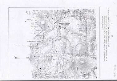
Document - DIAMOND HILL AREA MAP
... and further south, with shafts and mine names marked....' on north side and further south, with shafts and mine names marked ...Map copy, 2 pages, from 'Old Mines Department Plan, Dept of Conservation and Environment File No W91006, 16.6.1972' Map shows Golden Gully area with 'Town and Country Hotel' on north side and further south, with shafts and mine names marked.bendigo, mining, diamond hill -
 Ballarat Heritage Services
Photograph - Photograph - Colour, Corner of Vickers Street and Albert Street, Sebastopol, 2020, 07/04/2020
... The South Star Mine commenced operations in the 1880s... Office goldfields The South Star Mine commenced operations ...The South Star Mine commenced operations in the 1880s and worke the quartz laods after the great floods of 1875 forced the closure of most alluvial mines. The South Star Mine sunk its first shaft in 1886, but broke into old alluvial workings and had to be abandoned because of flooding. The second shaft commenced in 1887, and was the deepest eer sunk in the Ballarat district, reaching 956 metres. 180 men worked three shifts each day.Colour photograph of the site of the South Star Mine in Sebastopol. sebastopol, albert street, south star mine, mining -
 Bendigo Historical Society Inc.
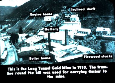
Slide - DIGGERS & MINING. DIGGERS AND MINERS, c1930s
... for carrying timber to the mine. Engine House, Inclined Shaft, Battery... and miners. This is the Long Tunnel Gold Mine in 1910. The tram-line ...Diggers & Mining. Diggers and miners. This is the Long Tunnel Gold Mine in 1910. The tram-line roamed the hill was used for carrying timber to the mine. Engine House, Inclined Shaft, Battery, Boiler House and Firewood stacks are marked on the slide. Markings: 30 994.5 WAL. Used as a teaching aid.hanimounteducation, tertiary, goldfields -
 Bendigo Historical Society Inc.
Document - NEW CHUM & VICTORIA LINES OF REEF - NOTES ON JOHNSON'S REEF
... Alexander Shaft, Johnson's no 1 Mine, North Johnson's with notes... Devonshire Shaft Johnson's Reef Garden Gully Line Johnson's No 1 Mine ...Handwritten notes mention 'History of Bendigo by G Mackay, St Mungo Line of Reef from the Belmont Mine, Princess Alexander Shaft, Johnson's no 1 Mine, North Johnson's with notes on buildings, etc. and date 22/9/1892, and the Johnson's Reef Extended dated 29/10/1892, with note on building, mullock heap, and sill 779.18 above sea level. Also mentioned are Leo Chapman and Tom Sayers.document, gold, new chum & victoria lines of reef, notes on johnson's reef, history of bendigo, g mackay, mines' dept, st mungo line of reef, e j dunn report 21/10/92, princess alexander shaft, united devonshire shaft, johnson's reef, garden gully line, johnson's no 1 mine, north johnson's, e j dunn's report 29/10/1892, johnson's reef extended, leo chapman, tom sayers -
 The Beechworth Burke Museum
Photograph - Photograph - Reproduction, Unknown
... mine shaft, a vertical access passageway allowing miners... mine shaft, a vertical access passageway allowing miners ...This image is a reproduction of an 1899 original depicting the 'Williams Good Luck Mine' on the Mopoke Reef (also called 'Morepork Gully') in the Dingle Ranges, approximately three miles from Beechworth. The foreground of the image is littered with piles of smashed rock and detritus, known as ‘mullock’, beside a reinforced mine shaft, a vertical access passageway allowing miners to enter the mine and haul ore out using lifting technology such as a poppet heads, whims or windlasses. A group of miners and a dog appear close to an open-sided miner’s hut. Following the discovery of gold at Beechworth in 1852, rushes quickly followed at surrounding creeks and gullies in the district. In the late nineteenth and early twentieth centuries, small syndicates of miners continued to work old or abandoned quartz reefs, often persisting without the assistance of heavy machinery to remove the large amounts of rock, in order to obtain yields at ever greater depths. The group of miners in this photograph are Mr. Roger Williams and Sons, who revived operations at the ‘Old Good Luck’ mine on the Mopoke Reef in the Dingle Range near Beechworth around 1892, working the site for more than two decades. An emigrant from Cornwall with experience in the tin mining industry, 19 year old Roger Williams senior sailed to New Zealand in 1840, then to Australia where he spent time in the Bendigo Gold Fields before settling in Beechworth in the early 1860s. Mr Williams senior worked on various mining activities in the district, including the Rocky Mountain Tunnel project. Conversant with the character of gold-bearing reefs in the area, the syndicate dug an eight hundred foot tunnel, digging down as far down as two hundred feet with little capital save their labour, to connect and provide better working access to the mass of reefs and veins in the vicinity. Progress was hampered by poor air quality charged with fumes from dynamite and large quantities of rock had to be crushed to obtain payable yields. The Victorian Goldfields are filled with ruins and remnants of the area's rich mining history, ranging from small alluvial diggings to the remains of huge mining companies. Site names often changed several times throughout the nineteenth and twentieth centuries. Some sites were abandoned and forgotten, others were worked continuously over many decades. The names of mines were often repeated at different locations throughout the Victorian Goldfields. For example, there is a Mopoke Gully heritage mine near Fryers Creek, Victoria. 'Mopoke' is a common onomatopoeic name for Morepork and Australian Boobook owls. This image has historical, social and research significance for patterns of emigration during of the Victorian Gold Rush, and the historical, social and environmental impacts of mining at Beechworth at the turn of the nineteenth and twentieth centuries. As gold became scarce and government support and large company investment waned, poor hard-working miners laboured intensively to make a living through periods of high unemployment. This image can be compared and studied alongside other historical mining photographs and objects in the Burke Museum Collection. It has potential to improve our understanding of miners working conditions and the shifting character of mining in the Beechworth district. Black and white rectangular reproduction photograph printed on matte photographic paper.Obverse: Williams Good Luck Mine Beechworth / Roger! / Reverse: 6858 / burke museum, beechworth museum, beechworth, gold fields, gold rush, victorian gold rush, gold ming history, colonial australia, australian gold rushes, mining technology, beechworth historic district, indigo gold trail, migration, indigo shire, good luck gold mine, victorian goldfields, mining syndicates, gold fever, quartz-mining, small-scale mining, old good luck mine, mopoke gully, quartz reefs beechworth