Showing 553 items
matching mine sites
-
 Bendigo Historical Society Inc.
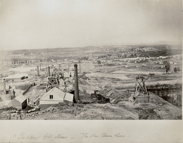
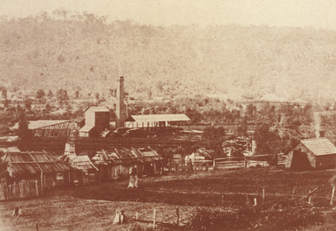
Photograph - THE NEW CHUM LINE OF REEF, c.1870
... mining site. Mines in foreground. Homes in background. Looking... view of the New Chum Line mining site. Mines in foreground ...Black and white photograph. Large view of the New Chum Line mining site. Mines in foreground. Homes in background. Looking South towards Golden Square. Inscriptions: on front - handwritten - 'Sandhurst Gold Mines - The New Chum Line'. C1873, earlier than NH Caire (1875) - James Lerk 12.11.1999.place, mining site, new chum -
 Bendigo Historical Society Inc.
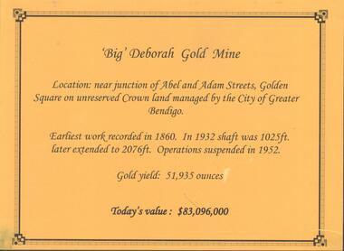
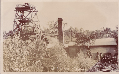
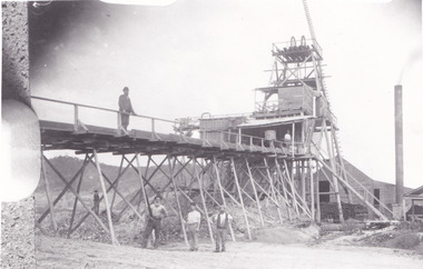
Photograph - DEBORAH GOLD MINE, GOLDEN SQUARE
... by Horwood's Foundry, Bendigo. Photos of mine site taken in 2012... was manufactured by Horwood's Foundry, Bendigo. Photos of mine site ...Information display card regarding the 'Big' Deborah Gold Mine, located near the junction of Abel and Adam Street, Golden Square. Earliest work recorded 1860. Shaft 2076 feet. Operations suspended in 1952. Gold yield 51,935 ounces. Battery shed still on site containing a 5 head stamper which was originally a 20 head stamper. The battery was manufactured by Horwood's Foundry, Bendigo. Photos of mine site taken in 2012: a.Engine room concrete footings, iron work visible. Pepper corn trees in background. Pampas grass in foreground. Steel mesh fence on RH side, enclosing the poppet head site. b. Concrete footings, peppercorn tree in background. c. Corrugated iron shed constructed over the stampers. Steel mesh front. d. Steel poppet head, no winding wheel at top. Pampas grass in foreground. e.. Stamper shed and steel poppet legs in background enclosing dilapidated wooden poppet head legs. f. Close up image of weights in stamper room g.Winding wheel on stampers h.Looking upwards to top of stampersbendigo, mining, deborah gold mine -
 Bendigo Historical Society Inc.
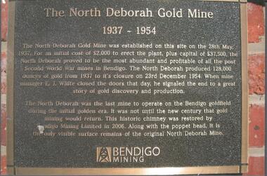
Photograph - NORTH DEBORAH GOLD MINE BENDIGO MINING PLAQUE
... of the original North Deborah Mine.' The mine site is situated off Breen... North Deborah Mine.' The mine site is situated off Breen Street ...Metal plaque, gold writing, erected at the site of the former North Deborah Gold Mine when the brick chimney was restored by Bendigo Mining NL. The plaque reads: 'The North Deborah Gold Mine, 1937-1954. The North Deborah Gold mine was established on this site on the 28th May 1937. For an initial cost of 2,000 pounds to erect the plant, plus capital of 37,500 pounds, the North Debnorah proved to be the most abundant and profitable of all the post Second War mines in Bendigo. The North Deborah produced 128,000 ounces of gold from 1937 to its closure on 23rd December 1954. When mine manager E.J. White closed the doors that day he signaled the end to a great story of gold discovery and production. The North Deborah was the last mine to operate on the Bendigo goldfield during the initial golden era. It was not until the new century that gold mining would return. This historic chimney was restored by Bendigo Mining Limited in 2006. Along with the poppet head. It is the only visible surface remains of the original North Deborah Mine.' The mine site is situated off Breen Street in Golden Square.Kay MacGregor 2012bendigo, mining, north deborah mining company -
 Ballarat Heritage Services
Photograph - Colour, Dorothy Wickham, St Just, Cronwall, World Heritage Site
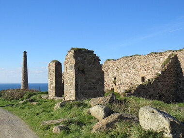
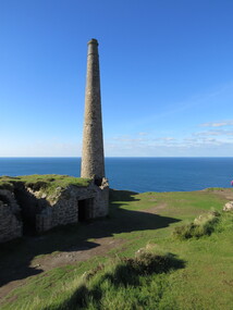
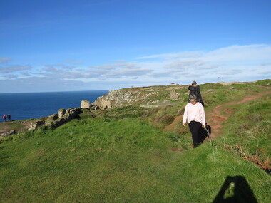
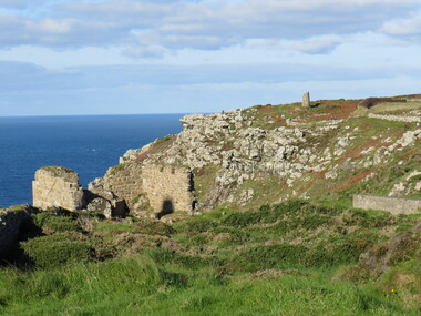
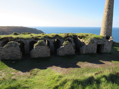
... the largest metalliferous mine site open to the public in the UK... demolition and is now the largest metalliferous mine site open ...A stone’s throw from Land’s End, this is the most westerly Area of the Site. St Just is characterised by big skies, jagged rocks, stark moorland, and iconic clifftop engine houses perched above the Atlantic in some incredible locations. No wonder this dramatic setting has inspired generations of artists, writers and photographers. World-famous for their mineralogy, the mining sites here are extremely well preserved – as is the sense of community amongst the people whose lives they once dominated. This Area’s unique geography and mineralogy meant that undersea mining was more concentrated here than anywhere else in the world in the 18th and 19th centuries. The oldest surviving Cornish beam engine (constructed in 1840) remains in its original engine house at Levant, restored and still working under steam. Geevor, one of the last mines to close in Cornwall (1990), was saved from demolition and is now the largest metalliferous mine site open to the public in the UK. The historic mining town of St Just is home to characteristic rows of granite mine workers’ cottages, public squares, shops, cafés, art galleries and, just off Bank Square, a medieval grassed amphitheatre – the Plen an Gwary or ‘playing place’.st just, world heritage, ellis, penrose, cornwall, mining, mines -
 Ballarat Heritage Services
Photograph - Colour, Dorothy Wickham, St Just, Cornwall, World Heritage Site
... the largest metalliferous mine site open to the public in the UK... demolition and is now the largest metalliferous mine site open ...A stone’s throw from Land’s End, this is the most westerly Area of the Site. St Just is characterised by big skies, jagged rocks, stark moorland, and iconic clifftop engine houses perched above the Atlantic in some incredible locations. No wonder this dramatic setting has inspired generations of artists, writers and photographers. World-famous for their mineralogy, the mining sites here are extremely well preserved – as is the sense of community amongst the people whose lives they once dominated. This Area’s unique geography and mineralogy meant that undersea mining was more concentrated here than anywhere else in the world in the 18th and 19th centuries. The oldest surviving Cornish beam engine (constructed in 1840) remains in its original engine house at Levant, restored and still working under steam. Geevor, one of the last mines to close in Cornwall (1990), was saved from demolition and is now the largest metalliferous mine site open to the public in the UK. The historic mining town of St Just is home to characteristic rows of granite mine workers’ cottages, public squares, shops, cafés, art galleries and, just off Bank Square, a medieval grassed amphitheatre – the Plen an Gwary or ‘playing place’.st just, world heritage,, ellis,, penrose, cornwall, mining, mines -
 Ballarat Heritage Services
Photograph - Colour, Dorothy Wickham, St Just, Cornwall, World Heritage Site
... the largest metalliferous mine site open to the public in the UK... demolition and is now the largest metalliferous mine site open ...A stone’s throw from Land’s End, this is the most westerly Area of the Site. St Just is characterised by big skies, jagged rocks, stark moorland, and iconic clifftop engine houses perched above the Atlantic in some incredible locations. No wonder this dramatic setting has inspired generations of artists, writers and photographers. World-famous for their mineralogy, the mining sites here are extremely well preserved – as is the sense of community amongst the people whose lives they once dominated. This Area’s unique geography and mineralogy meant that undersea mining was more concentrated here than anywhere else in the world in the 18th and 19th centuries. The oldest surviving Cornish beam engine (constructed in 1840) remains in its original engine house at Levant, restored and still working under steam. Geevor, one of the last mines to close in Cornwall (1990), was saved from demolition and is now the largest metalliferous mine site open to the public in the UK. The historic mining town of St Just is home to characteristic rows of granite mine workers’ cottages, public squares, shops, cafés, art galleries and, just off Bank Square, a medieval grassed amphitheatre – the Plen an Gwary or ‘playing place’.st just, world heritage, ellis, penrose, cornwall, mining, mines -
 Ballarat Heritage Services
Photograph - Colour, Dorothy Wickham, St Just, Cronwall, World Heritage Site
... the largest metalliferous mine site open to the public in the UK... demolition and is now the largest metalliferous mine site open ...A stone’s throw from Land’s End, this is the most westerly Area of the Site. St Just is characterised by big skies, jagged rocks, stark moorland, and iconic clifftop engine houses perched above the Atlantic in some incredible locations. No wonder this dramatic setting has inspired generations of artists, writers and photographers. World-famous for their mineralogy, the mining sites here are extremely well preserved – as is the sense of community amongst the people whose lives they once dominated. This Area’s unique geography and mineralogy meant that undersea mining was more concentrated here than anywhere else in the world in the 18th and 19th centuries. The oldest surviving Cornish beam engine (constructed in 1840) remains in its original engine house at Levant, restored and still working under steam. Geevor, one of the last mines to close in Cornwall (1990), was saved from demolition and is now the largest metalliferous mine site open to the public in the UK. The historic mining town of St Just is home to characteristic rows of granite mine workers’ cottages, public squares, shops, cafés, art galleries and, just off Bank Square, a medieval grassed amphitheatre – the Plen an Gwary or ‘playing place’.st just, world heritage, ellis, penrose, cornwall, mining, mines -
 Ballarat Heritage Services
Photograph - Colour, Dorothy Wickham, St Just, Cornwall, World Heritage Site
... the largest metalliferous mine site open to the public in the UK... demolition and is now the largest metalliferous mine site open ...A stone’s throw from Land’s End, this is the most westerly Area of the Site. St Just is characterised by big skies, jagged rocks, stark moorland, and iconic clifftop engine houses perched above the Atlantic in some incredible locations. No wonder this dramatic setting has inspired generations of artists, writers and photographers. World-famous for their mineralogy, the mining sites here are extremely well preserved – as is the sense of community amongst the people whose lives they once dominated. This Area’s unique geography and mineralogy meant that undersea mining was more concentrated here than anywhere else in the world in the 18th and 19th centuries. The oldest surviving Cornish beam engine (constructed in 1840) remains in its original engine house at Levant, restored and still working under steam. Geevor, one of the last mines to close in Cornwall (1990), was saved from demolition and is now the largest metalliferous mine site open to the public in the UK. The historic mining town of St Just is home to characteristic rows of granite mine workers’ cottages, public squares, shops, cafés, art galleries and, just off Bank Square, a medieval grassed amphitheatre – the Plen an Gwary or ‘playing place’.st just, world heritage, ellis, penrose, cornwall, mining, mines -
 Ballarat Heritage Services
Photograph - Colour, Dorothy Wickham, St Just, Cornwall, World Heritage Site
... the largest metalliferous mine site open to the public in the UK... demolition and is now the largest metalliferous mine site open ...A stone’s throw from Land’s End, this is the most westerly Area of the Site. St Just is characterised by big skies, jagged rocks, stark moorland, and iconic clifftop engine houses perched above the Atlantic in some incredible locations. No wonder this dramatic setting has inspired generations of artists, writers and photographers. World-famous for their mineralogy, the mining sites here are extremely well preserved – as is the sense of community amongst the people whose lives they once dominated. This Area’s unique geography and mineralogy meant that undersea mining was more concentrated here than anywhere else in the world in the 18th and 19th centuries. The oldest surviving Cornish beam engine (constructed in 1840) remains in its original engine house at Levant, restored and still working under steam. Geevor, one of the last mines to close in Cornwall (1990), was saved from demolition and is now the largest metalliferous mine site open to the public in the UK. The historic mining town of St Just is home to characteristic rows of granite mine workers’ cottages, public squares, shops, cafés, art galleries and, just off Bank Square, a medieval grassed amphitheatre – the Plen an Gwary or ‘playing place’.st just, world heritage, ellis, penrose, cornwall, mining, mines -
 Federation University Historical Collection
Book, Mount Helen Campus Development Plan, 1970, 1970
... The Ballarat School of Mines is the oldest site... The Ballarat School of Mines is the oldest site of technical education ...The Ballarat School of Mines is the oldest site of technical education in Australia, and is a predecessor institution of Federation University Australia. The Mount Helen campus was originally the tertiary division of the Ballarat School of Mines until 1976. Green covered printed book.mount helen, ballarat institute of advanced education, mount helen campus, harrison, h.j. harrison, vernon, l.h. vernon, j.b. vernon, architecture, campus plan, ballarat school of mines and industries -
 Fire Services Museum of Victoria
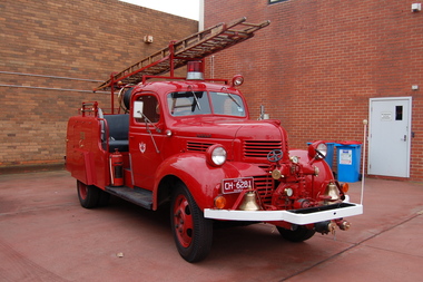
Vehicle - Fire Engine - Pumper "SEC Dodge", "SEC Dodge"
... extension of open cut mine over township site.... extension of open cut mine over township site. Unique only fire ...Maufactured for State Electricity Commission of Victoria (SEC) fire brigade at Yallourn township serving the nearby open cut brown coal mine, briquette manufacturing plant and electricity generating station. Donated to FSMV 19??, on closure of Yallourn Fire Brigade preparatory to closure of township to allow extension of open cut mine over township site.Unique only fire engine of design ever made.Pumper fire engine State Electricity Commission of Victoria (SEC) Fire Brigade, Yallourn, Vic Front mounted pump, ?, ? lpm [ ? gpm] Seat for 4 crew open cross mounted behind cab Ladder, ? m [ ? feet] Water tank ? l [ ? gall] Hose reel ? m [ ? feet] Current vehicle registration - CH6281 SEC logo on both doors Y F B on compartment door on both sides of bodyfire engine, fire engine pumper, dodge fire engine, dodge, yallourn fire brigade, sec fire brigade, yallourn, sec -
 Federation University Historical Collection
Plan - Plans, Ballarat School of Mines Brewery Building Plans, 1995, 1995
... for the Ballarat School of Mines Brewery Building. .1) Site plan... The Ballarat School of Mines Brewery Building is now a part ...The Ballarat School of Mines Brewery Building is now a part of the Ballarat Technology Park.Site plan and landscape plan for Stage 3 works for the Ballarat School of Mines Brewery Building. .1) Site plan by Philip Cox Sanderson & Partners, Melbourne .2) Landscape plan by John Patrick Pty Ltd, Landscape consultants, Kew, Victoriaballarat school of mines, brewery building, ballarat technology park, john patrick, philip cox sanderson, landscaping, archtectural plans -
 Federation University Historical Collection
Photograph, Ballarat Looking Towards the Wesleyan Church
... Museum), the site of the Ballarat School of Mines Botanical... Church (later the Ballarat School of Mines Museum), the site ...Panoramic view of Lydiard Street South in Ballarat from the intersection of Lydiard Street and Dana Street. The view shows the former Ballarat Supreme Court (later the Ballarat School of Mines), the Lydiard Street Wesleyan Church (later the Ballarat School of Mines Museum), the site of the Ballarat School of Mines Botanical Gardens, George Smith's Nursery, Ballarat Gaol. Details of the image are also depicted.ballarat school of mines, ballarat gaol, ballarat school of mines museum, ballarat school of mines botanical gardens, george smith, museum, ballarat wesleyan church, ballarat methodist church, lydiard street wesleyan church, c.smith nursery -
 Federation University Historical Collection
Book - Report, Ballarat School of Mines Conservation Management Plan, 2016, 2016
... church Reserve Selection of a Site for the Ballarat Gaol... ballarat school of mines botanic garden former ballarat junior ...The Ballarat School of Mines was the first school of mines in Australasia, and is a predecessor institution of Federation University Australia.CD-ROM of the SMB Campus Conservation Management plan, and a printout of the 390 page Draft report on the Federation University SMB Campus. Contents include: Establishment of the Wesleyan church Reserve Selection of a Site for the Ballarat Gaol and Court House Building the Court of Mines The Gaol Culvert The Ballarat School of Mines Establishment Ballarat iron Workers' Association Ballarat Technical Art School Ballarat School of Mines Museum Acquisition of Lewin's Land The Ballarat School of Mines site in c1970 Master Planning Flecknoe Biulding The Ballarat School of Mines in 1988 Architectects Caselli, Figgus, Molloy and Smith. Public Work Department Architects Ballarat School of Mines Botanical Garden Former Ballarat Junior Technical School Administration Building - Building A W.J. Gribble Building (Ballarat Technical Art School) - Building B Old Chemistry Building Building C Amenities Building, Governor's Quarters, Gaol Gatehouse and Watch Tower and Gaol Walls - Building D Courthouse Theatre (Former Ballarat Supreme Court) - Building F A.W. Steane Building (Former Ballarat Junior Technical School) - Building J Flecknoe Building and E.J. Barker Building (Building N) Old Plumbing Building - Builidng ) Unistyle Haridressing Building (Formerly Ballarat School of Mines Museum and Wesleyan Church) - Building P david rowe, wendy jacobs, ballarat school of mines conservation management plan, ballarat school of mines, buildings, wesleyan church reserve, former ballarat gaol, court of mines, circuit courthouse, gal culvert, ballarat school of mines museum, ballarat technical art school, x-rays, ballarat junior technical school, motor mechanics, wool classing, former governor's quarters, library, flecknoe building, former supreme court, architects, henry richards caselli, figgis, molloy and smith, public work department architects, ballarat school of mines botanic garden, former ballarat junior technical school commemorative gardem, w.j. gribble building, old chemistry building, amenities building, former warden's quarters, courthouse theatre, a.w. steane building, old plumbing building, unistyle hairdressing building, former ballarat post office, post office gallery, former ballarat government offices, cmp, conservation management plan, ballarat school of mines campus, smb campus -
 Bendigo Historical Society Inc.
Document - GLASGOW AND GOLCONDA CONSOLIDATED GOLD MINE
... glasgow golconda mine site... Gold Mine, Golden Gully. Mine is on the Napoleon Reef, shaft... BENDIGO Mining glasgow golconda mine site Information regarding ...Information regarding the Glasgow and Golconda Consolidated Gold Mine, Golden Gully. Mine is on the Napoleon Reef, shaft depth of 800 ft. A description of the physical remains is given and the significance of the site is described. It is the only site in Bendigo 'which retains evidence of the tramway between the mine and the battery site'bendigo, mining, glasgow golconda mine site -
 Federation University Historical Collection
Photograph - black and white, Alfred Reid's Mount Clear Property, 1966, c1866
... This site was promised to the Ballarat School of Mines... This site was promised to the Ballarat School of Mines ...This site was promised to the Ballarat School of Mines for a University site, but due to inaction it was sold before the Ballarat Institute of Advanced Education came into existence. Eventually a property was purchased at Mount Helen, and a campus for high degrees was established. Alfred Reid is associated with Reid's Coffee Palace.Black and white photograph of a rural property, then belonging to Alfred Reid. mount clear, mt clear, alfred reid, ballarat school of mines, ballarat institute of advanced education, mt clear campus, reid's coffee palace -
 Ringwood and District Historical Society
Plaque, City of Ringwood replica Antimony Mine Poppet Head commemorative plaque - 1987, 1987
... located at the present/ Civic Centre Site, Mines Road, Ringwood.../ Civic Centre Site, Mines Road, Ringwood east./ The Poppett head ...Installed 12-April-1987 on the poppett head near the Ringwood Lake. It was removed c.2005.Plaque 'City of Ringwood/ Poppett Head' embossed. +Additional Keywords: Rosewarne, Lillian, Cr'City of Ringwood/ Poppett Head/ This Poppett head is a replica of one which was used at/ the Ringwood Antimony Mine located at the present/ Civic Centre Site, Mines Road, Ringwood east./ The Poppett head was erected by the/ Ringwood City Council, in conjunction with the/ Ringwood Historical Research Group, and was/ commissioned by the Mayor of Ringwood/ Councillor Lillian Rosewarne, JP/ on 12th April 1987/ -
 Eltham District Historical Society Inc
Photograph, Fay Bridge, Remains of apple orchard near the Diamond Creek, Wattle Glen, 11 October 2018
... past the mine site which was on the west side of the gully... Gold Mine the family worked to the north up the gully. The path ...The newly constructed Diamond Creek Trail from Diamond Creek to Wattle Glen completed in February 2021 winds past these apple trees that possibly lined the entrance to the Greenhills property From Jean Verso, Nillumbik Historical Society, 15 April 2021 William Wandless Herbert bought the surrounding 100 acres in 1852. He was a native of Northumberland and the Scottish Borders who arrived in Melbourne in 1847. The house on the top of the mound would have been built not long after he bought the land; the farm was named "Greenhills". He married Elizabeth Wilson, daughter of John Wilson who had been in Diamond Creek since about 1846. Their first child was born in 1854 so there would be some form of dwelling from about that time. They had eight children who all survived to a good age. His will describes the house as part stone and part wood and of four rooms. Nillumbik Historical Society (NHS) believe it was one of the earliest if not the earliest house, in this part of the district. The remains of the stone house foundations are on top of the mound (photos on the VHD page) and the barn walls are on the north and to the east side of the mound. NHS is not sure how much or which part of the surrounding area was covered by the barns but they were large enough to hold dances after the race meetings that were held in the late 1880's on the adjacent creek flats. It would make sense with the lay of the land that they covered some of the ground to the north and east and used for farm storage, packing sheds for their apple and pear orchards and also for supporting the Nillumbik Gold Mine the family worked to the north up the gully. The path that comes down the gully and runs into the trail goes past the mine site which was on the west side of the gully a couple of hundred metres up from the flats. Heritage Victoria link for the site - https://vhd.heritagecouncil.vic.gov.au/places/12203fay bridge collection, 2018-10-11, diamond creek, diamond creek trail, elizabeth wilson, greenhills, wattle glen, william wandless herbert, apple trees -
 Federation University Historical Collection
Plan, Ballarat School of Mines Future Development: A Southern Terminal to Lydiard Street, 1947, 09/12/1947
... on the Ballarat School of Mines site. It was an era of government... on the Ballarat School of Mines site. It was an era of government ...In 1947 Percy Everett, Chief Architect for the Victorian Government, drew up plans to accomodate the growth in student numbers on the Ballarat School of Mines site. It was an era of government buildings surrounding the Ballarat School of Mines campus either being transfered to the school or foreshadowed for transfer. In 1947 two Red Cross huts were transferred from Victoria Park to the western side of the former Ballarat Supreme Court (later Courthouse Theatre) for use by Wool Classing and Motor Mechanics. In the same year additional facilities were provided for Pottery due to the increase in enrolments and a large brick classroom was built at the rear of the Ballarat Junior Technical School Building. In the annual report of 1947 the President said: "These transfers are, however, only temporary expedients and indicate the pressing need for more buildings of a permanent nature". By the end of the year the School Council decided to request the Education Department of Victoria to proceed with the implementation of the School's long-range plan whch had received approval earlier and to treat it as an urgent post-war requirement. After much communication a plan for a six-storied building, flanked by two three storied buildings was planned to be built on the site of the Ballarat Gaol was developed. The plan was sent to the Education Department for the Minister's Approval. It is not know if approval was granted, but the building did not proceed, possibly becausse the Ballarat Gaol was still very miuch in use. When a tertiary division of the Ballarat School of Mines was being developed in 1967 it corresponded with the closure of the Ballarat Gaol. It was determined that the Lydiard Street South site had no room for future growth so a new campus was sought. The new campus was purchased at Mt Helen, and was initially known as the Ballarat Insittute of Advanced Education. In 1976, when the Ballarat Teachers' College merged into the structure, the campus became known as the Ballarat College of Advanced Education and it was no longer a part of the Ballarat School of Mines. Plans for a proposed building to replace the Ballarat Gaol buildings. The proposed building was never built, the concept being replaced by a new teritary facility at Mt Helen. buildings, percy everett, ballarat school of mines battery, ballarat technical art school, engineering workshops, machine shop, ballarat junior technical school, architectural plans, ballarat school of mines, smb campus -
 Eltham District Historical Society Inc
Photograph, Fay Bridge, Ruins beside the Diamond Creek at Wattle Glen, 13 October 2016
... past the mine site which was on the west side of the gully... Gold Mine the family worked to the north up the gully. The path ...The newly constructed Diamond Creek Trail from Diamond Creek to Wattle Glen completed in February 2021 winds around these ruins just pass the high transmission power lines near Herberts Lane and Collard Drive From Jean Verso, Nillumbik Historical Society, 15 April 2021 William Wandless Herbert bought the surrounding 100 acres in 1852. He was a native of Northumberland and the Scottish Borders who arrived in Melbourne in 1847. The house on the top of the mound would have been built not long after he bought the land; the farm was named "Greenhills". He married Elizabeth Wilson, daughter of John Wilson who had been in Diamond Creek since about 1846. Their first child was born in 1854 so there would be some form of dwelling from about that time. They had eight children who all survived to a good age. His will describes the house as part stone and part wood and of four rooms. Nillumbik Historical Society (NHS) believe it was one of the earliest if not the earliest house, in this part of the district. The remains of the stone house foundations are on top of the mound (photos on the VHD page) and the barn walls are on the north and to the east side of the mound. NHS is not sure how much or which part of the surrounding area was covered by the barns but they were large enough to hold dances after the race meetings that were held in the late 1880's on the adjacent creek flats. It would make sense with the lay of the land that they covered some of the ground to the north and east and used for farm storage, packing sheds for their apple and pear orchards and also for supporting the Nillumbik Gold Mine the family worked to the north up the gully. The path that comes down the gully and runs into the trail goes past the mine site which was on the west side of the gully a couple of hundred metres up from the flats. Heritage Victoria link for the site - https://vhd.heritagecouncil.vic.gov.au/places/12203fay bridge collection, 2016-10-13, diamond creek, diamond creek trail, ruins, wattle glen, william wandless herbert, greenhills, elizabeth wilson -
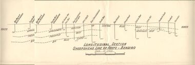 Bendigo Historical Society Inc.
Document - AUSTIN COLLECTION: SHEEPSHEAD LINE OF REEF PLAN
... the mines and their sites and depths, along the reef line. Reefs... plan of the Sheepshead line of reefs, showing the mines ...BHS CollectionLongitudinal plan of the Sheepshead line of reefs, showing the mines and their sites and depths, along the reef line. Reefs marked on plan: Central Blue Reef, Freehold Reef, Big Blue Slates, Central Clue Reef and Hercules Reef. From the south of the reef : Red, White & Blue Extended, South Blue Consolidated, Old Central Blue, True Blue, Blue consolidated South Shaft, No. 3 Shaft, Blue Consolidated, North Blue, Blue United, sheepshead, Central Blue, Little 180, Ironbark South, Ironbark, Hercules. Written on bottom of plan: ' Longitudinal Section Sheepshead Line of Reefs - Bendigo'.bendigo, mining, sheepshead reef -
 The Beechworth Burke Museum
Photograph - Photograph - Reproduction, c1920
... periods of mining, 1920s-1950s. Three Mile Mine was a major site... periods of mining, 1920s-1950s. Three Mile Mine was a major site ...This photograph depicts mining operations (in particular, hydrolic sluicing) at Three Mile Mine, Barramutha, during the later periods of mining, 1920s-1950s. Three Mile Mine was a major site of mining activity sating back to the 1850s, although was often not as prosperous as other sites such as those situated on the Woolshed Valley. Many miners would leave Three Mile Mine for better prospects on other claims. The main, most successful 'rush' at Three Mile Mine occurred during and immediately following September 1855. This photograph, however, depicts a much later period.The search for gold is ingrained into the history of Victoria and therefore, images like this one which portray a miner at a sluicing site can reveal important information for society and technology for the date when the photograph was taken. This image, and its related images, it important for its historical significant of labour and mining extraction used for gold during the latter gold rushes in the 1900s. The Beechworth Burke Museum has additional images relating to gold mining in the region which can be analysed and studied alongside images like this one.A black and white rectangular photograph printed on matte photographic paperreverse: 7597.4 / copied from original on loan from Webb (Qld) / Donated Nov 2009 / Baarmutha Three Mile Mine 1920-1950 / Owned by Plain Bros then Parkinsons / John Weir or Jack Cox / Sluicing /mining, barramutha, three mile mine, sluicing, mine, beechworth -
 The Beechworth Burke Museum
Postcard, c1900-1912
... ground. The Golden Bar site, mined by the Golden Bar Mining... ground. The Golden Bar site, mined by the Golden Bar Mining ...This object is a photographic postcard showing some of the above-ground structures of the Golden Bar mine in Chiltern, including a building with a smokestack and the poppet head which is used to haul equipment, materials, and men above or below ground. The Golden Bar site, mined by the Golden Bar Mining Company which was formed in 1901, managed to yield approximately 12,453 oz of gold before work stopped in 1912 - it was one of the principal mines in the area, as well as the deepest and one of the richest. The text on the postcard was handwritten by H.Gordon (?) to Issy (?), to show the mine where he presumably worked as he promises to take them 'above and below'. The postcard can be approximately dated to between 1901-1912. It is stated that after 1902 Kodak added the line on the postcard backs to divide into correspondence and address sections as seen on the reverse of this object. In addition, there is also a similar Kodak photographic postcard in the Burke Museum collection that is dated to 1908 and has the same specific font type and manufacturer markings (see references for link). Lastly, the Golden Bar mine ceased operations in 1912 so the photograph was likely taken prior to this. This photographic postcard is a rare and fair conditioned representation of one of the most significant gold mines in the Chiltern area, showing the above ground structures at the time it was being actively mined. This postcard also holds social significance as a snapshot of working life in the gold mining rush of Victoria, and a personal record of one of its miners. A sepia rectangular postcard printed on card.Obverse: Dudley Studio / Golden Bar. Chiltern Reverse: BMM 8034 / Post Card. / Correspondence. / Address Only. / Kodak. Austral. 110 / My Dear Issy (?), / A card only, to show (?) the mine / and when you come down I will / take you above and below, / All (...) love, me to. Has the baby / gone home yet Heini (?) wants to know / give my love to Syd when next you write / Your loving (...), H. Gordon (?)photographic postcard, postcard, chiltern, golden bar mine, golden bar mining company, dudley studio, kodak -
 The Beechworth Burke Museum
Photograph, 1857
... This photograph is of old mine workings on the site...-country This photograph is of old mine workings on the site ...This photograph is of old mine workings on the site of the Spring Creek diggings. Spring Creek is a contact zone for granite pluton and siltstones, shales and standstones; which has, over time, encouraged natural springs to form. Enriched with gold washed out of the surrounding granite, these alluvial deposits achieved fame from 1852 onwards as the Spring Creek Diggings sprang to life (not realised as geographically important until 1871). In Spring Creek that runs behind the main street of Beechworth, near the foot of Newtown Hill a pint pot of gold was discovered on one of these expeditions in 1852 by prospectors Baker and Strickland and the gold rush town of Spring Creek was formed. Australian gold rushes have always created a sense of independence and freedom; as do-it-yourself, off-grid, low-tech adventures. People of all backgrounds were drawn to the gold fields by the prospect of riches and adventure, but they also learned self-sufficiency and found freedom of expression. Industry boomed, new practices were adopted and social norms were upended. This image is of historical significance as it informs on the history of Australian gold mining. It represents the innovation that accompanied the mining industry and the importance of gold mining in town building and regional histories. Black and white rectangular photograph on unmounted board.gold mining, spring creek, mining, geography, geology -
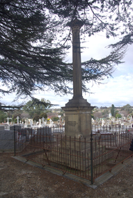 Ballarat Heritage Services
Photograph - Photograph - Colour, Burke and Wills Memorial at Bendigo Cemetery, 2018, 02/09/2018
... was quarried from New Chum Mine. The site in the Bendigo Cemetery... was quarried from New Chum Mine. The site in the Bendigo Cemetery ...Robert O'Hara Burke and Thomas Pope Besnard were childhood friends. As sexton of the local Back Creek Cemetery Thomas Besnard organised a subscription to raise the money for a monument to Burke, Wills and Gray. A subscription of one shilling, no more and not less, was asked so all subscribers were equal. The Bendigo monument was designed by Adam Duncan and features a Corinthian column mounted on a foundation stone, topped with a Grecian urn draped with the Union Jack. The stone for the monument was quarried from New Chum Mine. The site in the Bendigo Cemetery was selected by Besnard so the monument was on a grass knoll well clear of any other graves. The design included landscaping with a path and garden beds that provided dignified access. The Burke and Wills Monument in Bendigo has been entered on the Register of the National Estate as being important for its association with historical events and developments associated with exploration in the early days of Colony of Victoria. Two conifers remain from the original group sent by Mueller of the Melbourne Botanical Gardens to develop the garden layout on the knoll. These two trees are listed as Significant Trees by City of Greater Bendigo. The foundation block was laid on 20 August 1862 by Chairman of the Bendigo Municipality, Charles Burrows – exactly two years after the Expedition left Melbourne. A half day holiday was declared by Bendigo Council, and a procession left the Bendigo Town Hall and marched to the cemetery where 8000 people were gathered and another 4000 lined the route. John King was unable to attend due to ill health. Chairman of the Municipality of Bendigo, Charles Burrows, gave a long address, and diaries of members of the expedition, the Sandhurst Almanac, the Bendigo Advertiser, the Bendigo Independent Evening News, photographs of the deceased, photographs of Public Buildings in Bendigo, a Sydney half sovereign and all the silver coins of the Realm were wrapped in a Union Jack and placed in a niche in the foundation stone. Fifteen months later a column was erected on the foundation stone after Besnard openly criticised the Memorial Committee for their lack of action. The Bendigo Advertiser was disappointed at the location of the monument preferring a more central location and in 1893 an attempt was made to move the monument to Rosalind Park. On 19 May 1893, Mr Minto, the City Surveyor of the Bendigo MunicIpality reported it would cost £25, and no other action occurred. In 1940 the land around the memorial was sold off as grave sites and the paths and garden beds disappeared with graves now surrounding the base of the monument. The Burke and Wills Monument in Bendigo Cemetery was entered on the Register of the National Estate for its association with historical events and developments associated with exploration in the early days of Colony of Victoria. Two conifers remain from the original group sent by Mueller of the Melbourne Botanical Gardens to develop the garden layout on the knoll. These two trees are listed as Significant Trees by City of Greater Bendigo.Burke and Wills Memorial at Bendigo Cemetery, 2018Erected by the people of Bendigo in honor of the Victorian Explorers, Burke, Wills, Gray and King who first crossed the continent of Australia. King alone surviving the privation and suffering under which his three brave ill-fated companions sank. A.D. 1862. Robert O'Hara Burke, leader of the Victorian Expedition, left Melbounre 24th August 1860. Reached Carpentaria 12th Feby 1861. Died on his return at Coopers Creek, 30th June 1861. Charles Gray, died also on his return at Polygorum Swamp. 17th April 1861. William John Wills, second in command, died also near Coopers Creek, 29th June 1861. bendigo cemetery, burke and wills, burke and wills memorial, william john wills, john o'hara burke, charles gray, polygonum swamp, coopers creek, victorian expedition, carpentaria, bendigo public cemetery, bendigo remembrance park, thomas pope besnard -
 Federation University Historical Collection
Book, Ballarat School of Mines Council Minute Book, 1949-1956, 16/11/1949 - 04/10/1956
... Ballarat School of Mines Basketball site, 1953 Hickman Street..., 1956, p571 H.A. Patterson, 1956, p553 Ballarat School of Mines ...The Ballarat School of Mines was the first technical school in Australasia..1) Hard green covered book with part leather binding. Finance Committee, Council and one Christian Education (or chaplaincy) on sub-committee minutes Dr James Stewart, 1950, pp. 64, 138, 160 G. Baragwanath, carpenter, 1950 G.W. Barrell, 1950, p. 24 V. Belikov, 1950, p. 35 G.W. Cornell, 1950, pp. 37, 44, 78 R.M. Cutter, 1950 H. Edwards, 1950, pp. 14, 15 Arthur Gouday, 1950, p. 29 J.E. Hewitt, 1950, p. 119 D. Kellock, 1950, p. 117 H.H. Kerr, 1950, p. 74 L. Lederman, 1950, obituary, pp. 19, 28 A,W, Lynch, 1950, p. 24 D. Mullins (plumbing), 1950, pp 44, 78 A.M. Praetz, 1950, p. 95 Kevin White, 1950, p. 75 S.E. Williams, 1950 C.M. Chisholm, 1951 N.F. Dewsnap, 1951 F.A. Farr, 1951 R.P. Flower, 1951, p173 L. Garner, 1951, p128 Douglas R. Mills, 1951, p182 F.G. Proctor, 1951 A.J. Andreartha, 1952 B. Bryan, 1952 D. Cotton, 1952 D. Duggan, 1952 Hans Fumberger, 1952, p260, 287 V.C. Jones, 1952, p248 J.R. Lyall, 1952, p206 E.G. Savage, 1952, p228 Geoffrey F. Stevens, 1952 Albert Watts, 1952, p260 K.C. Webb, 1952, p248 Neon Signs, 1953, p310 William Baragwanath, 1953, p324 Ronald G. Barlyn, 1953, p314 C.M. King, 1953, p272 W. Murton, 1953, p340 F. Ritchie, 1953, p303 J. Turnbull, 1953, p274 J.R. Allsop, 1954 David Morris, 1954, p350 W.J. Paterson, 1954, p424 John Peyton, 1954, p348 William Sadler, 1954, p352 Mrs Connors, 1955 Corbould, 1955, p497, 503, 514, 521, 550 A. Causland, 1955, p507 W.W. Leggatt, 1955, p504 B.D. Ngip, 1955, p462 L.K. O'Down, 1955, p460 R. Rowlands, 1955, p508 J.A. Strange, 1955, p501 L. Wilson, 1955, p459 Harry Brew, 1956, p516 H.L. Coburn, 1956, p571 I.R. Gordon, 1956, p541 B.M. Hearn, 1956, p 550 John Miles, 1956, p571 H.A. Patterson, 1956, p553 Ballarat School of Mines Proposed Gymnasium (Corbould Recreation Hall) 364, 403, 445, 452, 458, 523, 531, 540 Ballarat School of Mines Museum, 1950, p38, 105, 112; Aboriginal Relics, P566 poliomyelitis, 1952 Ballarat School of Mines Agrostology, 1952, p242, 312, 360, 362, 370 Ballarat School of Mines Neon Sign, 1953 Ballarat School of Mines Basketball site, 1953 Hickman Street, Ballarat, Deviation near White Flat, 1954 Ballarat School of Mines Bicycle sheds, 1954 Ballarat Technical School, Norman Street, Ballarat, 1954 Ballarat North Technical School, 1956, p521 Ballarat School of Mines Christian Education, 1956, p569 Blacksmithing, 1956, p523 Ballarat School of Mines Museum Future, 1956, p526, 535, 536, 542, 561, 568 Ballarat School of Mines War Museum, 1956, p516, 542 Fossils, 1955, p462 123 grant Street purchase, 1956, p546 model Farm Smith gift, 1956, p561 Shearing, 1955, p504 Repatriation Students, 1856, p 555 .2) Typed and handwritten documents in plastic envelope at back of book on sundry topics.ballarat school of mines, ballarat school of mines council minutes, ballarat school of mines finance committee, ballarat school of mines christian education, chaplaincy, dr james stewart, g. baragwanath, g.w. barrell, v. belikov, g.w. cornell, r.m. cutter, h. edwards, arthur gouday, j.e. hewitt, d. kellock, h.h. kerr, l. lederman, d. mullins, a.m. praetz, kevin white, s.e. williams, c.m. chisholm, n.f. dewsnap, f.a. farr, r.p. flower, l. garner, douglas r. mills, f.g. proctor, a.j. andreartha, b. bryan, d. cotton, d. duggan, hans fumberger, v.c. jones, j.r. lyall, e.g. savage, geoffrey f. stevens, albert watts, k.c. webb, william baragwanath, ronald g. barylyn, c.m. king, w. murton, f. ritchie, j. turnbull, j.r. allsop, david morris, w.j. paterson, john peyton, william sadler, mrs connors, corbould, a. causland, w.w. leggatt, b.d. ngip, l.k. o'down, r. rowlands, j.a. strange, l. wilson, harry brew, h.l. coburn, i.r. gordon, b.m. hearn, john miles, h.a. patterson, ballarat school of mines gymnasium, corbould recreation hall, polio, poliomyelitis, a.j. andrewartha, pandemic, a.w. lynch, 123 grant street ballarat -
 Parks Victoria - Wilsons Promontory Lightstation
Stretcher
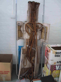
... . Industrial sites and mines are extremely dangerous work places.... Industrial sites and mines are extremely dangerous work places ...Made of canvas and bamboo slats with hemp ropes, adjustable canvas straps and metal buckles and rings, the rescue stretcher was used for carrying an injured person. According to the Powerhouse Museum, the stretcher and was ‘designed to support and carry an injured person in circumstances where the person has to be lifted vertically’. Known as the ‘Neil Robertson stretcher’, it was developed in the early 1900s by John Neil Robertson as a lightweight rescue device and was modelled on Japanese bamboo litters. An identical stretcher is held in Sydney’s Powerhouse Museum and is thought to date between c.1967 and 1999. The museum’s statement of significance for the unique stretcher elaborates on its cultural values: The canvas is wrapped around the patient and secured with strong canvas straps. A lifting rope is attached to a ring above the patient's head, while a guideline is tied near the ankles and used to stop the stretcher swaying as it is hoisted up. This style of stretcher was specifically designed for use on ships, where casualties might have to be lifted from engine-room spaces, holds and other compartments with access hatches too small for ordinary stretchers. The original name of the Neil Robertson stretcher was 'Hammock for hoisting wounded men from stokeholds and for use in ships whose ash hoists are 2 ft. 6 in. diameter'. Since those times the Neil Robertson stretcher has also been used in factories and mines and for other emergency rescue situations. It is still possible to buy this type of stretcher although the slats are now more likely to be made of wood. The example in the Powerhouse collection was amongst several items of obsolete first aid and rescue equipment donated by the electricity generation company Delta Electricity. It would have been used - or at least been on stand-by - at the company's Munmorah Power Station or the associated coal mine on the Central Coast of New South Wales. Industrial sites and mines are extremely dangerous work places. Throughout the 20th century to the present there has been a drive, especially in developed countries like Australia, to improve workplace safety. Measures taken to reduce injuries and deaths have included safer industrial equipment, safer work practices, staff training, and the ready availability of accident and emergency equipment.It was also used throughout WWI and WWII. There are two other examples of the stretcher are known in Parks Victoria heritage collections. Canvas and bamboo stretcher with straps and buckles. Hemp ropes are attached to the stretcher. -
 The Beechworth Burke Museum
Photograph
This photograph dates to 1899, towards the end of the gold rush in the Mopoke Gully area. A large opening to a mine can be seen behind the men in the photograph, with a wheeled cart on a track leading to the men's position, where the soil and rocks have been hauled away. This photograph interestingly contains dogs alongside the miners. While dogs have been recorded as deterrents to thieves in the Victorian goldfields, these dogs appear as companions to these men. Mopoke Gully mines came under the 'Fryer's Creek' division of the Castlemaine District during the Gold Rush. After the Gold Rush began in Victoria with the discovery of gold at Ballarat in 1851, Gold was found in Castlemaine by December of that year. 20,000 diggers were spread across the Castlemaine region, and the area was yielding about 23,000 ounces of gold per week. Mopoke Gully was the site of the Mopoke Gully Water Wheel, operating under the Bendigo and Fryers Goldmining Company from 1887 until 1900. This Water Wheel was used in the gold mining technique of 'sluicing'. Hydraulic sluicing uses high pressure water jets to blast away the earth, which runs through a sluice box, catching the gold with all remaining slurry washing away. This Water Wheel was built the same year as the more famous 'Chewton Water Wheel', but was smaller in diameter (60ft as opposed to Chewton's 72ft). The Mopoke Water Wheel ruins are quite intact today, and are a registered archaeological site. The search for gold is ingrained into the history of Victoria and therefore, images like this one can reveal important information for society and technology for the date when the photograph was taken. This image is of important historical significance for its ability to convey information about sluicing and the methods used to find gold in 1899. This photograph reveals important information on the use of dogs on Victorian goldfields in 1899. Dogs were used both as companions, such as this photograph depicts, as well as deterrents to thieves. Sepia coloured rectangular photograph printed on gloss photographic paper mounted on card. Obverse: Williams/ Good/ Luck Reverse: A02498/ 1997. 2498/ Good Luck/ Mine/ 1899/ Mopoke. beechworth, burke museum, gold, gold mining, 1899, castlemaine, mopoke gully, good luck mine, fryer's creek, gold rush, victorian gold rush, water wheel, sluicing, chewton -
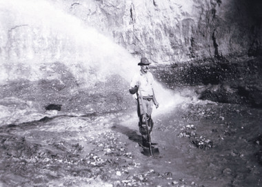
 The Beechworth Burke Museum
Photograph
This photograph dates to 1899, towards the end of the gold rush in the Mopoke Gully area. A slurry of rocks after they have been broken up is depicted, and this is part of the hydraulic sluicing mining process. Four men are relaxing under a wooden structure, with a fifth bearded man standing near a stone wall. This photograph interestingly contains dogs alongside the miners. While dogs have been recorded as deterrents to thieves in the Victorian goldfields, these dogs appear as companions to these men. Mopoke Gully mines came under the 'Fryer's Creek' division of the Castlemaine District during the Gold Rush. After the Gold Rush began in Victoria with the discovery of gold at Ballarat in 1851, Gold was found in Castlemaine by December of that year. 20,000 diggers were spread across the Castlemaine region, and the area was yielding about 23,000 ounces of gold per week. Mopoke Gully was the site of the Mopoke Gully Water Wheel, operating under the Bendigo and Fryers Goldmining Company from 1887 until 1900. This Water Wheel was used in the gold mining technique of 'sluicing'. Hydraulic sluicing uses high pressure water jets to blast away the earth, which runs through a sluice box, catching the gold with all remaining slurry washing away. Hydraulicking is the process of breaking up the rocks and suspending it in a slurry. This Water Wheel was built the same year as the more famous 'Chewton Water Wheel', but was smaller in diameter (60ft as opposed to Chewton's 72ft). The Mopoke Water Wheel ruins are quite intact today, and are a registered archaeological site.The search for gold is ingrained into the history of Victoria and therefore, images like this one which portray a sluicing site can reveal important information for society and technology for the date when the photograph was taken. This image is of important historical significance for its ability to convey information about sluicing and the methods used to find gold in 1899. It also shows a location where sluicing was undertook which provides insight into the impact of sluicing on the environment at a time when it was done. This photograph reveals important information on the use of dogs on Victorian goldfields in 1899. Dogs were used both as companions, such as this photograph depicts, as well as deterrents to thieves. Sepia coloured rectangular photograph printed on gloss photographic paper mounted on card.Obverse: Reverse: A02497/ 1997.2497/ 'Good/ Luck/ Mine'/ Morepork/ Gully/ Mrs Joyce/ Bright/ Tunnel/ 800 ft/ 1899. beechworth, burke museum, gold, gold mining, 1899, castlemaine, mopoke gully, good luck mine, fryer's creek, gold rush, victorian gold rush, water wheel, sluicing, chewton, slurry -
 The Beechworth Burke Museum
Photograph, est. 1860-1875
In 1875, the Rocky Mountain Extended Gold Sluicing Company Ltd was created, utilising the previous Rocky Mountain claim for the area near Lake Sambell. The company employed A.L Martin to survey an area for a tunnel underneath Beechworth and Johnson Stephens to dig it. The tunnel was built at a rate of 40 feet a month and eventually measured 800 metres. The tunnel was a true accomplishment both in the present and during the 19th century. It was considered to be a marvelous engineering feat. Beechworth is renowned for its hydraulic sluice method of mining. This involved soil being exposed to torrents of water from high-pressure hoses. From 1876 until its closure in 1921, the mine produced an astounding 47,926 ozs of gold. Companies like this were the source of income for many Chinese gold-diggers who sought to make their fortune on the goldfields of Beechworth. During the height of the rush, the town had around 7,000 Chinese inhabitants living on the outskirts of town as they were not permitted to live within Beechworth itself.The search for gold is ingrained into the history of Victoria and therefore, images like this one which portrays an open-cut sluicing site can reveal important information for society and technology for the date when the photograph was taken. This image is of important historical significance for its ability to convey information about sluicing and the methods used to find gold in 1910. It also shows a location where sluicing was undertaken which provides insight into the impact of sluicing on the environment at a time when it was done. This image of the Rocky Mountain mine is historically significant as the mining complex is now non-existent, with the only remains being the tunnel built in 1880 by the company, which was considered one of the greatest engineering feats of the time. The image also provides a first-hand look into the social and cultural networks at play during the 19th century with racial segregation of the Chinese at the 'Chinese Camp', as well as an insight into Beechworth's origins during the Gold Rush.A sepia rectangular photograph printed on matte photographic paper as a postcardReverse: Historic Beechworth / 7792.1 / ROCKY MOUNTAIN MINE / Viewed from the “Chinese Camp”, shown partly in the foreground, we see the central plant of the famous Rocky Mountain Mining Company. This extensive complex, of which nothing remains, was situated between Silver Creek and the present Lake Sambell area. The company was responsible for a tunnel cut through solid bedrock underneath the town of Beechworth and surfacing near the keystone bridge on the Wangaratta side. Completed in 1880 it was declared to be one of the greatest engineering feats in Australia. The tunnel is still basically intact today. / Series by Wooragee Graphics: Historic Beechworth. / COPYRIGHT BURKE MUSEUM / No.72 beechworth, rocky mountain mine, sluicing, gold rush, mining, gold