Showing 145 items matching "mullock"
-
 Bendigo Military Museum
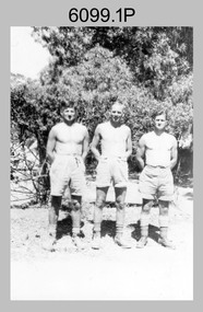
photograph - Fortuna - 1st Year of Army Occupation in Bendigo, 1942
This is a set of 17 photographs taken during the first year of Army occupation at Fortuna, Bendigo in 1942. The photos provide an insight into the preparatory work performed on the Fortuna Villa and surrounding buildings, by the Working Party 5th Army Troop and Ordnance Training Depot, before its occupation by personnel from LHQ Cartographic Company, Royal Australian Survey Corps. The annotation on the back of Photos .9P and .10P is misspelt. The correct spelling is ‘Nell Gwynne’. The poppet head of the Central Nell Gwynne mine is still an iconic landmark in Bendigo, lying just down the road from the poppet head lookout at Victoria Hill. The Central Nell Gwynne was the premier mine of Bendigo's 1930s mining revival and is of high historical value, due to the extensive and relatively intact features which remain at the site. The annotation on the back of Photo .17P is incorrect. The location of HQ 5th Army Troop was ‘Reynard St, Coburg.’ By late 1941 as Japan extended its control throughout Indo-China, resolving the accommodation problem of AHQ Cartographic Company located in Melbourne became more urgent. The steady Japanese advance made the bombing of Melbourne no longer a remote possibility, and in accordance with a general policy of dispersion, the Deputy Chief of the General Staff, Major General Sidney Rowell instructed Major William Sarll, in the interests of security of plant and to provide against possible damage of air attack, to investigate suitable safer inland accommodation for AHQ Cartographic Company. Major Sarll inspected many properties before finding one that would meet the requirements of the Cartographic Company. In late 1941, he came to inspect Fortuna, a rambling old mansion with about fifteen acres of ground in central Bendigo. Initially there was no intention to occupy the site beyond the end of the war, although Major Sarll's report to the Director of Survey noted many advantages in moving the Company to Bendigo. Major General Rowell quickly approved the selection of Fortuna before other authorities, which were investigating the evacuation of school children, could get in ahead of the Cartographic Company. On 23 March 1942, the Commonwealth of Australia, under the provisions of the National Security Act of 1939, took possession of the house, the old battery buildings and the fifteen acres of grounds. Under Warrant Officer J. Trist’s direction, over fifty Parks and Works tradesmen completed building works necessary to accommodate the Survey Corps’ military, map making and printing requirements. The building program was still under way when the first officer, Lieutenant Ralph Westgarth, arrived in May 1942 with the advance party which received and positioned all equipment as it came up from Melbourne in semi-trailers. Once the equipment was installed the rest of the Cartographic Company completed its shift to Bendigo by 11th June 1942. The first year of the Survey Corps’ occupation of Fortuna is covered in more detail with additional historic photographs, in pages 17-22 of Valerie Lovejoy’s book 'Mapmakers of Fortuna – A history of the Army Survey Regiment’ ISBN: 0-646-42120-4.This is a set of 17 photographs taken during the first year of Army Occupation at Fortuna, Bendigo in 1942. The black and white photographs were printed on photographic paper and are part of the Army Survey Regiment’s Collection. The photographs were scanned at 300 dpi. .1) - Photo, black & white, 1942. Bendigo Parks and Works tradesmen at Fortuna. L to R: Cliff Day, Ernie Arnold, Norm? .2) - Photo, black & white, 1942. “Don” - possibly SGT Don Sutcliffe. Fortuna, Bendigo. .3) - Photo, black & white, 1942. Parks and Works tradesmen in garden at Fortuna, Bendigo. L to R: Fred & Ernie. .4) - Photo, black & white, 1942. Benny Jack Williams at Fortuna, Bendigo. Accommodation tents were erected above the lake, which later became the parade ground. .5) - Photo, black & white, 1942. Working dress - Giggle suits. Parks and Works tradesmen at Fortuna, Bendigo. L to R: Cliff and Harry on big roof. .6) - Photo, black & white, 1942. Parks and Works tradesmen at Fortuna, Bendigo. Ted on big roof. .7) - Photo, black & white, 1942. Gold crusher battery just behind Fortuna. .8) - Photo, black & white, 1942. Scene of Bendigo from Fortuna. .9) - Photo, black & white, 1942. Nell Gwynne Mine from mullock heap at Victoria Hill near Fortuna, Bendigo. .10) - Photo, black & white, 1942. Nell Gwynne Mine and crusher near Fortuna, Bendigo. .11) - Photo, black & white, 1942. Sluicing for gold at Eaglehawk. .12) - Photo, black & white, 1942. Fortuna, Bendigo taken from the far side of tennis courts. .13) - Photo, black & white, 1942. Fortuna, Bendigo & its reflection from across the lake. .14) - Photo, black & white, 1942. Fortuna, Bendigo from the fishpond. .15) - Photo, black & white, 1942. Fortuna, Bendigo. .16) - Photo, black & white, 1942. First Fortuna Football Team at unknown location. L to R: 5th Bob Wright, 11th SGT Don Sutcliffe. .17) - Photo, black & white, 1942. Working Party from 5th Army Troop and Ordnance Training Depot at Fortuna, Bendigo.Some personnel are identified. Annotated with date within photos. .1) – Annotated on back ‘Cliff, Ernie, Norm, Dec ‘42. Cliff Day - dairy farmer, plasterers’ labourer. Ernie Arnold – hard plasterer. Norm? - QM Store for tools etc. QM Store was the Stables.’ .2) - Annotated on back ‘Don. Fortuna 1942’ .3) - Annotated on back ‘Fred & Ernie. Dec 1942. Carpenters. Note the state of the gardens.’ .4) - Annotated on back ‘Benny Jack Williams Fortuna Bendigo. Tents were erected where present day parade ground is above the lake.’ .5) - Annotated on back ‘Working dress - Giggle suits. June 42. Cliff and Harry on big roof. This photo was taken as the ventilating ridge was being installed on the building housing the printing machines. The machines were installed later by civilian labour when building was complete.’ .6) - Annotated on back ‘Ted on big roof Fortuna Bendigo.’ .7) - Annotated on back ‘Gold crusher battery – Bendigo for slay heap – 1942. 12 stamp battery. Just behind Fortuna. Was working at night when the “Army” came to Bendigo. Later removed to “Coolgardie - WA. Present site of Southern Cross TV.’ .8) - Annotated on back ‘Scene of Bendigo from Fortuna. June 1942.’ .9) - Annotated on back ‘Nell Gwyne Mine from mullock heap (Victoria Hill) Sept 1942.’ .10) - Annotated on back ‘Nell Gwyne Mine and crusher September 1942.’ .11) - Annotated on back ‘Sluicing for gold at Eaglehawk. August 1942.’ .12) - Annotated on back ‘Fortuna Bendigo 1942. Taken from far side of tennis courts.’ .13) - Annotated on back ‘ “Fortuna” across the lake & reflection.’ .14) - Annotated on back ‘Fortuna from fishpond June 1942.’ .15) - Annotated on back ‘Fortuna Dec 1942.’ .16) - Annotated on front ‘X’ x2. Annotated on back First Fortuna Football Team 1942‘Bob Wright’, ‘SGT Don Sutcliffe’. .17) - Annotated ‘Working Party at Fortuna before one of the drafts’, Working Party 5th Army Troop and Ordnance Training Depot Showgrounds, now the Sportsground Bendigo’, ‘HQ of 5th Army Troop was Reynards Rd, Coburg.’royal australian survey corps, rasvy, army survey regiment, army svy regt, fortuna, asr -
 Bendigo Historical Society Inc.
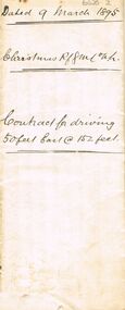
Document - CHRISTMAS REEF GOLD MINING CO COLLECTION: CONTRACT FOR DRIVING 50 FT EAST
Contract, 2 page handwritten, dated 9 March 1895, Written on front Christmas Reef GML Contract for driving 50 feet east @ 152 feet. On inside specification for driving cross-cut for the Christmas Reef Gold Mining Company No Liability ( least no 6486 Sandhurst ) at a depth of 150 feet A numbered list of expectation is given, for example Number 3: ' All Mullock & Co., obtained from the cross-cut shall be brought to the surface and the shaft and cross-cut left perfectly clear on the completion of the contract. Should any quartz be struck it must be brought up and stacked separately or disposed of as the company shall direct On bottom of contract I the undersigned hereby agree to perform the within mentioned work according to ?. Within written specification and to be bound by the terms and conditions therein mentioned for the sum of nine shilling and sixpence per completed foot of driving. Dated this ninth day of March 1895' signed Pat English. Below: My father the above named Pat English having died this morning, I am desirous of completing the above contract and I agree to complete the same according to the within written specification and to be bound by the terms and conditions therein mentioned for the sum of nine shillings and sixpence per completed foot of driving and to clean up the cross-cut to the presend and before starting. Dated this 29th. Day of March, 1895. Signed Patrick English.bendigo, mining, christmas reef gold mining -
 The Beechworth Burke Museum
Photograph - Photograph - Reproduction, Unknown
This image is a reproduction of an 1899 original depicting the 'Williams Good Luck Mine' on the Mopoke Reef (also called 'Morepork Gully') in the Dingle Ranges, approximately three miles from Beechworth. The foreground of the image is littered with piles of smashed rock and detritus, known as ‘mullock’, beside a reinforced mine shaft, a vertical access passageway allowing miners to enter the mine and haul ore out using lifting technology such as a poppet heads, whims or windlasses. A group of miners and a dog appear close to an open-sided miner’s hut. Following the discovery of gold at Beechworth in 1852, rushes quickly followed at surrounding creeks and gullies in the district. In the late nineteenth and early twentieth centuries, small syndicates of miners continued to work old or abandoned quartz reefs, often persisting without the assistance of heavy machinery to remove the large amounts of rock, in order to obtain yields at ever greater depths. The group of miners in this photograph are Mr. Roger Williams and Sons, who revived operations at the ‘Old Good Luck’ mine on the Mopoke Reef in the Dingle Range near Beechworth around 1892, working the site for more than two decades. An emigrant from Cornwall with experience in the tin mining industry, 19 year old Roger Williams senior sailed to New Zealand in 1840, then to Australia where he spent time in the Bendigo Gold Fields before settling in Beechworth in the early 1860s. Mr Williams senior worked on various mining activities in the district, including the Rocky Mountain Tunnel project. Conversant with the character of gold-bearing reefs in the area, the syndicate dug an eight hundred foot tunnel, digging down as far down as two hundred feet with little capital save their labour, to connect and provide better working access to the mass of reefs and veins in the vicinity. Progress was hampered by poor air quality charged with fumes from dynamite and large quantities of rock had to be crushed to obtain payable yields. The Victorian Goldfields are filled with ruins and remnants of the area's rich mining history, ranging from small alluvial diggings to the remains of huge mining companies. Site names often changed several times throughout the nineteenth and twentieth centuries. Some sites were abandoned and forgotten, others were worked continuously over many decades. The names of mines were often repeated at different locations throughout the Victorian Goldfields. For example, there is a Mopoke Gully heritage mine near Fryers Creek, Victoria. 'Mopoke' is a common onomatopoeic name for Morepork and Australian Boobook owls. This image has historical, social and research significance for patterns of emigration during of the Victorian Gold Rush, and the historical, social and environmental impacts of mining at Beechworth at the turn of the nineteenth and twentieth centuries. As gold became scarce and government support and large company investment waned, poor hard-working miners laboured intensively to make a living through periods of high unemployment. This image can be compared and studied alongside other historical mining photographs and objects in the Burke Museum Collection. It has potential to improve our understanding of miners working conditions and the shifting character of mining in the Beechworth district. Black and white rectangular reproduction photograph printed on matte photographic paper.Obverse: Williams Good Luck Mine Beechworth / Roger! / Reverse: 6858 / burke museum, beechworth museum, beechworth, gold fields, gold rush, victorian gold rush, gold ming history, colonial australia, australian gold rushes, mining technology, beechworth historic district, indigo gold trail, migration, indigo shire, good luck gold mine, victorian goldfields, mining syndicates, gold fever, quartz-mining, small-scale mining, old good luck mine, mopoke gully, quartz reefs beechworth -
 The Beechworth Burke Museum
Photograph
This image is a reproduction of an 1899 original depicting the 'Williams Good Luck Mine' on the Mopoke Reef (also called 'Morepork Gully') in the Dingle Ranges, approximately three miles from Beechworth. The foreground of the image is littered with piles of smashed rock and detritus, known as ‘mullock’, beside a reinforced mine shaft, a vertical access passageway allowing miners to enter the mine and haul ore out using lifting technology such as a poppet heads, whims or windlasses. A group of miners and a dog appear close to an open-sided miner’s hut. Following the discovery of gold at Beechworth in 1852, rushes quickly followed at surrounding creeks and gullies in the district. In the late nineteenth and early twentieth centuries, small syndicates of miners continued to work old or abandoned quartz reefs, often persisting without the assistance of heavy machinery to remove the large amounts of rock, in order to obtain yields at ever greater depths. The group of miners in this photograph are Mr. Roger Williams and Sons, who revived operations at the ‘Old Good Luck’ mine on the Mopoke Reef in the Dingle Range near Beechworth around 1892, working the site for more than two decades. An emigrant from Cornwall with experience in the tin mining industry, 19 year old Roger Williams senior sailed to New Zealand in 1840, then to Australia where he spent time in the Bendigo Gold Fields before settling in Beechworth in the early 1860s. Mr Williams senior worked on various mining activities in the district, including the Rocky Mountain Tunnel project. Conversant with the character of gold-bearing reefs in the area, the syndicate dug an eight hundred foot tunnel, digging down as far down as two hundred feet with little capital save their labour, to connect and provide better working access to the mass of reefs and veins in the vicinity. Progress was hampered by poor air quality charged with fumes from dynamite and large quantities of rock had to be crushed to obtain payable yields. The Victorian Goldfields are filled with ruins and remnants of the area's rich mining history, ranging from small alluvial diggings to the remains of huge mining companies. Site names often changed several times throughout the nineteenth and twentieth centuries. Some sites were abandoned and forgotten, others were worked continuously over many decades. The names of mines were often repeated at different locations throughout the Victorian Goldfields. For example, there is a Mopoke Gully heritage mine near Fryers Creek, Victoria. 'Mopoke' is a common onomatopoeic name for Morepork and Australian Boobook owls.This image has historical, social and research significance for patterns of emigration during of the Victorian Gold Rush, and the historical, social and environmental impacts of mining at Beechworth at the turn of the nineteenth and twentieth centuries. As gold became scarce and government support and large company investment waned, poor hard-working miners laboured intensively to make a living through periods of high unemployment. This image can be compared and studied alongside other historical mining photographs and objects in the Burke Museum Collection. It has potential to improve our understanding of miners working conditions and the shifting character of mining in the Beechworth district.Sepia coloured rectangular photograph printed on gloss photographic paper mounted on card.Obverse: Reverse: A02497/ 1997.2497/ 'Good/ Luck/ Mine'/ Morepork/ Gully/ Mrs Joyce/ Bright/ Tunnel/ 800 ft/ 1899. burke museum, beechworth museum, beechworth, gold fields, gold rush, victorian gold rush, gold ming history, colonial australia, australian gold rushes, mining technology, beechworth historic district, indigo gold trail, migration, indigo shire, good luck gold mine, victorian goldfields, mining syndicates, gold fever, quartz-mining, small-scale mining, old good luck mine, mopoke gully, quartz reefs beechworth -
 Bendigo Historical Society Inc.
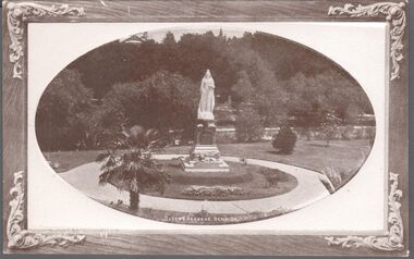
Postcard - BENDIGO POSTCARDS x 5
Five sepia postcards of Bendigo - St. Paul's Church, Bendigo; Queen's Reserve, Bendigo; St. Andrew's Presbyterian Church and School, Bendigo; The Orphanage, Bendigo; and Conservatory Gardens, Bendigo. 'C & L Series' and 'Semco Series', Bendigo. Early 1900's. Unused, and no writing on the reverse of the postcards. May have been connected with the Waterworth family. St. Paul's Church: St Paul's Cathedral, Bendigo was built in stages. The nave was built in 1868, the tower in 1872-73 and the transepts and sanctuary in 1926-27. Robert Love was the architect, although the final stage was supervised by architects Gawler and Drummond. Cathedral status was transferred from the original cathedral All Saints to St Paul's in 1981. The Gothic style cathedral is constructed of red brick with stone dressings. It has a simple cruciform plan comprising a six bay nave, transepts and sanctuary. A tall tower centrally located at the west end dominates the exterior. The peal of eight bells was cast by Meares and Co of London and installed in 1873. The interior features elaborately cusped roof principals; an organ by Alfred Fuller built in 1883 with a console and pipes added later from St Andrew's Cathedral, Sydney; and notable stained glass by Ferguson, Urie and Lyon. St Paul's Rectory was built in 1885 to a design by the architect W C Vahland. The Parish Office and Hall was built as a Sunday School in 1898 to a design by F W Lehmann. Queen's Reserve: Now known as part of the Bendigo Botanic Gardens, Rosalind Park, Pall Mall. In 1851, the gold rush transformed the area and eventually the mullock heaps became the most prominent public park in Bendigo. Rosalind Park was added to the Victorian Heritage Register in 2000 for its historic, archaeological, aesthetic, scientific (botanical) and architectural significance to the state of Victoria. The statue of Queen Victoria dates to 1903. St. Andrew's Presbyterian Church: Opened in 1859 as part of the Presbyterian Church, St. Andrew's. Union of the Presbyterian, Methodist and Congregational Churches in 1977 saw this church join the Uniting Church. Located in Myers Street, Bendigo. The Orphanage: The Convent of the Good Shepherd, Bendigo was established in 1905. It was established at the request of the Bishop to cater for children in the diocese of Bendigo (although it housed children from other areas as well). It was also known as St Aidan’s Orphanage, and was the only Good Shepherd Convent in Australia to care for boys. The section named St Aidan’s accommodated girls aged up to around 16 years, as well as boys aged up to around 11. Maryfields housed girls and women aged from around 15 years. The Convent ceased to operate as a residential facility for children in 1981. A number of women with disabilities remained at the Convent until it closed in 1984. Conservatory Gardens: Now known as part of the Bendigo Botanic Gardens, Rosalind Park, Pall Mall. In 1851, the gold rush transformed the area and eventually the mullock heaps became the most prominent public park in Bendigo. Rosalind Park was added to the Victorian Heritage Register in 2000 for its historic, archaeological, aesthetic, scientific (botanical) and architectural significance to the state of Victoria. The Conservatory Gardens feature an ornate 19th century Conservatory building, erected in 1897 - this was the last building of its type in a public park in Victoria. bendigo, gardens, buildings, chinese, church -
 Bendigo Historical Society Inc.
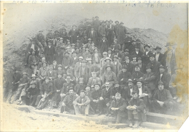
Photograph - PURDY COLLECTION: NEW RED WHITE AND BLUE/NORTH BLUE 2, 3 BLUE MINES
Black and white image - very faded - of miners from the New Red White and Blue Mine, and North Deborah Mine. Men are standing in front of large mullock heaps, sitting in front and standing on slope of mullock heap behind. Very large group of men dressed in working clothes. On top of image in biro New Red, White and Blue North Blue, 2 and 3 Blue, 1923 On back of image: written in biro are names of men. New Red White and Blue Consolidated Mining Co., North Red White and Blue No. 2 north of main shaft, No. 3 Blue, south of main shaft, Quart Hill, Adams Road. Names of miners written in back in pen: (no order given) New Red, White and Blue Consolidated Mining Co., North Red, White and Blue No 2 north of main shaft, No 3 Blue South of Main Shaft, Quartz Hill, Adams Road, (Golden Square). Mine managers: W Brimacombe, Fred Woods, Bob O'Brien, John Saunders, George Kinsgley, Jim Arthur, Bill Bren, Charle Cheetham, Tom Rowe (Snr), Grimshaw Hayes. Underground managers - shift bosses Bill Crosman, Steve Rothenberger, Tom Turner, Jim Chapman, Snowy Read, Jim Poole, J Champman, Bil Leggo, Gus Vlaminck, Biven Shelton, Ted Connors. (Photo) Phil Lanyon, Jack Plant, Jim Plant, Tom Turner, Tom Rowe (Sen) Bob O'Brien, Jim Buller, Arthur Webster, C. Neeman, Jack Craven, Peter Millar, Engine Driver Fred Watson, P Hopley, Jim Purdy, Jack Bottom, George Ross, Dave Rigbye, Gill Dupey, Fred Smith, Er Smith, Dick Plowright, Charlie Rickards, H. Stevenson, Sal Smith, Bill Harris, Frank Greig, C. Reid, Bill Leggo, Jim Poole, George Moore, W. Webb, Windy Hurst Shaft repairing: Harry Shelton, Bil Beveridge, Ted Porter, Joe? Harry Pollard, W. Polglase, Dave Lyke, Bill Del, W. Boland, Jack Hosking, Polshaw, Pomp Davidson, Jim Lesley, Dan Scully, Cliff Barton, George Barton, Tom Crowther, Bill?, Jack Hosking, Ern Rushmeyer, George Hocking, W. Benbow, Joe Hocking, Jim Jose, Jack Jose, Herb Bill, Dick Arthur, Taff Hocking, Charlie Dean, pat Doyle, Peter Doyle, Bob Davey, Roger Trewarne, Wilf Watson, Bill Hatfield, Dick Lanyon, Hughie Atherton, Ashley Rigbye, John Purdy, Bill Watson, Jim Watson, Perce Johnson, Russ Champan, W. McNamara, W. Nievandt, E. Jobe, Bill Yates, Yate McBeth, Alex Eadie, Jim Eadie, Jorgensens, Leo Atherton, Ted Comners, 2 Battery: Mears, Bill Dewar, Dave Luke, Allan Arthur. Deutchman, Les Balle, Perce Balle, Bob Hunter, Ray Jackson, Cec Waterman, George Randall, Ted Porter, Yate McBeth, W. Lamont, D. Rigbye, J. Purdy Platman North Blue 14 years (7.7.1920 - 1.11.1940) Engine Drivers: Fred Watson, Jack Plant, Harry Hanson, Anthony Hall, Jack Botton, Harry Nicholas, John Teasdale.bendigo, mining, red white and blue -
 Ballarat Heritage Services
Photograph - Photograph - Colour, Clare Gervasoni, Nimon's Bridge, 1999, 04/10/1999
Nimons Bridge was built in 1890, as part of the then Ballarat-Linton railway. The bridge is 17 spans with tall timber piers of four driven piles each, with triple sets of diagonal cross-bracing and walers and a single row of longitudinal horizontal bracing between piers. The spans are of a uniform twenty feet (6.1 metres), originally supported by four 21-inch x 9-inch (535 mm x 230 mm) Kauri timber beams per span, following the standard V.R. design of the period. When the superstructure was rebuilt after the 1953 fire, the timber beams were replaced with two 24-inch (610mm) deep rolled-steel-joists on each span. These are marked 'Lancashire Steel Co., Scotland' and are believed to have been second-hand. The deck of transverse-timber planks is 103.6 metres in length. Overall the bridge has an impressive appearance with its exceptionally tall triple-cross-braced piers creating a 'three-tiered' effect, with the deck 19.2 metres above the Woady Yaloak River. The Ballarat-Skipton line closed in 1985. Nimons Bridge has been recently restored, as part of the Ballarat-Skipton Rail Trail. How is it significant? Nimons Bridge is significant for technical, historic and aesthetic reasons at a State level. Why is it significant? Nimons Bridge is technically significant as Victoria's fourth-tallest timber trestle bridge when built, and as the third-tallest surviving example. It is also the second-largest composite bridge combining traditional timber piers with RSJ spans and a timber deck and falls within a select group of fewer than ten timber railway bridges with horizontal longitudinal bracing between the piers and three sets of double cross-bracing on its tallest piers, creating a visually striking 'three tiered' effect that enhances its viaduct form. Nimons Bridge is historically significant as having served initially the mining community at Linton, then the Western District agricultural area and in later years a kaolin quarry at Pittong. Nimons Bridge is historically significant as a representative of the 'light' branch line methodology that stimulated the explosion of railway construction in Victoria during the 1880s, and provides an interesting contrast with the more solid and vastly more expensive railway viaducts built in similar terrain on Victorian main lines, at Moorabool and Taradale, in the late 1850s. Approached by a deep cutting and high embankment at either end, the bridge represents a very cost-effective late 19th century engineering solution to the characteristic physiography of western Victoria with flat basalt plains intersected by deep wide valleys occasionally subject to severe flooding. Nimons Bridge is aesthetically significant for its visually impressive viaduct form, crossing a deep and steep-sided valley that is part of a rich cultural landscape. Within close proximity of the bridge are mullock dumps, tailings, shaft sites and other relics of the deep-lead alluvial mining era. The bridge is the most visually spectacular timber-trestle rail bridge in Western Victoria and is among the most spectacular timber-trestle rail bridges surviving anywhere in Victoria. It is part of the Ballarat-Skipton Rail Trail. Classified by the National Trust :02/10/2000 (http://vhd.heritagecouncil.vic.gov.au/places/67986)Colour photograph of a log bridge known as Nimon's Bridge.ballarat-linton, nimons bridge, nimon's bridge, log bridge, viaduct, timber-trestle rail bridge -
 Bendigo Historical Society Inc.
Photograph - MINING IN BENDIGO COLLECTION: MINING PHOTOGRAPHS
BHS CollectionFolded paper with copies of photos of mines and various mining buildings. On the front is a view from New Chum Hill, looking south in 1890's. Pictured is the Lazarus Crushing Plant and boiler house, Lansell's '222'. Amd the new Chum Mines in the background. On the inside at the top is the New Chum Railway, Golden Square. Pictured is the mine and its buildings, two chimneys, two large wood stacks and other mines in the background. On the left, a man is standing on the side of the railway line beside the mine. The next picture is the United Hustlers and Redan Mine, west of Comet Hill State School, Sandhurst Road. It shows the mine and its buildings, chimney, ore bins, mullock heap and tramway. The middle picture is the Central Deborah, Violet Street, near Bendigo Creek, Golden Square. It shows the poppet legs, buildings and some machinery behind the large building. The large building has eight ventilators in the roof. The buildings are made of corrugated iron. The bottom left picture is the Deborah Mine, Quarry Hill. The picture shows the poppet legs on the hilltop, the buildings beside it, a square chimney behind the poppet legs and some vegetation and a peppercorn tree in the foreground. The far building also has ventilators in the roof. The picture on the right is underground at 1000 feet level in the Deborah Mine. Pictured are three men with a rock drill. On the back, at the top is a picture of a First Motion Winding Engine at Deborah - later at Central Deborah. The picture shows the engine and driver. The middle picture is the South New Moon Mine, Eaglehawk - leading mine in State in 1903. The picture shows the poppet legs, buildings, chimney and a high tramway. In the foreground is a dam. The bottom picture is Victoria Hill looking south to New Chum Hill. In the foreground is Lansell's '180' Mine and Ballerstedt's Open Cut and in the background are the 'New Chum and Victoria', 'Old Chum' and the 'North Old Chum'.photo, mining in bendigo, mining photographs, lazarus crushing plant, lansell's 222, new chum mines, new chum railway, united hustlers and redan mine, comet hill state school, central deborah, deborah mine, first motion winding engine, south new moon mine, lansell's 180, ballerstedt's open cut, new chum and victoria, old chum, north old chum, square chimney -
 Bendigo Historical Society Inc.
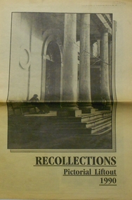
Newspaper - PETER ELLIS COLLECTION: RECOLLECTIONS PICTORIAL LIFTOUT
Historical lift out. Newspaper. Titled RECOLLECTIONS Pictorial Lift out 1990.1 looking down Mitchell St. from Railway Bridge. 2 Original railway station viewed from Mitchell St. bridge. 3 The great extended Hustlers mine. 4 1873 photo recently extended town hall with corn exchange at front left. 5 looking north westerly from city rec reserve at royal hustlers. 6 children play on mullock heap in front of a view of westerly quarter of Sandhurst. 7 Bank of Victoria, Mitchell St. left is Bendigo's original post office. 8 Looking down from what is now Rosalind Park. Shamrock Hotel can be seen on corner of Williamson St. and Pall Mall. This photo predates the construction of post office and law courts. 9 girl eating fairy floss. 10 4 kids on 1 horse in procession. 11 monkey and pedal car, a novelty attraction 1940's. 12 pony rides. 13 flying horses (ride). 14 processions past city hall. 15 Original ANZ bank corner Williamson St. & Pall Mall. 16 Chinese Dragons Bendigo Easter Fair 1940's. 17 City Hall viewed from Bull St. 18 City Hall original ceiling. 19 new town hall 1861. Mike Butcher, local historian. 21 Interior plan of city hall (ground floor) 22 circa 1920's 23 Tattered fragment original architect's drawing. 24 original assembly room. 25 Camp Hill PS Shamrock hotel without top story 27 shop with signage advertising Bushells, Bex and Swallow's Biscuits. 28 View from where fountain is now. 29 Hargreaves St. Looking south, now Hargreaves mall. Horse drawn water tank watering down road. 30 Central Deborah Gold mine poppet head. 31 Borough town hall, tram ways. 32 Original ANZ Bank corner Williamson St. and Pall Mall, demolished in mid 1960's. 33 Bush's store corner Williamson and Myer streets.34 Men on boat, don't know what or where. 35 Shearers. 36 men on a three wheeled bike. 37 4 Gold miners with shovels. 38 6pm closing, no trade Sundays, no women in main bar. 39 Peaceful scene Castlemaine 1940's Photographer Alan Doney. 40 Qantas Jet the City of Bendigo Tullamarine Airport. BCV-8 camera man & Advertiser photographer. 41 Ladies. 42 Tennis -> men and women (women in hats). 43 Sandhurst footy team. 44 Early school photos.bendigo, history, photographic history -
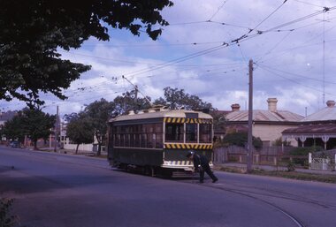 Ballarat Tramway Museum
Slide - 35mm slide/s, Noel Simons, 21/11/1962 12:00:00 AM
Set of 17 transparencies taken on 21/11/1962 on Kodak mounts. 1188.1 - Bendigo No. 11 at Depot Junction McCrae and Arnold St. with driver/conductor changing points. 1188.2 - Bendigo No. 4 at Charing Cross, side on photo, with City Club Hotel and Alexandra Fountain in the background. Tram has Castrol and SEC 'Electric Cooking' ads. 1188.3 - Bendigo No. 4 climbing View St. after tram has passed photographer. Tram has Streets Ice Cream and Cohns Soft Drinks ad on rear dash panel. In the background are the buildings in View St., including the Princess Theatre. Tram has destination of Eaglehawk. 1188.4 - Trams 2 and 4 crossing at the California Gully or Thorpe St Loop. 1188.5 - Bendigo 4 in Mt Korong Road. Tram inbound with destination of Quarry Hill, just leaving Garden Gully Loop. 1188.6 - Bendigo 4 and 17 crossing at the Hayes St. or Iron Bark Gully Loop. No. 17 bound for Eaglehawk, No. 4, Quarry Hill. 17 has two SEC roof ads and a white horse whiskey ad. 1188.7 - No. 17 bound for Eaglehawk, soon after leaving California Gully. Has large mullock heap in background. 1188.8 - Bendigo 2 and 17 crossing at the Thorpe St. or California Gully Loop. Has butchers shop in background. 1188.9 - Bendigo 17 at the Eaglehawk terminus. Has destination of Quarry Hill. In background is the hotel and shops at the terminus, showing ads for "Melbourne Bitter". Tram has two SEC 'Electric Cooking' ads. Driver and conductor about to assist two lady passengers with a pram and baby. 1188.10 - No. 17 at Eaglehawk terminus, awaiting departure. Has Eaglehawk Town Hall and Post Office in background. Tram has a Whitehorse Whiskey ad on the front dash panel. 1188.11 - No. 3 in High St. Eaglehawk, with destination of Eaglehawk. Has the shops on the south side of High St. in the background, including the Eaglehawk fish shop. Tram has two roof ads, one an SEC roof ad, and Cohns Drinks and Streets Ice cream ads on front dash panel. 1188.12 - as above, but after tram has passed photographer. Note the centre of the road poles. 1188.13 - No. 2 outbound for Eaglehawk at the intersection of Mt. Korong Road and the Calder Highway. Photo taken after the tram has passed the photographer. Has an Ampol service station in the background. 1188.14 - No. 11 leaving the Bendigo depot, crossing the bridge, with the Scrubber car in the background. 1188.15 - No. 21 at the North Bendigo terminus. Tram has destination of Golden Square and Cohns drink ad on front dash and two roof ads on side. 1188.16 - No. 11 on Golden Square route, in High St. at intersection with Old High St. 1188.17 - No. 11 at the Golden Square terminus, conductor turning the pole. Hotel on the left side of the photo. Note the road works barrier and red flag behind the tram. Slide has an end of roll mark on the right hand side of the image.Information written on in black ink and date stamped on purple ink. 1188.1 - "Birney car No. 11 in McCrae St. at Cnr of Arnold about to run into depot, Bendigo" 1188.2 - "No. 4 at Alexandra Fountain, Charing Cross Bendigo" 1188.3 - "No. 4 climbing the View St. Hill from Charing Cross, Bendigo (Eaglehawk Route)" 1188.4 - "No. 4 and 2 at Thorpe St. Loop, California Gully" 1188.5 - "No. 4 in Mt Korong Rd., Long Gully, Near Havilah Rd. (Bendigo) (Eaglehawk Route)" 1188.6 - "Nos. 17 and 4 crossing on Hayes St. Loop, Ironbark, Bendigo" 1188.7 - "No. 17 soon after leaving California Gully (Eaglehawk Route)" 1188.8 - "No.2 and 17 crossing on Thorpe St. Loop, California Gully (Eaglehawk Route)" 1188.9 - "No. 17 at Eaglehawk terminus" 1188.10 - "No. 17 at Eaglehawk terminus" 1188.11 - "No. 3 in High St. Eaglehawk" 1188.12 - "No. 3 nearing Eaglehawk terminus" 1188.13 - "No. 2 in Mt. Korong Rd., Ironbark. Calder highway on left (Eaglehawk route) 1188.14 - "Birney car No. 11 leaving Bendigo depot. Scrubber car at rear" 1188.15 - "No. 21 at North Bendigo Terminus" 1188.16 - "Birney car No. 11 in High St. Bendigo at intersection with Old High Street (Golden Square Route)" 1188.17 - "Birney Car No. 11 at Golden Square terminus, High St., Bendigo". tramways, trams, bendigo, depot junction, charing cross, view st., eaglehawk, north bendigo, golden square, tram 2, tram 3, tram 4, tram 11, tram 17, tram 21, tram scrubber -
 Bendigo Historical Society Inc.
Document - Hustlers, Sheepshead and Deborah lines of reef
Albert Richardson was a mining historian who wrote widely on the mines of the Bendigo Goldfield. The park opposite the Goldmines Hotel in Marong Road, is named in his honour. Five page document, hand written by Albert Richardson on lined foolscap and edited with cross-outs and insertions, . The mines along the Hustlers line of reef and the Sheepshead line of reef are described. Mines listed on Hustlers line of reef: Fortuna Hustlers (1888 - 1913), shaft 2,240 feet at rear of Buckell and Jeffrey's offices; Royal Hustlers Reserve No. 2 - two shafts 'City" 860 feet, now covered by R.S.L. building Pall Mall, steel poppet legs 60 ft high and 'Park Shaft" at rear of Camp Hill School, 1,775 feet, steel poppet legs 60 feet high; Hustlers Hill Group first worked by Jonathan Harris in 1853 and bounded by Valentine, Anderson and Ironbark Creek to the north and Milroy Street to the east, one of first areas worked for quartz reefing. It with Garden Gully line west and Victoria Hill Ironbark, formed by far the richest cross section of the Bendigo Goldfield. Great Extended Hustlers (1865-1921) close to intersection of Anderson Street and Hustlers Road, mullock heap against road and shored up around shaft, steel poppet legs now at Wattle Gully mine, Chewton, large winding machine, air compressor south of shaft and 36 head crushing battery. Hustlers Reef (Old Hustlers) and Hustlers Reef No. 1, two shafts, main 2,210 feet, about 220 yards east of Moran Street and against Fenton Street. , No. 1 shaft 1,140 feet and about 155 yards east of Moran Street. Lansell's Comet, Lightining Hill line, 2.100 feet, on Comet Hill approx 70 yards west of Holmes Road, near Comet Creek, steel poppet legs. United Hustlers and Redan (1876-1918), main Redan, 1,830 feet about 155 yards west of Sandhurst Roead, in line with Comet Hill State School, this hill known as Redan Hill. North, or New Hustlers, once known as Agnew Hustlers, wooden poppet legs, south side, Kneebone Street, Eaglehawk. Derby line, Johnson's No. 3, South Johnson's (east shaft of Collman and Tacchi) 439 feet on west wide of Woods Street, south of Wetherall Street. Paddy's Gully Line, south to north, some shafts - Lansell's 'Sandhurst" ('Needle") Eaglehawk Road shaft 2,425 feet, about 50 yards east of Needle Loops, a brick square sided chimney with Cleopatra Needle top. British American, 789 feet, just south of Holdsworth Road. Collman and Tacchi, main shaft 2,588 feet, 60 yards west of Eaglehawk Road, California Gully. Deborah Line of Reef, The Deborah (1932-1954) shaft 2.017 feet, west of Adams Road and south of Abel Street, Quarry Hill. North Deborah (1937 - 1954) shaft 1,151 feet, Breen Street, Quarry Hill, steel poppet legs. Central Deborah (1939-1954) shaft 1,347 feet Sheepshead line of reef, Lansell's South Red, White and Blue, shaft 2,124 feet, north east of Bellevue Road and 220 yards east of Adams Road. The New Red, White and Blue Consolidated (Big Blue) main shaft 2,416 feet. Lansell's Bendigo Battery 105 head, north of 'Big Blue" on his freehold lease, commenced crushing on 24th February 1895. After closing was erected as the Showground's Industrial Hall, July 1926. North Red, White and Blue, burnt down February 1926, new company 1934, closed 1938. Document is part of the Albert Richardson Collection of Bendigo mining history. bendigo, gold mining, deborah line of reef, sheepshead line of reef, hustlers line of reef, royal hustlers reserve mine, hustlers hill group of mines, great extended hustlers, hustlers reef no. 1, lightning hill line, old comet, collman and tacchi, lansell's comet, north deborah, central deborah, dhrrpdhrsf linr og trrg, new red, white and blue consolidated mine, big blue, lansell's bendigo battery, north red, white and blue mine, albert richardson collection -
 Federation University Historical Collection
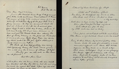
Letter, Letters from Richard Squire to his son Tom 1934
In 1905 Richard Squire was manager of the West Berry Consols at Allendale, and developed an improved system of mine ventilation, which was supported in "The Age."[4] He was successful in combating and remedying the gas and ventilation troubles of the Deep Mines of Creswick and Allendale Districts after all had failed.[5] MINE MANAGERS’ ASSOCIATION. Ballarat Branch. ... Mr R. B. Squire, manager of the West Berry Consols, at Allendale, submitted a paper detailing what he had done tor the betterment of ventilation in the alluvial mines of Smeaton and Mary borough districts- Members gave Mr Squire every credit for the results that he claimed to have effected; the adoption of his ideas had testified to their value to mine-owners. It was painted out, however, that for want of a thorough debate of the subject with experienced men the author had unwittingly included some general statements that required modifying in some points and extending in others, in justice to other workers among the earlier and the present day managers of mines. It was decided to invite the author to meet a sub-committee on this subject![6]Handwritten letters from Richard Squire to his son Tom and Family reporting happening at the mine richard squire, tom squire, engine trouble, basil, f.l. smythe broker, trembath, w. ryall, mt mercer, flu, plant, skids, pump, c. hayes, illness, poppet, carburetor, mum, ned, shaft, balance weight, hazel squire, pearson, pulleys, syndicate, goon, len hopkins, suction, dunstown, lease, jim squire, bannockburn, nina, albert, mrs trenery, connie, jay, judy squire, cohuna, bladder attack, reports, estimates, dunstan & coy, jelbarts, barrett, flat fields, brown, gold estates, berry leads, parsley roots, share book, meredith, reef, pay sheet, colin, mr gibbs, l.r.g plan, banagwanth, mcnaughton bores, glenfine, allan, william thomas, john lynch, crawford, shelford, liz the car, trucks, chandlers, ballarat trustees, cameron, elaine, mrs read, clark, j. hayes, dunlop, dr lawrence, eye specialist, reid, mullock bank, jack squire, herman, peter's legal inc. ballarat, freddie reid, j.r. whipp, a.b. reid, grenville, leigh river plan, johnstone's, premier petrol coy, chandler's, ballarat deep leads extension, harwood & pincott, a. rice, lillas, l. e. walker, secretary for mines, pipeclay, sandstone, mr saville, weymouth & carroll, suction pipe, valves, financiers, gold mines of australia, mr hanley hunter, sadowa coy, kerang shareholder, buninyong, stanley hunter, len, fran, max, dr jones, honeycomb rock, booth, sandy mcnab, emily shaw, john cock, ross creek, mitchell, rowe, neil cameron, walker, kidney disease, holst, nellie, ronaldson's, ronaldson & tippett, brokers, investors, lockett, miller & co, wellesly, john sharpe, elizabeht ellen, old lawaluk, mining -
Federation University Historical Collection
Book, Historic Sites Survey: North Central Study Area, 1979, 1979
The North Central Study Area included the Shires of Avoca, Bet Bet, east Loddon, Goulburn, Untly, Kara Kara, Korong, Maldon, Marong, Metcalfe, McIvor, Newstead, Strathfieldsaye, Stawell, Talbot, Clunes, Tullaroop and Waranga. 153 page book with white plastic binding. It is an historic sites survey for the North Central Study Area commissioned by the Land Conservation Council, the Ministry for COnservation and the Australian Heritage Commission. castlemaine, mount alexander goldfield, maldon, percydale, warrenmang, moliagul, tarnagulla, stuart mill, the whipstick, whroo, rushworth, graytown ironbark forest, st arnoaud, new bendigo, landsborough, inglewood, kurting, wedderburn, wehla, kooroora, langham flat, mcintyre, rheola, diamond hill, fosterville, coliban water works, green gully, newstead, muckleford forest, costerfield, graytown, bailieston, waranga irrigaiton system, eucalyptus distillery, mia mia bridge, korokubeal township researce, concegella slate quarry, chewton, fryerstown, kingower, timor, talbot, majorca, carisbroook, clunes, st arnaud, taradale, icomos, dunolly, limestone, castlemaine slate quarry, harcourt granite, taradale railway viaduct, loddon united waterworks trust, gouldburn weir, carisbrook lock-up, history of tree planting in streets, history of public reserves, r.u. nicholls nurseryman, thomas lang, francis moss, ballarat botanical gardens, ballarat school of mines botanical gardens, lake wendouree, victoria park, ballarat, muont holled smith, ballaarat old cemetery planting, eastern oval, ballarat east botanical gardens, ballarat east town hall gardens, eureka stockade reserve, ballarat observatory plantings, yarrowee creek plantings, yarrowee bluestone channels, ballarat woollen mill, band and albion mullock heap, black hill plantings, yarrowee creek channels, canadian creek channel, specimen vale channel, poverty point reserve, union jack reserve buninyong, imperial mine, buninyong, victoria street plantings, bridge mall, sturt street gardens, ballarat avenue of honour plantings, white flat oval plantings, camp street, elms, burnt creek -
 Federation University Historical Collection
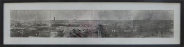
Photograph - Photograph - Black and White, Ballarat, c1858, c1858
Four photographs framed together to produce a panorama. The four photographs were taken from the slope of the Ballarat School of Mines where the Wesley Church now stands. When joined they gave a panoramic view of one of the world’s richest alluvial goldfields. The town you see had over 50,000 people. Bridge Street on the left is well established. The crude pans and cradles of the early “diggers’ were already giving way to steam power and the deep shafts of the “miners”. Money and machinery were needed to get to the deeper leads, and the smoke stacks of the great company mines can be seen across the photo. The waterloo mines was one of the first deep shafts and was sunk at the foot of the Dana Street hill. Its tailings are seen in the second photo from left. ballarat, ballarat gas works, mount warrenheip, shingle roof, mullock heap, mining -
 Bendigo Historical Society Inc.
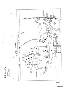
Document - LONG GULLY HISTORY GROUP COLLECTION: THE LONG GULLY GOLF LINKS
Some history of the Long Gully Golf Links, a 9 Hole Course, by John Harvey. First page has a map of the area showing where the holes are and different features. There is a description of the tees and the route taken around the course.Dates when the Eaglehawk, Neangar park, Kangaroo Flat Golf Clubs and the Long Gully Playground were opened.bendigo, history, long gully history group, the long gully history group - the long gully golf links, a crossley, john harvey, long gully rec, dai gum san reservation, quarry hill golf club, bendigo golf club, marong gulf club, miss colgan, sacred heart cathedral choir, mechanics institute, rose of australia hotel, north hercules and energetic mine site, les thomas, tom austen, pearl south mullock heap, doc catford, clubs wearne, pearl mining co's diggings, pearl south, pearl east, bill and faye osterfield, ellen lee osterfield, eaglehawk gold club, neangar park golf club, f m fitzpatrick, kangaroo flat golf club, long gully playground, pearl sands, ennor brothers, birchmore brothers, shirley harvey, belvoir park, harold ennor, george ennor -
 Bendigo Historical Society Inc.
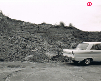
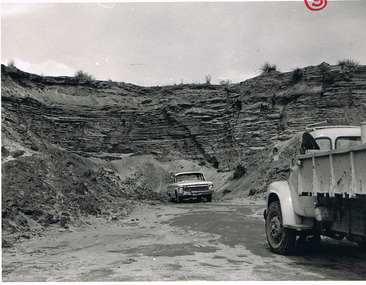
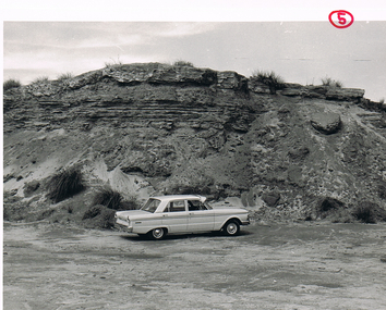
Photograph - MCCOLL, RANKIN AND STANISTREET COLLECTION: SANDY AND MULLOCK HEAP
Black and white photo of car in front of sand heap. Possibly New Monument Gold Mine battery sands.photograph, landscape, mullock and sandy heap -
 Bendigo Historical Society Inc.
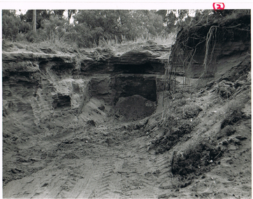
Photograph - MCCOLL, RANKIN AND STANISTREET COLLECTION: VIEW OF EXCAVATION
Black and white photo of a view of excavation into sandy heap below ground level. Possibly battery sands of Monument Hill Gold Mine, Bendigo.photograph, landscape, mullock and sandy heap. -
 Bendigo Historical Society Inc.
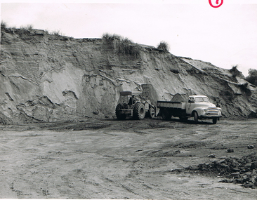
Photograph - MCCOLL, RANKIN AND STANISTREET COLLECTION: PHOTOGRAPH
Black and white photo.Front end loader and tip truck being filled. Possibly New Monument Gold Mine battery sands.photograph, landscape, sandy mullock heap -
 Bendigo Historical Society Inc.
Photograph - MCCOLL, RANKIN AND STANISTREET COLLECTION: PHOTOGRAPH
Photograph.Black and white photo. Car and truck below sand heap. Possibly New Monument Gold Mine battery sands.photograph, landscape, old mullock heap -
Friends of Ballarat Botanical Gardens History Group
Work on paper - Victoria Park Precinct, City of Ballarat, Victorian Heritage Database place details -19/9/2017, 19/9/2017
Victoria Park is associated with gold mining in the 1860's, military manoevres in the late 19th century; as an army base during World War 2 and a recreation area.Victoria Park is a "landmark cultural landscape" in the city of Ballarat. This parkland established 1890-1910, was modelled on English country estates and London Parks. It demonstrates the civic pride of Ballarat citizens and is an important parkland for the local community. There is a collection of exotic and early planted native trees and areas of native grasslands.6 pages of print. p.1. is a front page with a map and Victoria Park marked in purple with a bibliography on p.4 and footnotes on p.6.None.john garner, victoria park, friends of ballarat botanical gardens, heritage overlay, gold mining, parkland, late nineteenth century, native grasslands, exotic and native trees, royal park, mullock heap, mount holled-smith, arbor day, messrs clegg&nicholls, william guilfoyle, w.o.allen, significant tree register, john garner collection, gardens, ballarat -
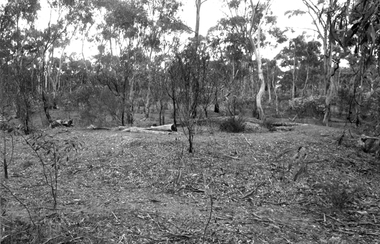 Tarnagulla History Archive
Photograph: Bushland on mullock heaps in Tarnagulla
David Gordon Collection. -
 Bendigo Historical Society Inc.
Photograph - MCCOLL, RANKIN AND STANISTREET COLLECTION: MULLOCK HEAPS
Black and white photo of car in front of a sand dump. Possibly New Monument Gold Mine battery sands.photograph, landscape, mullock and sandy heap. -
 Bendigo Historical Society Inc.
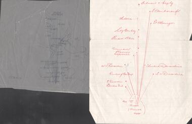
Map - SNOB'S HILL - PLAN OF SNOB'S HILL AREA
Plan drawn on tracing film of sand heap, dams, trig point and mines. Some un-named streets are also drawn in. Piece of notepaper has mines drawn in on a larger scale. Notes prepared by Albert Richardson.map, bendigo, goldfields, snob's hill, plan of snob's hill area, new st mungo mullock heap, duchess trib, s devonshire, duchess of edinburough, w u devonshire, hopewell, phoenix, unicorn, princess alice, lady barkly, sadowa, e u devonshire, united devonshire, l?, ellenborough, belmont & saxby, snob's hill -
 Tarnagulla History Archive
Photograph of Yorkshire Mine Mullock Heap Being Excavated. 1964
-
 Bendigo Historical Society Inc.
Document - VICTORIA HILL - BENDIGO BRANCH HISTORICAL SOCIETY - MINE TOUR
Typed notes for a tour of the area. Areas mentioned are: Hospital Hill, The Central Deborah Mine, New Chum Railway Mine, The Rocks, New Chum Hill, Victoria Hill, Central Nell Gwynne, Rae's Open Cut, Housing Commission Homes and Latham and Watson's. Description of machinery at the Central Deborah Mine, yields, dividends, depth of shafts and directions to get ot the various places is included.document, gold, victoria hill, bendigo branch historical society mine tour, all saints church, joseph la trobe, bendigo's first hospital, sacred heart cathedral, the central deborah mine, city council, londonderry west shaft, new red, white and blue consolidated (big blue), a roberts & sons, big deborah, the new golden fleece, new chum goldfields, central wattle gully mine chewton, virginia consols, black's quarries coldstream, thompson's engineering and pipe co ltd castlemaine, new chum railway mine, golden square methodist church, the rocks, e j dunn, gold monument, shamrock mine, mt alvernia hospital, j b lazarus, john brown knitwear factory, gold fmines hotel, david sterry, new chum hill, fortuna villa, geo lansell, theodore ballerstedt, a h q survey regiment headquarters, old chum mine, central nell gwynne, rae's open cut, theodore ballerstedt, new chum syncline, little 180 mine, victoria quartz, wittcheibe's 'jeweller's shop', adventure, advance, cinderella, j n macartney, bendigo goldfields registry 1870, wm rae, johnson's devonshire mine, snobs hill mine, ellenborough mullock heap, belmont mullock heap, sadowa, st mungo, united devonshire, mechanic's institute, log lock-up, court house, j b watson, housing commission homes, hustlers hill, latham and watsons', the great extended hustlers, a richardson