Showing 585 items
matching old maps
-
 Federation University Historical Collection
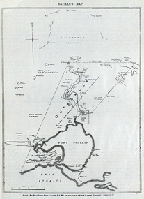
Image, Batman's Map of Port Phillip
Scanned from "The Old Pioneers' Memorial History of Melbourne From the Discovery of Port Phillip to the World War". It is a facsimile map from the House of Commons Reports of Committee.John Batman's map of Port Phillip showing Dutigalla (Batman's Tract), a township reserve, open plains, public common reserve, fresh water"A tract of country [called?] by the native chief of Southern Ausralia to be John Batman 6th June 1935."port phillip bay, john batman, melbourne, iramoo, r. sarsh, river sarsh, river batman, yarra river -
 Federation University Historical Collection
Booklet, Buninyong Heritage Walks and other Interesting Cycle Rides and Scenic Drives, 2008
Blue soft covered book, with maps, plans and photographs relating to Buninyong, Victoria. buninyong, de soza park, buninyong tannery, buninyong railway station, eagle hotel, old buninyong library, hastie's hill, buninyong town hall, hastie's spring, crown hotel, buninyong post office, bowen tree, aborigines, buninyong primary school, buninyong cemetery, gold monument, mount buninyong, lal lal falls -
 Federation University Historical Collection
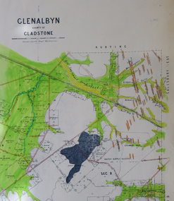
Map, Glenalbyn, County of Gladstone
Copy of a geological map of Glenalbyn. Some areas have been colours green. Creeks have been coloured blue, roads and reefs have been coloured orange.glenalbyn, county of gladstone, tarnagulla, inglewood, kingower, kurting, old inglewood deep lead, salisbury west -
 Ringwood and District Historical Society
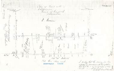
Document - Copy of Lands Department Field Notes - Parish of Ringwood, Victoria, Field Notes 88-9/276 - Part of O.P. R72C surveyed 12.10.1888
Foolscap size photocopy of survey map with handwritten notations. References include - Commencing at bank of creek, Bearing over fence read 134"12', post and rail fence, old round post, Quigley, WB house iron roof, paling & shingle roof, garden, Forshaw formerly Hoare, D Brown, stable & shed, slats & palings, orchard, Occupied by Forshaw, 4 rooms WB Cottage iron roof, Sherbin, Old three chain road, Maroondah Highway, Molloy's corner, I certify that this survey has been effected in accordance with the regulations and that this is a correct copy of my results (signed) - Reed, Assistant Surveyor, 12.10.88. -
 Ringwood and District Historical Society
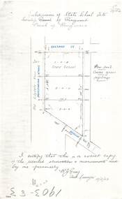
Document - Copy of Lands Department Field Notes - Subdivision of State School Site, Township of Ringwood, Victoria, Field Notes 1903/83 - Part of O.P. R72C Surveyed 13/2/1903
Foolscap size photocopy of survey map with handwritten notations. References include Everard Street, Old Lilydale Road (Maroondah Highway), Dublin Road, poor soil, coarse grass, saplings, I certify that this is a correct copy of the recorded observations & measurements made by me personally (signed) R.J. Gray Autorised Surveyor 13/2/03. -
 Ringwood and District Historical Society
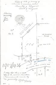
Document - Copy of Lands Department Field Notes - Survey of Extension to Recreation Reserve, Township of Ringwood, Victoria, Field Notes 1907/436 - Part of O.P. R72D Surveyed 6.8.1907
Foolscap size photocopy of survey map with handwritten notations. References include New Lilydale Road 3 chains wide (Mount Dandenong Road), Silurian, undulating, poor grass, Corner cut off to allow for road in future subdivision, Old recreation reserve, (circled area) oval now in use, A. Gisler, I certify that this is a correct copy of the recorded observations & measurements made by me personally (signed) R.J. Gray 6/8/07. -
 Ringwood and District Historical Society
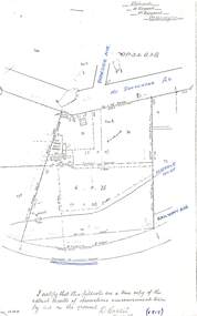
Document - Copy of Lands Department Field Notes - Parish of Ringwood, Victoria, Field Notes - OP34838 - surveyed in 1919 by D. Barker
5615b Foolscap size photocopy of survey map with handwritten notations. References include Braeside Avenue, Mount Dandenong Road, Rosedale Court, Railway Avenue, cyclone fence, Sec A, WB house, old tennis court netted, stable, old shed, tank stand, orchard, Township Boundary, netting fence, Railway fence, Ringwood to Lilydale Railway, I certify that these fieldnotes are a true copy of the actual results of observations & measurements taken by me on the ground (signed) D. Barker (1919). -
 Ringwood and District Historical Society
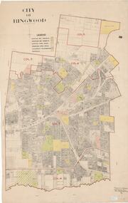
Map, City of Ringwood - Rateable Properties Layout - c.1966. Overlay showing Reserves, Open Space, Playgrounds, and Schools
A0-size (approx) map of named streets, lot-numbered properties and locality features within City of Ringwood boundary. Colour-coded legend identifying Existing Rec Reserves, Proposed Rec Reserves, Existing Open Space, Children's Playgrounds, and Schools.Scale: 8 chains to 1 inch. Map picked up in Engineer's office at old town hall prior to demolition 1971. -
 Ringwood and District Historical Society
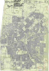
Map, Old Creeks of Ringwood
... -size (approx) City Engineer's map with hand-drawn overlay ...A0-size (approx) City Engineer's map with hand-drawn overlay highlighting natural water-courses in the Ringwood area, as identified by Rob Atkins, former RDHS President. Other pencilled markings include Perry's Hut, Jull's Store, Crawley's Hut.Scale: 8 chains to 1 inch. -
 City of Moorabbin Historical Society (Operating the Box Cottage Museum)
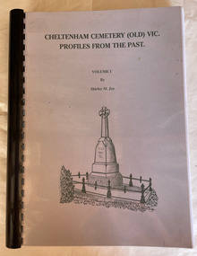
Book, Shirley M. Joy, Cheltenham Cemetery (Old) Vic. : profiles from the past, 1998
... ., maps ; Cheltenham Cemetery (Old) Vic. : profiles from the past ...Profiles of some of the people buried in the Cheltenham Pioneer Cemetery in Charman Road, Cheltenhamv. <1> : ill., maps ;non-fictionProfiles of some of the people buried in the Cheltenham Pioneer Cemetery in Charman Road, Cheltenhamcemetery, cheltenham, cheltenham cemetery -
 Bendigo Historical Society Inc.
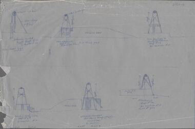
Map - SNOB'S HILL - PLAN OF SNOB'S HILL MINES
a. . Handdrawn copy of Snob's Hill Mines by Caleb Thomas (Long Section) 1885. Top drawing show mines and the distance between them. Lower drawing shows leases at a scale of 8 chains to 1 inch. Dams and sand heaps are included. The second page shows x-sections of the poppet legs and their heights. Shaft numbers are included. Two of the pulley diameters are also shown. b. Document headed Caleb Thomas cross sections 10.10.1884. South Catherine, engine east of shaft legs 44 ft high Ellenborough engine east of shaft, legs 40 feet Belmont and Saxby, engine and wheel west of shaft, legs 27 feet York and Durham, engine and wheel west of shaft legs 27 feet Snobs Hill , Old Williams, engine east of shaft legs 53 feet, L. Brace 21ft. 1884 Acadia Catherine engine west. Legs 44 feet, L.brace 11 ft.map, bendigo, goldfields, snob's hill, plan of snob's hill mines, caleb thomas, c reef united, catherine reef shaft, william's main, acadia, william's old main, gt northern, york & durham, snob's hill, belmont & saxby, ellenborough, st mungo, golden pyke, united c'holders, compy, snowdon & co, sth catherine coy, princess alice, saunders, williams & coy, acadia co, wearon & co, snob's hill, nelson trib, kneebone tribute, la belle co, york & durham, north st mungo, saxby & devonshire trib, n? trib, belmont co, durham c'land, kitti trib, sadowa trib, ran?eu co, nth devonshire co, lady barkly, devonshire reef trib, central devonshire co, j c macartney, catherine united -
 Bendigo Historical Society Inc.
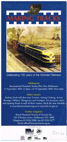
Document - BADHAM COLLECTION: VICTORIAN RAILWAYS- MAKING TRACKS BOOKLETS X 12
... -out map and collage of old railway photos (without notations... brochures x 12. Glossy fold-out map and collage of old railway ...Victorian Railways advertising brochures x 12. Glossy fold-out map and collage of old railway photos (without notations). Articles include 'growing Victoria and various aspects of Railway life, celebrating 150 years of the Victorian Railways C 2004.books, magazines, v/r advertising -
 Bendigo Historical Society Inc.
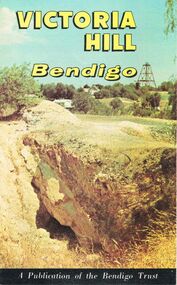
Document - JOAN O'SHEA COLLECTION: VICTORIA HILL GOLDMINING AREA BOOKLET, March 1972
Joan O'Shea Collection. Victoria Hill Bendigo Gold Mining on the Richest Quartz Reef in Bendigo, from 1854 to 1916. Colour and Black and White Booklet 16 Pages. Includes Maps of the Victoria Hill Area, photographs of the remains of a twenty head crushing battery, burnt ground from quartz roasting, The Victoria Quartz Mine Photograph from Australian Mining Standard June 1899, The compressor beds and concrete foundations for the poppet legs all that remain today of the Victoria Quartz Mine deepest mine on Bendigo Goldfield 4613 feet or 1406.04 metres. Also included photograph of the view of Victoria Hill from The New Chum Hill in the 1870s. The Location of the 3 mines Ballerstedt's open cut, North Old Chum and Lansell's 180 are marked. A depiction of Rae's Open Cut gives an understanding of the primitive nature of early workings on the Goldfields. The Booklet also provides a brief history of Victoria Hill itself.Bendigo Trust Publication March 1972. Printed in Bendigo Cambridge Press.bendigo, mining, victoria hill -
Bendigo Historical Society Inc.
Map - CAMPBELL COLLECTION: BENDIGO AND DISTRICT MAPS
Map. Bendigo Whipstick Forest Park, 1:75,000, reserved forest and crown land, highway main road access forest tracks. New Moon Mine, Elliot Dam, Nuggety Dam, Rogers Tree, Old Tom Mine, Blow Holes, Skylark Dam, Monument Rock, Hartland Eucalyptus Still and Dam, Hartland Eucalyptus Farm, Millwood Dam, Sandner Eucalyptus Still Site, Various unmarked dams. (number 391 in map cupboard 1)map, bendigo, country lands -
 Bendigo Historical Society Inc.
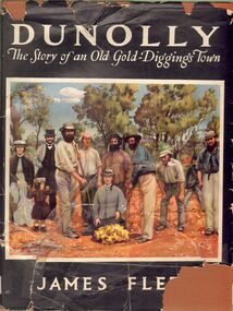
Book - ALEC H CHISHOLM COLLECTION: ''DUNOLLY, THE STORY OF AN OLD GOLD-DIGGINGS TOWN''
Book. ALEC H CHISHOLM COLLECTION. 160 page hardcover 'coffee table' book on the history of the gold rushes at Dunolly and surrounding district by James Flett. Includes 7 maps and 41 illustrations. Published in 1956 by the Poppet Head Press and printed by George H Barrow & Co., Melbourne. Catalogue sticker ''2256 FLE'' on spine. Coloured copy of the photo of the discovery of the 'Welcome Stranger' nugget at Moliagul in 1869 opposite title page.James Flettbooks, collections, history, alec h chisholm collection, james flett, dunolly, gold rush -
 Bendigo Historical Society Inc.
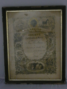
Document - BENDIGO AGRICULTURAL & HORTICULTURAL SOCIETY CERTIFICATE OF MERIT, 1890
Bendigo Agricultural & Horticultural Society Certificate of Merit. Awarded to Miss. H. Maru for Third Prize for Crochet work. 15th & 16th October 1890. Signed by President and Secretary. Photos of animals on front. DR 282 on back. On small accompanying card - From Glasier & Watts (late D.G. Coope) established 1871 Carvers & Gliders. Picture frame manufacturers etc. Old frames repaired and re-gilt. Map plans mounted & varnished plaques plush & ornamental work. Art Gallery. Bath Buildings. Mitchell street. Bendigo.document, certificate, personal -
 Bendigo Historical Society Inc.
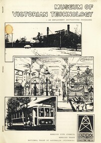
Book - MUSEUM OF VICTORIAN TECHNOLOGY - AN EMPLOYMENT INITIATIVES PROGRAMME, c1983
Museum of Victorian Technology - An Employment Initiatives Programme. Project outline and detail for development of a Museum of Victorian Technology at the Old Gasworks Bendigo. Black and white Illustrations & maps.Bendigo City Council, Bendigo Trust and National Trust of Australia (Victoria)bendigo, history, victorian technology, cast iron museum gas works tourism bendigo -
Bendigo Historical Society Inc.
Book - BENDIGO THE GOLDEN AGE RETRACED, 1973
Bendigo the golden age retraced Front cover is a map of the area using white lines to point out points of interest in Bendigo. These places are then described in brief detail throught the book. There are also illustrations of each place of interest. Part A has a signature inside the front cover dated 1973. b, has a photo of 'Sun Loong' in front of the Shamrock Hotel, at easter time. This is in a plastic folder which is then inside a folded card, with adrawing of the old Town Hall on the front. C, has a library sticker on the lower spine, numbered 0035 nei. With Index. 64 pages.Jan Neilbendigo, buildings, effects of gold in bendigo., . -
Bendigo Historical Society Inc.
Document - Bendigo Tramways Brochure, abt 1950s
In 1890 Bendigo's first tramway battery-electric carriages operated between Sanhurst and Eaglehawk. In 1892 Battery-electrics were replaced by steam tram cars on the Bendigo Railway Station track to Eaglehawk. In 1903 Electric traction overhead was inaugurated extending to Quarry Hill, Golden Square and Lake Weeroona. In 1913 Open cross-seat cars added for the service Quarry Hill to Eaglehawk. In 1945 Traction bogie cars replaced older cars. In 1947 Birney safety cars (dead man controllers) replaced older carsBrochure, a "Welcome to Bendigo, and "Evolution of Bendigo Tramways." 8668.1 Brochure is titled "Welcome to Bendigo," on the front a photo of Charing Cross and Trams, also the Bendigo City Coat of Arms. Inside two pages and descriptions of six tram showing the "Evolution of Bendigo tramways." On the rear is a map of the tramways and places of interest to visit. The brochure was "Printed for the preservation committee in co-operation with the Royal Historical Society of Victoria (Bendigo and District Branch) All donations for a preservation fund."history, bendigo tramways, evolution of bendigo tramways -
 Bendigo Historical Society Inc.
Map - BENDIGO HISTORICAL SOCIETY COLLECTION: EAGLEHAWK MINE MAP
Base map Australian map grid of Eaglehawk area. Map has letter attached from the Department of Conservation, Forests and Lands, 22 March, 1990, addressed to Felicity Kingerlie, BHS, requesting information regarding the historic mining sites marked on the map. Sites marked are: A. Golden Age Mine, engine mountings present B. Johnson's No. 2 Mine, engine mountings, old boiler foundations C. Johnson's No. 1 Mine, mullock retaining wall made from sandstone, engine mountings, remains of old building demolished? D. Toma's Eucalyptus Factory, old boiler still there, boiler shed, chimney (remnants of) outlet drain, distilling vats, dam, remnant of winch. E. New Argus Mine,mullock heap F. New Moon Mines Dams (1) stone walls G. North Lightning Hill Mine, engine mountings, quartz retainer wall, Pascoe and Simmons open cuts and other open cuts here too H. New Prince of Wales Mine and Poppet Head I. Quarry site for stone, excavation (for miners cottages in Clarke Street) J. Lancashire open cut mine K. Virginia Hill (cynaide vats etc) L. South Prince of Wales mine, now capped and fenced M (possibly ) Catherine United Mine, engine mountings, battery mountings?bendigo, mining, eaglehawk mines -
Bendigo Historical Society Inc.
Book - TOURING SACRED MINE SIGHTS OF BENDIGO, 1994
16 page booklet 'Touring Sacred Mine Sights of Bendigo' Produced by Bendigo Mining and the Victorian Chamber of Mines.1994. Researched and written by David Horsfall and printed by Bendigo Modern Press. Details and suggested walking and driving tours of old mine sites. Includes 3 maps.David G Horsfall -
Bendigo Historical Society Inc.
Map - MAP WHITE HILL TO HUNTLY
Map of Bendigo creek and adjacent leads - White Hills to Huntly replotted from old 4 chain to 1 inch survey of 1860 by G. W. Hart - Surveyor. Base of roads and streets taken from D.L.S. 1 . 10000 base maps. Legend: battery site, puddling mill site, dam bank site, cutting altering course of creek, lead boundaries.bendigo, mining -
 Bendigo Historical Society Inc.
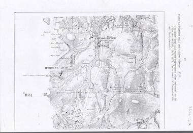
Document - DIAMOND HILL AREA MAP
Map copy, 2 pages, from 'Old Mines Department Plan, Dept of Conservation and Environment File No W91006, 16.6.1972' Map shows Golden Gully area with 'Town and Country Hotel' on north side and further south, with shafts and mine names marked.bendigo, mining, diamond hill -
 Bendigo Historical Society Inc.
Document - OLD PEOPLES WELFARE SOCIETY COLLECTION: BANK STATEMENTS
COLLECTION OF RECORDS OF BENDIGO AND DISTRICT OLD PEOPLES WELFARE SOCIETY / Manilla folder / writing note on front B.O.P.W.S.Salvation Army , St Lukes , St Vincents De Paul , Bendigo Uniting Church Outreach , Notice to Members / inside includes news clippings , Bank statements , passbook , letters / history of the society , mention of founder Ken Hesse , Annual Return , Rules , map of Golden Oaks Villagedocument, ken hesse -
Bendigo Historical Society Inc.
Map - NEW CHUM & VICTORIA LINES OF REEF - PLAN OF NEW CHUM & VICTORIA LINES OF REEF
Two pages of a Plan of New Chum & Victoria Lines of Reef, compiled by G. W. Hart. Taken from J. N. Macartney's G'Fields Registry for 1871. Plan shows leases from High Street to California Gully. Location of the Manchester Arms, British & American Hotel and the Quartz Miners Arms are shown. Townships of Long Gully and Ironbark are shown.map, goldfields, new chum & victoria lines of reef, plan of new chum & victoria lines of reef, victoria catharine g m coy, thornton & co, extd victoria reef g m co, ural tribute compy, nil desperandum compy, koch, north victoria g m co, danger hill coy, north endeavour coy, wheadon & co, pilot co, north energetic co, energetic compy, endeavour company, hercules co, victoria gold mines compy, iron duke g m co, golden fleece united, ballerstedt, alfred co, confidence co, prince alfred co, canterbury co, advance co, wells, humboldt co, adventure co, try me well, sterry & co, gibbs & ballerstedt, handy andy, wells?, south adventure co, w rae, victoria reef quartz m co, myra co, jackson, wybrants, burrows & sterry, new chum & victoria tribute, old chum co, ballerstedt, lazarus, watson, koch & hildebrand, lansell & hunt, dennis, abe lincoln co, bonati & co, ellesmere co, moore late menzies, british co, british tribute co, garibaldi, c c co, new chum trib, dobson & co, young chum co, little chum co, old chum co, new chum trib, little chum trib, g w hart, j n macartney's g'fields registry for 1871, manchester arms, british & american, quartz miners arms -
Bendigo Historical Society Inc.
Map - HUSTLER'S & CHRISTMAS LINES OF REEFS - PLAN OF LINES OF SECTION OF REEFS
Underground Survey of Mines Bendigo. Plan of Cross Section Lines Shewing Connections with Trigonometrical Stations and Base Lines. 13/3/99 Signed ? Stirling. Places and mines mentioned Speciman Hill, Tambour Major, Lansell's 180, Victory and Pandora, Great Extended Hustler's, Windmill Hill on Victoria Reef. Next part of map is a Plan of Lines of Section between the Hustler's and Christmas Lines of Reefs. 8/3/99. Signed ?. Transverse Section. Shows Tambour Major Co., near the Christmas Line of Reef, Crosscuts and their depth, geological features and stone encountered. Then shows Thistle Line, Charshalton Line, Napoleon Line, Nell Gwynne Line, New Chum Line, Lansell's No 180 with levels, depths and geological features. Drawing is continued in three parts to fit on paper. Lansell's East Shaft with levels and depths, geological features and stone encountered. Sheepshead Line, Old Shaft, Garden Gully Line, Victory and Pabndora Co with crosscuts, depths, geological features and stone encountered. Paddy's Gully Line, Derby Line, Millers Line, Hustler's Line, Great Extended Hustler's Co with levels, depths, geological features and stone encountered. A note beside a Saddle Reef: 360,000 pounds paid in dividends from this reef. Average ounces per ton gold noted where found. Reference Table for stone and geological features. Datum Line 700 feet above Sea Level Unscannedmining, parish map, hustler's & christmas lines of reefs, plan of lines of section of reefs, ? stirling, specimen hill, tambour major, lansell's 180, victory & pandora, great extended hustler's, windmill hill, victoria reef, tambour major co, christmas line, hustler's line, thistle line, carshalton line, napoleon line, nell gwynne line, new chum line, lansell's no 180, lansell's east shaft, sheepshead line, old shaft, garden gully line, paddy's gully line, derby line, miller's line, hustler's line, great extended hustler's co -
Bendigo Historical Society Inc.
Map - GREAT EXTENDED HUSTLER'S MINE - LONGITUDINAL SECTION OF THE GREAT EXTENDED HUSTLER'S MINE
Longitudinal Section of the Great Extended Hustler's Mine on the Hustler's Line of Reefs. Bulletin No 33, Plate No XIII. Map shows the Hustler's Tribute, 2 Old Shafts, Great Extended Hustler's Shaft, Latham & Watson's Shaft and Ironbark Gully. Datum Line 750 feet above Sea Level. Poppet Legs on the surface and Sill of Shaft 788.99 feet above Sea Level. Levels and their depths are shown and some geographical features. Some amounts of gold mined mentioned. Geological Survey of Victoria emblem and signed by H A Whitelaw, Underground Survey Office Bendigo, September 1913. Note - Plates 4, 8, 13,20, 26 & 31 form a Longitudinal Section from Fortuna Hustlers to Hustler's Consols Mine. This item has not been scanned or photographed.mining, parish map, great extended hustler's mine, longitudinal section of the great extended hustler's mine, geological survey of victoria, underground survey office bendigo, h a whitelaw, hustler's tribute, old shaft, great extended hustler's shaft, latham & watson's shaft, ironbark gully -
Bendigo Historical Society Inc.
Map - GREAT EXTENDED HUSTLER'S MINE - TRANSVERSE SECTION OF THE GREAT EXTENDED HUSTLER'S MINE
Transverse Section of the Great Extended Hustler's Mine on the Hustler's Line of Reef. Bulletin No 33, Plate No XII. Shows Poppet legs at the surface and Sill of Shaft at 788.99 feet above Sea Level, Cross Cuts and their depths, stone and geographical features encountered and their references and a number of enlarged drawing of sections of the cross cuts, Geological Survey of Victoria emblem and signed by H A Whitelaw, Underground Survey Office Bendigo, September 1913. The depths of crosscuts to No 21 were taken from plans of surveys by Mr Walker and Mr Craven, noted under Reference. Another note: This Saddle Reef is sketched from Mr Walker's plan. Dividends amounting to 360,000 pounds were obtained from it. This item has not been scanned or photographed.mining, parish map, great extended hustler's mine, transverse section of the great extended hustler's mine, old shaft, mr walker, mr craven, geological survey of victoria, underground survey office bendigo, h a whitelaw -
Bendigo Historical Society Inc.
Map - HUSTLERS LINE OF REEFS - LONGITUDINAL SECTION THROUGH THE SADDLE REEFS
Drawing with Longitudinal Section through the Saddle Reefs along portion of Hustler's Line of Reefs, Bendigo. Map shows the depth of the mines, reef numbers and Datum 700 ft above sea level. North and South is also noted on the map. Map signed by H. S, Whitelaw, Underground Survey Office, Bendigo, September 1913. Bulletin No 33, Plate No XXXIV. Bendigo Creek, Ironbark Creek and Long Gully are also noted. Mines are: Fortuna Hustlers, Hustler's Royal Reserve No 2 Main Shaft, Hustler's Royal Reserve No 2 Park Shaft, Royal Hustler's, Imperial Hustler's, Extended Hustler's Freehold, Great Extended Hustler's Tribute (Pups), Old Shaft, Great Extended Hustler's Reef No 2, Great Extended Hustler's Main Shaft, Old Shaft, Hustler's Reef, Hustler's Reef No 1, Comet, K. K., United Hustler's & Redan, Old Shaft and Hustler's Consols. Has Geological Survey of Victoria Crest and underneath is: H. Herman, Director, W. Dickson, Secretary for Mines, The Hon. J Drysdale Brown M L C. Minister of Mines.Geological Survey of Victoria Crestmining, parish map, hustler's reef maps, hustlers line of reefs, bendigo creek, ironbark creek and long gully are also noted. mines are: fortuna hustlers, hustler's royal reserve no 2 main shaft, hustler's royal reserve no 2 park shaft, royal hustler's, imperial hustler's, extended hustler's freehold, great extended hustler's tribute (pups), old shaft, great extended hustler's reef no 2, great extended hustler's main shaft, old shaft, hustler's reef, hustler's reef no 1, comet, k. k., united hustler's & redan, old shaft and hustler's consols.h s whitelaw, underground survey office bendigo september 1913, bulletin no 33 plateno xxxiv, mi -
 Bendigo Historical Society Inc.
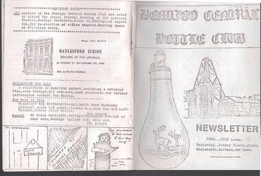
Document - JAMES LERK COLLECTION: BENDIGO CENTRAL BOTTLE CLUB NEWSLETTER
Bendigo Central Bottle Club Newsletter - James Lerk Collection (June /July 1976). Article on ''Old Inglewood'' (by Ken Arnold) - information on 1858 - 1860s with sketch map of gullies in area; Reference to bottle of T R Jones, Chemist of Bendigo (Pall Mall, near Allans Walk); list of some other bottle manufacturers in Bendigo.