Showing 147 items
matching on this day in the north east
-
 Wodonga & District Historical Society Inc
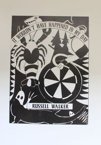
book - It Wouldn't Have Happened in My Day, Russell Walker, 1997
An anthology of poetry dedicated to " those former primary students of the North East / Upper Murray Region of Victoria whose ideas and imaginations are indirectly responsible for many of the poems printed in this volume."An anthology of poetry. It consists of 73 pages including black and white Illustrations stapled down the centre.fictionAn anthology of poetry dedicated to " those former primary students of the North East / Upper Murray Region of Victoria whose ideas and imaginations are indirectly responsible for many of the poems printed in this volume."north east victoria, upper murray region, poetry -
 Wodonga & District Historical Society Inc
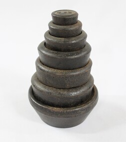
Functional object - Imperial Postal Weights used in the Post Office in Wodonga
The set of seven imperial weights were used in the Post Office in Wodonga. The first Post Office in Wodonga opened on the 6th June 1856, and a second Post Office was built in 1874 on the corner of Sydney Road which became High St. and South St. In 1878 there were three staff at the Wodonga Post Office, including the Postmaster/Telegraph Manager and two Office-Keepers/Messengers. The mail service in 1878 included delivery four times a day from the Railway Station to the Post Office in Wodonga, and to and from the Wodonga Post Office to Albury twice a day.The set of seven imperial weights has local and state significance as it was used in the Wodonga Post Office in North East Victoria before decimal currency was introduced in Australia in 1966. The weights also have national significance as examples of the equipment used in post offices in Australia pre 1966.Set of seven cast iron and lead weights with imperial measurements '4 oz, 8oz, 1 lb, 2 lb, 3 lb, 4 lb, and 7 lb' The exterior circular black painted cast iron encases the heavy inner grey lead component, which is visible from the underside. "4 oz.", "8 / oz.", 1 lb.", "1 lb.", "2 lb.", "3 lb.", 4 lb.", MERCURY / 7 LB." on the top of the weights in raised numbers and letters.wodonga post office, post office, victoria post offices, wodonga, north eastern victoria post offices, victorian mail service -
 Wodonga & District Historical Society Inc
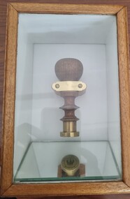
Functional object - Seal - Police Office, Belvoir
This seal was used for official police and court documents by the Belvoir Police Office.The initial land survey for the city now known as Wodonga was first undertaken in 1852 by Thomas Wedge - Assistant Surveyor. The new township was called "Belvoir" and was proclaimed by that name in 1852 and again in 1861. The first sale of land in Belvoir was held at Wangaratta on April 28, 1854, when all the allotments surveyed by Thomas Wedge (excepting those set apart for reserves, government and public areas) were offered at auction. Following representations by the Postmaster General on June 23, 1869, the Governor in Council, on July 12, 1869, approved of its Aboriginal name "Wodonga" being restored. The seal was found at the Yackandandah Courthouse by the Circuit Judge, the late Mr. Jim Humphrey. As the Wodonga Historical Society was in recess at that time, the seal was held in trust by the North-East Historical Society in Wangaratta. It was donated to the Wodonga Historical Society in 1987.This item was the official seal of the Belvoir Police office from the beginning of the European settlement of the modern day city of Wodonga, then know as Belvoir. It is one of the earliest relics of that period of history, until its name was changed in 1869.Wood and metal seal bearing the official emblem of the Police Office Belvoir. It would have been used to apply a wax seal to official documents. The seal is mounted in a timber and glass case so that the imprint of the seal can be seen reflected in a mirror mounted in the base of the box.Around the edges of the seal "POLICE OFFICE / BELVOIR"belvoir police, official seal, history wodonga -
 Department of Energy, Environment and Climate Action
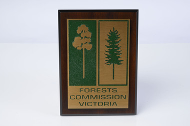
FCV presentation plaque and mould
The wooden mould was originally made in the early 1980s by one of the crew in his spare time in East Gippsland (Bairnsdale maybe). It was passed it on to Ian Long and then Barrie Marsden at Altona. It was not made for any particular purpose other than just a copy of the iconic FCV logo. It sat in the office at Altona for a little while until one day Barry thought it could be used to cast a solid replica. The wooden mould was taken to a foundry in North Melbourne and three bronze replicas were cast and polished. One was used when the Chief Fire Officer, Bary Johnson, was retiring More were cast in brass and the plaques became a standard presentation item for retiring FCV personnel. The wooden mould eventually cracked and can no longer be used. Hand madeWooden mould and presentation plaqueforests commission victoria (fcv), forest signs -
 Wangaratta RSL Sub Branch
Plaque
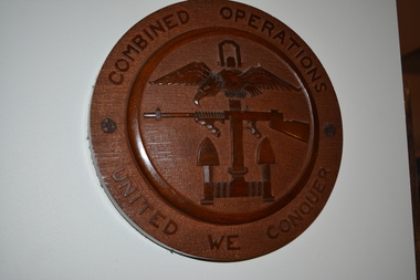
Combined operations plaque - designed and carved by Petty Officer Joiner 3rd Class A W VENABLES on behalf of the Commanding Officer of HMS Northney attached to Combined Operations in the Second World War.Combined Operations made a huge contribution to the successful outcome of the Second World War by undertaking dozens of Commando raids and landings, mostly against the Axis forces, from Norway in the north to Madagascar in the south and from North Africa and the Mediterranean in the west to the Far East, culminating in the D-Day Invasion on the 6th of June 1944.Round solid timber plaque with eagle over sub machine gun over anchor carved in centre.Combined Operations - United We Conquercombined operations, ww2 -
 Wangaratta RSL Sub Branch
Print - Framed print
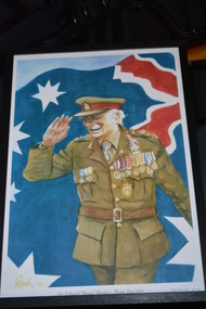
Colonel Sir Ernest Edward "Weary" Dunlop, AC, CMG, OBE (12 July 1907 – 2 July 1993) was an Australian surgeon who was renowned for his leadership while being held prisoner by the Japanese during World War II. Born 12 July 1907 Major Plains, Victoria Died 2 July 1993 (aged 85) Service/branch Australian Army Years of service 1935–1946 Rank Colonel Unit Royal Australian Army Medical Corps 2/2nd Casualty Clearing Station Commands held No.1 Allied General Hospital Battles/wars World War II Battle of Greece North African Campaign Syria-Lebanon campaign South West Pacific New Guinea Campaign South East Asia Campaign Awards Companion of the Order of Australia Knight Bachelor Companion of the Order of St Michael and St George Officer of the Order of the British Empire Knight of the Venerable Order of Saint John Mentioned in Despatches Black timber frame containing coloured caricature of saluting Army Officer with flag in background.Sir Edward "Weary" Dunlop - Anzac Day 1993 Print No 455 of 500colonel sir ernest edward dunlop, "weary" dunlop, surgeon -
 Eltham District Historical Society Inc
Photograph - Digital Photograph, Alan King, Alistair Knox Park, Eltham, 2008
Alistair Knox Park, an oasis of peace and beauty. Covered under National Trust of Australia (Victoria) Landscape Significance and Heritage Overlay, Nillumbik Planning Scheme. Published: Nillumbik Now and Then / Marguerite Marshall 2008; photographs Alan King with Marguerite Marshall.; p173 It is hard to imagine that the Alistair Knox Park, an oasis of peace and beauty beside busy Main Road, Eltham, was once the township’s rubbish dump. It was only in the 1970s that the tip was transformed into this beautiful six hectare space, which later earned it a National Trust Landscape classification. Before its life as a dump, the area was used for small farms. Thanks largely to the foresight and efforts of local environmental builder Alistair Knox, the park was designed sympathetically with the character of the wider Eltham landscape. Then, appropriately, the park was named after Knox, who was an Eltham Shire Councillor from 1971 to 1975 and Shire President in 1975. The park designers were four major forces in the urban bush landscape garden –Knox, landscape designer Gordon Ford, artist Peter Glass and landscaper Ivan Stranger. The National Trust citation for the park, originally called Eltham Town Park, includes the Eltham railway trestle bridge and the Shillinglaw Cottage. The citation states ‘the semi-natural setting of the parkland provides a landscape which is evocative of the history of the area’. Manna Gums (Eucalyptus viminalis) and Candlebarks (Eucalyptus rubida) are significant features. Most of the park’s construction was directed by Bob Grant, Superintendent of the Parks and Gardens Department for the Eltham Shire Council. First plantings occurred in Arbour Week in 1973, then the lake and botanic area were completed in 1975, with Federal Government funding, and the toilet block in 1978. Bounded by the Eltham railway line, Panther Place, Main Road, Bridge and Susan Streets, the park is in a valley about a kilometre wide overlooked by steep hills at the east and west. The Diamond Creek flows through it and the picturesque historic timber trestle railway bridge edges the north. Informal plantings of Australian indigenous and native species in open and undulating grassed settings blend with the natural landscape of the Diamond Creek to the west. The bush-style plants, particularly around the creek, balance with open lawns, paths and a cascade flowing from a small lake to another below. A footbridge over the creek leads to the park’s west. The park includes an adventure playground and barbecue areas. The park stands on part of the land bought from the Crown in 1851 by Josiah Holloway, who subdivided it into allotments and which he called Little Eltham. Most of the land was subdivided into residential lots, but the creek valley, on which the park stands, was subdivided into farm-size lots, used mainly for orchards and grazing. One of the earliest owners was John Hicks Petty, who in 1874 bought a plot from Holloway. Other families who owned properties in that area, included Rees, Clark, Waterfall, Graham, Hill and Morant. In 1901 the railway was built through the area. Jock Read, an Eltham resident since around 1920, remembers several farms in the 1920s and ’30s that occupied the site of today’s park. A poultry farm, which extended from present day Panther Place, was owned by the Gahan family. Next to that farm was another for grazing cattle owned by Jack Carrucan. Beside this was land owned by John Lyon. A doctor lived beside this, and at the north-west corner of Bridge Street and Main Road stood a memorial to the soldiers who died in World War One, which was later moved to the RSL site. Mr Read also remembers other farms and orchards west of the creek In the early 1960s the Eltham Council began buying these farms and in the late 1960s turned the areas east of the Diamond Creek into a garbage tip. When this was filled above the creek’s flood plain, the tip was moved to the west of the creek.This collection of almost 130 photos about places and people within the Shire of Nillumbik, an urban and rural municipality in Melbourne's north, contributes to an understanding of the history of the Shire. Published in 2008 immediately prior to the Black Saturday bushfires of February 7, 2009, it documents sites that were impacted, and in some cases destroyed by the fires. It includes photographs taken especially for the publication, creating a unique time capsule representing the Shire in the early 21st century. It remains the most recent comprehenesive publication devoted to the Shire's history connecting local residents to the past. nillumbik now and then (marshall-king) collection, alistair knox park, eltham -
 Wodonga & District Historical Society Inc
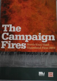
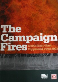
Book - The Campaign Fires - North-East/East Gippsland Fires 2003, Lyndel Hunter, 2003
A description of efforts to fight the bushfires in Gippsland in 2003, including maps and illustrations This volume was published as a tribute to the work of staff and volunteers who put themselves at risk to protect local communities. It shows the impact on those communities in Victoria and the support they gave to those involved in fighting largest bushfires in Victoria for 60 years. The Alpine bushfires started on 8 January 2003, a day of Total Fire Ban. Lightning ignited 87 fires in the North-East and East Gippsland regions. Eight of these fires were unable to be contained; they joined together to form the largest fire in Victoria since the Black Friday fires in 1939. The majority of the area burnt in Victoria was public land, 1.19 million hectares of parks and forests, including 60 per cent of the Alpine National Park and 81 per cent of the Mt Buffalo National Park. Firefighting efforts were made difficult in hard to access, remote forest terrain. Approximately 90,000 hectares of private land was burnt.This publication of 119 pages features text, colour images, maps and detailed information related to the 2003 bushfires in Victoria.non-fictionA description of efforts to fight the bushfires in Gippsland in 2003, including maps and illustrations This volume was published as a tribute to the work of staff and volunteers who put themselves at risk to protect local communities. It shows the impact on those communities in Victoria and the support they gave to those involved in fighting largest bushfires in Victoria for 60 years. The Alpine bushfires started on 8 January 2003, a day of Total Fire Ban. Lightning ignited 87 fires in the North-East and East Gippsland regions. Eight of these fires were unable to be contained; they joined together to form the largest fire in Victoria since the Black Friday fires in 1939. The majority of the area burnt in Victoria was public land, 1.19 million hectares of parks and forests, including 60 per cent of the Alpine National Park and 81 per cent of the Mt Buffalo National Park. Firefighting efforts were made difficult in hard to access, remote forest terrain. Approximately 90,000 hectares of private land was burnt.forest fires -- victoria, bushfires, fires prevention and control -
 Melbourne Tram Museum
Ephemera - Timetable, The Met, Set of 18 Tram Timetables, produced by The Met, 1986 - 1988
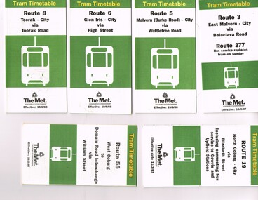
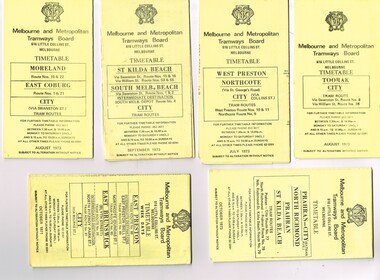
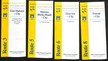
Set of 18 Tram Timetables, produced by The Met for various routes, white cover with two green, multi fold horizontal sheet, giving a route map, description, notes, time points, information contact details and types of tickets (Neighbourhood and Travelcards) and where they could be purchased. .1 - Route 3 - East Malvern - City via Balaclava Road - replaced by bus 377 on Sundays - dated 14/9/1987 .2 - Route 5 - Malvern Burke Road - City via Wattletree Road - 19/6/1988 .3 - Route 6 - Glen Iris - City via High St - 19/6/1988 .4 - Route 8 - Toorak - City via Toorak Road - 19/6/1988 .5 - Route 19 - North Coburg - City via Elizabeth St including connecting bus service to Gowrie and Upfield stations - 11/3/1987 .6 - Route 55 - West Coburg - Domain Interchange via William St - 11/2/1987 .7 - Route 57 - West Maribyrnong - City via North Melbourne - Route 357 bus replaces tram on Sunday - 1/12/1986 .8 - Route 59 - Airport West - City via Essendon -1/12/1986 .9 - Route 64 - East Brighton - City via Hawthorn Road - 14/9/1987 .10 - Route 67 - Carnegie - City via Glenhuntly Road - 14/9/1987 .11 - Route 69 - Kew (Cotham Road) - St Kilda Beach via Glenferrie Road - 19/6/1988 .12- Route 72 - Camberwell - City via Malvern Road - 19/6/1988 .13 - Route 75 - East Burwood - City via Flinders St - 15/2/1988 .14 - Route 78, Route 79, North Richmond - Prahran via Chapel St and North Richmond - St Kilda Beach via Chapel St - 13/7/1987 .15 - Route 82 - Footscray Moonee Ponds via Highpoint City and Route 223 bus replacement for Saturday afternoon and all day Sunday. 3/8/1987 .16 - Route 88 - Bundoora - City via Preston .17 - Route 96 - East Brunswick - St Kilda Beach via Bourke St City - 22/11/1987 .18 - Route 111 - Royal Exhibition Buildings - Port Melbourne via Bourke St City - 20/12/1987. (2nd copy added 1/4/20201( .19 - Route 600 - St Kilda - Middle Brighton via Elwood - 1/12/1986 Full Image of .5 added 9/4/17 following a query about route 19 timetables - see image i6.trams, tramways, timetables, tickets, tram services, route 3, route 5, route 6, route 19, route 55, route 57, route 59, route 64, route 8, route 67, route 69, route 72, route 75, route 78, route 78, route 79, route 82, route 88, route 86, route 111, route 600 -
 Melbourne Tram Museum
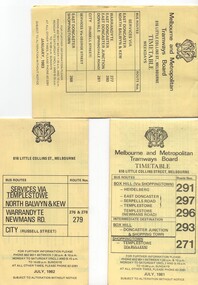
Ephemera - Timetable, Melbourne & Metropolitan Tramways Board (MMTB), Set of 14 MMTB Bus timetables, Jul. 1969
All July 1969 - no route numbers shown. .1 - Box Hill - Heidelberg - Templestowe .2 - East Kew - Box Hill - Doncaster .3 - Deer Park - Sunshine Park - Sunshine - Footscray - City .4 - Fishermen's Bend - City .5 - Williamstown Rd - Footscray Railway Stn - Ballarat Rd .6 - Garden City - City .7 - La Trobe University - Northland - West Heidelberg - City .8 - Box Hill - North Blackburn .9 - Bulleen - North Kew - City .10 - Clifton Hill - Elsternwick .11 - Box Hill - East Doncaster - Mitcham - Ringwood .12 - Deer Park - Sunshine Park - Sunshine - Footscray - City - Saturdays and Sundays - printed on pink paper. 13 - Warrandyte - Donvale Post Office - City 14 - Warrandyte - Park Orchards, Ringwood.Yields information about MMTB Bus services July 1969Set of 14 MMTB Bus timetables, folded sheets, providing timetables for specific routes, day of week giving information on tram times at specific time points, route map, sections and fares and organisation address - 616 Little Collins St. Melbourne.trams, tramways, timetables, tickets, bus services, fares, mmtb -
 Melbourne Tram Museum
Ephemera - Timetable/s, Melbourne & Metropolitan Tramways Board (MMTB), "MMTB Tram Timetables", 1971 and 1973
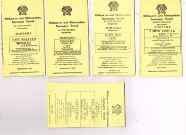
Set of 20 MMTB Tram timetables, folded sheets, generally 10 sections, providing timetables for specific routes, day of week giving information on tram times at specific time points, route map, sections and fares and organisation address - 616 Little Collins St. Melbourne. All printed on yellow paper unless noted otherwise. .1 - Route 8 and 38, Toorak - City - August 1973 .2 - Route 9, 10 and 11, West Preston, Northcote - City - July 1973 .3 - Route - 1, 2, 4, 15, 16, 53, 55 - St Kilda Beach, south Melbourne Beach - City - September 1973 .4 - Route 1, 21, 15, 22 - Moreland, East Coburg - City - August 1973 .5 - Route 77, 78, 79 - Prahran - City, North Richmond, St Kilda Beach - October 1973 .6 - Route 88, 89, 90, 97 - East Preston, East Brunswick - City - October 1971 .7 - ditto - printed on green paper for Saturdays and Sundays. .8 - Route 59 - Essendon - City - June 1961 .9 - Route 8 - Toorak - City - Oct 1961, printed on yellow paper .10 - Routes 48, 40, 41, 37 and 74, 75, 76, 28 - North Balwyn or Burwood to City - March 1972 lists all the short routes by name and printed on yellow paper. .11 - Route 55, 56 and 68 - West Coburg - City or Domain Road - March 1972 - printed on yellow paper. .12 - Routes 48, 24, 40, 41, 29, 74, 75, 76 and 28 - North Balwyn or Burwood to City - March 1976 - printed on yellow paper. .13 - as for .12, Saturdays and Sundays - printed on green paper, ,14. - Route 19, 20 and 18 - Coburg - March 1972 - includes connecting bus to Upfield ,15 - Routes 1, 21, 15 and 22 - Moreland and East Coburg - March 1972 .16 - Routes 64, 65, 62 and 61 - East Brighton - June 1973 .17 - Route 3 - East Malvern - June 1973 ,18 - Route 5, 35 - June 1973 .19 - Route 82 - Footscray - Moonee Ponds - Oct. 1974 - bus Saturday afternoons and Sundays .20 - Route 67, 37 and 66 - Carnegie - June 1973trams, tramways, mmtb, timetables, melbourne, upfield, fares, route 1, route 2, route 3, route 4, route 5, route 8, route 9, route 10, route 11, route 15, route 16, route 18, route 19, route 20, route 21, route 22, route 38, route 35, route 37, route 53, route 55, route 66, route 67, route 77, route 78, route 79, route 88, route 89, route 90, route 96, route 97, route 59, route 48, route 40, route 41, route 37, route 74, route 75, route 76, route 82, route 28, route 55, route 56, route 68, route 29, route 24 -
 Melbourne Tram Museum
Ephemera - Timetable/s, Melbourne & Metropolitan Tramways Board (MMTB), "MMTB Tram Timetables", 1975
Set of 9 MMTB Tram timetables, folded sheets, generally 10 sections, providing timetables for specific routes, day of week giving information on tram times at specific time points, route map, sections and fares and organisation address - 616 Little Collins St. Melbourne. All printed on yellow paper unless noted otherwise. .1 - Route 3 - East Malvern 3 - Bus Route Sundays Only, Feb. 1975 .2 - Route 5, 35 - Malvern - City .3 - Route 6, 7, 36 - Glen Iris - City .4 - Route 19, 18, 20 - North Coburg - City and Sundays only - Fawkner to Gowrie, Upfield - May 1975 .5 - Route 55, 56, 68 - West Coburg - City - Domain Road - May 1975 .6 - Route 57, 54, 60, 58 and 50 - West Maribyrnong - City - Feb. 1975 .7 - Route 64, 65, 62, 61 - East Brighton - City - June 1975 .8 - Route 66, 67 and 37 - Carnegie - City - June 1975 .9 - Route 82 - Footscray - Highpoint West - Moonee Ponds (Bus service Saturday afternoons and Sundays - November 1975. See Reg Item 2886 for a tramway check ticket for use on the Upfield line.trams, tramways, mmtb, timetables, melbourne, fares, upfield, bus replacement, route 3, route 5, route 6, route 7, route 18, route 19, route 20, route 35, route 36, route 37, route 50, route 54, route 55, route 56, route 57, route 58, route 60, route 61, route 62, route 64, route 65, route 66, route 67, route 68, route 82 -
 Melbourne Tram Museum
Ephemera - Timetable/s, Melbourne & Metropolitan Tramways Board (MMTB), "MMTB Bus Timetables", 1983
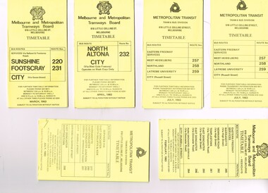
Timetables for specific routes, day of week giving information on tram times at specific time points, route map, sections and fares and organisation address - 616 Little Collins St. Melbourne. All printed on yellow paper unless noted otherwise. .1 - Route 220 and 231 - Sunshine - Footscray - City - March 1983 .2 - North Altona - City via West Gate Freeway - April 1983 .3 - Route 257, 258, 259 - West Heidelberg, Northland, Latrobe University - City - July 1983 .4 - ditto .5 - Route 265, 262, 261, 260, 266, 264 - Warrandyte, Templestowe, Doncaster, Park Orchard - Donvale - City - Feb. 1983 .6 - Route 277, 280, 299, 281 and 268 - Warrandyte, East Doncaster, Donvale, Shoppingtown - July 1983 .7 - Route 287, 286, 302, 303 Box Hill, Mitcham, East Doncaster, Mitcham, Ringwood - June 1980 .8 - ditto - but November 1983 .9 - Route 313, 314, 315, 316 - Warrandyte, Park Orchards, Mitcham - Jan. 1983 .10 - as for .8 11 - Routes 265, 262, 261,260, 266 and 264 - Warrandyte - Eastern Freeway, Templestowe, Park Orcards - Feb. 1983 12 - Routes 277, 280, 281 and 268 - East Doncaster, Donvale, City and Shoppingtown - Jan. 1983 Items .3, .4, .6, .8 and .10 are headed "Metropolitan Transit", rest MMTB.Yields information about MMTB Bus Services 1983Set of 12 MMTB or Metropolitan Transit Bus timetables, folded sheets, generally 10 sections.trams, tramways, mmtb, timetables, melbourne, fares, buses, deer park, sunshine, footscray, latrobe university, northland, heidelberg, box hill, warrandyte, doncaster, donvale, mitcham, ringwood, park orchards -
 Melbourne Tram Museum
Ephemera - Timetable/s, The Met, "The Met Tram Timetable", 1987 and 1988
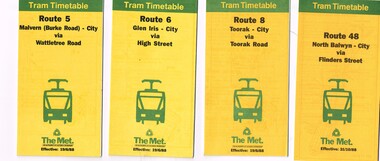
Set of 9 The Met Tram timetables, folded sheets, 8 -10 sections, providing timetables for specific routes, day of week giving information on tram times at specific time points, route map, sections and fares and phone contact numbers. Route 5 - Malvern (Burke Road) - City via Wattletree Road - June 1988 Route 6 - Glen Iris - City via High St - June 1988 Route 8 - Toorak - City - June 1988 Route 48 - North Balwyn - City via Flinders St - Oct. 1988 Route 67 - Carnegie - City - Sept. 1987 Route 86 - Bundoora - City via Preston - Aug. 1988 Route 72 - Camberwell - City via Malvern Road - June 1988 Route 75 - East Burwood - City via Flinders St - Feb. 1988 Route 96 - East Brunswick - St Kilda Beach (Light Rail) - Oct 1988trams, tramways, the met, timetables, melbourne, fares, route 5, route 6, route 8, route 48, route 67, route 86, route 72, route 75, route 96 -
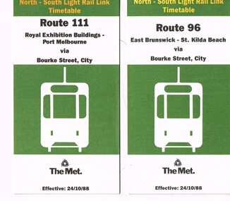 Melbourne Tram Museum
Ephemera - Timetable/s, The Met, "The Met Tram North-South Light Rail Line Timetable", Oct. 1988
Set of 2 The Met Tram timetables, folded sheets, 7 or 10 sections, providing timetables for specific routes, day of week giving information on tram times at specific time points, route map, sections and fares and phone contact numbers. Titled "The Met Tram North-South Light Rail Line Timetable" Issued at the time of the opening of the light rail services along the former St Kilda and Port Melbourne railway lines. .1 - Route 96 - East Brunswick - St Kilda Beach via Bourke St city - 24/10/1988 .2 - Route 111 - Royal Exhibition Buildings - Port Melbourne via Bourke St City - 24/10/1988trams, tramways, the met, timetables, melbourne, fares, light rail, route 96, route 111, conversion, port melbourne, st kilda, east brunswick -
 Melbourne Tram Museum
Ephemera - Timetable/s, Melbourne & Metropolitan Tramways Board (MMTB), "MMTB Bus Timetables", 1981 - 1984
Timetables for specific routes, day of week giving information on tram times at specific time points, route map, sections and fares and organisation address - 616 Little Collins St. Melbourne. All printed on yellow paper. .1 - Timetable for Box Hill via Shoppingtown and Templestowe, Doncaster bus services, dated July 1981 - routes 291, 297, 296, 293 and 271. .2 - Services via Templestowe, North Balwyn and Kew, Warrandyte and Newmans Rd - routes 276, 278 and 279 - July 1982 .3 - Services via East Doncaster, North Balwyn, Kew, Warrandyte, City, Shoppingtown - routes 277, 280, 281 and 268 - dated Jan. 1983 .4 - ditto as above, including Park Orchards and Donvale - routes 265, 262, 261, 260, 266 and 264 - dated Feb. 1983 .5 - North Altona - City Route 232 - April 1984 - issued by Metropolitan Transit with their logo. 6 - Garden City, Port Melbourne - City - Sept 1982 - routes 201, 202 7 - Sunshine - Footscray - City - Routes 230 and 231 - Jan. 1982 8 - North Altona - City - MMTB logo, route 232 - Nov. 1982 9 - East Kew, Box Hill, Doncaster - Express bus - Box Hill to City - routes 284, 270, 300 - April 1982 10 - Ringwood - Warrandyte, Park Orchards, Mitcham - routes 313, 31, 315 and 316 - Jan. 1983Yields information about MMTB Bus services early 1980s and 1 The Met badged item.Set of 9 MMTB and 1 MTA Bus timetables, folded sheets, 8 sections.trams, tramways, mmtb, timetables, melbourne, fares, east kew, box hill, doncaster, north altona, route 232, route 201, route 202, route 220, route 231, route 284, route 270, route 300, route 313, route 314, route 315, route 316 -
 Melbourne Tram Museum
Ephemera - Timetable, Melbourne & Metropolitan Tramways Board (MMTB), "Running Timetable and Locations of Recording Clocks", Jun. 1973
Set of photocopies of timetable information titled "Running Timetable and Locations of Recording Clocks" for various tram and bus routes - dated June 1973, signed R. C. Drummond Traffic Manager. Gives running times for sections during various parts of the day, early am, am peak, mid period, pm peak, weekdays, Saturdays and Sundays, and evening and the location of Bundy Clocks. Photocopied or retyped by donor 2016. 1442.1 - two sheets copied onto A4 paper and scanned to a pdf file. East Brighton - City via Swanston Carnegie - City East Malvern - City East Brighton - City - Dudley St Glen Iris -City Malvern Burke Road - City Camberwell - City via William St Camberwell - City via Swanston St Burwood - Spencer St Toorak - City Weekdays North Balwyn - City Wattle Park - Princes Bridge East Preston - City West Preston - St Kilda Beach Essendon Aerodrome - City West Maribyrnong Moreland - St Kilda Beach West Coburg - Domain Road North Coburg - City East Coburg - South Melbourne Beach. On A5 sheets - one large scan Carnegie - City - June 1973 Bulleen to Garden City - 18 June 1972 Bulleen to Garden City - Nov. 1963 East Brighton - City - Dudley St - Nov. 1968 East Brighton - City - via Swanston St - June 1973.trams, tramways, timetables, schedules, bundy clock, mmtb -
 Melbourne Tram Museum
Ephemera - Timetable - The Met - set of 16, The Met, 1993
SSet of 16 The Met timetables, diagrammatic map, major stops and contact details. All dated May 1993 unless noted otherwise. 1 - Route 3 - East Malvern - City with a note that route 377 bus service replaces trams on Sunday. 2 - Route 5 - Malvern (Burke Rd) - City 3 - Route 6 - Glen Iris - City 4 - Route 8 - Toorak - City 5 - Route 10 - Sth Melbourne Beach and St Kilda Beach - West Preston 6 - Route 19 - North Coburg - City with a note that route 319 bus service to Gowrie and Upfield was included - ran Saturday afternoons and Sundays only. 7 - Route 42 - Mont Albert - City 8 - Route 48 - North Balwyn - City 9 - Route 55 - West Coburg - Domain Road interchange - with a note that route 68 operates via Elizabeth St on Sunday. 10 - Route 57- West Maribyrnong - City - with a note that route 357 bus services replaces trams on Sunday 11 - Route 59 - Airport West - City 12 - Route 64 - East Brighton - City 13 - Route 69 - Kew (Cotham Rd) - St Kilda Beach via Glenferrie Road 14 - Route 70 - Wattle Park - Princes Bridge 15 - Route 72 - Camberwell - City 16 - Route 82 - Moonee Ponds - Footscray and that route 223 bus replaces trams on Saturday afternoons and all day Sunday,Yields information about some of The Met tram services May 1993Set of 16 The Met timetables, DL size, printed in two colours.timetables, the met, route 8, route 3, route 5, route 6, route 10, route 19, route 42, route 48, route 55, route 57, route 59, route 64, route 69, route 70, route 72, route 82 -
 Melbourne Tram Museum
Ephemera - Set of 24, Melbourne & Metropolitan Tramways Board (MMTB), "MMTB Tram Timetables", 1969
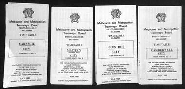
Set of 23 timetables for specific routes, day of week giving information on tram times at specific time points, route map, sections and fares and organisation address - 616 Little Collins St. Melbourne. All July 1969. The first set of timetables issued in this format. 1- Route 4 - Carnegie - City 2 - Route 5 - Malvern (Burke Rd.) - City 3 - Route 6 - Glen Iris - City 4 - Route 7 - Camberwell - City 5 - Route 8 - Toorak - City 6 - Route 9, 10 and 12 - South Melbourne and St Kilda Beach - City 7 - Routes 10, 11, 9 and 9A - West Preston Northcote - City 8 - Route 1, 2A, 15, 16 - St Kilda Beach - South Melbourne - City 9 - Route 1, 15, 21, 22 - Moreland - East Coburg - City 10 - Route 19 - North Coburg - City 11 - Route 42 - Mont Albert - City 12 - Route 48, 74 - North Balwyn - Burwood - City 13 - ditto - Saturdays and Sundays - printed on pink paper 14 - Route 55, 56 - West Coburg - Domain Road - via William St 15 - Route 57 - West Maribyrnong - City - bus route Sundays only 16 - Route 59 - Essendon Aerodrome - City 17 - Route 64, 65 - East Brighton - via Swanston St/ William St 18 - Route 69 - Kew Cotham Road - St Kilda Beach 19 - Route 70 - Wattle Park - City 20 - Route 77, 78, 79 - Prahran - City, North Richmond - Prahran - St Kilda Beach 21 - Route 82 - Footscray - Moonee Ponds - bus route Saturday afternoon and Sundays 22 - Route 88 and Route 96 - East Preston, East Brunswick - city - July 1969, printed on white paper. - Weekdays and Sundays 23 - Route 88, 96 - East Preston and East Brunswick (Blyth St)< Saturdays, Xmas day and Good Fri - printed on pink paper. 24 - Route 4D - East Malvern (Darling Road) - City, bus route Sundays only Yields information about MMTB Tram services during 1969Set of 24 MMTB Tram timetables, folded sheets.trams, tramways, mmtb, timetables, melbourne, fares, route 69, route 64, route 88, route 96, route 4, route 4d, route 5, route 6, route 7, route 8, route 9, route 9a, route 10, route 11, route 12, route 1, route 15, route 21, route 22, route 2a, route 15, route 16, route 19, route 42, route 48, route 74, route 55, route 56, route 57, route 59, route 65, route 70, route 77, route 78, route 79, route 82 -
 Melbourne Tram Museum
Ephemera - Timetable, Melbourne & Metropolitan Tramways Board (MMTB), MMTB Tram timetables, set of 12, 1971
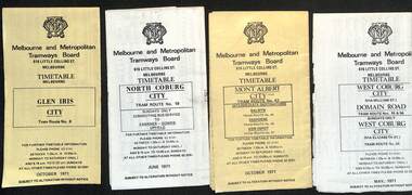
Timetables for specific routes, day of week giving information on tram times at specific time points, route map, sections and fares and organisation address - 616 Little Collins St. Melbourne. 1 - Glen Iris - City route 6 - Oct. 1971 2 - North Coburg with connecting bus to Fawkner and Gowrie - Upfield on Sundays - June 1971 3 - Mont Albert - City - routes 42, 44, 45, 37 - Oct. 1971 4 - West Coburg - Domain Road and West Coburg City on Sundays - routes 55, 56 and 68 - May 1971 5 - Essendon Aerodrome - City route 59 - June 1971 6 - East Brighton - City - routes 64, 65, 62, 61 - Oct. 1971 7 - Carnegie - City - routes 67, route 66 - Oct. 1971 8 - Wattle Park - City route 70, route 71 and route 76 - Oct. 1971 9 - Camberwell - City - route 72, route 73 - Oct. 1971 10 - Prahran - City, North Richmond -Prahran - St Kilda Beach, routes 77, 78 and 79 - Oct. 1971 11 - East Preston - City and East Brunswick - City - routes 88, 89, 90. 96 and 97 - Oct. 1971 12 - ditto for Sundays printed on green paper. 13 - Route 8, Toorak, Oct. 1971-*Yields information about 1971 MMTB timetables.Set of 12 1971 MMTB Tram timetables, folded sheets.trams, tramways, timetables, mont albert, route 42, route 6, route 19, upfield, route 44, route 45, route 37, route 55, route 56, route 68, route 59, route 64, route 65, route 62, route 61, route 67, route 66, route 70, route 71, route 76, route 72, route 73, route 77, route 78, route 79, route 88, route 90, route 96, route 97, route 8 -
 Melbourne Tram Museum
Photograph - Digital Image, Kevin O'Reilly, Kew Junction from the north east, towards the city, c1930's
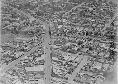
Image from CD (Compact Diskette for use in computers) - see Reg Item 135. Image titled "Kew Junction' on CD, of looking Kew Junction from the north east, towards the city, shows the Kew railway station precinct. Has a inbound W class tram picking up passengers at the Kew Post Office. A summer day. Possibly late 1920's, early 1930's.trams, tramways, kew, kew junction, kew post office, high st -
 Eltham District Historical Society Inc
Photograph, Looking north across the Fitzsimons Lane Bridge over Yarra River between Eltham and Templestowe, c.1985, 1985c
Turnoff to Candlebark Park on right. The bridge over the Yarra River was initially opened September 22nd, 1961. Newspaper reports at the time of opening stated it linked Bolton Street, Eltham, with Fitzsimons Lane, Templestowe. In 1955 the Country Roads Board (CRB) produced survey plans that showed proposed land acquisition for the future bridge and road approaches. The 1955 plan shows that it was proposed to connect Fitzsimons Lane with Bolton Street in Eltham by a diagonal road across the river. The road connection would then continue along Bolton Street to Main Road. Prior to construction of the bridge the CRB modified the proposal significantly so that there was a new road parallel with Bolton Street and then curving to join Main Road at what was then its intersection with Old Eltham Road. This involved significantly more land acquisition and altered the pattern of land subdivision through this corridor. Initially the new road was just a single two-way carriageway as it would have required a significant widening of the cutting on the Shire of Eltham side of the river. The road was officially un-named but was known locally as the Eltham-Templestowe Road. The 1966 Melway street directory and other 1960s editions also listed the road as the Eltham-Templestowe Road. In December 1970, Eltham Shire Council, in pursuance of the provisions of the Local Government Act, named it Templestowe Road. The road was renamed Fitzsimons Lane around 1984 in conformity with the section south of the river. In 1991 a new bridge was built to the west of the original bridge. Fitzsimons Lane was widened to four traffic lanes although on the Eltham side this was done within the limits of the existing cutting. NEW BRIDGE STARTS THEM EXPLORING Without any fanfares, Country Roads Board workmen on Friday afternoon put the finishing touches to the approaches, removed the barricades, and let the traffic roll over the new Yarra bridge linking Bolton Street, Eltham, with Fitzsimons Lane, Templestowe. Over the week-end many “bridge watchers” who were making one of their periodic inspections of the progress on the new bridge found to their surprise that they could drive over it, so that people who had gone for a run out to Eltham suddenly found themselves wandering through Templestowe and Doncaster. By Monday the word of the bridge’s opening had got around sufficiently for many regular travellers to the city from Eltham and beyond to vary the monotony by going to town via Templestowe and Kew instead of through Heidelberg. They were surprised at the distances – about 3 ½ miles from Eltham to Templestowe, 6 miles from Eltham Shire hall to the Lower Heidelberg Road-Banksia Street intersection. NEW NEIGHBOURS For people on both sides of the river, the new bridge has turned distant friends into near neighbours. A Greensborough man on Sunday took 35 minutes to reach the home of a friend in East Doncaster, but the return trip over the new bridge took only 17 minutes. It will be some time yet before most people work out the possibilities in shorter and quicker trips form the north-eastern areas to the eastern and south-eastern suburbs. The coming of the warmer months will soon teach many, though the short cuts to Peninsular beaches and eastern suburban drive-ins. And before very long it is likely there will be a Tramways bus running from Templestowe to Eltham station. NEW BRIDGE STARTS THEM EXPLORING (1961, September 27). The Diamond Valley News (News clipping held in SEA_74-1_047) The previously un-named road between Main Road and Yarra River, Eltham South, east of Bolton Street was named Templestowe Road, December 15, 1970 NAMING OF STREETS AND ROADS. (1970, December 15). The Diamond Valley News (News clipping held in SEA_74-2_022)Colour photographinfrastructure, shire of eltham infrastructure, bridge, fitzsimons lane bridge, yarra river, candlebark park, red nose day -
 Melbourne Tram Museum
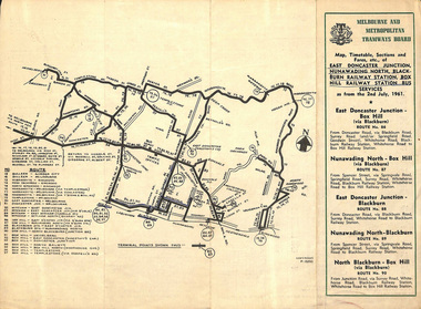
Ephemera - Timetable, Melbourne & Metropolitan Tramways Board (MMTB), East Doncaster Junction, Nunawading North, Jul, 1961
Timetables for specific routes, day of week giving information on tram times at specific time points, route map, sections and fares and organisation address - 616 Little Collins St. Melbourne. 2nd July 1961 1 - East Doncaster Junction, Nunawading North, Blackburn Railway Station, Box Hill Railway Station- Mitcham - Ringwood. 2 - Doncaster Junctioin - Melbourne - route 81 with many supplementary routes - July 1961 3 - Bulleen - City - Garden City routes 15 and 16 - July 1961Demonstrates and early MMTB timetable for bus routes which included extensive details of services.Set of 3 MMTB Bus timetable, folded sheets with maps. Bus routes underlined in blue inktrams, tramways, timetables, tickets, bus services, fares, mmtb, doncaster, ringwood, mitcham, bulleen, garden city, route 15, route 16, route 81 -
 Eltham District Historical Society Inc
Film - Video (VHS), Dynavision Video Production, 1994 Eltham Festival, 11 Nov 1994
20th Eltham Community Festival and last under the auspices of the Shire of Eltham. The Grand Parade focussing on the theme "Echoes of Eltham - Celebrating the visions of Eltrham from the past and into the future" was headed by Jock Read on his horse Lofty who had been filmed in an Anzac Day Parade on an earlier horse which had featured in the television show Matlock. The parade travelled north along Main Street to just past the Post Office then back south to Panther Place. Parade participants included 1st Eltham Brownies, 1st Eltham Venturers, 2nd Eltham Sea Scouts, 2nd Eltham Venturers, 3rd Eltham Brownies, Australian Democrats, Briar Hill Primary School, Circus Chaos, Country Fire Authority, Diamond Valley People for Disarmament, Diamond Valley Railway, Eltham Community Health Centre, Eltham District Horse and Pony Club, Eltham East Primary School, Eltham Fire Brigade, Eltham Junior Football Club (Panthers), Eltham Little Theatre, Eltham North Primary School, Eltham Playhouse Co-op, Eltham Pre-school, Eltham Roller Skating Club, Eltham South Pre-School Centre, Eltham Steam and Stationary Engine Society, Greenhills Neighbourhood House, Heidelberg Municipal Band, Hurstbridge Learning Co-op, Jocklebeary Farm, Kangaroo Ground Primary School, Learning Co-op Primary School, Lower Plenty Primary School, Main Road, Montmorency Gardening Club, Montmorency South Primary School, North Warrandyte Fire Brigade, Plenty Valley 88.6 FM, Research Pre-school, Research Primary School, Ron Sampson, Salvation Army Band (Briar Hill), Sherbourne Primary School, Shire of Eltham, State Emergency Service (Eltham) and Woodridge Pre-school. The parade commentary was provided by Plenty Valley FM 88.6 with guest commentator, Shire President Cr. John Graves. Following the parade is video footage from a helicopter of Alistair Knox Park, displays along Main Road and activities in Alistair Knox Park and the Rugby oval along with stationary engines, helicopter joyrides, Eltham People's Choir, music entertainment. Scenes also from the Diamond Valley Railway at Eltham Lower Park and finishing with the fireworks display. At the end of the video is a promotional video for Dynavision Video Production, a local video production company that produced the video and Diamond Photos (Kodak Express). One of the highlights of the festival was a tree planting ceremony in Alistair Knox Park to celebrate 123 years of the Shire of Eltham led by Shire President Cr. John Graves and representatives of the Wurrundjeri, traditional land owners of the area.VHS Video cassette (poor quality) Converted to MP4 file format 45:01, 535MB DVD copy of VHS cassette (better quality)1st eltham brownies, 1st eltham venturers, 2nd eltham sea scouts, 2nd eltham venturers, 3rd eltham brownies, 1994, aerial photographs, alistair knox park, arthur street, australian democrats, briar hill primary school, circus chaos, country fire authority, diamond valley people for disarmament, diamond valley railway, eltham community health centre, eltham district horse and pony club, eltham east primary school, eltham festival, eltham fire brigade, eltham junior football club (panthers), eltham little theatre, eltham lower park, eltham north primary school, eltham people's choir, eltham playhouse co-op, eltham pre-school, eltham roller skating club, eltham south pre-school centre, eltham steam and stationary engine society, grand parade, greenhills neighbourhood house, heidelberg municipal band, hurstbridge learning co-op, jock read, jocklebeary farm, john graves, kangaroo ground primary school, learning co-op primary school, lofty (horse), lower plenty primary school, main road, matlock police (tv show), montmorency gardening club, montmorency south primary school, nicholaus lauder estate, north warrandyte fire brigade, plenty valley 88.6 fm, research pre-school, research primary school, ron sampson, salvation army band (briar hill), sherbourne primary school, shire of eltham, state emergency service (eltham), video recording, woodridge pre-school -
 Falls Creek Historical Society
Book - The Campaign Fires - North-East/East Gippsland Fires 2003, Lyndel Hunter
A description of efforts to fight the bushfires in Gippsland in 2003, including maps and illustrations. This volume was published as a tribute to the work of staff and volunteers who put themselves at risk to protect local communities. It shows the impact on those communities in Victoria and the support they gave to those involved in fighting largest bushfires in Victoria for 60 years. The Alpine bushfires started on 8th January 2003, a day of Total Fire Ban. Lightning ignited 87 fires in the North-East and East Gippsland regions. Eight of these fires were unable to be contained; they joined together to form the largest fire in Victoria since the Black Friday fires in 1939. The majority of the area burnt in Victoria was public land, 1.19 million hectares of parks and forests, including 60 per cent of the Alpine National Park and 81 per cent of the Mt Buffalo National Park. Firefighting efforts were made difficult in hard-to-access, remote forest terrain. Approximately 90,000 hectares of private land was burnt.This book is significant because it documents the 2003 Victorian Bushfires and serves as a tribute to the CFA staff and volunteers who fought them.This publication of 119 pages features text, colour images, maps and detailed information related to the 2003 bushfires in Victoria.At bottom of front cover:- CFA Victoria Logo Victorian Government Logovictorian fires 2003, cfa (vic) -
 Wooragee Landcare Group
Photograph, 5 September 2004
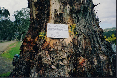
Wooragee Landcare was formed in 1989 to promote sustainable conservation and land-use practices in the North-East region of Victoria. The organisation's work has included public awareness and education campaigns to control invasive, introduced species and protect native wildlife, such as campaigns to replant native plant species to improve soil integrity and restore habitat for flora and fauna. The organisation has drawn on the work of a variety of Government and academic experts to ensure best practice approaches are utilised. This photograph was taken at Riverview Farm, Victoria on Sunday the 5th of September as part of a day trip by the Wooragee Landcare Group. The event was about looking at land use on small farms and as a social get-together for the Group. Wooragee was also researching how small landholders could run some enterprises around the time of the trip. This photograph is a great example of the type of events that Wooragee Landcare Group has organized, while educating the public about the importance of land use management.Landscape colour photograph printed on gloss paper. Reverse: WAN NA E0NA2N2. NNN+ 4 4240/ [PRINTED] (No. 24) / 377wooragee, wooragee landcare group, wooragee landcare's collection, land use, social, riverview farm, animals, pests, indigo shire, tatong, samaria, north-east victoria -
 Wooragee Landcare Group
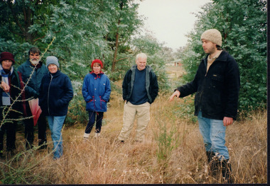
Photograph, 20th June 2004
Photo shows, (L-R): Lesley Finedon; unknown; Mary Prowse; Ann Henderson; Ray Henderson; Luke Bayley (North East CMA), assessing successful stream side rehabilitation at Bev DeJong and Bob Dunnett's place during a paddock demonstration and tree planting field day, called 'Really Successful Tree Planting!' run by Wooragee Landcare on Sunday 20th June 2004. Maintaining and reforesting native trees, shrubs and grasses are really important for a variety of reasons, including creating native habitat and food for birds and other animals, shade, biodiversity, visual appeal, cooling, shade for urban areas, sequestering carbon and conservation among other considerations. The planting must be consistent with the particular needs of the environment, such as trees or shrubs which would naturally occur and are native to the area. Tree planting demonstrations such as this one run by the Landcare Group ensures that the projects are being managed consistently with an overarching commitment to land protection and management and the best methods for best outcomes are employed.This photograph is significant as it provides evidence of a project undertaken by the Wooragee Landcare Group to educate themselves and members of the public on successful techniques needed to plant and maintain trees for replanting in the Wooragee area. The Wooragee Landcare Group has been instrumental in the co-ordination of programs relating to biodiversity protection in the local area, providing great assistance to landholders.WAN NA 0ANAON0 ANN+ 1 1636 / [PRINTED] (No.20) / 934wooragee landcare, wooragee landcare group, beechworth, landcare group, wooragee, tree planting, successful tree planting, demonstration, paddock demonstration, tree planting field day, really successful tree planting, land protection and management, land management, native trees, conservation