Showing 2491 items matching "parks and gardens"
-
 Bendigo Historical Society Inc.
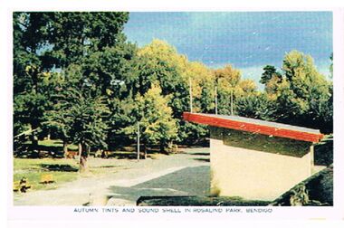
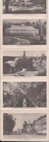
Postcard - SOUND SHELL, ROSALIND PARK
Postcard: Sound Shell in Rosalind Park, Bendigo. Image shows building with skillion roof, trees in LH and background. On bottom ' autumn tints and sound shell in Rosalind Park, Bendigo.' On back ' situated 92 miles north of Melbourne, Bendigo is the gateway to Northern Victoria. It is an attractive City with many modern facilities (unclear) Gardens and Cultural centres.'Nucolorvue Productions, No. 3, copyrightbendigo, buildings, sound shell, rosalind park, bendigo, sound shell, rosalind park -
 Bendigo Historical Society Inc.
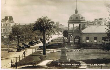
Photograph - VIEWS OF BENDIGO : NO. 17 : ROSALIND PARK GARDENS, BENDIGO : UNDATED, 1900's
Views of Bendigo. No. 17 of a series of sixteen black and white photographs of Bendigo. Nos. 6 and 7 in the series are missing. The label No. 17 is in the bottom left corner, Rosalind Park Gardens, Bendigo on the right. There is a view of the RSL Hall, looking towards View Point, with cars parked along Pall Mall. Undated, but the cars suggest 1920s/30s?bendigo, streetscape, rosalind park, bendigo parks and gardens. views of bendigo. bendigo streetscape. returned services league, bendigo. pall mall bendigo. -
 Bendigo Historical Society Inc.
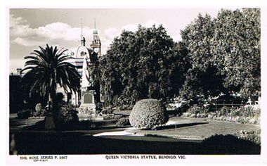
Postcard - QUEEN VICTORIA STATUE, BENDIGO, VICTORIA
black and white photo: view of Rosalind Park gardens alongside RSL war museum, showing Queen Victoria statue. On bottom of photo: The Rose Series P. 2867, Queen Victoria Statue , Bendigo, Victoria.place, public gardens, queen victoria statue, queen victoria statue, bendigo -
 Tatura Irrigation & Wartime Camps Museum
Folio, Log Buildings, 2004
Collection of reports about Love family and property at MoyolaClear plastic front cover with blue plastic back cover and blue spine. Details of establishment of Love families in the district and correspondence between Love families and "Board of Parks and Gardens" re purchase and payment for propertydocuments, biography -
 City of Kingston
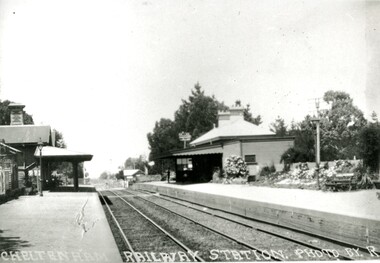
Photograph - Black and white, Percy Fairlam, c. 1920
Cheltenham station was built in 1898 and serviced a primarily rural, market gardening community.The late 1870s saw the beginning of a massive program to construct railway lines throughout Victoria. One of these lines was from Caulfield to Frankston. A survey undertaken by J P Madden, an engineer employed by the railways, established the route, although this was later modified. At the time of the official opening of the line to Mordialloc no station buildings had been constructed despite the fact that tenders had been called in the Government Gazette of 26 May 1881 and subsequently in the Argus newspaper on 30 August 1881 for what became stations at Glenhuntly, Ormond, Bentleigh, Moorabbin, Highett, Cheltenham, Mentone and Mordialloc. However platforms and sidings were completed, ready to receive passengers. Cheltenham station opened in 1898.Black and white photograph of Cheltenham Railway Station with the two platforms separated by two sets of tracks. Each platform has a station house on it, and the one on the right hand side also has a garden and park bench.Handwritten in red ink on reverse: A7 / 75%cheltenham, trains, railway, railway station, railway crossing, suburbs -
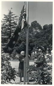 Lakes Entrance Historical Society
Photograph - Nyerimilang, East Gippsland Newspapers, 1989c
Black and white photograph of Mrs Vi Symmons nee Coate raising the flag during the Australia Day ceremony with a member of the 13th Light Horse at the flagpole in the rose garden at Nyerimilang Park Kalimna West Victoriagenealogy, symmons, celebration -
Surrey Hills Historical Society Collection
Work on paper - Vertical file, Beckett Park and Maranoa Gardens
... Beckett Park and Maranoa Gardens ...1. ‘Observation tower Beckett Park’, B.H. Reporter, 23.11.1934 (2 pages). 2. ‘Glory of a native garden’, F. Chapman, Literary Section unknown paper, 2.9.1939 (1 page, 2 copies original and copy). 3. Copy ‘Centenary tower’, The Herald, 21.5.1937 (1 page). 4. ‘Maranoa’, Camberwell City News, August, 1990 (1 page). 5. ‘Rotary Club’s gift to garden’, ? Age, 1990s ? (1 page) 6. ‘Maranoa Gardens & Beckett Park’ supplement, Boroondara Bulletin, 1997 (2 page spread). 7. ‘Beckett Park revisited’ by Annie Gillison, 8.7.1985, Melbourne Week ? (1 page). 8. Maranoa gardens Boroondara Council brochure (undated) (1 page). 9. Re Mr. Arthur J. Swaby, information from various sources, undated (1 page). 10. Beckett Park – ‘Glory of a Native Garden’, F. Chapman, unnamed newspaper, 2.9.1939, copy. (1 page). 11. Beckett Park: information re Robert Beckett from various sources (2 pages). 12. ‘Most will like gardens plan’, unnamed newspaper, letter from Dennis Whelan, undated (1 page). 13. Extracts from J.A. Allan’s unpublished history of Camberwell re Beckett Park & Maranoa Gardens, undated (1 page). 14. Maranoa Gardens Self-guided walk, undated (4 page brochure). 15. Notes on F. Chapman and interests, various sources, (2 pages). 16. Empire Day celebrations, extract from Argus, 24.5.1937 (1 page). 17. Extract from Camberwell Conservation Plan, 1989 by McConville (1 page). 18. ‘A lesson in serenity’, Maranoa Botanic Gardens, Balwyn, Domain Review, 7.7.2021 (2 pages). 19. Boroondara City Council Notice of proposed naming of reserve, Progress Leader, 5.12.2019 (1 page). 20. Maranoa Botanic Gardens, undated (double sided pamphlet). 21. 2 extracts from Box Hill Recorder, 23.10.1925 and 27.11.1925 (1 page). 22. Extract from BHR, 15.1.1926 ‘Visit of Field Naturalists Club of Victoria’ (1 page). -
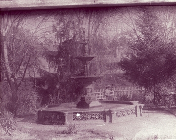 Clunes Museum
Photograph - PHOTOGRAPH QUEENS PARK
FOUNTAIN IN QUEEN'S PARK, CLUNES LADY SITTING ON GARDEN BENCH BESIDE PICKET FENCEBLACK AND WHITE PHOTOGRAPH OF FOUNTAIN IN QUEEN'S PARK, CLUNES. LADY SITTING ON BENCH.POSTCARD TO HELENA DAVIES, MARYFIELD 1909local history, photography, photographs, queen's park garden -
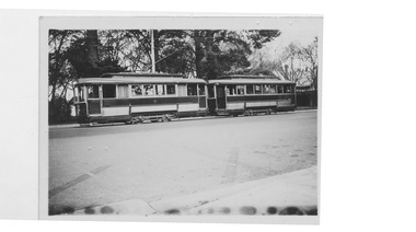 Ballarat Tramway Museum
Photograph - Tram 17 and Tram 33 - Gardens, 11/1/1954
... Gardens ...Photograph of Ballarat Tramcars 17 & 33 at Gardens, parked very close to each other.Yields information about SEC tramway operations.Black and white photograph on plain paper"6/3. 41." "cars 17 & 33 at gardens, Ballarat, Victoria." "(Destination signs show, 17, 'Victoria St'., 33, 'special'.)."ballarat, gardens, tram 17, tram 33 -
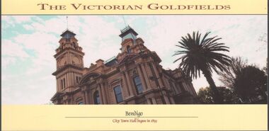 Bendigo Historical Society Inc.
Postcard - Postcards x 12
... gardens ...Colored postcards of Bendigo x 12 - Chinese Gardens, part of the Golden Dragon museum complex; Tourist Information Centre and Law Courts, formerly the old Post Office built 1887; Sunrise over Rosalind Park and the city of Bendigo; City Town Hall, begun in 1859; historic kilns at Bendigo Pottery; Water Pavilion, part of the Chinese Gardens section of the Golden Dragon Museum; Shamrock Hotel, built in 1897; shores of Lake Eppalock; view of View Street; glasshouse conservatory, part of Rosalind Park, Pall Mall; iron-work entrance to Rosalind Park conservatory; and interior of Sacred Heart Roman Catholic Cathedral of 1897.bendigo, gardens, chinese, pottery -
 Bendigo Historical Society Inc.
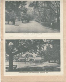
Photograph - BENDIGO PHOTO FOLDER
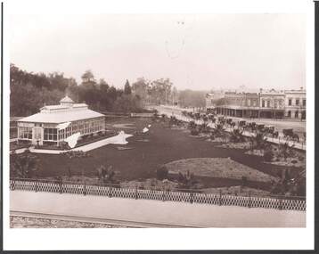
Gray covered photo folder, includes photos of Rosalind Park, Lake Weeroona boatsheds, conservatory, Pall Mall, Queens Gardens, lookout poppet head, panorama frog m lookout tower, Bendigo.Early 1900'splace, bendigo, view of bendigo -
 Bendigo Historical Society Inc.
Photograph - UNKNOWN FAMILY COLLECTION: PHOTOGRAPH
Postcards - (2 of) Rose Series, Picturesque Views of Bendigo, Australia. Two exactly the same. Rosalind Park, Lake Weeroona, The Conservatory, Pall Mall, Queen's Garden, The Lookout Tower, The Fountain and Soldier's Memorial, all Bendigo.Published by Rose Stereograph Co. Armadale.place, bendigo, picturesque views of bendigo., bendigo - views of. -
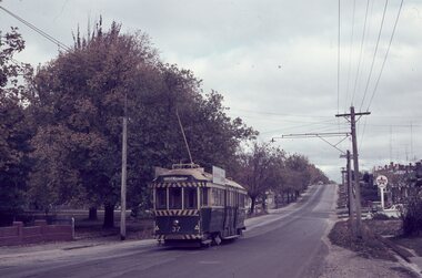 Ballarat Tramway Museum
Slide - 35mm slide/s, Robert Thomson, 28/04/1965 12:00:00 AM
Yields information about Ballarat's trams during 1965 and the Mt Pleasant line.AGFA blue / white plastic mount, colour slide of No. 37 inward bound in Barkly St Mt Pleasant, with the destination of Gardens via Drummond North. In the background is Pearce Park and a Caltex Service Station. Dated 28.4.1965"28.4.1965" in ink.tramways, trams, barkly st, mt pleasant, tram 37 -
 Surrey Hills Historical Society Collection
Photograph, Yielima, 31 Erasmus Street, Surrey Hills
Known as ‘Yielima’ 1888-1922 and ‘St. Aubins’ 1922-1956, this ‘modernized’ mansion was built about 1887 for Edward Kellett. He was born in Chorley, Lancashire, England. Edward Kellett married Selina Wells in 1852 at St Peters, Eastern Hill. She was born in c1827 in Aston Clinton, Buckinghamshire, daughter of William Wells and Elizabeth Allan. The family arrived from Aylesbury, Buckinghamshire on the 'Osprey' on 22 March 1849. The couple had 8 children - 5 girls and 3 boys; 3 died in infancy. All were born in Collingwood before the family came to Surrey Hills. Edward's funeral notice in The Argus of 11 July 1893 states that he was a corn merchant of Exhibition Street. His property was sworn at 1512 pounds, 1232 in realty and 280 pounds personally. He was buried in Melbourne General Cemetery (CofE Compartment K, No 306). Selina is listed in Erasmus Street in the 1903, 1905 and 1908 electoral rolls as a boarding house keeper. She died at Surrey Hills on 22/10/1911. In her will she left realty valued at 900 pounds and personally at 220 pounds. She was buried with her husband. 'Yielima' was sold on 19 Febraury 1919 with a sale of contents on 18 March 1919. From 1922-1947 Thomas Daniel O’Callaghan (c1871-1962), a police magistrate, made his home here. He is remembered as being of ‘soldierly demeanour, with a flowing mane of hair’. He always carried a walking stick and wore a flower in his buttonhole. His wife was Florence (nee Harling, c1873-1933) pre-deceased him. They had previously lived in Essendon, Moonee Ponds and Stawell before coming to Erasmus Street. After moving out of Erasmus Street he is listed in the 1949 and 1954 electoral rolls at 90 Durham Road, Surrey Hills. In 1952 the property was purchased by Father Timothy Fitzpatrick, Parish Priest of Our Holy Redeemer Parish, Surrey Hills. It consisted of a large two storey house, a coach house and stable, and an acre and a half of land. In 1954 the coach house and stable were converted into the Church of Our Lady of Perpetual Succour and the following year Father John Kelly was appointed parish priest. and resided in the house. At this time the house was not in good repair. "The gentleman who had lived there alone since his wife died many years before, lived in the servants quarters and the rest of the house had been badly neglected. (REF: https://ourholyredeemer.cam.org.au/history) At the beginning of 1957 the Missionary Sisters of the Sacred Heart opened a school next door. As they travelled from Balwyn on a daily basis, the property at 301 Elgar Road was purchased as a presbytery and 'Yielima' became a convent. The stables continued to be used as a church until 1964 when a new church was completed and opened by His Grace Archbishop Simmonds on the 20th of March. There were never large numbers of double-storey Victorian mansions in Surrey Hills. 'Yielma' is significant as one of the few remaining ones. It is also significant for its association with the Catholic Church.A black and white photograph of an Italianate style home with a weatherboard building with a cross on it in front of the main building and to the left of the photograph. There are some well established trees in the garden, a car parked in the parking area and a picket fence along the front.yielima, st aubins, house names, erasmus street, surrey hills, 1887, (mr) edward kellett, (mr) thomas daniel o'callaghan, corn merchant, police, italianate style, wattle park roman catholic church, (mrs) florence o'callaghan, mrs selina kellett, miss selina wells, convent, presbytery, our lady of perpetual succour -
 Buninyong & District Historical Society
Photograph - Original B/W Photograph, View over the Gong towards the Buninyong Gardens, with established trees and early model motor vehicles
... View over the Gong towards the Buninyong Gardens, with...gardens ...The photograph, taken c 1940 show The Gong and the view to the Buninyong Gardens. The trees in the Gardens are well established and early model motor vehicles are seen parked on the Gong dam wall. The Gong and the Buninyong Botanic Gardens are iconic features of the town. They are of great historic, aesthetic and social significance. They are representative of early parklands.Original B/W photograph of the view over the Gong towards the Buninyong Gardens, with established trees and early model motor vehiclesthe gong, buninyong, gardens, botanic gardens, cars, parklands -
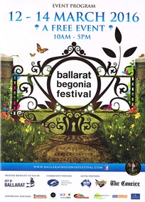 Ballarat Tramway Museum
Programme, Begonia Festival, Begonia Festival program, Feb. 2016
Full colour, A4 foldout, 8 parts, printed onto an A2 sheet, Begonia Festival program, for the 2016 Begonia Festival. Has a map with Wendouree Parade in the gardens area and shows the tram track and depot. Also shows the Park & Ride area in Victoria Park and notes the bus service from the railway (train station). Two copies held.trams, tramways, begonia festival, festival program -
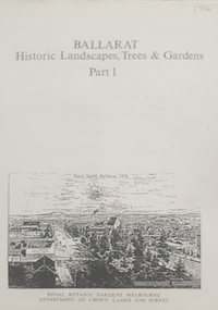 Federation University Historical Collection
Book, Peter Lumley et al, Ballarat: Historic Landscapes, Trees & Gardens, 1983, 1983
... Ballarat: Historic Landscapes, Trees & Gardens, 1983 ...Lisa Green and Lisa Morcom of Ballarat College of Advanced Educatiion contributed to this report.275 page landscape study of Ballarat including Trees in the Victorian Landscape; Plant sources early Ballarat nurseries, Botanical Gardens, Lake Wendouree, Fairy Gardens, Victoria Park, Ballaarat Old Cemetery, Eastern Oval, City Oval, Ballarat East Town Hall Gardens, Eureka Stockade, Observatory, Yarrowee, Black Hill, Sovereign Hill, Cheek Channels, Canadian Creek, Poverty Point Reserve, Goldmining Relics, Woah Hawp, Buninyong, street plantings, Russell, Victoria, Bridge Mall, Sturt Street Gardens, Avenue of Honour, Webster, Elms, ballarat, trees, nursery, r.u. nicholls, francis moss, ballarat botanical gardens, victoria park, lake wendouree, ballaarat old cemetery, eastern oval, ballarat east town hall gardens, ballarat school of mines botanical gardens, eureka stckade recreation reserve, ballarat observatory, yarrowee creek, black hill reserve, sovereign hill, ballarat avenue of honour, victoria street plantings, bridge mall plantings, george longley -
 Kew Historical Society Inc
Plan, Melbourne & Metropolitan Board of Works : Borough of Kew : Detail Plan No.1302, 1910
The Melbourne and Metropolitan Board of Works (MMBW) plans were produced from the 1890s to the 1950s. They were crucial to the design and development of Melbourne's sewerage and drainage system. The plans, at a scale of 40 feet to 1 inch (1:480), provide a detailed historical record of Melbourne streetscapes and environmental features. Each plan covers one or two street blocks (roughly six streets), showing details of buildings, including garden layouts and ownership boundaries, and features such as laneways, drains, bridges, parks, municipal boundaries and other prominent landmarks as they existed at the time each plan was produced. (Source: State Library of Victoria)This plan forms part of a large group of MMBW plans and maps that was donated to the Society by the Mr Poulter, City Engineer of the City of Kew in 1989. Within this collection, thirty-five hand-coloured plans, backed with linen, are of statewide significance as they include annotations that provide details of construction materials used in buildings in the first decade of the 20th century as well as additional information about land ownership and usage. The copies in the Public Record Office Victoria and the State Library of Victoria are monochrome versions which do not denote building materials so that the maps in this collection are invaluable and unique tools for researchers and heritage consultants. A number of the plans are not held in the collection of the State Library of Victoria so they have the additional attribute of rarity.Original survey plan, issued by the MMBW to a contractor with responsibility for constructing sewers in the area identified on the plan within the Borough of Kew. The plan was at some stage hand-coloured, possibly by the contractor, but more likely by officers working in the Engineering Department of the Borough and later Town, then City of Kew. The hand-coloured sections of buildings on the plan were used to denote masonry or brick constructions (pink), weatherboard constructions (yellow), and public buildings (grey). The absence of buildings and or property in Kew facing the Yarra is the most notable feature of this plan. Walmer Street and its bridge stretched, then and now, from Studley Park Road to Victoria Street, Richmond. On the Richmond side of the Yarra, there was evidence in 1904 of industry (‘Wool shed’; Soap Works’) and entertainment (‘Skittle Alley’). In reality, another Plan (No.1303) shows Chinese Gardens bordering the Yarra on the Kew side and buildings in Young Street.melbourne and metropolitan board of works, detail plans, mmbw 1302, cartography -
Ringwood and District Historical Society
Historical Document, Henrietta C. Walker, A House in the Foothills, 2-Mar-31
Wombolano Park was purchased by Henrietta and Frank Walker, who made many improvements to the house and garden.Article in the Australian Home Beautiful of 2-Mar-1931 about Wombolano homestead and property at Ringwood East. Pages 12,13,14,19,20,21. +Additional Keywords: Walker, Henrietta and Frank Walker"A House in the Foothills" article in The Australian Home Beautiful, 2 March 1931, pp. 12-14 and "Brick-work in the Garden" article in The Australian Home Beautiful, 1 April 1931, pp. 19-21. -
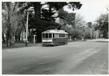 Ballarat Tramway Museum
Photograph - Black & White Photograph/s, Richard Gilbert, Late 1970
Black and white photograph of Ballarat tram No. 21 sitting in Gardens Loop in Wendouree Parade. Only two parked cars in the distance in the photograph. Taken late 1970. No. 21 has an SEC roof advertisement and destination of Mt. Pleasant. Gardens Kiosk in background. On reverse of photo is printing date "17.11.70". On Agfa paper. Photo taken by Richard Gilbert.On rear of photo in blue ink "R.Gilbert".trams, tramways, gardens loop, wendouree parade, tram 21 -
 Bendigo Historical Society Inc.
Photograph - JOHN JONES COLLECTION: CONSERVATORY GARDENS
Early photograph of the Conservatory Gardens beside the Bendigo Creek. Palm trees are very small and only one statue beside the Conservatory. A line of horse drawn vehicles are parked along the street. W. H. Oakley, Undertaker is across the street and Dimond Bros. Photo Enlargers is beside them. The Gardens are surrounded by a metal fence with a lattice like filling.place, bendigo, conservatory gardens, john jones collection - conservatory gardens, w h oakley, dimond bros -
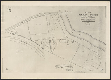
University of Melbourne, Burnley Campus Archives
Plan, Burnley Gardens. City of Richmond. Parish of Jika Jika - County of Bourke, 1927
... Burnley Gardens. City of Richmond. Parish of Jika Jika ...Plan showing Burnley Gardens - bounded by Swan St to N, Yarra River to E, Richmond Park on S and W side. Photo-lithographed at Dept of Lands & Survey by W.J. Butson. Plan shows old orchard, fowl sheds, coops and yards, milking shed, silo,nursery, glasshouse, fattening pens, gardens and orchards area in S.W. corner.burnley gardens, orchards, sheds, nursery -
 University of Melbourne, Burnley Campus Archives
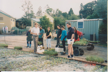
Album - Colour prints, Sandra Pullman, Miscellaneous FOBG, 1998-2000
Collection of photographs taken by Sandi Pulman of Friends of Burnley Gardens projects. (1) 30.05.1998 John Delpratt's Planting Day, Grassland Project. (2) 27.11.1999 Friends of Burnley gardens Working Bee Native Garden. (3) 22.01.2000 John Delpratt's Working Bee, Sandi Pullman, Ian Shears, Fieldstation Harvesting Grass. (4) October 2000 150th Celebrations, Ellis Stones Rockery. (5) 02.05.1998 FOBG's Working Bee Back Car Park.sandra pullman, friends of burnley gardens, fobg, john delpratt, planting day, grassland project, working bee, native garden, sandi pullman, ian shears, fieldstation harvesting grass, 150th celebrations, ellis stones rockery -
 Healesville Sanctuary Heritage Centre
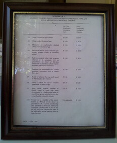
framed schedule of fees
Framed schedule of 1996 Admission Fees for Sir Colin MacKenzie Zoological Park and Melbourne Zoological Gardens. Frame is in dark brown with a gold border close to the glass. Document is printed on a single sheet of A4 paper and was possibly faxed.Typed on lower edge: "6/06/1996 3:21 PM STZOO"admission, entrance-fee, healesville-sanctuary, sir-colin-mackenzie-zoological-park, melbourne-zoological-gardens -
 University of Melbourne, Burnley Campus Archives
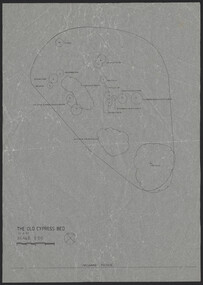
Plan, The Old Cypress Bed, 1987-1993
... gardens ...(1) Plant plan dated 15.8.1987 on tracing paper, and plan of bed only. (2) Site inventory and analysis Group 3 Parks and Gardens III August 1993, on tracing paper. (3) Rough plant plan in pencil.gardens, cypress, burnley gardens 150 year anniversary -
 University of Melbourne, Burnley Campus Archives
Photograph - Plan of Burnley Gardens
"This plan is a copy of a copy of the survey made by Mr. Turner in 1926. The original plan and field notes are missing _ file Rs 3529" Signed by _signature unreadable_ -
 Ballarat Tramway Museum
Photograph - Corner Ryrie and Garden Streets - Eastern Park, 9/1923
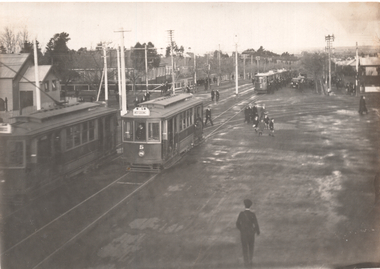
The photograph shows at least 6 six trams at Eastern Park after a football match and the Garden St junction for the East line. Tram No. 5 with a destination of West Geelong is leaving the junction. Another tram is arriving with at least four parked on the Eastern Park line. Yields information about the use of trams after a football match in Geelong.Black and white photograph with some details on rear.In ink "Cr Ryrie & Garden Sts, this type of tramcar also in service 1947" and hand date stamp of "15 Sep 1923"tramways, trams, geelong, ryrie st, garden st, eastern park, football, tram 5 -
University of Melbourne, Burnley Campus Archives
Plan, Burnley Gardens. City of Richmond. Parish of Jika Jika - County of Bourke, 1927
... Burnley Gardens. City of Richmond. Parish of Jika Jika ...Plan showing Burnley Gardens - bounded by Swan St to N, Yarra River to E, Richmond Park on S and W side. Photo-lithographed at Dept. of Lands & Survey by W.J. Butson. Plan shows old orchard, fowl sheds, coops and yards, milking shed, silo, nursery, glasshouse, fattening pens, dairy, garden, orchards area in S.W. area.burnley gardens, orchards, sheds, nursery -
 Stawell Historical Society Inc
Photograph - First Caravan Park - Botanic Gardens, Rotunda
Rotunda in first Caravan park - Botanic Gardens. Rotunda Demolished to make way for two cabins Circa 1972B/W Print of B/W photographVictorian Places -
Friends of Ballarat Botanical Gardens History Group
Work on paper - Victoria Park, Ballarat, A Brief History, Unknown
... Gardens ...Little has been researched or written about Victoria Park, by comparison with the Ballarat Botanical Gardens and Lake Wendouree.Based on the information given here, the author's conclusion is that Victoria Park is, in many ways, "the poor relation of the Botanical Gardens."2 pages of mainly short paragraphs. p.1 is blank, 2/3 of the page down.Nonejohn garner, doctor john garner, ballarat botanical gardens, friends of ballarat botanical gardens, victoria park, george longley, city night soil, the mulloch heap, trees, 2nd world war, american servicemen., gardens, ballarat, john garner collection