Showing 1360 items matching "parks and reserves"
-
 Bendigo Historical Society Inc.
Photograph - BENDIGO PHOTO FOLDER, 1920's
Rose souvenir folder containing fourteen black & white photographs Of Bendigo buildings and scenes. Pall Mall & PostOffice, Upper Reserve showing Municapal Baths, Memorial Hall & Po, Mitchell Street, The Conservatory, Lake Weeroona showing Boat houses, Pall Mall, Soldiers Memorial, Queens Gardens, Shamrock Corner, Rosalind Park, The Fernery, Pall Mall , Alexandra Fountain.Rose Stereograph Co, Armadale Vicbendigo, buildings, heritage buildings -
 City of Kingston
Photograph - Colour, 1993
Carrum is a suburb in the City of Kingston bordered by the Patterson River in the north and Kananook Creek in the south. To the east the suburb is adjacent to Patterson Lakes. The Carrum Station was opened in 1882, when the railway line from Mordialloc was extended to Frankston. In the early 20th century, it was a destination for holidaymakers occupying tents and cabins. The area now consists of older housing and over time there have been many new housing developments.Carrum is located in the area that was originally part of the Carrum Carrum Swamp. The district had originally been the home of the Bunerong people who fished, gathered food and found refuge in the sand dunes. The Swamp was drained in 1879 when the Patterson Cut was formed and became known as Patterson River. Apart from local farmers, fishermen and hotel-keepers, there were few permanent residents until the early 20th century when it had become popular as a beach resort. In the 1920s and 1930s the area became occupied by more permanent residents.Laminated aerial colour photograph of Carrum and Patterson Lakes in the City of Kingston. The photograph also includes Kananook Creek and the northern section of Seaford. Prominent features include Roy Dore Reserve, Carrum Primary School, Patterson River Secondary College, Keast Park Seaford, the Seaford Swamp Drain and a section of Downs Estate situated on the traditional lands of the Bunurong people.Black type on white adhesive sticker: No. 7140 Black type of white adhesive sticker: 31-1-93 Black handwritten ink (marker): * [an asterisk] Yellow circular adhesive stickerpatterson lakes, seaford, carrum carrum swamp -
 Bendigo Historical Society Inc.
Map - HUSTLER'S ROYAL RESERVE NO 2 CO. - LONGITUDINAL SECTION OF THE HUSTLER'S ROYAL RESERVE NO 2 CO
Longitudinal Section of the Hustler's Royal Reserve No 2 Co. on the Hustler's Line of Reef Bulletin No 33, Plate No VIII. Note - Plates 4, 8, 13, 20, 26 & 31 form a Longitudinal Section from Fortuna Hustler's to Hustler's Consols Mine. Mines mentioned are the Hustler's Royal Reserve No 2 Main Shaft, Hustler's Royal Reserve No 2 Park Shaft, Royal Hustler's, Imperial Hustler's, Great Extended Hustler's Freehold and the Great Extended. Section shows depth of levels, datum lines and height of sill above sea level yield in oz. of gold. Geological Survey of Victoria emblem. H. Herman, Director, W. Dickson, Secretary for Mines and The Hon. J. Drysdale Brown MLC, Minister for Mines and signed by H S Whitelaw, Underground Survey Office Bendigo, September 1913. mining, parish map, hustler's royal reserve no 2, royal hustler's, imperial hustler's, great extended hustler's freehold, great extended, geological survey of victoria, underground survey office bendigo, h s whitelaw, h herman, w dickson, the hon j drysdale brown -
 Bendigo Historical Society Inc.
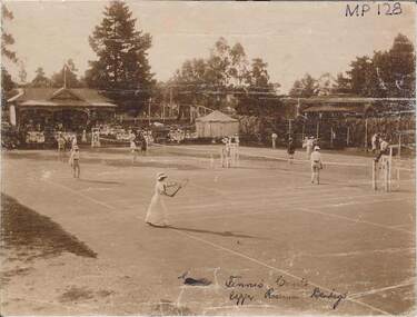
Photograph - TENNIS COURTS, UPPER RESERVE, BENDIGO
Sepia photograph of tennis players. Pavilion with backdrop of mature trees, small marquee. Males in long pants, female in long dress. Spectators seated around courts. On front written in black ink 'tennis courts, upper reserve, Bendigo' MP128 at TR corner. Asphalt tennis course situated immediately behind where the Bendigo Croquet Club is now located, Rosalind Park.place, sport, tennis courts, upper reserve, ben -
 Bendigo Historical Society Inc.
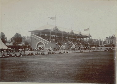
Photograph - UPPER RESERVE BENDIGO, 1900?
B+W Photograph Mounted on grey board. Upper Reserve Bendigo (Now Queen Elizabeth Oval), Showing Grandstand during event. Crowd in Stands. Sign in b/ground 'Dixons Yankee Doodle Tobacco', On end of Grandstand 'M.CONOLAN Law Courts Hotel, In left centre 'Hackland? Butcher', Park View Hotel. On Back: 'Wes Harry 28 Ellis St Bendigo'.place, sport, upper reserve/qeo -
 Eltham District Historical Society Inc
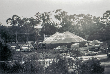
Slide - Photograph, Grace Mitchell, Ashtons Circus set up in Bremner's Reserve, Main Road, Eltham, c.1955
View from Grace Mitchell's shop at the corner of Mount Pleasant Road and Main Road. Grace Mitchell was probably best known for her Eltham shop at the corner of Mt Pleasant Road and Main Road. Grace's memories covered many local identities who were patrons of her shop between 1954 and 1971. From the elevated position of her shop and home Grace was able to view a varied passing parade of Eltham events from ERSILAC, Easter and Eltham Festival parades passing on their way to Eltham Lower Park, circuses in Wingrove Park (then Bremner’s Reserve), roadworks and other happenings. Bremner's Reserve was renamed Wingrove Park c.1970 This photo was from a series of images presented by Grace Mitchell at a Society talk 10 March 1993 on the theme of “My Eltham”.35mm Kodak 5052 TMX Black and White transparency, 1 strip, 6 frames Black and white print 17 x 25.4 cmashtons circus, bremner's flat, circus, grace mitchell, main road, mount pleasant road, wingrove park -
 Eltham District Historical Society Inc
Photograph, Grace Mitchell, Bremners Flat, Main Road, Eltham, 1958c
View from Grace Mitchell's shop at the corner of Mount Pleasant Road and Main Road. Grace Mitchell was probably best known for her Eltham shop at the corner of Mt Pleasant Road and Main Road. Grace's memories covered many local identities who were patrons of her shop between 1954 and 1971. From the elevated position of her shop and home Grace was able to view a varied passing parade of Eltham events from ERSILAC, Easter and Eltham Festival parades passing on their way to Eltham Lower Park, circuses in Wingrove Park (then Bremner’s Reserve), roadworks and other happenings. Bremner's Reserve was renamed Wingrove Park c.1970 This photo was from a series of images presented by Grace Mitchell at a Society talk 10 March 1993 on the theme of “My Eltham”.Black and white print 17 x 25.4 cmbremner's flat, main road, mount pleasant road, wingrove park -
 Eltham District Historical Society Inc
Photograph, Grace Mitchell, Diamond Creek in flood, Bremners Flat, Main Road, Eltham, c.1958
View from Grace Mitchell's shop at the corner of Mount Pleasant Road and Main Road. Grace Mitchell was probably best known for her Eltham shop at the corner of Mt Pleasant Road and Main Road. Grace's memories covered many local identities who were patrons of her shop between 1954 and 1971. From the elevated position of her shop and home Grace was able to view a varied passing parade of Eltham events from ERSILAC, Easter and Eltham Festival parades passing on their way to Eltham Lower Park, circuses in Wingrove Park (then Bremner’s Reserve), roadworks and other happenings. Bremner's Reserve was renamed Wingrove Park c.1970 This photo was from a series of images presented by Grace Mitchell at a Society talk 10 March 1993 on the theme of “My Eltham”.Black and white print 17 x 25.4 cmbremner's flat, diamond creek, floods, main road, mount pleasant road, wingrove park -
 Eltham District Historical Society Inc
Slide - Photograph, Grace Mitchell, Portable buildings on trucks possibly for installation at the Golden Fleece Service Station, corner of Main Road and Mount Pleasant Road, Eltham, c.1961
View from Grace Mitchell's shop at the corner of Mount Pleasant Road and Main Road. Grace Mitchell was probably best known for her Eltham shop at the corner of Mt Pleasant Road and Main Road. Grace's memories covered many local identities who were patrons of her shop between 1954 and 1971. From the elevated position of her shop and home Grace was able to view a varied passing parade of Eltham events from ERSILAC, Easter and Eltham Festival parades passing on their way to Eltham Lower Park, circuses in Wingrove Park (then Bremner’s Reserve), roadworks and other happenings. Bremner's Reserve was renamed Wingrove Park c.1970 This photo was from a series of images presented by Grace Mitchell at a Society talk 10 March 1993 on the theme of “My Eltham”.35mm Kodak 5052 TMX Black and White transparency, 1 strip, 6 frames Black and white print 17 x 25.4 cmgolden fleece service station, main road, mount pleasant road -
 Eltham District Historical Society Inc
Photograph, Grace Mitchell, Possibly the Ersilac Parade travelling along Main Road, Eltham, c.1958
View from Grace Mitchell's shop at the corner of Mount Pleasant Road and Main Road. Grace Mitchell was probably best known for her Eltham shop at the corner of Mt Pleasant Road and Main Road. Grace's memories covered many local identities who were patrons of her shop between 1954 and 1971. From the elevated position of her shop and home Grace was able to view a varied passing parade of Eltham events from ERSILAC, Easter and Eltham Festival parades passing on their way to Eltham Lower Park, circuses in Wingrove Park (then Bremner’s Reserve), roadworks and other happenings. Bremner's Reserve was renamed Wingrove Park c.1970 This photo was from a series of images presented by Grace Mitchell at a Society talk 10 March 1993 on the theme of “My Eltham”.Black and white print 17 x 25.4 cmcars, bremner's flat, eltham, ersilac parade, main road, mount pleasant road, wingrove park, festival, horse drawn carriage -
 Eltham District Historical Society Inc
Photograph, Grace Mitchell, Possibly the Ersilac Parade travelling along Main Road, Eltham, 1958c
View from Grace Mitchell's shop at the corner of Mount Pleasant Road and Main Road. Grace Mitchell was probably best known for her Eltham shop at the corner of Mt Pleasant Road and Main Road. Grace's memories covered many local identities who were patrons of her shop between 1954 and 1971. From the elevated position of her shop and home Grace was able to view a varied passing parade of Eltham events from ERSILAC, Easter and Eltham Festival parades passing on their way to Eltham Lower Park, circuses in Wingrove Park (then Bremner’s Reserve), roadworks and other happenings. Bremner's Reserve was renamed Wingrove Park c.1970 This photo was from a series of images presented by Grace Mitchell at a Society talk 10 March 1993 on the theme of “My Eltham”.Black and white print 17 x 25.4 cmcars, bremner's flat, eltham, ersilac parade, main road, mount pleasant road, wingrove park, festival, horse drawn carriage -
 Eltham District Historical Society Inc
Photograph, Grace Mitchell, Possibly the Ersilac Parade travelling along Main Road, Eltham, c.1958
View from Grace Mitchell's shop at the corner of Mount Pleasant Road and Main Road. Grace Mitchell was probably best known for her Eltham shop at the corner of Mt Pleasant Road and Main Road. Grace's memories covered many local identities who were patrons of her shop between 1954 and 1971. From the elevated position of her shop and home Grace was able to view a varied passing parade of Eltham events from ERSILAC, Easter and Eltham Festival parades passing on their way to Eltham Lower Park, circuses in Wingrove Park (then Bremner’s Reserve), roadworks and other happenings. Bremner's Reserve was renamed Wingrove Park c.1970 This photo was from a series of images presented by Grace Mitchell at a Society talk 10 March 1993 on the theme of “My Eltham”.Black and white print 17 x 25.4 cmcars, bremner's flat, eltham, ersilac parade, main road, mount pleasant road, wingrove park, festival, horse drawn carriage -
 Bendigo Historical Society Inc.
Photograph - WES HARRY COLLECTION: BENDIGO LANDMARKS, 1912
Group of four photographs of Bendigo Landmarks, Taken in 1912. (a) Fountain and Pall Mall, looking East, tram in the centre of the shot and the Hustlers Royal Reserve Poppet head visible to the left, (b) The law Courts with the Conservatory gardens in the foreground, (c) Statue in the Conservatory gardens, (d) shot taken from the tower of Camp Hill School, Rosalind park in the foreground, Post office and Law Courts middle distance.place, bendigo, landmarks, fountain, pall mall, hustlers royal reserve, the beehive, law courts, cons3erveratory gardens, setae, rosalind park -
 Kew Historical Society Inc
Plan - Subdivision Plan, Mount Ida Estate, 1925
The Kew Historical Society collection includes almost 100 subdivision plans pertaining to suburbs of the City of Melbourne. Most of these are of Kew, Kew East or Studley Park, although a smaller number are plans of Camberwell, Deepdene, Balwyn and Hawthorn. It is believed that the majority of the plans were gifted to the Society by persons connected with the real estate firm - J. R. Mathers and McMillan, 136 Cotham Road, Kew. The Plans in the collection are rarely in pristine form, being working plans on which the agent would write notes and record lots sold and the prices of these. The subdivision plans are historically significant examples of the growth of urban Melbourne from the beginning of the 20th Century up until the 1980s. A number of the plans are double-sided and often include a photograph on the reverse. A number of the latter are by noted photographers such as J.E. Barnes.The Mount Ida Estate was a subdivision of fifty-two residential allotments bordering Tooronga Road, Leura Grove, Constance Street, and Mount Ida Avenue in Hawthorn East. The report of the sale of the Estate in The Argus (21 September) claimed that over 1,000 people attended the auction and that all allotments were sold on the day. On the other side of Constance Street, the plan identifies the ‘Eastern Recreation Reserve’ (now Anderson Park).subdivision plans - hawthorn -
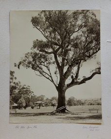
![Giant Red Gum. Victoria Park [Kew]](/media/collectors/550653872162f11fb04854aa/items/658f5e1a101c4283c6ae8194/item-media/658f5e76101c4283c6ae8404/item-fit-380x285.jpg) Kew Historical Society Inc
Kew Historical Society IncPhotograph - Giant Red Gum. Victoria Park [Kew], c.1950
In 1871, Victoria Park, beside the Boroondara General Cemetery was set aside as a public reserve. As the Park developed, exotic plants were added to existing specimens. In 1910, a photograph of ‘The Oldest Inhabitant: A Giant Red-gum Tree’ in the Park was included in the Jubilee History of Kew. Fifty-one years later the tree was re-photographed by Colin Campbell. A 2007 Master Plan developed for the City of Boroondara advises the retention of this now dead River Red Gum, including a ‘managed risk zone’ and planting under the heavily lopped tree.This work forms part of the collection assembled by the historian Dorothy Rogers (1905-1973), donated to the Kew Historical Society by her son in 2015. The manuscripts, photographs, maps, and documents were sourced by her from both family and local collections or produced as references for her print publications. Many were directly used by Rogers in writing ‘Lovely Old Homes of Kew’ (1961) and 'A History of Kew' (1973), or the numerous articles on local history that she produced for suburban newspapers. Most of the photographs in the collection include detailed annotations in her hand. The Rogers Collection provides a comprehensive insight into the working habits of a historian from the 1960s to the 1970s. Small monochrome snapshot of the former giant River Red Gum that until it died was a major feature of Victoria Park, Kew. In the background is the red brick wall of the Boroondara General (Kew) Cemetery.Annotation verso: "Giant Red Gum. Victoria Park. Still there over 100 yrs old"dorothy rogers, victoria park (kew), river red gums -
 Kew Historical Society Inc
Photograph, Colin Campbell, The Old Gum Tree, 1961
In 1871, Victoria Park, beside the Boroondara General Cemetery was set aside as a public reserve. As the Park developed, exotic plants were added to existing specimens. In 1910, a photograph of ‘The Oldest Inhabitant: A Giant Red-gum Tree’ in the Park was included in the Jubilee History of Kew. Fifty-one years later the tree was re-photographed by Colin Campbell. A 2007 Master Plan developed for the City of Boroondara advises the retention of this now dead River Red Gum, including a ‘managed risk zone’ and planting under the heavily lopped tree.‘The Old Gum Tree’ in Victoria Park. In the distance a game of cricket is being played on the oval. The old grandstand can be seen in the photo. Photographer Colin Campbell 1961. THE OLD GUM TREE / COLIN CAMPBELL KEW 1961victoria park (kew), colin campbell (photographer), victoria park, red gum tree, eucalypts, kew (vic.) -- historic trees -
 Greensborough Historical Society
Photograph - Digital Image, Pioneer Reserve 2014 -1, 21/05/2014
Pioneer Reserve, Greensborough is a small park on the corner of St Helena and Diamond Creek Roads. It is adjacent to the site of Greensborough's first bridge across the Plenty River, c. 1864 - 1960s. The shelter, viewing platform, retaining wall and entrance are built from the bridge's massive bluestone arched abutments dismantled between 1974 and 1983. Pioneer Reserve is historically significant for its formative association with noted local landscape designer Gordon Ford in 1968, and it is likely that remnant large field stones at the entrance drive to the Reserve remain from his design. Photograph by Marilyn Smith 2014.Digital copy of colour photograph. -
 Truganina Explosives Reserve Preservation Society Inc (TERPS)
Digitised Oral History – Truganina Explosives Reserve - Tape 9 Andrew Shannon and Judy Hindle, 2018
The interviews were recorded in 2000 by Bronwen Gray and Alan Young for the production of Unreserved, Stories from Truganina Explosives Reserve, animated stories from past residents, workers and interested people of the Reserve (subject to copyright 2004). Judy Hindle and Andrew Shannon worked jointly on saving the Truganina Explosives Reserve from being sold for development by the State Government. Judy was an Altona resident and Andrew was an environment planner, first with Parks Victoria and then the local council. Their motivation was to not only save the site for open space but to capture what Judy described as the only in-tact historical site in the area. A primary source of information on memories of the Truganina Explosives Reserve and Altona,VictoriaDigital copy of original cassette recorded in 2000 and digitised in 2018chirnside, explosives, tin fence, coastal vegetation, parks victoria, joan kirner, cheetham wetlands, doug grant, gahnia, salt marsh, sand ridges, rob andrew, nessie hardy, aboriginal middens, altona, truganina swamp -
 Kew Historical Society Inc
Photograph, J F C Farquhar, The Yarra in Hyde Park, 1891
At the beginning of the 1890s, the Kew businessman and Town Councillor, Henry Kellett, commissioned J.F.C. Farquhar to photograph scenes of Kew. These scenes included panoramas as well as pastoral scenes. The resulting set of twelve photographs was assembled in an album, Kew Where We Live, from which customers could select images for purchase.The preamble to the album describes that the photographs used the ‘argentic bromide’ process, now more commonly known as the gelatine silver process. This form of dry plate photography allowed for the negatives to be kept for weeks before processing, hence its value in landscape photography. The resulting images were considered to be finely grained and everlasting. Evidence of the success of Henry Kellett’s venture can be seen today, in that some of the photographs are held in national collections.It is believed that the Kew Historical Society’s copy of the Kellett album is unique and that the photographs in the book were the first copies taken from the original plates. It is the first and most important series of images produced about Kew. The individual images have proved essential in identifying buildings and places of heritage value in the district.Hyde Park is now a small recreation reserve bordered by Willsmere and Kilby Roads and White Avenue. In 1982, Hyde Park was cut off from the Yarra River by the construction of the Eastern Freeway. The building of the latter was to transform the natural landscape, including the Yarra, as well as Hyde Park. The construction of the Freeway makes it difficult to view the scene with the photographer’s eye. Today’s Hyde Park is located on land purchased in 1847 by John Cowell, and in 1851 Catherine Cowell, yet the scene selected by the photographer may well have been located on farmland owned by the Wills family. Farquhar’s point-of-view emphasises both the pastoral and recreational elements of the scene: the grazing cows, three boys, and in the distance two figures, seated on the bank with a parasol. By 1891, an environmental consequence of human activity, including farming, was deforestation, leading to the erosion of the south bank of the Yarra. In contrast, the land on the Alphington side of the river in 1891 included remnant bushland.The Yarra in Hyde Parkkew illustrated, kew where we live, photographic books, henry kellett, yarra river -
 Glen Eira Historical Society
Article - Boyd Park
... Parks ...This file contains two items. Two original photographs of Boyd Park, date unknown. An article from the CAULFIELD/ PORT PHILLIP LEADER on a massive swamp gum tree that was felled by heavy winds in Boyd Park, Murrumbeena, dated 03/08/2012.glen eira, glen eira environment group, smith colin, caine paul, boyd park, murrumbeena, parks, conservation of natural land and energy economics, reserves, bushland, gardens, resources, trees, plants -
Bendigo Historical Society Inc.
Document - Hustler Mine Sites
One page photocopy: section of a mining map, showing contour lines and mine locations of the following mines: Hustlers Royal Reserve 1775 ft Park Shaft Royal Hustlers Shaft 1150 ft Imperial Hustlers Shaft Hustlers Extended Hustler Trib Shaft 1970 ft. Great Extended Hustlers Great Extended Streets on the map: Barkly Street, Drought Street, Rosalind Street and Hope Street. -
 Bendigo Historical Society Inc.
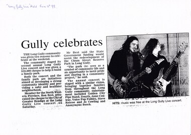
Document - LONG GULLY HISTORY GROUP COLLECTION: GULLY CELEBRATES 5 JUNE 99
Copy of a newspaper article titled Gully celebrates. The community staged its second annual Long Gully Live concert and was given a $20,00o cheque to help it building family park. Member for the North Western Province, Ron Best, presented the cheque to the City of Greater Bendigo at the Long Gully Live concert. He said the State Government funding would assist the redevelopment of the Chum Street Reserve Park in Long Gully. Entertainment included Golden City Pipe band, Zenyth, Anne Conway, Voice Pop Foibles, Steve Roscoe and Anonymous Bosch. Article includes a photo of two guitarists.bendigo, history, long gully history group, the long gully history group - gully celebrates, long gully live concert, ron best, city of greater bendigo, chum street reserve, golden city pipe band, zenyth, anne conway, voice pop foibles, steve roscoe, jo cowling, anonymous bosch -
 Robin Boyd Foundation
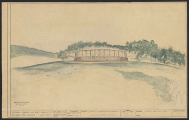
Drawing - External perspective, Tower Hill Lake Reserve Museum, Jun-61
In 1961 Robin Boyd designed the Tower Hill Reserve Visitors Centre to fit naturally within the surrounding terrain. The building’s shape reflects a volcanic cone. The windows allow a 360-degree view of the park. The Centre opened just after Robin Boyd’s death in October 1971. Project: Tower Hill Lake Reserve Museum drawn by Robin Boyd of Grounds, Romberg & Boyd. Drawing no 2. General view and external perspective. Watercolour on dyeline. tower hill, robin boyd, ohm2022, ohm2022_15 -
 Robin Boyd Foundation
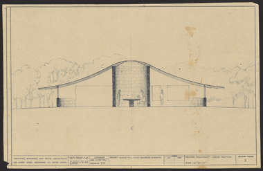
Drawing - External perspective, Tower Hill Lake Reserve Museum, Jun-61
In 1961 Robin Boyd designed the Tower Hill Reserve Visitors Centre to fit naturally within the surrounding terrain. The building’s shape reflects a volcanic cone. The windows allow a 360-degree view of the park. The Centre opened just after Robin Boyd’s death in October 1971.Project: Tower Hill Lake Reserve Museum drawn by Robin Boyd of Grounds, Romberg & Boyd. Drawing no 3. Watercolour on dyelinetower hill, robin boyd, ohm2022, ohm2022_15 -
 Melton City Libraries
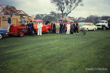
Photograph, Shire centenary, 1962
Bon Barrie, Graeme Cooper, N. Gillespie, Peter Barrie, Ken Robinson, Ray Allen, Tom Barrie, John Roaers and Graeme Gilliland, members of the Mt Cottrell Fire Brigades Group In the background of the photo is the pavilion during construction, Melton Recreation Park on Reserve Road.Melton South Trailer tank, pump and Syd Coopers Car at the Shire centenarycouncil, local significant events, emergency services -
 Eltham District Historical Society Inc
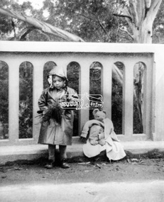
Photograph, Grace Mitchell, A young Jenni Mitchell with flowers and teddy bear on Main Road Bridge, Eltham, 1958c
Grace Mitchell was probably best known for her Eltham shop at the corner of Mt Pleasant Road and Main Road. Grace's memories covered many local identities who were patrons of her shop between 1954 and 1971. From the elevated position of her shop and home Grace was able to view a varied passing parade of Eltham events from ERSILAC, Easter and Eltham Festival parades passing on their way to Eltham Lower Park, circuses in Wingrove Park (then Bremner’s Reserve), roadworks and other happenings. Bremner's Reserve was renamed Wingrove Park c.1970 This photo of her daughter Jenni was from a series of images presented by Grace Mitchell at a Society talk 10 March 1993 on the theme of “My Eltham”. Jenni Mitchell was born 1955 according to Australian Art Sales Digest and grew up to become a noted local Eltham artist and one time Councillor.Black and white print 17 x 25.4 cmjenni mitchell, main road bridge, eltham -
 Puffing Billy Railway
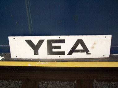
Station Sign - Yea
Station Sign - Yea Yea Station Opened 16 November 1883 Closed 8 November 1978 Yea is a former railway station in Yea, Victoria, Australia. The tracks have been removed and the reserve has been turned into The Yea Railway Park consisting of the historic railway station and eleven acres of parkland. It has a picnic shelter, barbecue, toilets, playground, skatepark, walking track, community reserve and includes Rotary Park. The station building houses Blackthorn Textiles (a privately run craft shop). Also on the site are the former goods sheds which are available for hire for varied functions. The Yea Country Market is held in the park on the first Saturday of each month and local artists hold an exhibition and sale in the goods sheds each Easter. The site is listed on the Victorian Heritage Register ref: https://en.wikipedia.org/wiki/Yea_railway_station photo at http://vhd.heritagecouncil.vic.gov.au/vhd-images/places/000/078/092.jpg Historic - Victorian Railways Station sign used at Yea StationStation Sign - Yea Metal rectangle Station Name Sign with white enamel back ground and black lettersYeapuffing billy, station sign, yea station -
 City of Ballarat
Artwork, other - Public Artwork, Col Henry, Spirit of the Forest by Col Henry, 2018
The artwork sought inspiration by the local history of Wendouree West and is a feature at the Wendouree West Recreation Reserve commissioned as part of a redevelopment of the park in 2017-2018. The artwork is located within close proximity to new playground facilities and promotes positive stories about Wendouree West to locals and the wider community.The artwork is of aesthetic significance to the people of BallaratThree stainless steel sculptures of Kurrajong tree leaves Col Henry 2018spirit of the forest, wendouree west, col henry, australian sculpture -
 Port Melbourne Historical & Preservation Society
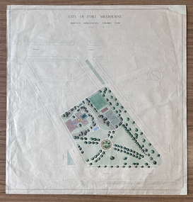
Plan - Edwards Park improvements (Trugo Green), Port Melbourne, 1940s - 1950s
Although undated, this plan is probably from the late 1940s or early 1950s. Around this time Port Melbourne Council were looking to built a basketball court in Lagoon reserve, and shelters and a senior citizen's clubhouse in Edwards Park. PMHPS does to believe the basketball court shown in the plan was built but the Port Melbourne Senior Citizens and Trugo Club is at the location shown on the plan. A shelter is in a similar location to the one on the plan. A children's playground existed in that location shown in a photograph from the 1930s. The round flowerbed where the paths cross in the centre of the park in not in the 1930s photograph but is a current feature of Edwards Park.Plan drawing to scale, hand coloured, of proposed improvements to Edwards Park (Trugo Green), undated possibly late 1940s or early 1950s."City of Port Melbourne"built environment - recreational facilities, parks and gardens, sport - trugo, port melbourne trugo club, edwards park