Showing 314 items
matching planting plan
-
 Federation University Historical Collection
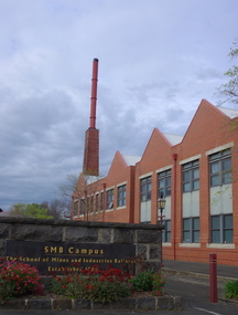
Photograph (colour), Ballarat School of Mines Brewery Building, 06/10/2011
In 1872 William Tulloch and Alexander McLaren constructed a new brick 'Royal Standard Brewery' to the design of architect Henry R. Caselli. They had been operating a much smaller 'Royal Standard' Brewery, possibly since 1859. The Ballarat Brewing Company was established in 1895 and took over operations of the 'Royal Standard'. This new company resulted in the merger of the 'Royal Standard Brewery', James Coglans 'Phoenix Brewery' (Warrenheip) and Henry Leggo's 'Barley Sheaf Brewery' (Creswick Rd). J. Coglan and W. Tulloch were principals of the new company. By 1912 the Ballarat Brewery buildings fronting Armstrong Street were upgraded and new plant installed. Ballarat Brewing Company was well established as a thriving business. In 1926 'Ballarat Bertie' (the cellar-man) advertising image was introduced. It was used successfully until 1994 on 'Ballarat Bitter' labels. During the1940s and 50s the Ballarat Brewing Company was significantly upgraded and extended equipment and buildings. In 1959 Carlton and United Breweries purchased the Ballarat Brewery, its brewing rights and the land (but not the 114 BBC hotels or the Dana Street offices). The Lydiard Street frontage become the 'front' of the CUB Brewery. CUB ceased brewing at the Ballarat Brewery site in 1989 and closed the plant. Four years later the 'brewery site' was purchased by the Ballarat School of Mines to enlarge its campus area as TAFE was a rapidly expanding areas of education. In 1994 plans were developed for the 'Brewery Complex' with careful regard for needed educational facilities and due concern regarding historical aspects of the site and its buildings. There was close consultation and cooperation with the Ballarat City Council during the planning process. In 1995 most of the Brewery buildings were demolished by some special structures and features are preserved. The old brewery chimney was retained as a permanent reminder of the original industrial site, as were two boilers. The SMB Brewery Complex was completed in 1996 and reflects aspects of the former brewery's appearance. It was opened by Prime Minister John Howard on 28 February 1997. Further details at http://guerin.ballarat.edu.au/curator/buildings/site_listing_brewery-complex.shtml Twenty five colour photographs of the Brewery Building at the University of Ballarat SMB (Ballarat School of Mines) campus. The Brewery Building is built on the site of the former Ballarat Brewery and incorporates the chimney and 'Cowley' boilers from that site. ballarat school of mines, henry richards caselli, henry caselli, ballarat brewing, brewery, beer, cowleys foundry, carlton and united breweries -
 Federation University Historical Collection
Book - Report, Former Ballarat Brewery Conservation Analysis, 1994, 1994
The former Ballarat Brewery site was purchased by the Ballarat School of Mines in 1993 who commissioned the conservation management plan. It has closed as a brewery in 1989 and the plant and fittings auctioned. The buildings were demolished and a new educational facility known as the brewery Complex was built, using some elements of the former brewery in its design. 124 page report copied onto A4 white paper, with additional appendices and definitions. Contents include brewing in Australia, site history, Tulloch & McLaren Royal Standarg Brewery, Henry Caselli, Ballarat Brewing Company, Physical Survey and comparitive analysis.ballarat school of mines, henry richards caselli, henry caselli, chimney, ballarat brewery, carlton and united breweries, tulloch and mclaren, henry r caselli, ballarat brewing company, cub, brewing tower, brew tower, boiler and engine room, cooling tower -
Federation University Historical Collection
Booklet - Report, Sturt Street Gardens, Ballarat, Victoria, Conservation and Landscape Management Plan, July 2007, 07/2007
The Sturt Street Gardens had its origins in the 1851 survey of Ballarat West by W.S. Urquhart. A generous reserve was allocated for the main streets of Ballarat, of which Sturt Street was the first. In the 1860s Sturt Street was planted with blue gums, with dual carriageway and central median Strip. Bandstands were soon erected.70 page report on the Ballarat Sturt Street gardens. The report includes an historical overview, Physical Analysis, Statement of Cultural Significance, and Consideration and Landscape Policies.queen alexandra bandstand, titanic memorial bandstand, sturt street, sturt street gardens, blue gum, statues, eight hour day memorial, boer war memorial, peter lalor statue, bluestone, bluestone guttering, william dunstan vc, time capsule, conservation management plan, landscape management plan -
Federation University Historical Collection
Document, Graeme Tyrrell, The Gardens. School of Mines and Industries, Ballarat, 10/1988
The report was prepared by Graeme Tyrrell, headgroundsman/Gardener at the Ballarat School of Mines (SMB) for Bob Feary, Manager of Facilities at SMB. Its aim was to determine the feasibility of implementing recommendations of the Conservation Analysis report (Cat. No. 8516). The report considered the following plants: Borage, Marigold, Fennel, thistle, Chamomile, Comfrey, Yarrow, Carroway, Asofoetida, Madder, Pennyroyal. Eight page report on white paper, stapled in the top left corner. Contents include purpose of the report, analysis of plants, history of garden, works programme, plans of Ballarat School of Mines (1881 and 1988) and bibliography. ballarat school of mines botanical gardens, ballarat school of mines, bob feary, graeme tyrrell, botanical garden, materia medica, botany -
 Federation University Historical Collection
Documents, J.H. Brown, Ballarat School of Mines Cyanide Plant and Caretaker's Cottage, 1914
The Ballarat School of Mines building along Albert Street were moved or demolished to make way for the new Engineering Workshop. William Henry Middleton was President of the Ballarat School of Mines from 1912 to 1940.Particulars for removal of the Ballarat School of Mines Caretaker's Quarters and Cyanide buildings are handwritten onto a foolscap page (.1). Three plans are hand-drawn in pencil, these are: (.2) Cyanide Building (.3) Caretaker's Quarters (.4) Caretaker's Quarters - South End Elevationballarat school of mines, new engineering workshop, j.h. brown, william middleton -
 Federation University Historical Collection
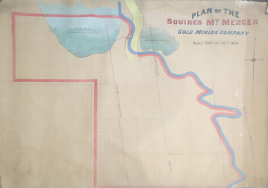
Plan, Plan of the Squires Mount Mercer Gold Mining Plant
... of the Squires Mount Mercer Gold Mining Plant Plan ...This plan is associated with former Ballarat School of Mines Student Richard Squire (1875-1876). Gift of the Squire FamilyLarge plan paper on linen, scale of 150 feet to one inch. Handcoloured. mount mercer, squires mine, mining, gold mining, gold, plan -
Federation University Historical Collection
Book, Glenfine South and South Berry Journal
This Book is associated with former Ballarat School of Mines Student Richard Squire (1875-1876). Gift of the Squire FamilyGreen water marked linen covered journal with maroon spine with red feint lined blue pages. Label on front cover is cream with black printing JOURNAL with handwritten DATA RISIS GLENFINE SOUTH -SOUTH BERRY G.S & S.B Hand written in black and red ink. Plan in back with scale 20 chains to one inch - Has an index. Handwritten on title page in black ink Address of sawmiller T. J. Brown, Mount Rowan D. W. Hambly 317 Ligar St, Ballarat J. Freeman, C/O Mrs H Simons, Lynch St, Footscray Sleemans Prescription for the bladder in 19009 Mixture No 55983 Tabloids No 55982glenfine south, south berry, sleemans, mining, gold mining, glenfine consols, reef, weights of quartz, blacksmiths tools, australian and eagle, davies south east reef drive, brawns, eaglehawk junction, simons letter, machinery, puddlng plant, poppet heads, winding plant, creswick, mosquito creek, frenchmans gully, spring hill, a. h. welsh, squire, petticoat gully -
 Federation University Historical Collection
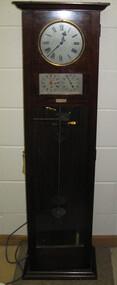
Object, Synchronome Co. Ltd, Synchronome Frequency Checking Master Clock No. 2191, c1930
Information from Norman F. Dalton: Ballarat had a reticulated DC supply in the early part of last century and in 1905 had sufficient generating capacity to enable the trams to be changed from horse drawn to DC electricity. The use of electricity increased with the main power station located on Wendouree Parade, near Webster Street, under the ownership of The Electric Supply Company of Victoria. AC generating plant was installed in 1925 and conversion to AC proceeded. In 1934 the company was taken over by the State Electricity Commission Victoria (SECV) and more AC generation was installed and the changeover of customers was accelerated. This is around the time that the Synchronome Frequency Checking Mast Clock was installed at the Wendouree Parade Power Station. The SECV Annual Report of 1921 states: ::Section 11 of the act directed the COmmission to enquire into the question of securing the adoption of such standards of plant and equipment of a system, frequency and pressure for the generation and distribution of electricity as will admit of the efficient interconnection of undertakings throughout the State. In 1934 when the SECV took over the Ballarat operations the question of linking with the State grid had been a planned operation for some years but due to financial considerations had hindered it and in fact would continue to do so for a further 10 years. So while the need for close frequency control for interconnection was hardly an issue, the need to keep electric clocks correct was important, particularly as this item was a frequent sales point to cover the inconvenience and sometimes expense of converting from DC to AC. The clock is a very accurate pendulum clock with provision for varying effective length during operation for precise time regulation. There are two normal time dials and one is controlled by the pendulum and the other is operated by the system frequency. When the clock was in use it was installed by the MEter and Tests Laboratory and the time was checked daily by radio time signals. The two dials were repeated in the operators control panel in the Power Station. A maximum deviation between the two dials was set in the operating instructions (eg 5 seconds) and the operator would correct this when necessary by remote manual alteration of the turbine governor set point. The clock was used to drive and regulate a system of "slave" clocks which were used to display the time in various locations around the power station. A slave clock is a simple clock which is driven by a small electric motor, its accuracy is regulated by the master clock every 30 seconds to ensure that it and all the other slave clocks in the station are on exactly the right time; slave clocks were placed in various locations, from common rooms to workshops. A master clock could potentially run thousands of slave clocks at one plant. The clock also contains a rectifier. A rectifier is a device that is used to convert AC power to more stable DC current.Two clocks in a timber case. Both are electric, one is powered by the main pendulum mechanism, the other is a self contained electric clock. The main mechanism is of the gravity arm and roller type, which sends an impulse to the slave clocks every 30 seconds. The This Synchronome Frequency Checking Master Clock was used at the Ballarat Power Station. Below the main section of the case is a smaller cabinet containing a rectifier to provide consistent DC power for the clock. The rectifier was made by the Victorian company Hilco, which was located in Burwood. There is a high chance this is not the original rectifier from this clock as there appears to be brackets to hold a larger device in the space the rectifier occupies.Front below main clock face on front of case: "Patented Sychronome Brisbane" Lower left-hand clock face: "Frequency time" Lower right-hand clock face: "Standard Seconds" Synchronous electric clock mechanism on door (Frequency time clock): >200/250 V. 50~ >"Synchronomains" Made in England >Direction indicator for clock starting switch >"To start move lever in direction of arrow and release" >"Patent applied for" Mechanism for "standard seconds" clock: >"English Made" >"Patented" >Serial number "321" >0 above right-hand pillar on front-plate Mechanism for "standard seconds" clock: >"English Made" >"Patented" >Serial number "321" >0 above right-hand pillar on front-plate Mechanism for main clock face: >"English Made" >"Patented" >Serial number "8751" >0 above right-hand pillar on front-plate Inside case, back panel, top enamel plate: >Seconds Battery + Pos. > Battery Common or - Neg. >1/2 min dials Inside case, back panel, bottom enamel plate: external seconds dial Inside case, right hand side, electrical knobs: two switches, both "A.C. mains" Pendulum rod, below suspension spring: Serial number (?) 0000005 Rectifier in bottom cabinet: >"Hilco Rectifier" >"A.C. Volts 230/240" >"Model 1060/S" >"A.C. Amperes" >"Serial No. 1060/S >"Phases 1" >"D.C. Volts 6" >"C.P.S. 50" >"D.C. Amperes 1" >"Made in Australia by Hilco Transformers McIntyre St., Burwood, Victoria." Bakelite electrical plug: makers mark Lower cabinet, RH side panel, pressed tin plate: "AC" (upside down) Brass speed adjustment, outer right RH side: "S" and "F" Ivory and wood pendulum beat ruler: >Ruler, with 0 in centre and numbers 1-5 in ascending order from centre on left and right. > "Synchronome Patent." Steel plate, back panel, inside case, right hand side: >N R A" (descending) >"2191" serial number/part number Face of main clock: "Synchronome Electric" synchronome frequency checking master clock, electricity, state electricity commission, wendouree parade power station, secv, clock, time, pendulum, electric supply company of victoria, norman f. dalton, ballarat power station, rectifier, slave clock -
 Federation University Historical Collection
Plan, Ballarat Technical Art School Plan of Proposed Fittings, 1914, 05/03/2014
The Ballarat Technical Art School was a division of the Ballarat School of Mines. A custom built building was opened in 1915. A plan on linen showing the proposed fittings for the new Ballarat Technical Art School Building built in the grounds of the Ballarat School of Mines. The plan has been hand coloured and designates rooms for freehand and plant drawing, model and cast drawing, Modelling Room, Light and Shade Room, Lecture room, Head Master's Office, attendant's office, cloakroom, storeroom, Castings Room, Sheet 7 W.J.G. 5.3.14ballarat technical art school, buildings, ballarat school of mines, plan -
 Federation University Historical Collection
Plan, Plan for the Ballarat Technical Art School, c1914, 05/04/1913
The Ballarat Technical Art School building opened in 1915. It was a division of the Ballarat School of MinesPlanes for the Ballarat Technical Art School basement and ground floor, featuring hand coloured sections. Wood Carving and Metal Working were located in the basement. Scale is 8 feet to 1 inch School of Mines Ballarat New Art School C.B.G.5.4.13ballarat school of mines, ballarat technical art school, plan, buildings, metalwork, wood carving, freehand and plant drawing, model and cast drawing, lecture room, modelling room, light and shade, architectural drawing -
 Federation University Historical Collection
Magazine, Greenhill Enterprise Centre Magazine
This magazine was probably a supplement of the Ballarat Courier at the time of the opening of the Greenhill Enterprise Centre, Ballarat Technology Park. 31 October 1997 - Official opening of Greenhill Enterprise Centre by the Hon. Alan Stockdale, Treasurer and minister for multimedia. Coloured magazine of 18 pages relating to the Greenhill Enterprise Centre. Contents include: * What is an enterprise Centre? * Ballarat well placed to be regional IT leader * Alan Stockdale to open Greenhill Enterprise Centre * Push to create 6000 IT jobs by year 2010 * Internet to bring world to Ballarat * Boost for Remote Schooling * Keeping on track with OZtrack * Ozdate improves methods of data collection * Benefits in university and IBM relationship * Centre for Rural and Regional Information One of first tenants. * IT exchange program to benefit university students * Complementing the environment. * IBM Global first firm to invest in Ballarat Technology Park * University art on show at IBM Images include: * Professor David James and Premier Jeff Kennett planting a tree to mark the State Government's Support for the Greenhill Enterprise Centre * Vincent Chrisp's Architects impression of the completed Greenhill Enterprise Centre * Ballarat City Executive Director of Economic development, David Miller, at the Town Hall. *Greenhill Enterprise Centre floor plan * Associate Professor Gerry Anderson * Paul Kelly * Leanne Woodartgreenhill enterprise centre, ballarat technology park, stockdale, vincent chrisp, david james, geoff kennett, david miller, a.w. nicholson, gerry anderson, peter reid, oztrak, ozdata, centre for rural and regional information, ibm global services centre, michael chrisp, oswego state university, new york, peter biznet, ibm -
 Federation University Historical Collection
Architectural Drawing, Ballarat School of Mines Ore Treatment Laboratory, 1900, 1900
The Ballarfat School of Mines Mining Plant and Laboratory were formally handed over on 23 May 1902Ground floor plan of ore laboratory drawn on coated cotton cloth, hand colouring Drawing No 3. Initialed "C.B.A. Jan 1900) H [Illegible} 31 1 00smb ore treatment laboratory, mining, ballarat school of mines, department of public works victoria, architecture, plan, laboratory, ore sampling floor, furnace, boiler house engine bed, gaol ground, ballarat gaol ground, laboratory -
 Federation University Historical Collection
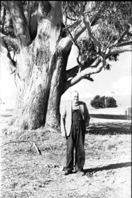
Photograph - black and white, Mr Downing by the Federation University Tree of Knowledge, 1970
Federation University Mount Helen Campus was open to students in 1970. In that year Mr Dowling as photographed beside a big Tasmanian bluegum which was used a the centre Mount Helen Campus concept plan, and later became known as the Tree of Knowledge. Mr Dowling watered the tree after it was planted by his mother, Elizabeth Downing, on Arbour Day 1896. Mrs Downing raised her large family on the site of the Mount Helen Campus, which included an orchard and milking cows. The Tree of Knowledge is actually two trees, the trunks have fused together over time, and there is further evidence of fusion. The Downing farmhouse was situated in the vicinity of the present Administration and Caro Conference Centre buildings and the tree was planted beside the "dunny". It was carefully watered by the nine Downing children from a brick-lined well situated under what is now the Albert Coates Building. As the tree grew to maturity, it was used to hang a meat safe after slaughtering a sheep for the family table. Some years ago, when the foundations were being dug for the E-Building, an old rusted percussion pistol was found. One of Mrs Downing's sons, at that time well into his nineties, remembered getting into trouble for playing with it without permission, and losing it. The land was purchased in 1966 as part of a 241-acre site for Ballarat's new tertiary institution. When the architects and planners inspected the site, they decided "The Big Tree" must remain as a central landmark in preparing the layout of the campus amenities. In 1982, the spread of the tree was 36 metres, girth 7 metres, and height 36 metres. By 2003 the spread was 39.5 metres (N-S) and 35.5 metres (E-W), girth 7.75 metres, and height 42.5 metres. A man in overalls and jacket stands beside the Federation University Tree of Knowledge. Stage one buildings on the Mount Helen Campus are evident in the background.elizabeth downing, downing, tree of knowledge, big tree, mount helen campus, mount helen -
 Flagstaff Hill Maritime Museum and Village
Clock, 1950
Westclox had a highly successful factory in Scotland situated in the Vale of Leven Industrial Estate, in Dumbarton, around twenty miles from the City of Glasgow. Westclox had originally planned to start production in Scotland in 1939 but the War intervened and it was not until 1948 that they were able to fully commission their factory in Dumbarton. Westclox Scotland produced its first clock on the 21st September 1948; a spring wound alarm with a 4 inch dial. The Westclox factory in Scotland was a full manufacturing plant with all their clocks assembled from start to finish with only the basic raw materials being brought in by outside suppliers. 95% of the staff were local people and the firm trained their employees from scratch to a high level of skill and had an annual apprenticeship for toolmakers and classes in horology. By 1949 Westclox Scotland were making 10,000 clocks a week, and by 1950, 1,000,000 clocks had been produced since its opening. No home in the Dunbartonshire Vale was without at least one Westclox clock, nor any raffle complete without a clock as one of the prizes! Many of these clocks are still around today. So successful was the Dumbarton factory that in the mid 1950’s Westclox had to expand into adjoining buildings. The factory then added watches to what they made as well as timing devices for other sectors. By the mid 1960’s, employment levels at the Scottish plant were around 1100. Over a third of the clocks manufactured in Scotland were exported to some 110 countries across the globe. Difficult times came in 1967/68 when 400 workers were laid off and the future of the plant was in doubt primarily due to cheap clocks from the then communist countries. However, strong petitions to the UK Government produced the passing of an anti-dumping law allowed production from the factory to pick up. In 1968 General Time was bought out by Talley Industries, which was best known as a manufacturer of timing equipment, such as factory time clocks to various industries. Westclox in Scotland enjoyed several boom years under the then Managing Director, John Santos. Westclox Scotland in October 1974 hosted a Space Seminar for the Astronaut, Neil Armstrong and British Astronomer, Sir Patrick Moore. Both visited the Scottish factory to promote the introduction of Quartz time-keeping. In 1976 the Westclox plant in Dumbarton became the Headquarters of General Time (International Operations) Ltd. John Santos retired from General Time and Westclox in the early 1980s and by 1988 the future of Westclox in Scotland was almost over. The advent of Quartz clock technology, developed largely by General Time for use in the Apollo 11 Command Module, resulted in the reduction of mechanical clock production and sales, and the factory fully closed in 1988.The Westclox factory building in Dumbarton has been converted and is now home to many thriving small businesses. The item marks a time when clock production in the United Kingdom was at it’s peak producing clocks for sale in over a 110 countries, they were keenly priced and available to all. The company had many innervation's during it’s life regards clock and later wrist watch making. In 25 years the factory had produced over 50 million clocks, yet it was perhaps inevitable with the advent of Quartz technology that was ironically evolved, largely by General Time for use in the Apollo 11 Command space Module, that would ultimately herald the end of the mechanical clock.Wooden bedroom alarm clock small painted brown with a criss cross pattern in gold and a white enamel face roman numerals & a glass front, clock case is of a fancy design. Inscribed on face "Made by Westclox Ltd Scotland" .flagstaff hill, warrnambool, shipwrecked-coast, flagstaff-hill, flagstaff-hill-maritime-museum, maritime-museum, shipwreck-coast, flagstaff-hill-maritime-village, clock mantle, clock, mantle clock, westclox ltd, horology, clock industries -
 Federation University Historical Collection
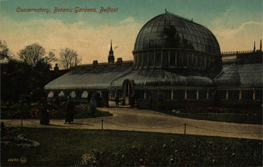
Postcard - Colour, Walton, Conservatory, Botanic Gardens, Belfast, Ireland
The gardens' most notable feature is the Palm House conservatory. The foundation stone was laid by the Marquess of Donegall in 1839 and work was completed in 1840.[4] It is one of the earliest examples of a curvilinear cast iron glasshouses in the world. Designed by Charles Lanyon and built by Richard Turner, Belfast's Palm House predates the glasshouses at Kew and the Irish National Botanic Gardens at Glasnevin, both of which Turner went on to build. The Palm House consists of two wings, the cool wing and the tropical wing. Lanyon altered his original plans to increase the height of the latter wing's dome, allowing for much taller plants. The Palm House also features a 400-year-old Xanthorrhoea. (Wikipedia)A coloured postcard showing a large glasshouse standing in the middle of Belfast Botanic Garden.chatham family archive, belfast, garden, ireland, glasshouse, belfast botanic garden, palm house -
 Federation University Historical Collection
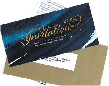
Invitation, Invitation to Attend a Luncheon with HRH Prince Edward at Federation University Mt Helen Campus, 2018, 2018
Federation University Australia showcased its students and research at a luncheon for His Royal Highness The Prince Edward, Earl of Wessex KG GCVO, at the Mt Helen Campus on Sunday, 8 April. The University’s student leaders and academics joined other dignitaries and business representatives for the special event. “The University is deeply honoured to host HRH The Earl of Wessex and share his passion for volunteerism and The Duke of Edinburgh’s International Award,” Professor Helen Bartlett, Vice-Chancellor, said. Prior to the luncheon HRH The Earl of Wessex experienced a Welcome to Country and Smoking Ceremony at the University. The program included showing HRH The Earl of Wessex concept plans for a refurbished Sports Science facility at the Mt Helen Campus. Guests were treated to a performance by the Arts Academy’s renowned vocal ensemble Word of Mouth. At the conclusion of the luncheon, HRH The Earl of Wessex planted a tree at the Student Commons Courtyard. The visit to the University by HRH The Earl of Wessex was the first by a member of the Royal Family since Prince Charles visited in 1974. HRH The Earl of Wessex was in Australia to attend the Commonwealth Games and undertake additional engagements to recognise and promote The Duke of Edinburgh’s International Award in Australia. HRH The Earl of Wessex, who is the Chair of The Board of Trustees of The Duke of Edinburgh’s International Award Foundation, attended 32 engagements across Melbourne, Ballarat, Hobart, Brisbane, and Adelaide, from formal receptions, Award presentations, meetings with government officials and the community sector, to meeting Award Participants and their families at community centres. The events enabled HRH The Earl of Wessex to engage with over 1,000 young people undertaking the Award, and over 3,400 Award volunteers and supporters who will have the opportunity to discuss their activities and showcase the work being done to help young Australians dream big, challenge themselves and find their purpose, passion and place in the world. HRH The Earl of Wessex’s visit celebrates significant milestones and growth in the diversity of The Duke of Edinburgh’s International Award program in Australia. “The Award’s relevance to all young Australians is as important today as it was when it started over 60 years ago,” Mr Peter Kaye AM, Chief Executive Officer of The Duke of Edinburgh’s International Award – Australia, said. “Employers in particular are recognising the ‘soft skills’ that are so necessary for a well prepared future employee.”Invitation and dress code in a gold envelope. Addressed "Ms Clare Gervasoni Curator, Art & Historical Colelctions Federation University Australia Mt Helen Campus"prince edward, earl of wessex, helen bartlett, visitors, royal visit -
 Federation University Historical Collection
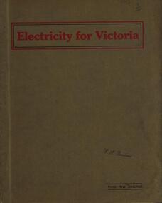
Book, Electricity for Victoria, 1927, 1927
Brown soft covered book. Contents include: Winning Brown Coal at Yallourn Dredge Operation for Overburden Removal Boiler Plant at the Yallourn Power Station Electrical Equipment at the Yallourn Power Station Steam Plant at the Yallourn Power Station Yallourn-Melbourne High Tension Line Yarraville Terminal Station Transmission distribution High Transmission Towers for River Crossing Sugarloaf-Rubicon Hydroelectric Development Briquette factory Subsidiary Activities at Yallourn Future Developments thompson's engineering & pipe co. ltd, briquettes, electricity, power generation, yallourn, yallourn briguetting works, transmission lines, high tension switchgear, insulators, australian porcelain company, substation, brown coal, high tension line, sugarloaf-rubicon, plans, suspension tower, transposition tower, yarraville terminal station, condenser, newport power station, gippsland, hydroelectric -
 Federation University Historical Collection
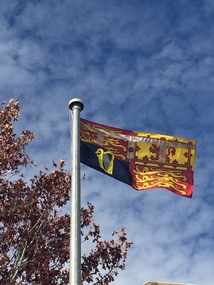
Photograph - Photograph - Colour, Suzanne Godfrey, The Royal Standard Flying at Federation University Mt Helen Campus, 2018, 09/04/2018
Federation University Australia showcased its students and research at a luncheon for His Royal Highness The Prince Edward, Earl of Wessex KG GCVO, at the Mt Helen Campus on Sunday, 8 April. The University’s student leaders and academics joined other dignitaries and business representatives for the special event. “The University is deeply honoured to host HRH The Earl of Wessex and share his passion for volunteerism and The Duke of Edinburgh’s International Award,” Professor Helen Bartlett, Vice-Chancellor, said. Prior to the luncheon HRH The Earl of Wessex experienced a Welcome to Country and Smoking Ceremony at the University. The program included showing HRH The Earl of Wessex concept plans for a refurbished Sports Science facility at the Mt Helen Campus. Guests were treated to a performance by the Arts Academy’s renowned vocal ensemble Word of Mouth. At the conclusion of the luncheon, HRH The Earl of Wessex planted a tree at the Student Commons Courtyard. The visit to the University by HRH The Earl of Wessex was the first by a member of the Royal Family since Prince Charles visited in 1974. HRH The Earl of Wessex was in Australia to attend the Commonwealth Games and undertake additional engagements to recognise and promote The Duke of Edinburgh’s International Award in Australia. HRH The Earl of Wessex, who is the Chair of The Board of Trustees of The Duke of Edinburgh’s International Award Foundation, attended 32 engagements across Melbourne, Ballarat, Hobart, Brisbane, and Adelaide, from formal receptions, Award presentations, meetings with government officials and the community sector, to meeting Award Participants and their families at community centres. The events enabled HRH The Earl of Wessex to engage with over 1,000 young people undertaking the Award, and over 3,400 Award volunteers and supporters who will have the opportunity to discuss their activities and showcase the work being done to help young Australians dream big, challenge themselves and find their purpose, passion and place in the world. HRH The Earl of Wessex’s visit celebrates significant milestones and growth in the diversity of The Duke of Edinburgh’s International Award program in Australia. “The Award’s relevance to all young Australians is as important today as it was when it started over 60 years ago,” Mr Peter Kaye AM, Chief Executive Officer of The Duke of Edinburgh’s International Award – Australia, said. “Employers in particular are recognising the ‘soft skills’ that are so necessary for a well prepared future employee.”Photograph of the Royal Standard Flying on the Federation University Mt Helen Campus flagpoles during the visit of HRH the Prince Edward, Earl of Wessex, KG GCVO. Prince Edward visited the Mount Helen campus as the Chair of the trustees of The Duke of Edinburgh's International Award Foundation. The award is the world's leading youth achievement award. It has helped inspired, empower, connect and recognise the achievements of more than 8 million young people in more than 140 countries. The Award presents a balanced, non-competititive program of voluntary activites that encourage personal discovery, growth, resilience, perseverance, responsibility and community service. It is about individual challenge and encouraging young people to become mature and active citizens who positively contribute to society, through activities that inspire them.prince edward, earl of wessex, royal visitor, duke of edinburgh's international award foundation, federation university, royalty -
 Federation University Historical Collection
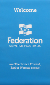
Poster, Federation University Australia Welcome to HRH Prince Edward, 2018, 09/04/2018
Federation University Australia showcased its students and research at a luncheon for His Royal Highness The Prince Edward, Earl of Wessex KG GCVO, at the Mt Helen Campus on Sunday, 8 April. The University’s student leaders and academics joined other dignitaries and business representatives for the special event. “The University is deeply honoured to host HRH The Earl of Wessex and share his passion for volunteerism and The Duke of Edinburgh’s International Award,” Professor Helen Bartlett, Vice-Chancellor, said. Prior to the luncheon HRH The Earl of Wessex experienced a Welcome to Country and Smoking Ceremony at the University. The program included showing HRH The Earl of Wessex concept plans for a refurbished Sports Science facility at the Mt Helen Campus. Guests were treated to a performance by the Arts Academy’s renowned vocal ensemble Word of Mouth. At the conclusion of the luncheon, HRH The Earl of Wessex planted a tree at the Student Commons Courtyard. The visit to the University by HRH The Earl of Wessex was the first by a member of the Royal Family since Prince Charles visited in 1974. HRH The Earl of Wessex was in Australia to attend the Commonwealth Games and undertake additional engagements to recognise and promote The Duke of Edinburgh’s International Award in Australia. HRH The Earl of Wessex, who is the Chair of The Board of Trustees of The Duke of Edinburgh’s International Award Foundation, attended 32 engagements across Melbourne, Ballarat, Hobart, Brisbane, and Adelaide, from formal receptions, Award presentations, meetings with government officials and the community sector, to meeting Award Participants and their families at community centres. The events enabled HRH The Earl of Wessex to engage with over 1,000 young people undertaking the Award, and over 3,400 Award volunteers and supporters who will have the opportunity to discuss their activities and showcase the work being done to help young Australians dream big, challenge themselves and find their purpose, passion and place in the world. HRH The Earl of Wessex’s visit celebrates significant milestones and growth in the diversity of The Duke of Edinburgh’s International Award program in Australia. “The Award’s relevance to all young Australians is as important today as it was when it started over 60 years ago,” Mr Peter Kaye AM, Chief Executive Officer of The Duke of Edinburgh’s International Award – Australia, said. “Employers in particular are recognising the ‘soft skills’ that are so necessary for a well prepared future employee.”Blue Federation University poster created to welcome HRH Prince Edward to the Mount Helen Campus poster, banner, prince edward, royal visitor -
 Federation University Historical Collection
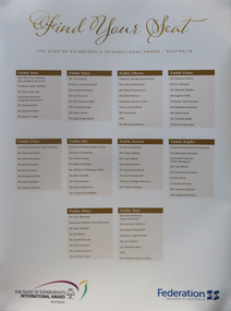
Photograph - Colour, Clare Gervasoni, Federation University Seating Arrangement for lunch with HRH Prince Edward, 2018, 09/04/2018
Federation University Australia showcased its students and research at a luncheon for His Royal Highness The Prince Edward, Earl of Wessex KG GCVO, at the Mt Helen Campus on Sunday, 8 April. The University’s student leaders and academics joined other dignitaries and business representatives for the special event. “The University is deeply honoured to host HRH The Earl of Wessex and share his passion for volunteerism and The Duke of Edinburgh’s International Award,” Professor Helen Bartlett, Vice-Chancellor, said. Prior to the luncheon HRH The Earl of Wessex experienced a Welcome to Country and Smoking Ceremony at the University. The program included showing HRH The Earl of Wessex concept plans for a refurbished Sports Science facility at the Mt Helen Campus. Guests were treated to a performance by the Arts Academy’s renowned vocal ensemble Word of Mouth. At the conclusion of the luncheon, HRH The Earl of Wessex planted a tree at the Student Commons Courtyard. The visit to the University by HRH The Earl of Wessex was the first by a member of the Royal Family since Prince Charles visited in 1974. HRH The Earl of Wessex was in Australia to attend the Commonwealth Games and undertake additional engagements to recognise and promote The Duke of Edinburgh’s International Award in Australia. HRH The Earl of Wessex, who is the Chair of The Board of Trustees of The Duke of Edinburgh’s International Award Foundation, attended 32 engagements across Melbourne, Ballarat, Hobart, Brisbane, and Adelaide, from formal receptions, Award presentations, meetings with government officials and the community sector, to meeting Award Participants and their families at community centres. The events enabled HRH The Earl of Wessex to engage with over 1,000 young people undertaking the Award, and over 3,400 Award volunteers and supporters who will have the opportunity to discuss their activities and showcase the work being done to help young Australians dream big, challenge themselves and find their purpose, passion and place in the world. HRH The Earl of Wessex’s visit celebrates significant milestones and growth in the diversity of The Duke of Edinburgh’s International Award program in Australia. “The Award’s relevance to all young Australians is as important today as it was when it started over 60 years ago,” Mr Peter Kaye AM, Chief Executive Officer of The Duke of Edinburgh’s International Award – Australia, said. “Employers in particular are recognising the ‘soft skills’ that are so necessary for a well prepared future employee.”Photograph of the seating arrangements for the dinner with HRH Prince Edward at Federation University Mount Helen Campus poster, prince edward, royal visitor, seating arrangement -
 Federation University Historical Collection
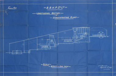
Plan, Blueprint B.B.H.P. Co Ltd Longitudinal Section of Concentrating Plant, 1895
... Longitudinal Section of Concentrating Plant Plan Plan ...Blueprint plan by H.L. Hancock blueprint, h. l. hancock, longitudinal section, concentrating plant, bhp -
Federation University Historical Collection
Report, Port Fairy: Environmental/Physical Plan, 1999, 11/06/1999
Report compiled by fivestudents of Tourism at University of Ballarat (later Federation University Australia)victorian tourisim industry, tourism, port fairy, alumni, port fairy folk festival, griffith island, portland, pea soup, mott's cottage, mill's cottage, port fairy lighthouse, moyne river -
Federation University Historical Collection
Booklet, Little Desert National Park and Wail State Forest Proposed Management Plan, 1991, 11/1991
Grey soft covered report of 80 pages. Includes a pull out map.little desert national park, wait state forest, management plan, horsham, department of conservation and environment, rod gowans, don spence, wimmera river, threatened plants, fauna, flora, birds, mammals, wergaia, scarred trees, mounds, pest plants, pest animals, tourism and recreation, timber, grazing, conservation -
 Federation University Historical Collection
Booklet, South Australian School of Mines and Technological Museum Annual Report, 1909, 1909
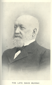
.3) South Australian School of MInes and Technological Museum Annual Report for 1908 and Prospectus for 1909. Includes images of the School Council (H. Adams, E.A. Roberts, E.W. Van Senden, Hon. Sir J. Langdon Bonython, Hon. Sir F.W. Holder, Hon. D.M. Charleston, Professor W.H. Bragg, J. Theo Scherk. L. Grayson, J.G. Bice, W.H. Matthews), The School, Plans of the Metallurgical and Chemical Laboratories, Physics Students, Assaying Furnace Room, David Murray, Museum, Noyes Electrical Engineering Laboratory, Model Scouring Plant at the Angas Wool laboratory, Sir George Ruthven Le Hunte, Wet Assay Laboratory. Electro-Technical Room.south australian school of mines, museum, e.a. roberts, e.w. van senden, hon. sir j. langdon bonython, hon. sir f.w. holder, hon. d.m. charleston, professor w.h. bragg, j.g. bice, w.h. matthews), the school, plans of the metallurgical and chemical laboratories, physics students, assaying furnace room, david murray, noyes electrical engineering laboratory, model scouring plant at the angas wool laboratory, sir george ruthven le hunte, wet assay laboratory. electro-technical room., h. adams, j. langdon bonython, f.w. holder, d.m. charlston, w.h. bragg, j. tho scherk, l. grayson, ruthven le hunte, south australia, schools of mines -
 Federation University Historical Collection
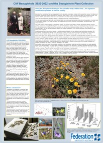
Poster, Michael McBain, Cliff Beauglehole Plant Collection
The Beauglehole Collection is held in the FedUni Science Herbarium (Mt Helen Y Building). Cliff Beauglehole (1920-2002) was an orchardist at Portland, Victoria. Over his lifetime he collected over 90,000 plant specimens as part of a comprehensice study of Victoria's plans, and wrote thirteen books under the title "The Distribution and Conservation of Vascular Plants in Victoria. Originally held by the Ballarat Field Naturalists Club, this set of herbarium specimens are from Cliff Beauglehole's collections in the Ballarat area. The club decided to hand over the plant collection to the University of Ballarat (now Federation University). They were freeze-dried to kill unwanted insects and are now house in a climate conrolled room, and available to students, staff and others for scientific study. Listing of specimens held in the Federation University Cliff Beauglehole Collection, and interpretation poster. herbarium, botany, botanical, text panel, cliff beauglehole, beauglehole collection, ballarat field naturalists club, plant specimens -
Federation University Historical Collection
Booklet, Ballarat School of Mines Botanical Gardens Conservation/Restoration Management Plan
A Conservation/Restoration Management Plan for the Ballarat School of Mines Botanical Gardens. The report includes a planting timeline of the plants included in the gardens from 1850. Historical plans and maps are detailed from 1857 up to the site assessment in 2008.Printed report stapled at top left corner.Lisa Palmer written at top right corner in pencil.smb, school of mines ballarat, ballarat school of mines, botanical gardens, smb botanical gardens, conservation, restoration, ballarat school of mines garden, von mueller garden, ferdinand von mueller, botany, living collections, horticulture, gardens -
 City of Moorabbin Historical Society (Operating the Box Cottage Museum)
A laminated , photocopy of the ‘Plan of Box Cottage c 1865 ‘, 1985
The original small, pioneer cottage was built in the late 1840s to early1850s, by an unknown pioneer. It was located on part of a 30 Acre allotment that was originally part of Dendy’s Special Survey granted in 1841. The doors and window sashes, (made of red deal joinery timber), as well as the brass locks and fittings, are from the original cottage, and were imported from England. The fire-place bricks are from the original cottage, and are sun-dried, (not kiln fired), and are hand-made. Convict marks can be seen on two bricks. There is a small display of external cladding shingles from the original pioneer cottage. These shingles were hand-split, and most likely made from locally collected timber The nails included in this display were used to fasten the shingles on the original cottage, and are also hand-made. The cottage was occupied by William Box and family from 1865 until 1914 when it was sold to William Reitman who resided there until 1950. The enamel nameplate, “Colonial”, on the wall of the cottage, was the name chosen for the original pioneer cottage by Mr William Reitman, when he purchased the property in around 1915, for 1200 Pounds approximately. In 1974 Mr Lewis, a timber specialist, found the dilapidated building on property he had recently purchased in Jasper Rd and suggested it be reconstructed and relocated. Moorabbin Council agreed and the cottage was rebuilt just about 250 metres from its original site. The cost of the rebuild was met by 'Victoria's 150th Committee, plus a small grant from the City of Moorabbin, and Mr Laurie Lewis donated much of the timber for the reconstruction. The re-constructed cottage plan has followed faithfully the original dimensions, and plan of the original pioneer cottage, and as many original items from that cottage’s long occupation have been incorporated. The photographs in Album 1 record the progress of the reconstruction from February 1984 to the First Public Open Day November 18th 1984Mrs H Deam and Mr A. Smith, CMHS members, photographed the progress of the 'Reconstruction' from February 1984 to November 1984. Although 'Box Cottage' is a re-construction, it is an unique museum that, being located in the midst of a modern community in Ormond Victoria, can educate and demonstrate many aspects of the early settler’s way of life in Victoria. As such, it is an invaluable resource for students and all kinds of visitors. A laminated , photocopy of the ‘Plan of Box Cottage c 1865 ‘ Hand drawn layout of 2 houses with shrubs, trees, plants, wells, gardens on the Box Cottage site c1930 as recalled by Stefanie Rietman Rennick. brighton, moorabbin, cottages, pioneers, ormond, colonial, mckinnon, dendy henry, box william, box elizabeth, reitman william, convicts lewis timber co. ltd., deam h, museums, box alonzo, smith a, -
 Bendigo Historical Society Inc.
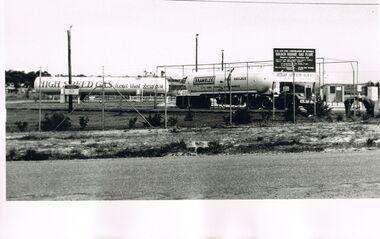
Photograph - CASTLEMAINE GAS COMPANY COLLECTION: PHOTO GOLDEN SQUARE DEPOT
L.P.G. Plan Gas and fuel Corporation of Victoria '' Golden Square Gas Plant'' Tank of ''High Speed Gas heat that obeys you '' at centre left side and a brambles baulk haulage truck at centre right.. Date Unknownorganisation, industry, gas and fuel -
 Bendigo Historical Society Inc.
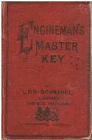
Document - BADHAM COLLECTION: ENGINEMAN’S MASTER'S KEY - BOOK BY L.F.R. SCHNABEL
Engineman’s Master's Key by L.F.R. Schnabel Licensed Inspector Melbourne, Victoria. Printed at the L.F.R Schnabel Engineering Institute, 443 Bourke St, Melbourne C 1903. Pans and specifications executed for Steam engines. Boilers and Power Plants, hard covered book worn.document, memo, railway, engineman’s master's key - book by l.f.r. schnabel - licensed inspector melbourne victoria, printed at the l.f.r schnabel engineering institute , 443 bourke st melbourne. plans and specifications executed for steam engines, boilers and power plants. -
Bendigo Historical Society Inc.
Document - BENDIGO AMALGAMATED GOLDFIELDS NO LIABILITY - PROSPECTUS OF BENDIGO AMALGAMATED GOLDFIELDS N. L
1. Printed Prospectus of Bendigo Amalgamated Goldfields No Liability dated 1917. The Company was being formed amongst other things to acquire 38 of the principal Mining Properties contiguous to one another and situated in the heart of the Bendigo Goldfield. Properties are listed. Itmes include List of Assets, Liabilities, Future of Company, a short report on the Central Area of the Bendigo Goldfield by E C Dyason, B. Sc., B M E, Yields from Bendigo Goldfields, Financial Results from Bendigo Mining, The Bendigo Goldfield-Resources of the 'Central Area' (Abridged) by V Pabst, Report on Plant and Machinery by Andrew Harkness, Summarised Report on the Properties within the'Central Area' Bendigo Goldfield, Schedule of Properties to be Acquired, Plan of Leases and a Form of Application. 2. Share Certificate ( photocopy of original ) : ' Flora McKell of Melbourne is a member of the above named Company ' and has forty shares paid up to ten shillings each. Signed Angus Mackay Director, W. Stanfield, Secretary. Dated 24th June 1921.document, gold, bendigo amalgamated goldfields n l, bendigo amalgamated goldfields no liability, prospectus of bendigo amalgamated goldfields no liability, l v lansell, h m leggo, w angliss, e c dyason, commonwealth bank of australia, ward & co, furner & brownhill, laurie & hodgetts, corrie & co, w stennard, h hawkins, clarke & co, f douglas jones, arthur phillips, j h craig, a capper moore, j g stanfield, norman picot, v pabst, h y north, walter weddell, lea butler birch, george h green, mccoll rankin & stanistreet, elden h kirkwood, geo j keogh