Showing 200 items matching "quartz hill"
-
 Bendigo Historical Society Inc.
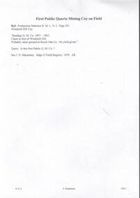
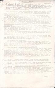
Document - WINDMILL HILL - FIRST PUBLIC QUARTZ MINING COY ON FIELD
... WINDMILL HILL - FIRST PUBLIC QUARTZ MINING COY ON FIELD... history. Document WINDMILL HILL - FIRST PUBLIC QUARTZ MINING COY ...First Public Quartz Mining Coy on Field. Ref: Production Statistics B. M. L. N. L. Page 201 Windmill Hill Coy. 'Bendigo Q. M. Co,1857 - 1863. Claim at foot of Windmill Hill. Probably same ground as Royal Oak Co. No yield given.' Query. - Is this first Public Q. M. Co.? See J. N. Macartney. Bdgo G'Field Registry 1870. Initialled AR. Document from Albert Richardson Collection of mining history.document, gold, windmill hill, windmill hill, first public quartz mining coy on field, production statistics b m l n l page 201, windmill hill coy, bendigo q m c 1857 - 1863, royal oak co, j n macartney bdgo g'field registry 1870 -
 Bendigo Historical Society Inc.
Memorabilia - GOLD NUGGET COLLECTION: THE GEM, 1906
The Gem The Poseidon Rush. Tarnagulla, Saturday. Article - The Albury Banner and Wodonga Express (NSW : 1871 - 1938)Friday 8 February 1907 - Page 43 The Poseidon Rush. Tarnagulla, Saturday. Several indicators and quartz leaders on the Woolshed Hill have received considerable attention during the last fortnight. In some claims the stone looks very promising, and nice tracings of gold have been obtained. Wragg Brothers struck it rich yesterday. At a depth of 12ft. on the bedrock they discovered a nugget specimen 206oz. in weight, which has been christened the 'Port Arthur. The party also had the good fortune to find two other specimens close, by, one weighing 23oz. 15dwt. and the other 24oz.These were named 'The Twins,' the Wragg Brothers bearing that distinction. In this claim about eight weeks ago the Gem (88oz.) was unearthed. THE POSEIDON RUSH. Article Illustrated - Leader (Melbourne, Vic. : 1862 - 1918, 1935)Saturday 29 December 1906 - Page 33 THE POSEIDON RUSH. It is only about five weeks since this rush was opened by John Porter, but since that time a marvellous change has taken place. The quietness of the bush has given place to a scene of wild excitement, and each week this is intensified by the discovery of large nuggets. When Smith, Rogers and Stephenson picked out their slug on election day, no one dreamed that larger ones were lying only a few feet away, but such was the fact. On Tuesday afternoon two immense slugs, one of which weighed 960 oz., and the other 373 oz., were found in adjoining claims within a few minutes of each other. The finding of these created a scene which it is difficult to describe. "I've got one, “was shouted from the claim of Bert Williamson and T. Stephenson, two men just entering into manhood. They were seen excitedly digging round a lump of gold, one of them with a double-ended pick, the point-of which he broke in his anxiety to unearth it. This slug is nine inches long by seven inches by 43 inches, and is very similar in appearance and size to the big nugget got previously in the adjoining claim. It has been cleaned and smelted, and has yielded 306 oz. of pure gold of the best sample. Before the excitement caused by the discovery of the last nugget had sub-sided, there was a shout from an adjoining claim. Sam Woodall, a Llanelly miner, felt his pick strike a hard yielding sub-stance, and, satisfied that he had struck a nugget, called the attention of his mates to the fact. He soon levered it out of the ground with his pick. Taking it up in his arms he staggered out of the claim with it, and in a minute or two was sur-rounded by hundreds of men who rushed from all over the field to view it, and to feel its weight. It was certainly a magnificent specimen, and the fortunate miners were congratulated on all sides. Its weight was guessed to be a hundredweight, and probably in its then dirty state it would nave turned the scales at that. In a few minutes the crowd was so dense that it was impossible to get a close inspection. The nugget was first taken to Newbridge under escort, then through Llanelly to Tarnagulla, where it was lodged in the Union Bank. It was found that the bank scales were not sufficiently large to weigh the mass. By tying a number of large weights together, and suspending them from a steel bar, a fairly accurate weight was obtained, and it just balanced 80 lb., or 960 oz. The nugget measures 16 in. x 10 in. x 5 in. The party was cheered as it drove up the main street here, and the sight of an armed escort was quite a novelty. The nugget was held aloft in a tin dish for inspection by the crowd. These nuggets were found in the shallow workings, and neither of them were a foot under the surface. The ground is a black loamy soil; there was no appearance of wash whatever, and no one knowing anything of alluvial mining would think of searching for gold in such a spot. All those who have claims on the hillside are breaking out all the dirt in a face from the surface to the reef, which is a mixture of lime and sunstone, and searching for nuggets. The ground is carefully pulverised so that nothing shall be missed. Some are puddling the whole of it, but it is hardly payable. Where the big nuggets are now being found, the ground has been pegged out and abandoned more than once since the rush started, and shares in the claims have been purchased for small amounts. Smith was given a third share in the claim where the first nugget was found for puddling the dirt big lump was discovered, by Woodall, Condron, Brooks and Eva, two of them sold a sixth share for £5 a few days ago to a man named Woods, who only worked a few days and sold out again for 50/. Some fancy prices are now being offered for shares in the claims in the vicinity. Woodall holds a third share, Condron and Brooks three-quarters of a share each, and Eva a sixth share. The largest nugget has been christened "The Poseidon." The names given to the other nuggets obtained previously are as follow: — Wragg Bros., 88 oz. nugget, "The Gem"; Smith and party's 378 oz. nugget, which was unearthed on election day, has been fittingly named "The Federal"; Jackson and Hughes 152 oz.specimen, "The Little. Beu"; Williamson and Stephenson's 373 oz. nugget is said to be called "The Christmas Box." A representative from the (Mines department has been at the bank during, the week taking models for the museums and schools of mines. )A replica of the "Gem" gold nugget that was discovered on 29.11.1906 on the Poseidon Lead at Tarnagulla at the depth of 9 feet. Found on the bedrock by the Wragge Bros. Weight 88 ozs. Value of $126,358 in 2016. (See additional Research.)mining, models, plaster model of victorian gold nugget -
 Bendigo Historical Society Inc.
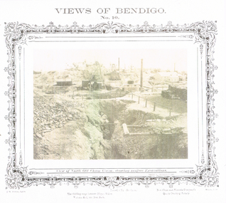
Photograph - LONG GULLY HISTORY GROUP COLLECTION: VIEWS OF BENDIGO NO 10
BHS CollectionSepia copy of a photograph titled Views of Bendigo No. 10. Photo has a printed decorated edge. Under the photo is View of North Old Chum Claim, showing surface Excavations. N J Caire was the Sandhurst photographer. Printed at the bottom is: The dividing range between Happy Valley, Victoria Hill and Iron Bark, Lansell's No 180 Claim and New Chum and Victoria Company's Quartz Crushing Battery, J W Forbes, Agend and another name beginning with a W. In the photo are three tall chimneys, poppet legs, buildings, stacks of wood, fences and in the foreground a large excavation with a heap of rubble beside it.bendigo, history, long gully history group, the long gully history group - views of bendigo no 10, north old chum claim, n j caire, j w forbes, lansell's no 180 claim, new chum and victoria company's quartz crushing battery -
 Bendigo Historical Society Inc.
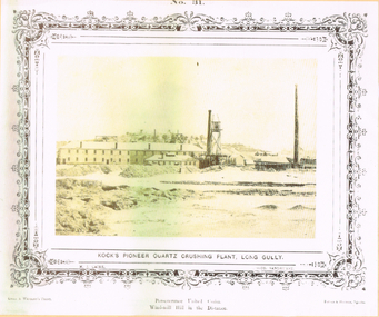
Photograph - LONG GULLY HISTORY GROUP COLLECTION: KOCK'S PIONEER QUARTZ CRUSHING PLANT LONG GULLY
The initial partnership in a quartz crushing plant between Henry Koch, Simon Albert and Charles Wallin was dissolved in 1860 with Koch becoming the sole owner. In 1866 the crushing plant consisted of a 50 hp engine and 48 stamping heads capable of crushing 600 tons of quartz per week. By 1902 there were 72 stamps and this was by far the largest crushing plant in the area, serving many quartz mines. Henry Koch (1800-1889) was a German sailor who signed off when his ship reached Melbourne in 1851. Having heard of the gold discovery he proceeded to Bendigo where he was initially employed in puddling in the Myers Flat area. He was soon employed and then made partner in a quartz crushing plant that he became sole owner of in 1860. He was also landlord at the British and American Hotel and the Silver Mines Hotel. HE also started the Perseverance United gold claim. He married Anna Maria Theresia Heinz in 1857. In 1872 he sold the crushing plant for 75,000 pounds and took his family back to Germany. He resumed his trade as a ship builder although he maintained many Bendigo mining interests.Yellow tone photo which has some green through it photo of Kock's Pioneer Quartz Crushing Plant, Long Gully. No 31 printed at the top. The photo has a decorative frame around it. It is a N. J. Caire Photo, Sandhurst and a Casey & Wenborn's Print. Forbes & Holmes, Agents. The photo has a long two storey building with chimneys and some smaller buildings and tall mine chimneys. Printed below is Perseverance United Claim and Windmill Hill in the distance. Paper is mounted on yellow card which is mounted on dark tan card and laminated.bendigo, history, long gully history group, the long gully history group - koch's pioneer quartz crushing plant - long gully, n j caire, casey & wenburn, forbes & holmes, perseverence united claim, windmill hill -
 Bendigo Historical Society Inc.
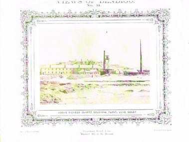
Photograph - LONG GULLY HISTORY GROUP COLLECTION: KOCK'S PIONEER QUARTZ CRUSHING PLANT LONG GULLY
BHS CollectionYellow tone photo of Kock's Pioneer Quartz Crushing Plant, Long Gully. Views of Bendigo No 31. Decorative border around the photo. Name printed under the photo. N J Caire Photo, Sandhurst. Casey & Wenburn's Print. Fu?? & Holmes?, Agents. Printed under the photo is - Perseverance United Claim. Wind-mill Hill in the Distance.bendigo, history, long gully history group, the long gully history group - kock's pioneer quartz crushing plant, long gully, n j caire, casey & wenburn's print, fu?? & holmes? agents -
 Bendigo Historical Society Inc.
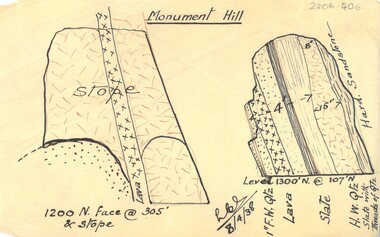
Document - MCCOLL, RANKIN AND STANISTREET COLLECTION: MONUMENT HILL PLAN
Plan of Monument Hill mine drawn in black ink on buff coloured tracing paper. Plan shows diagram of stope and describes rock profile; 1" F.W. quartz, lava, slate H.W. quartz and slate with threads of quartz. Hard sandstone on side of stope. Signed LCS (?) 8/4/38business, mining, monument hill consolidated company -
 Bendigo Historical Society Inc.
Document - RAE'S CRUSHING BATTERY - THE RICH VICTORIA HILL
Eleven pages including four pages of photocopied photos, They are:- Wm Rae's Crushing Works, The Victoria Quartz Mine, Looking North from Old Chum Hill to the Victoria Hill early 1870's, Victoria Hill from Rae's Open Cut. Notes begin at page 4, there are two page 6 and no page 7, otherwise same notes as 3573.1. Small note with 'Notes on Victoria Hill - incomplete. Notes prepared by Albert Richardson.document, gold, rae's crushing battery, rae's crushing battery, wm rae's crushing works, victoria quartz mine, view from old chum hill to the victoria hill, victoria hill from rae's open cut, ballerstedt, lansell's bit 180, dickers mining record 23/11/1861, j n macartney bendigo goldfields registry 1871, new chum syncline, cleopatra needle type chimney, victoria quartz coy, annals of bendigo, australian mining standard special edition 1/6/1899, bendigo advertiser, bendigo & vicinity 1895, h harkness & sons, new chum drainage scheme, eureka extd, new chum railway, pearl, inrush of water at victoria quartz mine, floyd's small 5 head crushing battery, great central victoria (midway), midway, midway no 2, midway north, ballerstedt's small 24 yard claim, the humboldt, wittscheibe, the adventure, bendigo mines ltd, luffsman & sterry's claim, round shaft, chinese joss house, fortuna -
 Bendigo Historical Society Inc.
Document - VICTORIA HILL - THE RICH VICTORIA HILL AND IT'S HISTORICAL ASSOCIATION
Two copies of document : nineteen handwritten pages of notes on 'The Rich Victoria Hill and Its Historical Association' Signed by A Richardson and dated 30 - 8 - 1971. and a typed copy of same. Notes include: Introduction, Hotels, Mines, Mining History and descriptions of features where the signposts are. Mines mentioned in the text are: North Old Chum. Ballerstedt's first open cut, Lansell's Big 180. 20 head stamper, Lansell's Cleopatra Needle, Victoria Quartz Mine. Cleopatra's Needle was a square sectioned brick chimney with this four sided pyramidal chimney top with four vents to allow the smoke to escape whatever the direction of the wind. It was demolished in the 1950's as it had a bend in it and it was considered unsafe. Lansell had two other mines with similar chimneys, the '222' in Chum Street and his 'Sandhurst' or 'Needle' mine near the Bendigo, Eaglehawk boundary. Notes prepared by Albert Richardson.mine, gold, victoria hill, victoria hill, the rich victoria hill and it's historical association, j. n. macartney, quartz miner's arms hotel, ironbark methodist church, greek orthodox church, john brown knitwear factory, little 180 mine, geo lansell, conrad heinz, british & american hotel, victoria reef gold mining coy, manchester arms hotel, housing commission homes, ironbark (victoria reef gold mines, hercules and energetic, midway, wittscheibe, gt central victoria, wm rae, mr & mrs conroy, wm rae jr, central nell gwynne, moorhead's shop, gill family, gold mines hotel, david chaplin sterry, pioneer, new chum and victoria, burrowes and sterry, new chum and victoria tribute, rotary club of bendigo south, big 180, victoria quartz mines, jeweller's shop, bendigo and district tourist association, north old chum mine, john wybrandt, ballerstedt's first open-cut, j c t christopher ballerstedt, ballerstedt's mine, bendigo cemetry, lansell's 'cleopatra nedle' type chimney, 222 mine, sandhurst or 'needle' mine, victoria quartz mine, victoria reef quartz company, mr e j dunn, eureka ext'd, new chum railway, pearl, bendigo advertiser 16 june 1910, victoria consols, shamrock, shenandoah, victoria quartz dams, rae's open cut, prospecting tunnels, floyd's small 5 head crushing battery, gt central victoria (midway) shaft, midway no 2, midway north, ballerstedt's small 24 yard claim, the humboldt, the tribute coy, advance, luffsman and sterry's claim, a round shaft, chinese joss house, lansell's fortuna, p m g repeater station, a richardson -
 Bendigo Historical Society Inc.
Document - VICTORIA HILL - KEY TO SIGN POSTS ON AREA MAP
Three page hand written carbon copy of Sign numbers at Victoria Hill. No 1 North Old Chum Shaft, No 2 Ballerstedt's First Open - Cut. Special Sign Post, No 2 C Rock Formations Pitching North, No 2 B Rich shallow shafts, No 2 A Quartz veins, No 4 A Concrete Dams, No 3 Engine Beds - Lansell's 'Big 180' Mine, No 3 B Lansell's 'Big 180' Shaft, No 4 Twenty Stampers Crushing Battery, No 3 C Foundations - 'Cleopatra Needle' type Chimney for Lansell's 'big 180' Mine, No 5 Victoria Quartz Mine, No 5 A Fou;ndations Victoria Quartz Poppet Legs, No 5 C Foundations Victoria Quartz Winding Plant, No 5 B Victoria Quartz Dams, No 6 Rae's Open - Cut, No 9 Quartz Once Roasted Here, No 12 Anticlinal Arch, No 15 primitive Tunnels, No 14 Beautifully Coloured Rock Formations, No 16 Adit, Graded Bedding, Oblique Fault, Spurry Quartz Veins, No 17 Prospecting Tunnels, No 18 Floyd's Small Crushing Battery, No 19 Gt Central Victoria (Midway) Shaft, No 20 Great Central Victoria (Midway) Engine Bed, No 21 ballerstedt's Small 24 Yard Claim, No 22 Humboldt Shaft, No 23 Wittscheibe's 'Jeweller's Shop', No 24 The 'Adventure' ground, Large Open - Cut, No 26 Luffsman and Sterry's Ground, NO 27 A Round Shaft, Notes prepared by Albert Richardson.mine, gold, victoria hill, victoria hill, victoria hill key to sign posts on area map, north old chum shaft, ballerstedt's first open cut, lansell's big 180 shaft, 'cleopatra needle' type chimney, victoria quartz mine, rae's open cut, prospecting tunnels, floyd's small crushing battery, gt central victoria (midway) shaft, ballerstedt's small 245 yard claim, humboldt shaft, wittscheibe's 'jeweller's shop', adventure, luffsman and sterry's ground, david sterry, sterry's 'gold mines' hotel, round shaft -
 Bendigo Historical Society Inc.
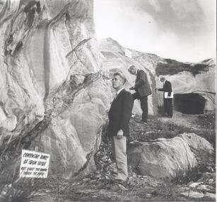
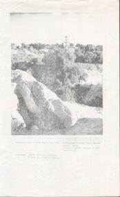
Photograph - VICTORIA HILL - PHOTOGRAPH WITH CONCENTRIC RINGS OF IRON OXIDE
Black and white photograph of three men dressed in suits looking at some rocks. The tall rock on the left has darker markings on it. In the background is a rectangular tunnel ? Opening. Sign at the foot of the rock reads: Concentric rings of iron oxide. Note quartz spur running throught the centre. A. E. Richardson written on the back. Some other indecipherable writing on the back.mine, gold, victoria hill, victoria hill, photograph with concentric rings of iron oxide, a e richardson -
 Bendigo Historical Society Inc.
Document - VICTORIA HILL - CONDENSED HISTORY OF VICTORIA HILL
Handwritten carbon copy of a short history of Victoria Hill. Date on top of page is 13/10/69. Notes mention claims and who bought them and the value of the gold. Notes prepared by Albert Richardson.mine, gold, victoria hill, victoria hill, condensed history of victoria hill, theodore ballerstedt, george lansell, touzeau and co., wm rae, bon accord, victoria quartz, wittscheibe's jeweller's shop, luffsman and sterry, adventure, advance, cinderella, j n macartney, bendigo goldfield registry, the backbone of sandhurst -
 Bendigo Historical Society Inc.
Document - VICTORIA HILL - VICTORIA HILL HISTORY
Hand written notes and typed copy of the history of Victoria Hill area. Some of the mines from South to North: North Old Chum, Lansell's 'Big 180', Ballerstedt's Open - Cut, 20 Head Battery Stampers, The Victoria Quartz, Rae's Open - Cut, which has some colourful geographical features, Central Victoria (also known as the 'Midway'), Wittshiebe's 'Jeweller's Shop', Boldt's 5 Head Crushing Battery (site only), Advance Shaft, Hercules & Energetic. Notes prepared by Albert Richardson.mine, gold, victoria hill, victoria hill, victoria hill history, north old chum, john wybrandt, lansell's 'bit 180', t ballerstedt, wittschiebe, fortuna villa, geo lansell, a h q survey regiment, ballerstedt's open cut, victoria quartz (victoria reef quartz), rae's open cut, wm rae, gt central victoria (midway), adventure, wittshiebe's 'jeweller's shop', boldt's 5 head crushing battery, advance, cinderella, hercules & energetic, john brown knitwear factory, a richardson -
 Bendigo Historical Society Inc.
Document - VICTORIA HILL - THE BENDIGO DIGGINGS, PRELIMINARY DRAFT FOR BROCHURE
BHS CollectionNine typed pages of notes on a preliminary draft for a brochure on the Bendigo Diggings. First part is the objective which is to preserve the mining history and to have exhibits in the places they were used, e.g. quartz mining machinery exhibited in a quartz mining area, not on an alluvial field. Part B is historical notes on the area. Part C is the Site - Victoria Hill area. Part D is Stage One which consists of carpark area, technological museum, restaurant, mineral haulage line, picnic ground, earthworks and planting over the area. Part E is Stage Two which will consist of the open-air exhibits, in the area surrounded by the mineral haulage line, and the Central Nell Gwynne mine on the west side of the site. Part F is Stage Three which will consist of the winery, the steam tram track, the lake, the wildlife sanctuary and various buildings associated with gold mining. Part G is Costing with the prices to be filled in. Parts H and I are the Appeal and the Committee. Details to be filled in. Notes prepared by Albert Richardson.mining, marketing, victoria hill, victoria hill, the bendigo diggings - preliminary draft for brochure, aust national travel association, tullamarine jetport, emu bottom homestead, kyneton historical museum, chinese joss house, eaglehawk museum, whipstick scrub, cairn curran reservoir, castelmaine historical museum and market hall, national trust, ballarat hiatorical park, echuca's hopwood gardens, swan hill folk museum, gibson's mount alexander no 2 squatting run, captain brown, chief commissioner wright, hustler's reef, thomas hustler, mining board, drainage of reefs act 1862, first world war, bendigo amalgamated goldfields, second world war, sandhurst, w c vahland, battery trams, horse trams, steam trams, electric trams, central nell gwynne mine, theodore ballerstadt, george lansell, new chum hill, ballerstadt's open cut, 180 mine, new chum syncline battery, william rae, victoria quartz, wittscheibe's 'jeweller's shop', luffsman and sterry, gold mines hotel, adventure, bendigo and district tourist association, bendigo city council, bendigo branch of the royal historical society of victoria, professor brian lewis, school of architecture and building at the university of melbourne, taylor horsfield, lord robert cecil, south australian gold commissioner -
 Bendigo Historical Society Inc.
Document - VICTORIA HILL - MINES SITUATED ON VICTORIA HILL
Three pages of typed notes on creamy paper. Notes mention the mines on Victoria Hill and gives some information about them such as depth, ounces of gold extracted and who owned them. Mines mentioned are: The North Old Chum, Lansell's Big 180, Ballerstedt's Open-Cut, Little 180 Crushing Battery, the Victoria Quartz, Rae's Open-Cut, Great Central Victoria, Wittshiebe's 'Jeweller's Shop', Boldt's 5 Head Crushing Battery, Northern Slope and the Advance Shaft. Written in pencil at the top: Copy of material sent to Herald Reporter by R. Aulsbrook 30/7/68. Copied from my material and initialled AR. Notes prepared by Albert Richardson.mine, gold, victoria hill, victoria hill, mines situated on victoria hill, john wybrandt, wittscheibe, t ballerstedt, fortuna villa, george lansell, a h q survey regiment, ballerstedt's open-cut, little 180 crushing battery, little 180 mine, new chum syncline, victoria quartz (victoria reef quartz), rae's open-cut, william rae, great central victoria (midway), adventurer, wittshiebe's 'jeweller's shop', boldt's 5 head crushing battery, northern slope, the advance shaft, cinderella, hercules and energetic, john brown knitwear factory, r aulsbrook, the herald -
 Bendigo Historical Society Inc.
Document - VICTORIA HILL - SPECIAL FEATURES
Four hand written pages and typed copy, titled The Victoria Hill - Special Features. Notes mention the Victoria Hill, the deepest workings on the field,the first mine on the field to 2,000 and 3,000 feet in depth, Ballerstedt's Open-Cut, Rae;s Open-Cut, Wittscheibe's Jeweller's Shop, the Adventure, the richest cross-section of the whole of the Bendigo Goldfield, the first mine to pay dividends from ore mined below 1,000 feet to 1,500 feet from the surface, the tallest poppet legs on the field, Lazarus Mine, Barnet Lazarus, Mt Alvernia Hospital, Central Red White & Blue. Notes prepared by Albert Richardson.document, gold, victoria hill, victoria hill, victoria hill - special features, john neill macartney, the argus, the australasian, bendigo goldfields registry, victoria reef quartz mine, the deepest workings on the field, the first mine on the field to reach 2, 000 and 3, 000 feet in depth, lansell's 'big 180' mine, hot water, george lansell, theodore ballerstedt, fortuna, ballerstedt's open-cut, rae's open-cut, wittscheibe's jeweller's shop, adventure, advance, cinderella, the private pioneer coy, new chum & victoria mine, a h q survey regiment, tallest poppet legs, lazarus mine, barnet lazarus, mt alvernia hospital, central redwhite and blue, hudson's, burrowes & sterry, b c v 8 television station, swan hill's channel 11 -
 Bendigo Historical Society Inc.
Document - VICTORIA HILL - LETTER TO ALBERT FROM DENNIS O'HOY
Typed letter to Albert from Dennis O'Hoy, dated 1st May, 1971. The letter outlines the activities of Jack Cohn, Clark Jeffery, Harry Biggs, Jim Sullivan and Dennis O'Hoy for the day. They went to Quarry Hill and looked at two tunnels, went ot the North Deborah, the Hill and the Log Gaol. Notes prepared by Albert Richardson.document, memo, victoria hill, victoria hill, victoria hill - letter to albert from dennis o'hoy, jack cohn, clark jeffery, harry biggs, jim sullivan, dennis o'hoy, addits at quarry hill, north deborah, central deborah, victoria quartz, log gaol -
 Bendigo Historical Society Inc.
Document - VICTORIA HILL - LETTER TO MR WODETZKI FROM A. RICHARDSON
Handwritten carbon copy of a letter from A Richardson to Mr Wodetzki and a few suggested spots for marking. He also mentions their geologist, Mr Eric Wilkinson may go over the area to determine what should be marked in regard to rock formations, etc. Albert Richardson collection.document, memo, victoria hill, victoria hill, letter to mr wodetzki from a richardson, mines dept, mr eric wilkinson, north old chum mine, ballerstedt's first open cut, lansell's big 180, ballerstedt's second open cut, ballerstedt jun'r, the crushing battery, the victoria quartz, rae's open cut, large cross spur or quartz vein, whip shaft, e j dunn -
 Bendigo Historical Society Inc.
Document - VICTORIA HILL - FURTHER SIGNS, VICTORIA HILL
... of further signs for Victoria Hill. Signs include Quartz Veins...DOCUMENT Memo victoria hill Victoria Hill Further Signs ...Handwritten carbon copy, and later typed copy, of a list of further signs for Victoria Hill. Signs include Quartz Veins, Prospecting Shaft, 1929, Concrete Dam, Anticlinal Arch New Chum Line, Engine Beds for Gt Central Victoria (Midway Mine), Prospecting Tunnels, Primitive Tunnel. Notes at the end: Given to Geo & Max Ellis on 31/3/1971 and Prospecting tunnels driven from small Open Cut in 1860's. Notes prepared by Albert Richardson.document, memo, victoria hill, victoria hill, further signs victoria hill, new chum line, gt central victoria (midway mine), victoria quartz, davis, geo ellis, max ellis -
 Bendigo Historical Society Inc.
Document - VICTORIA HILL - ADDITIONAL SIGNS IN & AROUND RAE'S OPEN-CUT
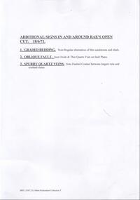
Carbon copy and typed notes for signs at Victoria Hill. Notes read: Additional Signs In and Around Rae's Open-Cut 18/6/71. (1) Graded Bedding - Note regular alternation of thin sandstones and shale. (2) Oblique Fault - Iron Oxide & thin quartz vein on fault plane. (3) Spurry Quartz Veins - note faulted contact between largest vein and crushed slates. Notes prepared by Albert Richardson.document, victoria hill, victoria hill - additional signs in and around rae's open-cut, graded bedding, oblique fault, spurry quartz veins -
 Bendigo Historical Society Inc.
Photograph - VICTORIA HILL - VICTORIA HILL FROM RAE'S OPEN CUT
Photocopied photo of Victoria Hill from Rae's Open Cut. In the background are the Poppet legs of the Central Nell Gwynne Mine. On the left background is the Victoria Quartz Mullock. In the foreground are rocks and trees. Photo courtesy of Robert Wallace Studios, 6 Ruth St, Golden Square. Albert Richardson collection.photo, victoria hill, victoria hill from rae's open cut, central nell gwynne, victoria quartz, robert wallace studios -
 Bendigo Historical Society Inc.
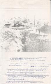
Photograph - VICTORIA HILL - LOOKING NORTH FROM OLD CHUM HILL TO THE VICTORIA HILL
Two copies of photocopied photo of an open cut mine which is straddled by Marong Road. In the background is The North Old Chum Mine, behind it is Lansell's Rich '180' Mine and in the distance is Ballerstedt's Rich Open Cut and the Victoria Quartz Mine. Notes prepared by Albert Richardson.photo, victoria hill, looking north from old chum hill to the victoria hill, a richardson, north old chum mine, lansell's rich '180' mine, victoria quartz mine, gold mines hotel -
 Bendigo Historical Society Inc.
Document - VICTORIA HILL - NOTES ON VICTORIA HILL (SIGNS)
Twelve handwritten copied pages (a & b) of notes with typed copy of same, regarding the signs for Victoria Hill. Signs indicate the feature and a description including Prospecting Shafts, dams, engine beds, Lansell's Big 180 Shaft, stampers, Victoria Quartz Mine, Victoria Quartz Dams, Rae's Open Cut, Anticlinal Arch, small primitive tunnels, Engine-bed for Great Central Victoria known as 'Midway' mine, prospecting tunnels, floyd's small 5 Head Crushing Battery, Ballerstedt's Small 24 Yard Claim, The Humboldt 1856 to 1861, Luffsman and Sterry's Claim, and A Round Shaft.document, memo, victoria hill, victoria hill, notes on victoria hill (signs), lansell's big 180, ballerstedt senior, george lansell, victoria quartz mine, victoria reef quartz coy, wm rae, a roberts & sons, mr e j dunn, new chum drainage scheme, eureka extended, new chum railway, pearl, bendigo advertiser, inrush of water at the victoria quartz, victoria consols, shamrock, shenandoah, victoria quartz dams, rae's open cut. prospecting tunnel, floyd's small 5 head crushing battery, great central victoria (midway), midway no 2, midway north, ballerstedt's small 24 yard claim, the humboldt, wittscheibe, the adventure, advance, george lansell, luffsman & sterry's claim, david sterry, gold mines hotel, city of sandhurst, lansell's fortuna, a richardson -
 Bendigo Historical Society Inc.
Document - VICTORIA HILL - NOTES ON SIGNS FOR VICTORIA HILL
Three page typed copy of notes for signs on Victoria Hill. Mentions items to be seen at Victoria Hill. Sign posts listed are for: Ballerstedt's First open Cut, Quartz Veins (Spurs), Prospecting Shafts 1929, Engine beds for Lansell's big 180 Mine, 20 Head Crushing Battery Stampers, concrete dam, Victoria Quartz Mine, Foundations of steel poppet legs of the Victoria Quartz Mine, Victoria Quartz Dams, Rae's Open Cut, Site where the quartz was roasted, Anticlinal Arch , coloured rock formations, primitive tunnels, Adit, Engine bed for Great Central Victoria, Prospecting Tunnels, Great Central Victoria (Midway). Notes prepared by Albert Richardson.document, victoria hill, notes on signs for victoria hill, gold mines hotel, ballerstedt's first open cut, quartz veins (spurs), prospecting shafts 1929, engine beds for lansell's big 180 mine, 20 head crushing battery stampers, concrete dam, victoria quartz mine, foundations of steel poppet legs of the victoria quartz mine, victoria quartz dams, rae's open cut, site where the quartz was roasted, anticlinal arch , coloured rock formations, primitive tunnels, adit, engine bed for great central victoria, prospecting tunnels, great central victoria (midway), a richardson -
 Bendigo Historical Society Inc.
Document - VICTORIA HILL - THE CENTRAL DEBORAH AND THE VICTORIA HILL
Handwritten carbon copy and typed copy of a letter to be published in the paper, dated 16/4 1971. Letter is from A. Richardson thanking the Bendigo Trust, various Service Clubs, The Bendigo Branch of the Royal Historical Society, the City Council and its employees and the Lady members of the Historical Society for their great team effort in completing the first stage of the restoration of the Central Deborah Gold Mine in time for visitors during the Easter Holidays. Letter prepared by Albert Richardson.document, victoria hill, the central deborah and the victoria hill, bendigo trust, the bendigo branch of the royal historical society, bendigo city council, central deborah gold mine, the rotary club of bendigo south, bendigo and district tourist association, bendigo diggings project, john brown knitwear factory, gold mines hotel, big 180 mine, victoria quartz, city of sandhurst, bendigo advertiser, a richardson, mr cyril nichelson -
 Bendigo Historical Society Inc.
Document - VICTORIA HILL - GUIDE TO VICTORIA HILL 1854 - 1949
Handwritten (3587.35a) and carbon copy (3587.35b) of notes on Victoria Hill and Guide to Victoria Hill. First page has a brief history and also mentions various clubs and the City Council who helped clean the rubbish from the Hill. Signed by Albert Richardson. Dated 5/4/1971.document, gold, victoria hill, victoria hill, guide to victoria hill 1854 - 1949, gold mines hotel, rotary club of bendigo south, city council, bendigo and district tourist association, lansell's 180, victoria quartz, central deborah mine, ballerstedt's first open cut, theodore ballerstedt, little 180 co, thompson's of castlemaine, rae's open cut, roberts & son, quartz roasting, e j dunn, great central victoria (midway), a richardson -
 Bendigo Historical Society Inc.
Document - VICTORIA HILL - ABRIDGED SIGNS FOR VICTORIA HILL
Handwritten carbon copy of notes with typed copy of same, for signs on Victoria Hill. Signs mentioned are: Ballerstedt's First Open Cut,20 Head Crushing Battery, Victoria Quartz Mine, Victoria Quartz Foundations of Steel Poppet Legs, Coloured rock formations, Primitive tunnels, Adit, Engine Beds Lansell's Big 180 Mine, Anticlinal Arch, Coloured rock formations marking and patterns. Notes prepared by Albert Richardson.document, gold, victoria hill, victoria hill, abridged signs for victoria hill, ballerstedt's first open cut, 20 head crushing battery, victoria quartz mine, victoria quartz foundations of steel poppet legs, coloured rock formations, primitive tunnels, adit, engine beds lansell's big 180 mine, anticlinal arch, coloured rock formations marking and patterns -
 Bendigo Historical Society Inc.
Document - VICTORIA HILL - SUGGESTED WORDING OF SIGNS FOR VICTORIA HILL
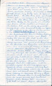
Handwritten carbon copy of suggested wording for signs at Victoria Hill. Mentions mines and open cuts and amounts of gold, and geological features. Notes prepared by Albert Richardson.document, gold, victoria hill, victoria hill, suggested wording of signs for victoria hill, the north old chum mine, ballerstedt's first open cut, lansell's big 180, crushing battery, the victoria quartz, coloured rock formations, great central victoria, wittscheibe's 'jewellers shop', luffsman & sterry's claim, the adventure -
 Bendigo Historical Society Inc.
Document - VICTORIA HILL - KEY TO SIGN POSTS ON AREA MAP
Photocopied handwritten notes with typed copy of same, on Sign Posts on Victoria Hill.. Sign posts were for mines and their associated equipment and geological formations. Initialled AR. Notes prepared by Albert Richardson.document, victoria hill, key to sign posts on area map, north old chum shaft, ballerstedt's first open cut, rock formatins, lansell's big 180, 20 stampers crushing battery, foundations 'cleopatra needle' type chimney, victoria quartz mine, rae's open cut, quartz roasting, anticlinal arch, primitive tunnels, coloured rock formations, adit, oblique fault, spurry quartz veins, prospecting tunnels, floyd's small crushing battery, gt central victoria (midway) shaft -
 Bendigo Historical Society Inc.
Document - VICTORIA HILL - CLASSIFICATION REQUEST
Handwritten, 3 page carbon copy of a classification request for victoria Hill. Notes give locality, housing program in the area, immediate surrounds of the area, prominent citizens, buildings, mines, geographical formations and gold production. Notes prepared by Albert Richardson.mining, parish map, victoria hill, classification request for victoria hill, gold mines hotel, john brown knitwear factory, lansell's fortuna villa, army survey corp, housing commission, hercules, energetic, ironbark, manchester arms hotel, bendigo goldfield, old miners homes, george lansell, sir george lansell, bendigo advertiser, theodore ballerstedt junior, mr c t c johann ballerstedt, mr wm rae, david sterry, adventure, wittscheibe's 'jewellers shop', luffsman & sterry's rich claim, ballerstedt open cut and mine, lansells 180, victoria quartz, rotary club of bendigo south, bendigo cemetry -
 Bendigo Historical Society Inc.
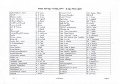
Document - MINING REPORTS - LIST OF LEGAL MANAGERS
Handwritten list by Albert Richardson, with typed copy of same, of some Bendigo Mines and their Legal Managers, as at September 30th, 1906. Document is part of the Albert Richardson Collection. document, gold, miner's right, mining reports, list of legal managers, j h craig, j h mccoll, g a petrie, h birch, b crofts, h y north, h kirkwood, s h mcgowan, g j keogh, c moore, w g blackham, w b walker, j humming, g h green, catherine reef united, carlisle, clarence united, central ellesmere, collman & tacchi, confidence extended, cornish united, daly & westons, don, ellenborough, extended southdevonshire, eureka, fortuna hustlers, fosterville, garden gully united, g g consolidated, garibaldi, great southern, great northern, great extended hustlers, great columbian, great central victoria, golden age, golden pyke, goldfields north, goldfields consolidated, hercules & energetic, hustlers reef, hustlers reef no 1, hustler's royal reserve, ironbark, johnson's reef, johnsons extended, koch's pioneer, lancashire, lazarus new chum, lady barkly, lightning hill, mcduff amalgamated, morning star, new chum consolidated, new chum railway, new chum & victoria, new red white & blue consolidated, new hopeful, new st mungo, new argus, new moon, new prince of wales, north lady brassey, new victoria catherine, new chum goldfields north new moon, north argus, north johnsons, pearl, princess dagmar, phoenix, railway prince of wales, shamrock, st mungo, sadowa, sea, stewart's united specimen's hill, south st mungo, south new moon, south devonshire, suffolk united, south prince of wales, spring gully junction, true blue, thomas united, united devonshire, unity, united hustlers & redan, united ulster, victoria consols, victoria reef quartz, victory and pandora, virginia, victoria proprietory, williams united