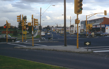
Showing 1073 items matching "south melbourne city"
-
 Warrnambool and District Historical Society Inc.
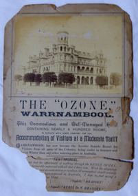
Poster - Warrnambool Ozone Hotel Poster, Circa 1895
The Ozone Coffee Palace was built in 1890-1891. It was designed by Mr J McLeod. It was grand in design and decoration. The term Coffee Palace was used to describe temperance hotels which were built during the 1880’s -1890’s. They typically were multi-purpose and had a large number of rooms for ballrooms and leisure activities. Coffee palaces were aimed at families in coastal areas and inner city locations. Examples of some are The Windsor Hotel Melbourne, Ozone, Queenscliff and Kilbreda Convent in Mentone. The bottom part of the advertisement is a testimonial written by Brassey and Sybil De V Brassey, Lord Brassey being Governor of Victoria around 1895. Their visit to Warrnambool and their stay at the Ozone sparked a much needed interest in the Ozone. In 1896 the price to stay at the Ozone was two pounds two shillings and it remain in business for several years but in 1910 it closed after losing money for many years. It remained closed until it was bought by Mr Howard Lawson in 1920. It continued to struggle financially. It was burnt down in February 1929. When the Ozone was built in1891 it was the largest building in Warrnambool. It occupied a prominent position on the corner of Koroit and Kepler Streets. The grand architectural style in which it was built, was used for a number of similar buildings throughout the state. The fire which destroyed the building was one of the largest in the town.Large photograph glued to the top of the card with text in various styles underneath. Photo is sepia and card is cream. The bottom part of the piece has broken away. Jordan in bottom LH corner of photograph. “L.N. Moore 2 Landcox St Nth Brighton” written in pencil on back. warrnambool, ozone coffee palace warrnambool, mansions hotel, hotel warrnambool, ozone fire 1929 -
 Orbost & District Historical Society
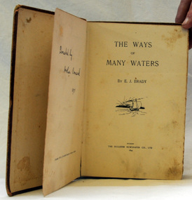
book, The Ways of Many Waters, 1899
This book of poetry by E. J. Brady was originally published by the Bulletin Newspaper Company (Sydney) in 1899,Later it was reprinted by Thomas C. Lothian (Melbourne) in 1909, and by the Standard Publishing Company (Melbourne) in 1913.] E. J. Brady was an Australian poet. He was born at Carcoar, New South Wales, and was educated both in the United States and Sydney. He worked as a wharf clerk, a farmer, and journalist, and edited both rural and city newspapers This book is culturally important as Edwin James Brady represented the Bulletin school of the 1890s. The Bulletin was very popular with rural bush workers and selectors and became known as ‘the bushman’s bible’. It encouraged contributions of poetry, short stories and cartoons from its readerswho included miners, shearers and timber-workers from all over Australia. Some of this content was high quality and many of Australia’s important writers had their start with The Bulletin which became know as the ‘Bulletin School’ of literature.A small 155 pp fabric covered brown book with a very faded picture of a boat sailing toward a sunset on the front cover.poetry literature brady-edwin-james the-ways-of-the-waters -
 Ringwood and District Historical Society
Card - Voting, Authorised by Ray Bradbury, Poster - Vote for James McCubbin - City of Ringwood council elections 1972, 1972
Large card/poster promoting the election of James C.B. McCubbin JP to the South Ward, City of Ringwood - Election Saturday 26th August, 1972. Photo image 17x12 is included in the notice. +Additional Keywords: McCubbin, James C.B.Text - City of Ringwood Annual Elections - South Ward. Saturday 26th August, 1972. Voting times 8am to 8pm. Vote for James C.B. McCubbin JP -1- and "Vote Mac Back - The Man on Your Side". -
 Learmonth and District Historical Society Inc.
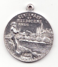
Medal - Centenary of Victoria, Centenary of Melbourne 1935
White metal medal issued to commemorate Melbourne's centenary 1934-35. This medal was given out to Victorian school children; 325,600 white metal medals were struck. There were also a few VIP pieces in other metals, including two in gold. The medal references Portland, the location of Victoria's first settlement. The Henty brothers, entrepreneur farmers and whalers, established the state's first permanent European settlement in Portland in 1834. Melbourne was established the following year by a party of settlers led by John Batman. In 1934, as Melbourne planned to celebrate the centenary of European settlement, it seemed to some that there was little to celebrate. The financial strains of the depression, unemployment and the scandal of the city's slums all undercut claims of unbridled progress. Perhaps because of such troubles, the organisers of the centenary celebrations tried doubly hard to be positive. The themes of the celebrations were conservative, reflecting the desire of some Melburnians for security in troubled times. The widely promoted image of the 'Garden City' and 'Queen City of the South' emphasised the idea of Melbourne as a very British city. A visit by the Duke of Gloucester, son of George V, the ageing king, provided a reassuring strengthening of Melbourne's imperial connections. The presented view of Melbourne's history stressed the 'myth of the pioneer', embodied in the person of John Batman. Elevated to heroic status, he was reinvented as a courageous pioneer whose life exemplified the rewards of self-improvement. Such a portrayal ignored Batman's dubious 'treaty' with local Aborigines and the less savoury details of his personal life. Melbourne's indigenous people were excluded from this triumphant view of Melbourne's past. The centenary celebrations now seem dated, but the image of Melbourne as a conservative city largely influenced by Britain has been more enduring.Details the settlement of Portland, Melbourne and Victoria, 1834 - 1935Double sided round white metal medal, featuring on front face, the bay of Portland showing a ship in the harbour. On the reverse side of the medal is John Bateman overlooking the city of Melbourne and the Yarra river.The front is inscribed, "CENTENARY OF VICTORIA" 1934, across the top, bottom right has the words "PORTLAND 1834". Reverse side shows "CENTENARY OF MELBOURNE 1935", and the date 1835 at the bottom. melbourne, medal, portland, centenary of victoria 1935 -
 Flagstaff Hill Maritime Museum and Village
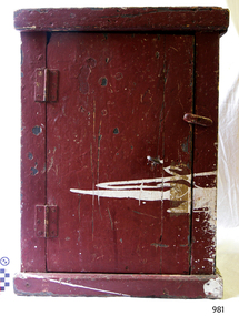
Furniture - Cupboard, Possibly 1920, when the City of Rayville was built
The biscuit locker came from the vessel the "City of Rayville", an American motor-driven freighter constructed in 1920. The ship was the second victim within 24 hours of an extensive minefield laid by German raiders in October 1940, during World War Two and the first American ship to be sunk in world war II. She was under the command of Captain Cronin and bound from Adelaide via Melbourne to New York, carrying a cargo of 1500 tons of lead from Port Pirie along with a cargo of wool and copper from Adelaide, when she struck a mine in the Bass Strait, six miles south of Cape Otway at 7:45 pm on 8th November 1940. The explosion was heard on shore at Apollo Bay; the force of it tore out the foremast and the ship sank within 25 minutes. There was a crew of 38 and all but one survived. A rescue crew of fishermen from Apollo Bay left shore in the dark and picked up the survivors from the dangerous sea taking them back to safety. The US Secretary of State Cordell Hull at the time wrote individual letters of thanks to all the rescuers involved. The biscuit locker is of historical and marine archaeological significance because of its association with the wreck of the City of Rayville. The vessel is listed on the Victorian Heritage Register No VHR S126. Additional significance is that the ship was the first American vessel sunk in the second world war and is still socially significant to the descendants of the City of Rayville crew and the Apollo bay fishermen who took part in the rescue.The external surfaces of the cupboard and the inside of the door are painted brown. The interior is painted blue the door has 2 metal hinges attached on the outside, each with 6 single-slotted screws and a wooden rotating door latch attached to the side of the door. There is a round eyelet on the door near the latch, the cupboard sides are each made from wood joined vertically and sit within a slightly wider, flat base and top. The frame of the cupboard is split with the paint on the outside of the cupboard scratched and chipped revealing a darker paint underneath. There is also a rough slash of white paint from the side of the cupboard going to about the Centre of the door. “PI/298” is hand written in black pen, paint or ink on the inside panel of the door in neat letters. "MS CITY OF RAYVILLE" stamped on back of cupboard in black paintcity of rayville, cupboard, locker, biscuit locker, 1940, world war ii, wwii, cape otway, german mines, american ship, flagstaff hill, warrnambool, flagstaff-hill, flagstaff-hill-maritime-museum, maritime-museum, shipwreck-coast, flagstaff-hill-maritime-village, rayvill -
 Flagstaff Hill Maritime Museum and Village
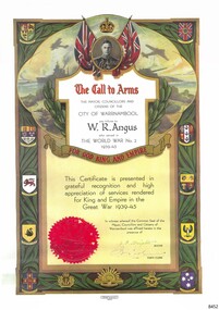
Certificate - Call to Arms, Osboldstone & Co. Pty. Ltd, W.R. Angus, ca. 1945
This copy of the Certificate of Call to Arms was presented to Dr William Roy Angus at the completion of World War II by the May, Councillors and Citizens of Warrnambool in appreciation for his service. It is now part of Flagstaff Hill’s comprehensive W.R. Angus Collection, donated by the family of Dr W R Angus, 1901-1970, surgeon and oculist. During World War II between 1942-45, Dr Angus served with the Australian Department of Defence as a Surgeon Captain in Ballarat, Victoria, and in Bonegilla, N.S.W., completing his service just before the end of the war due to suffering from a heart attack. The Certificate is headed by a crown above the portrait of King George VI, the reigning British monarch at the time of WWII and afterwards. King George was King of the United Kingdom and the Dominions of the British Commonwealth, which is illustrated by the emblems of the Commonwealth countries and of the states of Australia. It also has symbols for the three Australian Military Forces; Navy, Army and Air Vorce. The Certificate also carries the Common Seal of the Mayor, Councillors and Citizens of the City of Warrnambool, and the signatures of the Mayor and Town Clerk. The W.R. Angus Collection: - The W.R. Angus Collection includes historical medical equipment, surgical instruments and material belonging to Dr Edward Ryan and Dr Thomas Francis Ryan, (both of Nhill, Victoria) and Dr Angus’ own belongings. The Collection’s history spans the medical practices of the two Doctors Ryan, from 1885-1926 plus that of Dr Angus, up until 1969. It includes historical medical and surgical equipment and instruments from the doctors Edward and Thomas Ryan of Nhill, Victoria. Dr Angus married Gladys in 1927 at Ballarat, the nearest big city to Nhill where he began as a Medical Assistant. He was also Acting House surgeon at the Nhill hospital where their two daughters were born. During World War II He served as a Military Doctor in the Australian Defence Force. Dr Angus and his family moved to Warrnambool in 1939, where Dr Angus operated his own medical practice. He later added the part-time Port Medical Officer responsibility and was the last person appointed to that position. Both Dr Angus and his wife were very involved in the local community, including the planning stages of the new Flagstaff Hill and the layout of the gardens there. Dr Angus passed away in March 1970.This is an example of objects used by or issued to Doctor Angus during and after his military service as Surgeon Captain in Australia during World War II. The W.R. Angus Collection is significant for still being located at the site it is connected with, Doctor Angus being the last Port Medical Officer in Warrnambool. The Collection includes historical medical objects that date back to the late 1800s.Call to Arms; certificate of service awarded as a tribute to W. R. Angus by the Mayor, Councillors and Citizens of the City of Warrnambool and sealed with Common Seal and the signatures of the Mayor and the Town Clerk. The top of the certificate has a portrait of King George VI below a crown emblem. The border has logos for countries of the British Commonwealth - Canada, South Africa, Inda and New Zealand - and the Australian States of Queensland, South Australia, Victoria, West Australia and Tasmania. The bottom has the badges of the Royal Australian Navy, the Australian Commonwealth Military Forces and the Royal Australian Air Force. The Certificate was printed by Osboldstone & Co. of Melbourne, with the registered serial number 55319. This copy of the original certificate is part of the W. R. Angus Collection.Printed; "The Mayor, Councillors and citizens of the City of Warrnambool pay tribute to W.R. Angus who served in The World War No. 2 1939-45, for God, King and Empire" "This Certificate is presented in grateful recognition and high appreciation of services rendered for King and Empire in the Great War 1939-45." "In witness whereof, the Common Seal of the Mayor, Councillors and Citizens of Warrnambool was affixed hereto in the presence of " (Signatures of "J.F. Knights" [Mayor] "H.J. Worland" [Town Clerk]) Printed under the certificate: "Osboldstone & Co. Pty. Ltd. Printers, Melbourne" and "55319"flagstaff hill, warrnambool, maritime village, maritime museum, shipwreck coast, great ocean road, flagstaff hill maritime museum and village, dr w r angus, dr ryan, warrnambool base hospital, nhill base hospital, mira hospital, flying doctor, w.r. angus collection, australian department of defence, australian army, world war ii, wwii, surgeon captain, ballarat, bonegilla, certificate, call to arms, warrnambool mayor, j.f. knights, warrnambool town clerk, h.j. worland", city of warrnambool, world war no. 2', 1939-45, great war 1939-45, common seal of city of warrnambool, osboldstone & co. pty ltd., 55319, king george vi, british commonwealth, canada, south aftrica, india, new zealand, australian commonwealth military forces -
 Marysville & District Historical Society
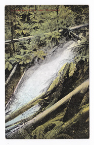
Postcard (item) - Colour tinted postcard, Nicholas John Caire, Cumberland Falls near Marysville, 1858-1918
One of a series of postcards of photographs taken by socialite photographer Nicholas John Caire. N.J. Caire had a great love for the area and in the late 1800's took many photographs of Marysville and its surrounds.One of a series of postcards of photographs taken by socialite photographer Nicholas John Caire. N.J. Caire had a great love for the area in and surrounding Marysville and in the late 1800's took many photographs of Marysville and its surrounds. N.J. Caire was born in 1837 in Guernsey. He arrived in Adelaide about 1860 along with his parents who encouraged his early interest in photography. He opened a studio in Adelaide in 1867 after traveling extensively throughout the Gippsland taking photographs. After marrying in 1870 he moved to Talbot in Victoria until 1876 when he opened a studio in the Royal Arcade in Melbourne. After 1885 N.J. Caire gave up his city work and made his home in South Yarra and devoted the rest of his life to outdoor photography, specializing in the bush, the gullies and the mountains of south-eastern Victoria. POST CARD Printed in Australia This space may be used for Correspondence/ within the Commonwealth without/ extra postage THIS SPACE FOR NAME AND/ ADDRESS Stamp/ Heremarysville, victoria, nicholas john caire, postcard, souvenir, cumberland falls -
 Marysville & District Historical Society
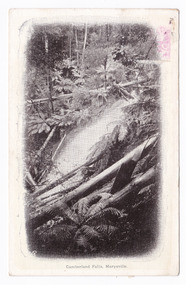
Postcard (item) - Black and white postcard, Nicholas John Caire, Cumberland falls, Marysville, 1858-1918
One of a series of postcards of photographs taken by socialite photographer Nicholas John Caire. N.J. Caire had a great love for the area and in the late 1800's took many photographs of Marysville and its surrounds.One of a series of postcards of photographs taken by socialite photographer Nicholas John Caire. N.J. Caire had a great love for the area in and surrounding Marysville and in the late 1800's took many photographs of Marysville and its surrounds. N.J. Caire was born in 1837 in Guernsey. He arrived in Adelaide about 1860 along with his parents who encouraged his early interest in photography. He opened a studio in Adelaide in 1867 after traveling extensively throughout the Gippsland taking photographs. After marrying in 1870 he moved to Talbot in Victoria until 1876 when he opened a studio in the Royal Arcade in Melbourne. After 1885 N.J. Caire gave up his city work and made his home in South Yarra and devoted the rest of his life to outdoor photography, specializing in the bush, the gullies and the mountains of south-eastern Victoria. Victorian one penny postage stamp Post Card The Address to be written on this side This space may be used for Correspondence/ within the Commonwealth at 1d rate./ Foreign, charged ordinary letter rate. AFFIX STAMP/ HERE Dear Mum/ Will you bring me/ over some/ milk. I cannot/ get any here./ Love to all/ from all/ Hilda Mrs Gregory/ Bay View Hotel/ Frankstonmarysville, victoria, nicholas john caire, postcard, souvenir, cumberland falls -
 Marysville & District Historical Society
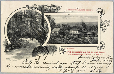
Postcard (Item) - Black and white postcard, John William Lindt, "The Hermitage on the Blacks Spur" via Healesville, Victoria, Australia: A Perfect Pleasure Resort, 1900s
A digital copy of an early black and white postcard of "The Hermitage" at Narbethong in Victoria.A digital copy of an early black and white postcard of "The Hermitage" at Narbethong in Victoria. "The Hermitage" was built by photographer John William Lindt as a home and guesthouse in 1894. John Lindt had previously photographed the mountain scenery of the Black Spur and purchased 71 acres and subseqently built his home and guesthouse from where he continued his career. "The Hermitage had a garden designed by John Lindt's friend, Ferdinand von Mueller, who was at one stage the Director of the Melbourne Botanic Gardens. The garden featured New Guinea tree houses from which John Lindt made frequent panoramas of his property and the surrounding forest of towering mountain ash. Aged 81 Lindt died of heart failure during disastrous bushfires on 19 February 1926 at the Hermitage. He was survived by his wife Catherine who continued to run ‘The Hermitage’ guest house before she retired to the city.Sandringham South/ Feb. 15th. 03/ D.L./ Only to remind you that I am coming/ As-morrow morning early about 11.15 a.m./ Greetg you L Mthe hermitage, john william lindt, narbethong, victoria, black spur, ferdinand von mueller, melbourne botanic gardens, new guinea, catherine lindt, collotype -
Marysville & District Historical Society
Document (Item) - Book extract, John (Jack) Cato, Nicholas John Caire of Melbourne-The Story of the Camera in Australia, 1955
An account of the life of Nicholas John Caire extracted from the book The Story of the Camera in Australia.An account of the life of Nicholas John Caire extracted from the book The Story of the Camera in Australia. Nicholas John Caire was born in 1837 in Guernsey. He arrived in Adelaide about 1860 along with his parents who encouraged his early interest in photography. He opened a studio in Adelaide in 1867 after traveling extensively throughout the Gippsland taking photographs. After marrying in 1870 he moved to Talbot in Victoria until 1876 when he opened a studio in the Royal Arcade in Melbourne. After 1885 Nicholas John Caire gave up his city work and made his home in South Yarra and devoted the rest of his life to outdoor photography, specializing in the bush, the gullies, and the mountains of south-eastern Victoria. nicholas john caire, john (jack) cato, the story of the camera in australia -
 Marysville & District Historical Society
Photograph (Item) - Black and white photograph, 1900s
A digital copy of a black and white portrait of Nicholas John Caire.A digital copy of a black and white portrait of Nicholas John Caire. Nicholas John Caire was born in 1837 in Guernsey. He arrived in Adelaide about 1860 along with his parents who encouraged his early interest in photography. He opened a studio in Adelaide in 1867 after traveling extensively throughout the Gippsland taking photographs. After marrying in 1870 he moved to Talbot in Victoria until 1876 when he opened a studio in the Royal Arcade in Melbourne. After 1885 Nicholas John Caire gave up his city work and made his home in South Yarra and devoted the rest of his life to outdoor photography, specializing in the bush, the gullies, and the mountains of south-eastern Victoria. nicholas john caire -
 Marysville & District Historical Society
Photograph (Item) - Black and white photograph, 1900s
A digital copy of a black and white portrait of Nicholas John Caire.A digital copy of a black and white portrait of Nicholas John Caire. Nicholas John Caire was born in 1837 in Guernsey. He arrived in Adelaide about 1860 along with his parents who encouraged his early interest in photography. He opened a studio in Adelaide in 1867 after traveling extensively throughout the Gippsland taking photographs. After marrying in 1870 he moved to Talbot in Victoria until 1876 when he opened a studio in the Royal Arcade in Melbourne. After 1885 Nicholas John Caire gave up his city work and made his home in South Yarra and devoted the rest of his life to outdoor photography, specializing in the bush, the gullies, and the mountains of south-eastern Victoria. N.J. Cairenicholas john caire -
 Marysville & District Historical Society
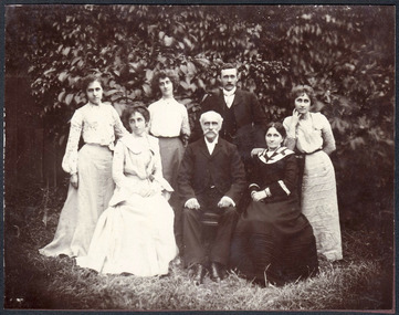
Photograph (Item) - Black and white photograph, 1900s
A digital copy of a black and white photograph of Nicholas John Caire, his wife Louisa, and their five adult children.A digital copy of a black and white photograph of Nicholas John Caire, his wife Louisa, and their five adult children. Nicholas John Caire was born in 1837 in Guernsey. He arrived in Adelaide about 1860 along with his parents who encouraged his early interest in photography. He opened a studio in Adelaide in 1867 after traveling extensively throughout the Gippsland taking photographs. After marrying Louisa Master in 1870 he moved to Talbot in Victoria until 1876 when he opened a studio in the Royal Arcade in Melbourne. After 1885 Nicholas John Caire gave up his city work and made his home in South Yarra and devoted the rest of his life to outdoor photography, specializing in the bush, the gullies, and the mountains of south-eastern Victoria. nicholas john caire, louisa master, louisa caire -
 Marysville & District Historical Society
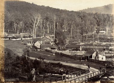
Photograph (Item) - Black and white photograph, Nicholas John Caire, 1883
An early black and white photograph of the township of Marysville in Victoria.An early black and white photograph of the township of Marysville in Victoria. This photograph of Marysville was taken by Nicholas John Caire in 1883. Nicholas John Caire was born in 1837 in Guernsey. He arrived in Adelaide about 1860 along with his parents who encouraged his early interest in photography. He opened a studio in Adelaide in 1867 after traveling extensively throughout the Gippsland taking photographs. After marrying in 1870 he moved to Talbot in Victoria until 1876 when he opened a studio in the Royal Arcade in Melbourne. After 1885 Nicholas John Caire gave up his city work and made his home in South Yarra and devoted the rest of his life to outdoor photography, specializing in the bush, the gullies, and the mountains of south-eastern Victoria. nicholas john caire, marysville, victoria -
 Marysville & District Historical Society
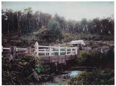
Photograph (Item) - Colour tinted photograph, 1878-1904
A copy of an early colour tinted photograph of a wooden bridge in Marysville in Victoria.A copy of an early colour tinted photograph of a wooden bridge in Marysville in Victoria. This photograph was taken by Nicholas John Caire between 1878 and 1904. Nicholas John Caire was born in 1837 in Guernsey. He arrived in Adelaide about 1860 along with his parents who encouraged his early interest in photography. He opened a studio in Adelaide in 1867 after traveling extensively throughout the Gippsland taking photographs. After marrying in 1870 he moved to Talbot in Victoria until 1876 when he opened a studio in the Royal Arcade in Melbourne. After 1885 Nicholas John Caire gave up his city work and made his home in South Yarra and devoted the rest of his life to outdoor photography, specializing in the bush, the gullies, and the mountains of south-eastern Victoria. nicholas john caire, marysville, victoria -
 Marysville & District Historical Society
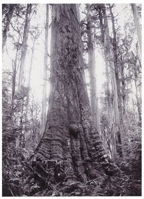
Photograph (item) - Black and white photograph, Nicholas John Caire, 1878-1904
An early black and white photograph of a Cumberland Valley giant tree.An early black and white photograph of a Cumberland Valley giant tree. This photograph was taken by Nicholas John Caire between 1878 and 1904. Nicholas John Caire was born in 1837 in Guernsey. He arrived in Adelaide about 1860 along with his parents who encouraged his early interest in photography. He opened a studio in Adelaide in 1867 after traveling extensively throughout the Gippsland taking photographs. After marrying in 1870 he moved to Talbot in Victoria until 1876 when he opened a studio in the Royal Arcade in Melbourne. After 1885 Nicholas John Caire gave up his city work and made his home in South Yarra and devoted the rest of his life to outdoor photography, specializing in the bush, the gullies, and the mountains of south-eastern Victoria. big tree, mountain ash, cambarville, victoria, photograph, cumberland valley, nicholas john caire -
 Marysville & District Historical Society
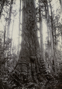
Photograph (Item) - Black and white photograph, Nicholas John Caire, 1878-1904
Shows two men measuring around the base of a Cumberland Valley giant tree. An early black and white photograph of a Cumberland Valley giant tree. This photograph was taken by Nicholas John Caire between 1878 and 1904. Nicholas John Caire was born in 1837 in Guernsey. He arrived in Adelaide about 1860 along with his parents who encouraged his early interest in photography. He opened a studio in Adelaide in 1867 after traveling extensively throughout the Gippsland taking photographs. After marrying in 1870 he moved to Talbot in Victoria until 1876 when he opened a studio in the Royal Arcade in Melbourne. After 1885 Nicholas John Caire gave up his city work and made his home in South Yarra and devoted the rest of his life to outdoor photography, specializing in the bush, the gullies, and the mountains of south-eastern Victoria. big tree, mountain ash, cambarville, victoria, photograph, cumberland valley, nicholas john caire -
 Flagstaff Hill Maritime Museum and Village
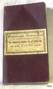
Financial record - Bank Transaction Book, Commercial Banking Company of Sydney Limited, before 1931
The financial account book was used by the Warrnambool Harbour Board for its Emergency Account. It records transactions made with The Warrnambool branch of the Commercial Banking Company of Sydney Limited during the year 1931. The Secretary of the Warrnambool Harbour Board would have used this book in 1931. James Menzies, Pilot arid Harbour Master from 1929, was appointed as Acting Secretary for the Board in 1932 and held this office until the Board ceased in 1936. Warrnambool’s CBC Manager during this time was L E Whitney; he was Manager from 1924 to 1939. The Commercial Banking Company of Sydney Limited opened in 1893. On January 1, 1927 the CBC amalgamated with the Bank of Victoria. In 1981 the CBC merged with the National Bank of Australasia Limited and on January 1, 1983 the bank started using the abbreviated name of the National Australia Bank (NAB). Warrnambool Harbour Board- The Warrnambool Harbour Board was constituted by Order of Council on May 29, 1928, under the Harbour Board’s Act of 1927, taking over from the Ports and Harbours Branch of the Public Works Department of Victoria. The Board was then the only body with power to manage and control the whole Port, including shipping, facilities upkeep and improvements of the port. The work it carried out involved dredging, building of port facilities and drafting of port regulations, and collecting taxes, tolls, rates and charges. The Board was officially dissolved on June 30, 1936, at which time the Public Works Department again had control. The Warrnambool Harbour Board had rented out the Lighthouse Keeper’s Quarters from the 1920s until 1936, when the Board closed down. However, rentals continued with other currently unknown landlords until Flagstaff Hill Maritime Village opened in 1975 and began renovating the Cottage, in stages. Text on the fly page of the book is as follows – “The Commercial Banking Company of Sydney Limited with which is Amalgamated THE BANK OF VICTORIA LIMITED. Head Office – SYDNEY. Melbourne Office: 237 COLLINS STREET. BANKING Business of every description transacted. BRANCHES throughout VICTORIA, NEW SOUTH WALES and QUEENSLAND, and ADELAIDE BRANCH, SOUTH AUSTRALIA, and AGENCIES throughout AUSTRALASIA and NEW ZEALAND on which DRAFTS AND LETTERS OF CREDIT Are issued and also on LONDON BRANCH and AGENCIES in all the PRINCIPAL CITIES of the world. Telegraphic Remittances made, Bills Negotiated or Forwarded for Collection, Advances made, Deposits received, Current Accounts kept. FURTHER PARTICULARS ON APPLICATON. “ This bank transaction book is of local and state significance for its association with the Port of Warrnambool and the Warrnambool Harbour Board. The Warrnambool Harbour Board was the only board formed under the 1927 Harbour Boards Acts, even though other Victorian ports were eligible. The book is also significant as an example of bank records used by Australian and overseas branches of the Commercial Banking Company of Sydney Limited, and the Bank of Victoria Limited.Maroon coloured rectangular book with textured cover and cream coloured label attached. Label has a printed title on book plus hand written titles added in black and red. The corners of the book are rounded. The white pages have pre-printed text and lines. The book was used for transactions between the Warrnambool Harbour Board’s Emergency Account and the Commercial Banking Company of Sydney Limited during the year 1931.Handwritten in black “WARRNAMBOOL HARBOUR BOARD “, “EMERGENCY A/C” Printed in black “IN ACCOUNT CURRENT WITH”, “The Commercial Banking Coy. Of Sydney Ltd.”, “WITH WHICH IS AMALGAMATED”, “THE BANK OF VICTORIA LIMITED”, “Page …”warrnambool, shipwrecked-coast, flagstaff-hill, flagstaff-hill-maritime-museum, maritime-museum, shipwreck-coast, flagstaff-hill-maritime-village, warrnambool harbour board, financial account, emergency account, financial record, commercial banking company of sydney limited, 1931 bank book, bank of victoria limited, transaction book, financial management, stationery, deposit book, public works department, ports and harbours, commercial banking company of sydney ltd., james menzies, harbour master, l e whitney, cbc manager warrnambool, harbour board act, port of warrnambool, warrnambool harbour, lady bay, harbour pilot -
 Glen Eira Historical Society
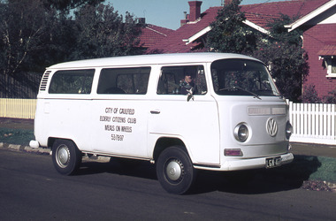
Album - Page 1 of folder D-F, Caulfield Municipality Photo Slide Collection, c.1976 - c.1994
The photographs for the slides are believed to have been taken by the inaugural Editor for the Caulfield Contact - the official newspaper of the former City of Caulfield from 1976-1994. The Editor was also Council's Community Liaison Officer and she (and her successor) took many photographs of official events and Council-related services and locations in connection with both these official roles. The City of Caulfield was the Municipal Council for an area of the South Eastern suburbs of Melbourne, including Brighton East, Carnegie, Caulfield, Elsternwick, Gardenvale, Glen Huntly, McKinnon, Murrumbeena, Ormond and St Kilda East. Credit: Glen Eira Historical Society - This item was digitised and made available through the Glen Eira Heritage Digitisation Strategy 2019-2023. Glen Eira Historical Society acknowledges the support of Glen Eira City Council. Caulfield’s Meals on wheels project started in 1958 and was run by volunteers. By 1974 Caulfield Council assumed responsibility for the administration of the service which by then was the largest in Victoria, supplying 300 meals each weekday. By 1987 with a combination of both paid and volunteer staff up to 136,000 meals were distributed each year to individual homes and to various clubs and organizations. Page 1 of slide album D to F, in a polypropylene slide sleeve containing 19 x 35mm colour slides. A sample of 8 images from this page is included. meals on wheels, glen eira city council, local government, caulfield city council, caulfield council, city of caulfield, council services, brighton east, carnegie, caulfield, elsternwick, gardenvale, glen huntly, mckinnon, murrumbeena, ormond, st kilda east, caulfield municipality photo slide collection -
Glen Eira Historical Society
Album - Folder D-F, Caulfield Municipality Photo Slide Collection, c.1976 - c.1994
The photographs for the slides in this album (one of several related albums) are believed to have been taken by the inaugural Editor for the Caulfield Contact - the official newspaper of the former City of Caulfield from 1976-1994. The Editor was also Council's Community Liaison Officer and she (and her successor) took many photographs of official events and Council-related services and locations in connection with both these official roles. The City of Caulfield was the Municipal Council for an area of the South Eastern suburbs of Melbourne, including Brighton East, Carnegie, Caulfield, Elsternwick, Gardenvale, Glen Huntly, McKinnon, Murrumbeena, Ormond and St Kilda East. Credit: Glen Eira Historical Society - This item was digitised and made available through the Glen Eira Heritage Digitisation Strategy 2019-2023. Glen Eira Historical Society acknowledges the support of Glen Eira City Council.Large blue plastic 3-ring binder containing 13 pages (20 pockets) of up to 20 coloured slides per page; some images may be reversed. Page 11 is an envelope containing film only. Some images are not of the Caulfield or Glen Eira municipal area.Labelled as D to F on spine of folder.glen eira city council, city of caulfield, council services, brighton east, carnegie, caulfield, elsternwick, gardenvale, glen huntly, mckinnon, murrumbeena, ormond, st kilda east, caulfield municipality photo slide collection -
 Glen Eira Historical Society
Album - Page 8 of folder D-F, Caulfield Municipality Photo Slide Collection, c.1976 - c.1994
The photographs for the slides are believed to have been taken by the inaugural Editor for the Caulfield Contact - the official newspaper of the former City of Caulfield from 1976-1994. The Editor was also Council's Community Liaison Officer and she (and her successor) took many photographs of official events and Council-related services and locations in connection with both these official roles. The City of Caulfield was the Municipal Council for an area of the South Eastern suburbs of Melbourne, including Brighton East, Carnegie, Caulfield, Elsternwick, Gardenvale, Glen Huntly, McKinnon, Murrumbeena, Ormond and St Kilda East. Credit: Glen Eira Historical Society - This item was digitised and made available through the Glen Eira Heritage Digitisation Strategy 2019-2023. Glen Eira Historical Society acknowledges the support of Glen Eira City Council. Page 8 of slide album D to F, in a polypropylene slide sleeve containing 20 x 35mm colour slides. A sample of 7 images from this page is included. glen eira city council, local government, caulfield city council, caulfield council, city of caulfield, caulfield contact, council services, brighton east, carnegie, caulfield, elsternwick, gardenvale, glen huntly, mckinnon, murrumbeena, ormond, st kilda east, caulfield municipality photo slide collection, roads and streets, north road, murrumbeena road, neerim road, queens avenue, sports and recreations, tennis, petrol stations, alma road, orrong crescent, caulfield north, east boundary road -
Glen Eira Historical Society
Article - COANE, JOHN MONTGOMERY
This file contains one item about Coane and his family: 1/A one page extract from The Australian Dictionary of Biography Vol. 8 page 35 on John Montgomery Coane, Surveyor and Consulting Engineer, his partnership with George Hudson and later when his two sons joined the business. It details many of the projects he designed for rural Victoria and New South Wales and his other areas including Consulting to The Pacific Phosphate Co. Ltd of London and to the City of Brighton where he lived.coane john montgomery, blacker’s orchard & cannery co., victorian institute of surveyors, county donegal, ireland, mordialloc, ballyshannon, mines department sludge abatement board, coane henry edward, surveyors, engineers, land surveyors board, coane henry james, j.m. and h.e. coane, coane jane nee montgomery, coane john montgomery junior, victorian education department, australian roads, collas emma anna hunt, books, grant george hudson, coutie b.m., state electricity of victoria, melbourne, epsom racecourse, racecourses, brighton, city of brighton, brighton re-adaptation society, brighton cemetery, cemeteries, southern roger j, australian dictionary of biography vol. 8, early settlers -
Glen Eira Historical Society
Book - MOORABBIN
One item about Moorabbin: 1/An A4 directory of services, clubs, organisations, amenities, sport and recreation facilities, and associations within the Moorabbin City Council’s locality. It has been produced by the City Council in 1987directories, city of moorabbin, sports and recreations, establishment, clubs, local government, clubs and associations, sport and recreation, service clubs, businesses, sporting, social services, social clubs, community services, community centres, community groups, community organisations, east ormond, south oakleigh, moorabbin, patterson, mckinnon, ormond, bentleigh, bentleigh east -
Glen Eira Historical Society
Letter - South Caulfield Hebrew Congregation
A letter dated 30 March 1977 to Mr John Wells from Rabbi S. Rudzki thanking John concerning material for John’s book on City of Caulfield. There attached Rabbi. S. Rudzki contact details if anything further is required.wells john. c, south caulfield hebrew congregation, rudzki s rabbi, leopold street, south caulfield, city of caulfield -
Glen Eira Historical Society
Document - Glen Eira Residents Association
Six items pertaining to Glen Eira Residents Asssociation Inc. 1/Two copies of the minutes of a Committee Meeting of Glen Eira Residents Association Inc., held on 04/12/2001. The minutes cover a range of routine meeting items, as well as the postponed release of the Princes Park Master Plans and the proposed construction of car parks at Caulfield Racecourse. 2/A copy of Glen Eira Residents’ Association Inc.’s 30/05/2003 newsletter, notifying members of matters presently before Glen Eira City Council for purposes of evaluation. Matters include an admonishment to the Council to sort out anomalies between the C25 Amendment (80/20 Plan) and the Melbourne 2030 Plan, the success at convincing the Ministerial panel to adopt GERA’s views regarding the C14 Council Plan for the Caulfield Racecourse, a request for information from the Council regarding the previous year’s rate increase, a request for information from the Council regarding spending on planning for improvements to Princes Park, a call for the Council to improve its consultative procedures, a recommendation that the purpose of Glen Eira News be expanded to the making of suggestions for city improvement, and a notification of the measures implemented to improve the visibility of Caulfield Racecourse’s usability by the public. Includes a black-and-white photograph of Orrong Road, Elsternwick, illustrating what Glen Eira’s roads would look like if lined with trees, which was excluded from Glen Eira News on account of a current prohibition on the making of suggestions for city improvements. 3/Four copies of a booklet entitled ‘A Short Guide to Planning Procedures’, composed 08/2006, which endeavours to explain, as concisely as possible, the methodology by which Glen Eira City Council approves real estate developments and issues planning permits. 4/A booklet containing the minutes of the 05/10/2009 Annual General Meeting of Glen Eira Residents’ Association Inc. Details both routine items and more specific matters of discussion, such as inappropriate charges on the part of the Glen Eira City Council and the proposed inception of a questionnaire to evaluate local residents’ opinion of the Council. 5/A booklet announcing the 07/10/2010 Annual General Meeting of Glen Eira Residents’ Association Inc. at St. John’s Uniting Church, Elsternwick. Front cover details agenda and contains four colour photographs pertaining to public transport (buses, trams, trains) within the city. Interior features president Don Dunstan reflecting on issues relevant to GERA occurring over the preceding twelve months, with an emphasis on the dubious behaviour of the City Council, as well as two colour photographs: one of Dunstan himself and one of traffic at Elsternwick Junction. The rear cover contains the Financial Statement presented to the Meeting. 6Two copies of a printout of an article from the website of Glen Eira Residents’ Association Inc., accessed 19/06/2012, explaining the affects wrought as a result of the implementation of Planning Scheme Amendment C87. Said amendment changes the Planning Scheme protecting neighbourhood character by replacing the previous Significant Character Area (SCA) designation with the new designations of Neighbourhood Character Overlay (NCO) and Design and Development Overlay (DDO). In developing the Amendment, Glen Eira City Council commissioned Planisphere to procure the Planisphere Final Report, in which recommendations regarding the expansion, creation and deletion of SCAs were offered. The article contains a summary of said recommendations.glen eira residents’ association inc., clubs and associations, glen eira, meetings, minutes, campbell jack, dunstan don, marwick geoff, pleydell max, teseriero dominic, robins kevin, princes park, south caulfield, glen eira city council, local government, councillors, brennan martin, victorian local government association (vlga), erlich mayor, project manikato, caulfield racecourse, caulfield racecourse flat, racecourses, parks, car parks, kennedy cr., kennedy norman mr., crown land, glen eira road, rippon lea, c25 plan (80/20), melbourne 2030 plan, c14 council plan, rates, orrong road, elsternwick, trees, station street, caulfield north, neerim road, glenhuntly, glenhuntly park, orrong ward, grossbard cr., martens cr., building permits, delegated planning committee (dpc), steward joy, brohier peter, campbell fliss, scutt alex, ray darren, hannah brian, st. john’s uniting church, mees paul dr., elsternwick club, sandham street, melbourne weekly bayside, glen eira debates, walsh investigation, whelen investigation, forge cheryl cr., whiteside helen mayor, save our suburbs (sos), walsh mary, walsh kevin, french christine, elsternwick junction, planning scheme, planning scheme amendment c87, significant character areas (scas), planisphere final report, oakdene crescent, carnegie, blackwood street, housing diversity areas, urandaline grove, caulfield, normanby road/park crescent, kambrook road, balaclava road, hawthorn road tramway estate, caulfield south, ulupna road, ormond, murray street, prentice street, kambea grove, chestnut street, mcpherson avenue, queens avenue, caulfield east, derby crescent, clarinda street, st. james parade/downshire road, exhibition street, mckinnon, field street, boyd park, murrumbeena, lindsay avenue, lydson street -
Glen Eira Historical Society
Article - South Caulfield Cricket Club
This file has two items. Newspaper article on South Caulfield Cricket Club as VTCA twenty champions for seasons 2012, includes photograph of team. Handwritten details giving club address and website from Glen Eira City Council’s resident handbooks by Claire Barton dated 16/08/2013.south caulfield cricket club, princess park, princes park, pope joel, hewett christian, russel luke, grey anothony, dowling jarrad, jeffree shane -
Glen Eira Historical Society
Letter - G. J. Coles and Coy. Ltd
This file contains three items. 1. Typed letter, dated 10/06/1987, from the Coles Myer corporate archivist, Stella Barber, to Caulfield Historical Society accompanying photographs of Coles stores donated to the society. 2. Typed brief history of the Coles Myer company up to September 1986, author unknown. 3. Printed newsletter dated February 1986 of the city of Richmond and Burnley Historical Society containing a brief history of G. J. Coles and Co. Ltd by Stella Barber.g. j. coles and co. ltd., barber stella, caulfield historical society, elsternwick, caulfield, coles stores, ballantyne r., caulfield south, retail trade, shops, general stores, coles variety stores -
Glen Eira Historical Society
Article - Glenhuntly Athletic Club
Correspondence received from Victorian Athletic Association with regard to assistance given by the city of Caulfield for Victorian road running championships at Caulfield Racecourse 1987, dated 16/06/1987 An article from the Caulfield /Port Phillip Leader on Sean Wroe’s participation in the Melbourne track classic, dated 01/03/2011 An article from the Caulfield /Port Phillip Leader on the success of Glen Huntly Athletic Club at the Victorian Youth Championship , dated 08/03/2011 An article from the Caulfield /Port Phillip Leader on Glen Huntly Athletic Club’s ‘participation in the Australian 20km walk championship and the Australian Athletics tour, dated 08/03/2011 An article from the Caulfield / Port Phillip Leader on Glen Huntly Athletic Club's’ win of the HH Hunter Shield, dated ,15.03.2011 An article from the Caulfield / Port Phillip Leader on Glen Huntly Athletic Club’s wins at the Australian Junior Athletics Championship, dated 22.03.2011 An article from the Caulfield/ Port Phillip Leader on Sean Wroe from the Glen Huntly Athletic’s Club participation in the Australian Athletic’s Championship and World championship, dated 12.04.2011 An article from the Caulfield/ Port Phillip Leader on Glen Huntly Athletic’s Club’s participation in the Victorian cross country r5elay Championship, dated 17.05.2011 An article from the Caulfield /Port Phillip Leader on Sean Wroe and Kelly Hetherington representing Glen Huntly Athletic Club at the World University games in China, dated 09.08.2011 An article from the Caulfield/ Port Phillip Leader on the success of the Women from Glen Huntly Athletic Club at the Athletics Victoria road relay Championship, dated 16.08.2011 An article from the Caulfield/ Port Phillip Leader on the Sean Wroe, from the Glen Huntly Athletic Club ,bronze medal win at the World university Games in China, dated 30.08.2011 An article from the Caulfield/Port Phillip Leader on Glen Huntly Athletic Club’s participation in the Athletics Victoria summer shield series dated 25. 10.2011 An article from the Caulfield /Port Phillip Leader on the success of Glen Huntly Athletic Club at round 2 of the Summer Shield series , dated 1.11.2011 An article from the Caulfield/ Port Phillip Leader on the placing of the Glen Huntly Athletic Club at round 3 of the Summer Shield series , dated 8.11.2011 An article from the Caulfield/ Port Phillip Leader on the success of the Glen Huntly Athletic Club at round 3 of the summer shield series ,dated 22.11.2011victorian athletic association, city of caulfield, caulfield, caulfield south, glen huntly athletic club, campbell jack cr, caulfield racecourse, aylen d.r, melvin david, onley peter, etherington chris, victorian olympic council inc, sports federation of victoria inc, australian athletic union, victorian road running championship, mason gregor, clubs, associations, sports, recreations, competitions, sporting clubs, leisure, cultural events, cultural associations, running, athletics, victorian open, awd track and field championship, hh hunter shield, wroe sean, sports grounds, ovals, parks, reserves, melbourne track classic, victorian track and field championship, australian athletics, australian junior athletics championship little athletics, state track and field championship, australian athletics championship, world championship, victorian cross country relay championship, the hunters, the lady hunters, sports people, the world university games, athletics victoria, road relay championship australian commonwealth games association athletics victoria, victorian youth championship, summer shield series, entertainment, carter matt, krawitz shaun, nelson jordan, dillon hunter jonathan, cowley rhydian, satupai margaret, mulhall kim, clarken lielani, lappin. jake gallagher jessica, kauffman jessica, hoilten ruby, edwards julia, thompson noni, rarasinghe kulan, fountain erica, seibold- crosbie kate, offereins ben, moore kevin, milburn joel, steffensen john, rouge-serret aaron, hetherington kelly, kingdom trychelle, ryde michael, flook, isabella, debonolt kayla, nakase taishi, lund sarah, cuttler claire, santa jason, alves francesca, lagreca marcus, nomikoudis maria, brammer ally, kolokythas keelan, clarksen oisin, hibbert chris, green ellia, palackic ian, nakase kaori, edwards nicholas, globan like, mc lean emily, anthony nicola, robertson adelaide, lang chynea, mac lean tom, hart darren, kanneh vandy, wiseman angus, thompson riley, montag jemima, watson sasha, mouratch daniel, montag piper, brammer bridget, mc donald geogie, mckenzie charlotte, kelaart oliver davis nicola, katsanevakis katherine, fyfe karinna, dick kylie, thompson anna, dennett belinda, corcoran bridget, beech georgina, fletcher robyn, grimes lesley, nakase paulg, suteau frederic, bowly simon, bott justin, radose vic nenad, lelehan shaun, weatherall bridget, cook meredith, higham cassie, bennett belinda, macknamara peter, harvey mattew, miller brendan, golonka kurt, robertson hamish, byrne angela, soderstrom roland, mcinnes simone, lang beau, hodgens ben, shephert jarrod, crane jordon, beadman mackenzie, russo antonio, doran anthony, hanrahan justin, cohen justin, allen linda, austin juliet, lang beau, little william, arthur mikhalla, roberts amy rose, beraun patrick, carothers callum, byrne shane, papanikolaou joshua, cater adam, rainey helen, hutton philip, zeleznikow john, glico tim, hamilton lucy, ross anna, ione casey, phelan leigh, russo anthony, hogben lachlan, vandwater melissa, gray molly, cleary sarah, parrish katy, comport michael, parkinson nick, byrne christine, wood courtenay, macknamara kellie, axford tyse, zele znioko eva, beguely patricktelfer olivia, nomikoudis john, kelaart isabel, miller aaron, oglesby david, llewelyn hannah, hamilton daniel, holmstorm maddison, winter chris, lang jeffrey, caulfield/port phillip leader -
 Federation University Historical Collection
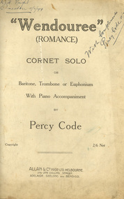
Booklet - Sheet Music, Allan & Company Pty Ltd, "Wendouree", Romance by Percy Code, 1919
This music was used by Frank Wright who had been tutored by Percy Code. Frank Wright won the Australian Open Cornet Championship using this music, and won the gold medal for the highest mark in the British Colonies. Percy Code was born in Melbourne on 03 July 1888. He started learning the violin and piano at the age of eight. Three years later his father, Edward, started tutoring him on the cornet. His first competition was in October 1902 in Ballarat's South Street Competitions. Percy Code was Musical Director of Ballarat City Brass Band from 1913 until 1921. He was Frank Wright's teacher. Code apparently lived in a large house just west of where St Peter's church (Ballarat) now stands. Percy Code toured the world as principal cornet with the 'Besses o' th' Barn Band.' He returned to Australia in 1912. Frank Wright at one stage rode his pushbike from Smeaton to Ballarat for lessons. Leaving Australia for America in March 1921 Percy Code obtained an appointment as trumpet soloist for the 70 piece San Francisco Symphony Orchestra. He returned home two years later and became bandmaster to the Prahran City Band in 1925. From 1938, as part of Australia's Sesqui Centenary celebrations, Percy Code conducted the Sydney Symphony Orchestra for the ABC orchestral concerts in Sydney Town Hall. His career with the ABC came to an end in late 1951 due to poor health. Percy Code died on 17 October 1953. From 'Legend in Brass' with additions from Bob Pattie of the Ballarat Brass Band.11071.1 Four cream pages containing handwritten title page in front, two sheet music pages inside and blank back cover. 11071.2 Eight cream pages containing front page typed title with handwritten text at top, Six pages of sheet music cream pages, with parts for piano and cornet, with black printed notes. A photograph of the composer Mr Percy Code is glued into the first page at the top left hand corner. The back cover page has advertisements for four music albums from Allan & Co. Prop. Ltd..1) Front page handwritten in blue pen and pencil. Hand written notations in pencil for cornet throughout sheet music pages. Frank Wright Smeaton 15 July 1919 in top right hand corner; Champion Bb cornet solo South Street 1919 in top left hand corner. Under title on front page: Handwritten notes in pencil giving results of competition and judge's comments. 2) Frank H. Wright Smeaton 15/7/1919 handwritten in top left hand corner. "With Compliments Percy Code 15/7/1919 written diagonally in blue pen in at right hand top.cornet, frank wright, allan & co., allans music, ballarat, south street, percy code, code, wright, sheet music, "wendouree", (romance), wendouree, romance, wendouree -
 Federation University Historical Collection
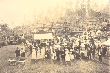
Photograph - Photograph - Black and White, Meeting for the Australian Association for the Advancement of Science, Hobart, 1892, 1892
Newspaper reports relating to the Australasian Association for the Advancement of Science, Hobart, 1892. "Australasian Association for the advancement OF SCIENCE. Several members of the Australasian Association for the Advancement of Science arrived in the city yesterday by the inter colonial steamers, some of whom went direct to Hobart, while others remained in the city, but leave for the capital this afternoon. Amongst those who arrived were Baron Von Mueller, the dis tinguished scientist, who has taken some interest in this colony's re sources, Professor W. Baldwin Spencer, M.A., professor of biology at the Melbourne University, who was general secretary at the Melbourne meeting; the Rev. Lorimer Fison, an able worker in the South Sea mission fields; Dr. Robert Giffen, L.L.D., C.ll.; Captain Pascoe, R.N.; Mr Napier Bell, C.E.; Professors Hutton, Nerich, Smith, and Morris, and Mr Richard Teece, F.T.A., the well-known actuary of the A.M.P. Society. A large number of other distinguished members also arrived. Judge Dorkerwho also arrived, was con ducted over the Exhibition in the after noon, and expressed pleasure with what he saw. His Honor leaves by express train to-day for Hobart. The hon. Dr. Campbell was met by Mr Arthur Day, the official agent for Great Britain to the Exhibition, an old friend, who conducted him over the Exhibition. The doctor confined his attention principally to the dry ore concentrator, in which he takes a great interest. He will, however, visit the Exhibition again after the meetings in Hobart has been brought to a termination. What he has seen of the Exhibition has impressed him favourably. (Launceston Advertiser, 6 January 1892.) "TASMANIA. AUSTALASIAN ASSOCIATION FOR THE ADVANCEMENT OF SCIENCE. The fourth congress of the Australasian Association for the Advancement of Science was commenced in Hobart at 11. o'olock on Thursday by the general Council assembling at the Royal Society's rooms, at the Museum. There was a good attendance, including the Governor, Sir B. G. Hamilton. In the absence of the president, Sir James Hector, the chair was occupied by Baron Von Muellor. In the afternoon Lady Hamilton gave a garden party at Government House to 600 guests, including the members of the association, the Judges, the members of the Ministry, and leading citizens." (Newcastle Morning Herald & Miners' Advocate, 9 January 1892.)Two sepia photographs mounted onto charcoal mount. A group of men in hats and coats, and women in hats and long dresses assemble in front of a double story building, thought to be Henry Dobson's of Ferntree near Hobart. In the background stumps of large trees are evident. The event was a garden party held in for members of the Australasian Association for the Advancement of Science who met in Hobart in 1892. .1 F.J. Martell of the Ballarat School of Mines is seated between two women in the right hand foreground. James Oddie, with white beard and top hat, is standing in the centre foreground between two women. .2) James Oddie is standing with cane in hand on the right of the bench in the foreground of the photo. australasian association for the advancement of science, hobart, oddie, james oddie, martell, von mueller, baldwin spencer, lorimer fison, robert giffen, napier bell, arthur day, dobson, henry dobson