Showing 467 items
matching station hotel
-
 Eltham District Historical Society Inc
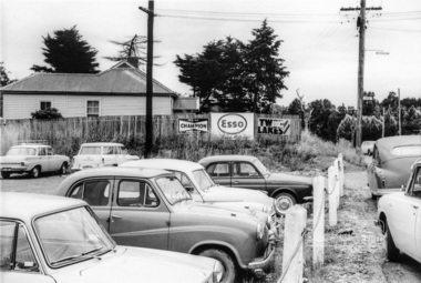
Photograph, North end of the railway station carpark, Eltham, February 1968, Feb 1968
Shows the street sign for Luck Street intersection with Main Road.In February 1968 an unknown person took a series of photos from the Eltham Hotel at Pitt Street heading north along Main Road through the shopping centre to just north of Elsa Court covering the length of the section of Main Road which was duplicated shortly thereafter. Shows the condition and environment of the streesscape of Main Road, Eltham immediately prior to the duplication between Pitt Street and Elsa Court through the shopping centre. Also shows a number of shops and businesses that operated at that time.Black and white photographduplication, eltham, main road, carparks, luck street, railway station -
 Eltham District Historical Society Inc
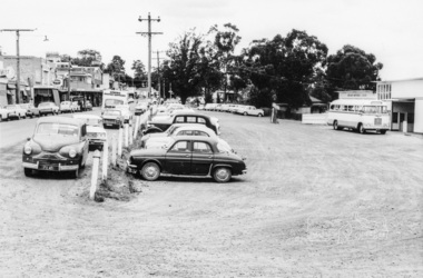
Photograph, Looking south across to the shopping centre from the west side of Main Road, Eltham, February 1968, Feb 1968
Shows Bryant Motors beside Railway Station.In February 1968 an unknown person took a series of photos from the Eltham Hotel at Pitt Street heading north along Main Road through the shopping centre to just north of Elsa Court covering the length of the section of Main Road which was duplicated shortly thereafter. Shows the condition and environment of the streesscape of Main Road, Eltham immediately prior to the duplication between Pitt Street and Elsa Court through the shopping centre. Also shows a number of shops and businesses that operated at that time.Black and white photographduplication, eltham, main road, luck street, bryant motors, buses -
 Eltham District Historical Society Inc
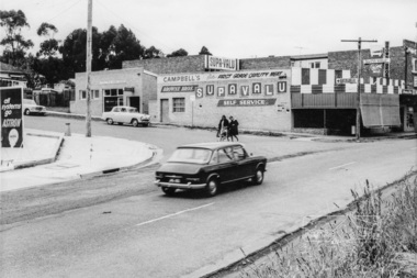
Photograph, Intersection of Main Road and Luck Street, Eltham, February 1968, Feb 1968
Shows the Supa-Value self-service shop with Campbell's Meats and the TAB. In February 1968 an unknown person took a series of photos from the Eltham Hotel at Pitt Street heading north along Main Road through the shopping centre to just north of Elsa Court covering the length of the section of Main Road which was duplicated shortly thereafter. Shows the condition and environment of the streesscape of Main Road, Eltham immediately prior to the duplication between Pitt Street and Elsa Court through the shopping centre. Also shows a number of shops and businesses that operated at that time.Black and white photographduplication, eltham, main road, luck street, caltex service station, campbell's meats, supa-value self service, tab -
 Eltham District Historical Society Inc
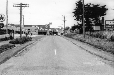
Photograph, Looking south along Main Road from Diamond Street Railway Crossing, Eltham, February 1968, Feb 1968
Luck Street enters Main Road from the left behind the Caltex garage. Note the house on right hand land.In February 1968 an unknown person took a series of photos from the Eltham Hotel at Pitt Street heading north along Main Road through the shopping centre to just north of Elsa Court covering the length of the section of Main Road which was duplicated shortly thereafter. Shows the condition and environment of the streesscape of Main Road, Eltham immediately prior to the duplication between Pitt Street and Elsa Court through the shopping centre. Also shows a number of shops and businesses that operated at that time.Black and white photographduplication, eltham, main road, diamond street, railway line, railway crossing, caltex service station, supa-value self service -
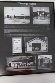 Kiewa Valley Historical Society
Posters - "Tawonga Remembers" x 4
The town of Tawonga is in the Kiewa Valley surrounded by farmland. It is adjacent to Mt Beauty (built in 1946), an SECV town built for the workers on the Kiewa Hydro Electric Scheme which was being constructed from 1911 to 1961. Tawonga consisted of essential amenities including a store, school, butter factory, sporting facilities, post office, hall and hotel. Activities involved sport, social get togethers eg. dances, fundraising, CWA etc.The posters are a collection of historical photos, documentation and information regarding the history of the town of Tawonga,which is the centre of a farming community in the Kiewa Valley.Poster framed with thin black plastic strip, covered, by glass. Each one has a title re "Tawonga Remembers" and includes print and phtots in black and white. Black background. 1. Tawonga SEC Depot; 2. Tawonga Service Station circa 1940s; 3. George Johnston's Taxi Service; 4. Tawonga Motors 1950-60stawonga, photos of early tawonga, kiewa valley, tawonga remembers, transport -
 Eltham District Historical Society Inc
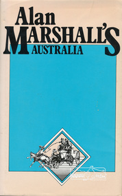
Book, Hyland House, Alan Marshall's Australia, 1981
One of a collection of books by local writer Alan Marshall held at EDHS. This one is of "anecdotes and yarns" as described by Marshall before its publication in July 1981 in the Canberra Times. Alan Marshall's Australia, the Australia of "I Can Jump Puddles" has vanished. No longer do we have time to sit on the sliprail and exchange yarns, to drive buggies down long, quiet dusty roads, or to watch the king-hit merchant operating in some small hotel. Even the Cu-nims hold no terrors for a Boeing 427! And yet - Alan Marshall's Australia lives for all those who read this book. Meet Lance Skuthorpe who tethered an old bull in Bourke Street and offered £5 to anyone who could ride it for half a minute and Binjarrpooma, the Arnhem Land terror. Accompany Alan in his horse-drawn caravan or buggy to country sales, pubs and stations and listen with him to great bush eccentrics, lairs and yarn spinners. Go further back and remember Conversation Lollies, the cigarette cards you collected and the school yard games. Can you recall how to test an axe blade, choose a pocket knife, or the penetrating power of Goanna Oil? But this book is more than a nostalgic journey into the past ; it is history for the young and a timely reminder for us all - it is our roots. - Front end papers viii, 165 p. : ill. ; Two copiesISBN 0908090390alan marshall, prose, short stories, ancedotes, australia, tales, yarms -
 Eltham District Historical Society Inc
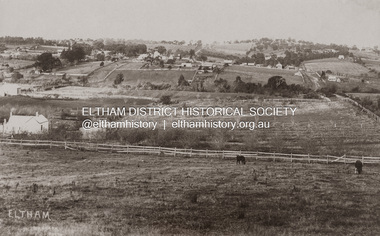
Photograph - Photograph postcard, J.H. Clark, Eltham (from Bolton Street), c.1915
Original sepia photo postcard of early view of Eltham looking east from Bolton Street between Bridge Street and Brougham Street (Wellington). Fenced road reserve on right is Brougham Street. Originally dated as pre-1877 introduction of the Telegraph (the Telegraph was connected to the Post Office on Thursday, June 7, 1877) given the lack of poles and wires visible, a more recent higher resolution scan has revealed more detail highlighting the presence of several Telegraph poles: one about half way between Brougham Street and Dalton Street, one opposite the Police Residence, another opposite W.B Andrew’s Corn Store (Zen Den site), one possibly near the Fountain/Evelyn Hotel. Also, given the photo was originally marked “J. H. Clark Photo” it is safer to assume the image is dated circa 1915 until dates of further image details can be confirmed. Photographer: J.H. Clark John Henry Clark was the youngest of three boys born to William Henry Clark (1823-1877) and Maria White (1843-1914). He and his brothers, William Charles Clark (1872-1945), Clement Kent Clark (1874-1912) operated a photography business (Clark Bros.) from 25 Thomas Street, Windsor near Prahran during the period c.1894 to 1914. Following death of Clement in September 1912 and their mother in 1914, the Clark Bros business appears to have dissolved, the premises demolished, and a new house was under construction in 1915. John set up business independently in 1914 operating out of 29 Moor Street, Fitzroy where he is registered in the 1914 and 1915 Electoral Rolls. By 1916 John had relocated to Eltham where he continued his practice as a photographer and took many of the early images around the district of Little Eltham. Around 1930 John changed professions and opened a small cobbler's shop in 1931 near the pond opposite Dalton Street adjacent to the Jarrold family cottage. He never married and continued his profession as a bootmaker from this little shop, maintaining a close relationship with Mrs Jarrold for the rest of their lives. His bootmaker shop remains today beside the Whitecloud cottage and is one of only three remaining shops in the area from the early 20th century. There are a couple of images of Eltham taken by Clark Bros. in the Eltham District Historical Society collection, one such example being Hunniford’s Post Office with Miss Anne Hunniford out front (EDHS_00140 - marked on the back of the print, Clark Bros., 25 Thomas St. Windsor), which would date this image between c.1894 and 1914. Other early images of Eltham taken by John Henry Clark are marked on the face “J. H. Clark Photo” and it is assumed these are dated between 1914 and 1930. It is noted that the Grant of Probate for John H Clark of Eltham South dated 5 April 1957 (513/387) records his occupation as "X Photographer".1. Original sepia postcard - water damaged lower left corner over approximate 30mm diameter destroying image and photohgrapher's markings (same as EDHS_00533 and EDHS_00535 - all from same donor collection) 2. A second black and white print copy of the same image from a different unknown source (of lower resolution quality) is also held. 3. A digital enhanced version has been created using the lower quality black and white print as a donor source for the damaged section of the postcard.In pencil on back of postcard: A. Petrie Verandah on Andrews shop Pearsons house (Living and Learning Centre)bolton street, brougham street, cafe zen den, courthouse, eltham courthouse, eltham hotel, eltham living and learning centre, eltham living and learning, eltham, fountain hotel, j.h. clark photo, knapmans forge, main road, maria street, pitt street, police residence, police station, post office, st margaret’s church, w.b. andrew corn store, wellington street, early eltham, little eltham -
 Eltham District Historical Society Inc
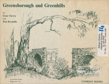
Book, Irene Turvey et al, Greensborough and Greenhills / words by Irene Turvey ; Drawings by Ron Reynolds, 1973
Pen and ink sketches accompanied by appropriate text in double page spreads. Contents cover : Blue stone bridge, Introduction, House cnr Church and Hailes Street, House - 25 Hailes Street, Yandell Reserve, Greensborough Hotel, Lobb's Kiosk, House - 49 Grimshaw Street, View of Greensborough (from Delphin Crescent), Railway Station, Old Barn (near Greensborough Railway Station), Partington's Flat and River Valley, Rand Street Bridge, Lower Main Street, Greenbriar Nursery, Hitching rail, Ashmead - Dr Cordner's Home, Greensborough Primary School, House - cnr St Helena and Diamond Creek Raods, Sondermeyer's Hill, Methodist Church, Football Pavilion, Cemetery, St Katherine's Church, St. Helena, Civic Centre, Briar Hill Timber Mill, 24 River Street, Kelly's Garden Supplies, 158 Main Street, Old Swimming pool, 105 Main Street.Hardback; 62 p. : ill., map ; 19 x 25 cm.ISBN 0909807108 Signed by author and illustrator Two copiesgreenhills, greensborough -
 Eltham District Historical Society Inc
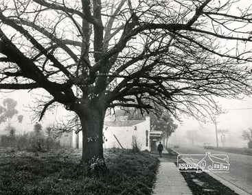
Photograph, Old Oak Tree near cnr of Franklin Street and Main Road, Eltham
Black and white photograph looking south down Main Road at a fog-shrouded view of an old large oak tree which still stands at the entrance to the Eltham Hotel car park. Antiques store in centre now Cafe Zen Den (2017) and across the road is the Mobil Service Station, now a commercial business centrepioneers and painters, main road, franklin street, eltham -
 Eltham District Historical Society Inc
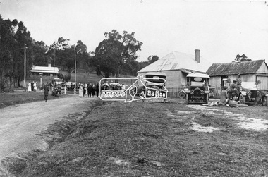
Photograph, Albert Jones, Returned soldiers picnic, Police Paddocks, Queenstown, c.1916
Queenstown (St Andrews) looking towards Panton Hill . A picnic is taking place. Streetscape with dirt road, buildings, Model T Fords and people. Police station far left, the gaol was behind (not visible). On the right is a boarding house according to Mr. Ninks, next to right the Mechanics Institute or library according to Miss Muller. On far right, Coach House (stables not shown) - end of coach run from Heidelberg. This is possibly a picnic for returned servicemen from Gallipoli. The house on the right still existed c.1970 and was alongside Hotel on Kinglake side. Reproduced page 35 Pioneers & Painters also on the back cover and on page 59 of "St Andrews: a village built on gold". Described in chapter headed "The Police Paddocks". This photo forms part of a collection of photographs gathered by the Shire of Eltham for their centenary project book,"Pioneers and Painters: 100 years of the Shire of Eltham" by Alan Marshall (1971). The collection of over 500 images is held in partnership between Eltham District Historical Society and Yarra Plenty Regional Library (Eltham Library) and is now formally known as the 'The Shire of Eltham Pioneers Photograph Collection.' It is significant in being the first community sourced collection representing the places and people of the Shire's first one hundred years.Digital image 4 x 5 inch B&W Neg Prints 20 x 25 and 9 x 12.5 cm sepp, shire of eltham pioneers photograph collection, queenstown, cars, police station, st andrews, model t ford, pioneers and painters, boarding house, gallipoli, picnic, police paddocks, retuned soldiers -
 Eltham District Historical Society Inc
Photograph, Tom Prior, Police Station and Residence, Maria Street, Eltham, c.1900
Situated near the top of what was known as 'Policeman's Hill' according to Miss Ivy Reynolds, neice of the photographer, Tom Prior. From the left, Eltham Court House, Police Residence and Police station on Main Road and corner of Brougham Street. These buildings formed part of Little Eltham and still stand (without the front fence) today though the Police Station was demolished in 1986 due to termite damage. A replica was built circa 1989. The institutions of law and order in Colonial Victoria included the police, courts and prisons. The 1852 report of the Snodgrass Select Committee appointed to "identify the policing needs of the colony” noted there existed seven independent police forces that did not co-operate or regularly communicate. Following the committee's report all these police entities were merged into the Victoria Police, founded on 8 January 1853, to implement law and order responsibilities throughout the Colony of Victoria. The Eltham Courthouse (1860) and adjacent Police Residence (1859) formed a justice precinct established in the immediate aftermath of the 1852 police inquiry and the effects of the gold rush. The physical presence of these buildings, in the centre of the early Eltham township, defined centralised control over law and order. In the early days the Police Constable in charge would conduct his duties travelling around the district by horse; a stable was located at the rear of the residence. At times the horse would be grazed on the paddocks across the road. Horseshoes were forged by the blacksmith beside the Courthouse on the high side of “Policeman’s Hill”. Along with the stable, there was a two-cell bluestone lockup where prisoners were held awaiting trial in the adjacent Courthouse. Their meals were usually provided by the policeman’s wife or from the hotel just up the road. With the arrival of the railway in 1902 the town centre gradually shifted towards the railway station. The Police Station and operations were moved into the town centre in 1961 to a renovated house in Pryor Street, which was later replaced by the current Police Station. From 1961-1981 the residence was occupied by the Vermin and Noxious Weeds Destruction Section of the Department of Crown Lands and Survey. Prior to August 1967 the former Police Station was dragged to the rear of Police Residence to make way for the construction of a driveway and access from Main Road. The building was placed on the site of a former Scullery and modified for Lands Department use. In 1981 the Shire of Eltham took over management of the former Police Residence in Eltham. It remained unoccupied for a period whilst its future was discussed in Council. It was then used for a community job creation scheme until 1985. In 1985 the Shire of Eltham Parks and Environment occupied the residence. Council improved the driveway but later added a second rear access from Brougham Street due to the dangerous nature of the Main Road entrance. Additionally, a rear toilet facility between the Police Residence and the relocated former Police Station, which was doubling up as a lunchroom. Council also commenced discussions to re-establish a replica Police Station. Around November 1986 the former Police Station was demolished; believed to have been suffering termite damage. About 1989, after some years of discussion, a replica Police Station was built, based on photographs, to act as a lunchroom and meeting room for the Parks and Environment staff and volunteers doing community service. In 1996 Eltham District Historical Society held discussions with Nillumbik Shire Council commissioners throughout the year regarding a home for the Society. A proposal was put forward by the Society in October to occupy the former Police Residence. In March 1997 Eltham District Historical Society gained access to former Police Residence and on July 12, 1998, moved into its Local History Centre. In July 2018, Eltham District Historical Society gained access to the replica Police Station (which had been used as a music library and storage for the Eltham Concert Band) for use as part of regular heritage tours for schools and community-based groups.This photo forms part of a collection of photographs gathered by the Shire of Eltham for their centenary project book,"Pioneers and Painters: 100 years of the Shire of Eltham" by Alan Marshall (1971). The collection of over 500 images is held in partnership between Eltham District Historical Society and Yarra Plenty Regional Library (Eltham Library) and is now formally known as 'The Shire of Eltham Pioneers Photograph Collection.' It is significant in being the first community sourced collection representing the places and people of the Shire's first one hundred years. The Reynolds family were early settlers in Research. The Reynolds/ Prior collection of photographs were taken by Tom Prior, the maternal uncle of Ivy Reynolds, around 1900 and the 60 photos in the album give a fine overview of many of the landmarks of Research and Eltham over 100 years ago. lvy lived in the family home for many years at 106 Thompson Cres Research. Ivy's father, Ernst Richard Reynolds and grandfather, Richard Reynolds, lived at the same address. Ivy's father Richard worked for Mr. Trail on his property in Research. Reynolds Road is named after the family. Mr Tom Prior (wife Eva) worked at the Melbourne zoo. He was very innovative and made his own camera, using the black cloth hood to exclude the light. The photographs are a reminder of the rural nature of Research and Eltham and its rich heritage.Digital imagechildren, court house, courthouse, eltham, eltham district historical society, eltham justice precinct, little eltham, local history centre, main road, police residence, police station, reynolds prior collection, sepp, shadow, shire of eltham pioneers photograph collection -
 Eltham District Historical Society Inc
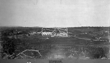
Negative - Photograph, Eltham, Vic, c.1890
View looking northeast from present day Ely Street (near intersection of present day Cronus Court and Porter Street) across what will become the site of Eltham High School towards Main Road showing the Eltham Courthouse and Police station. View is very similar to the sketch of Eltham published in 'The Illustrated Australasian News', December 26, 1884, p212. Note the large bluestone cell block behind police house and stable. George Knapman's Shoeing Forge next to the courthouse and the concentration of buildings around the Evelyn Hotel and Watson's Eltham Hotel on opposite sides of Main Road at Pitt street. Also note George Stebbing's cottage (c.1860) on Pitt Street behind the courthouse and 'Sunnyside' (home of W.J. Taylor built c.1885) at the top of the hill on Bible Street. In the foreground are orchards running up to the main street, Maria Street and also between Brougham Street and Dalton Street bordered by Bible Street.This photo forms part of a collection of photographs gathered by the Shire of Eltham for their centenary project book,"Pioneers and Painters: 100 years of the Shire of Eltham" by Alan Marshall (1971). The collection of over 500 images is held in partnership between Eltham District Historical Society and Yarra Plenty Regional Library (Eltham Library) and is now formally known as the 'The Shire of Eltham Pioneers Photograph Collection.' It is significant in being the first community sourced collection representing the places and people of the Shire's first one hundred years.Digital image 4 x 5 inch B&W Negshire of eltham pioneers photograph collection, eltham, 1890, bible street, brougham steet, dalton street, eltham courthouse, eltham hotel, evelyn hotel, franklin street, grant house, knapmans forge, main road, maria street, orchards, police residence, police station, pre 1900, stebbing cottage, sunnyside, w.b. andrew corn store, watsons hotel, little eltham -
 Ringwood and District Historical Society
Photograph, Club Hotel, Mount Dandenong Road, Ringwood East in 1924, 1924
Black and white photograph of the Club Hotel on Mount Dandenong Road, East Ringwood. The image was copied from the "Ringwood East Electric Station Estate" land sales brochure dated 1st November 1924. Refer to #5132. The hotel has a long association with the Reddish family, thus given the name of "Daisy's Hotel". Included 2 copies of the photograph. Ryman Healthcare bought the site in 2019, including the garden supply business next door, making up a 2.2ha area. The proposal was for a $220 million retirement village to be built. The location is next to Ringwood Lake with the old hotel being knocked down in the early 2020s.Was item H7 in the previous numbering system. -
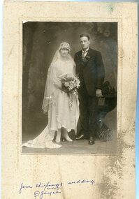 Orbost & District Historical Society
black and white photograph, July 1922
Jean Stirling , born 1901 in Orbost, married Charles Frances Reginald Joyes on 15th July 1922 in Orbost. Jean's father was John Stirling, son of James Stirling and Ann Gray. Her mother was Robina Harvey McNair, Aged 19 James Stirling arrived in Melbourne on January 26, 1842 with his family - parents, three sisters and two brothers. James Stirling moved around a lot to Whittlesea, Ballarat goldfields, Cunninghame, (now Lakes Entrance), then to the Old Station about 36 miles to the east along the coast near the mouth of the Snowy River and for a time settled there with his wife also from Wigton, Scotland, and their family four sons two daughters (James, John, William, George, Margaret and Polly). The first settler to occupy the Marlo township area was James Stirling around the year 1875. He built a bark hut on the bluff that had two rooms, bark walls, earthen floors and a shingle roof. By 1884, this structure had expanded to a 9 roomed accommodation house and in 1886 became the Marlo Hotel when a liquor license was granted. (more information from “Snowy River Mail”, Wednesday, April 13th 1977: MEMORIES OF MARLO by Mrs Elsbeth Conlon (nee Stirling )This photograph is associated with the Stirling family early settlers of Marlo. It is also a pictorial record of styles of wedding dress popular in the 1920s.A black / white studio portrait / photograph of a bridal couple. The bride on the left is wearing a typical 1920s wedding dress. tTe front is short with a hem that is in different length in front than behind. She is wearing a hat in the cloche-style. She is holding a bouquet of flowers and her train is draped to the left. The groom is wearing a three piece morning suit. he has a with a wingtip collar white dress shirt and a cravat tie.on front - hand - written "Jean Stirling's wedding (Marlo) ? Joyce"stirling-jean-wedding melba-&co wedding-clothing-1920s joyes-charles-francis-reginald -
 Orbost & District Historical Society
black and white photographs, 1980s? (winter months)
All photographs seem to have been takenfrom the Telecom tower on the corner of Browning and Wolseley Streets in Orbost 3259.1 is a view of the Orbost township looking north-east. The swimming pool and bowling club can be seen in the foreground. 3259.2 is aview looking north-west and showing the tennis courts and clubhouse, the Recreation Reserve oval, the Youth Centre, Historical Museum, Municipal Offices, Senior Citizens clubrooms with the fire station in the foreground. 3259.3 is a view looking south with the Shire of Orbost Municipal offices and Ruskin Street in the foreground. Munro Street can be seen running from Ruskin Street to St Joseph's School in the middle distance. Lochiel Park oval, Lochiel House, the Snowy River and highway bridge are in the background. 3259.4 is a view looking south showing the Club Hotel, C.B.C. Bank in the middle distance and Hoffman's paddock (Forest Park) and the Snowy River beyond. 3259.5 is a view looking north-east over houses. 3259.6 is aview over the main street, Nicholson Street.showing the main shopping precinct. Shop signs for Permewans, Williams Shoes, F.B. Dicken and Orbost Bakery can be seen. 3259.7 is a view looking south west and shows Forest park and beyond towards Bete Bolong.These photographs are detailed pictorial records of the township of Orbost.Seven black / white photographs taken from above a township. Chimney smoke can be seen in the photographs.orbost-township-1980s aerial-photograph-orbost -
 Ringwood and District Historical Society
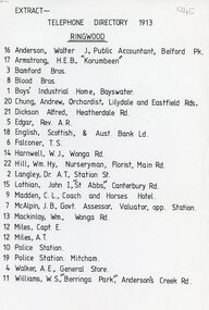
Document, 1913 Ringwood Telephone Directory
One A4 sheetTELEPHONE DIRECTORY 1913 RINGWOOD 16 Anderson, Walter J, Public Accountant, Belford Pk. 17 Armstrong, H.E.B., 'Korumbeen'' 3 Bamford Bros. 8 Blood Bros. 1 Boys' Industrial Home, Bayswater. 20 Chung, Andrew, Orchardist, Lilydale and Eastfield Rds, 21 Dickson Alfred, Heatherdale Rd. 5 Edgar, Rev. A.R. 18 English. Scottish, & Aust. Bank Ld. 6 Falconer, T. S. 14 Harnwell, W.J., Wonga Rd. 22 Hill, Wm.Hy, Nurseryman, Florist, Main Rd. 2 Langley, Or A.T. Station St. 15 Lothian, John I, "St Abbs" Canterbury Rd. 9 Madden, C. L., Coach and Horses Hotel. 7 McAlpin, J. B., Govt. Assessor, Valuator, opp. Station. 13 Mackinlay, Wm., Wonga Rd. 12 Miles, Capt. E. 12 Miles, A.T. 10 Police Station. 19 Police Station. Mitcham. 4 Walker, A.E., General Store. 11 Williams, W.S., 'Berringa Park,' Andersons Creek Rd. -
 Ringwood and District Historical Society
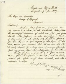
Letter, Letter from N Madden to Mayor and Councillors , Borough of Ringwood. 1937
Hand written letterLetter is from N.Madden -Coach and Horses Hotel, to the Ringwood Borough Council, dated 9th June 1937. Contents regarding Allotments of land in the Heatherdale Station Estate. -
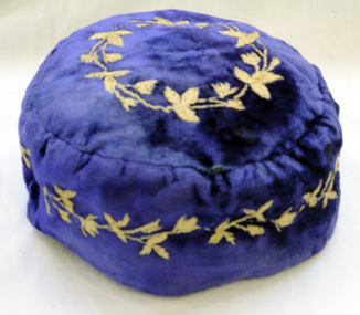 Orbost & District Historical Society
smoking cap, late 19th century
Smoking Caps are caps worn by men while smoking to stop the hair from smelling of smoke. They also kept the head warm. They were popular in the period 1840-1880, usually worn by gentlemen in the privacy of their home. This beautiful velvet smoking cap was worn by James Stirling who was the first settler to occupy land in the Marlo township. James stirling arrived in Victoria from Scotland in 1842.He took over Corringle Station (Ewing's Marsh). His son James stirling later established theMarlo Hotel. (Read more in Mary Gilbert’s book)Smoking accessories like this cap were popular through the mid-to-late nineteenth century to prevent the smoker's hair from absorbing the smell of tobacco smoke and were often worn with smoking jackets. The design, with its elaborate embroidery shows an aspect of Victorian material culture and reflects the nineteenth-century love of 'Oriental' style. . A domed shaped smoking cap of blue velvet .It is lined with silk. The tops and sides are embroidered with tan coloured leaves. head-coverings stirling-james smoking-cap -
 Ringwood and District Historical Society
Photograph, Photos from a Weekly Times newspaper article featuring images of early Ringwood and East Ringwood circa 1910 (6 photos), Circa 1910
Shops, houses and hotel(s) were originally regarded as being in central Ringwood and later as Ringwood East after the commercial and residential developments gradually centered further west around the Railway Station precinct after train services commencedFive photographs; Ringwood Railway Crossing; Ringwood Shopping Strip; Pruning Demonstration; Shops, houses and hotel(s) in Mount Dandenong Road; Ploughing.Written on backing sheet, "Photos from Weekly Times. Check with H.A." -
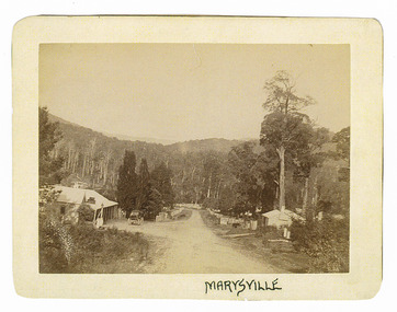
 Marysville & District Historical Society
Photograph (Item) - Black and white photograph, Fernshaw, c1900
An early black and white photograph taken at Fernshaw.An early black and white photograph taken at Fernshaw. Fernshaw was a rural township 63 km north-east of Melbourne and 10 km north-east of Healesville. Situated on the Watts River, near where a log had fallen making a convenient crossing, Fernshaw was settled in the 1860s. It provided good country for orchards and berry growing. The location was at the foot of Blacks Spur, with Mounts Juliet and Mondah rising on either side, providing spectacular scenery. There were nearby fern gullies giving rise to the name – ‘shaw’ is old English for thicket or wood. By 1875 Fernshaw had a post office (1865), two hotels, a school (1871) and stores. It was famed for its beauty, attracting tourists. In 1886 the Melbourne and Metropolitan Board of Works began work on the Watts River water catchment scheme – later to become Maroondah – and the Board obtained approval for the catchment country to be reserved and kept free of settlement. This required the removal of the Fernshaw township, which was completed by about 1890. The area was described in the 1903 Australian handbook:ARMSTRONG COLLECTION 42 STATION STREET/ SANDRINGHAM 3191/ TEL. (03) 9521 5442/ IAN M.L. ARMSTRONG OAMfernshaw, healesville, watts river, orchard, berry orchard, blacks spur, black spur, mount juliet, mount mondah, maroondah dam, victoria -
 Marysville & District Historical Society
Photograph (Item) - Black and white photograph, Marysville, c1900
An early black and white photograph of the main road in Marysville in Victoria showing the Keppels Australian Hotel.An early black and white photograph of the main road in Marysville in Victoria showing the Keppels Australian Hotel which was built and opened by the Keppel Family in 1865. The Keppels Australian Hotel was the first hotel to be opened in Marysville. The Keppel Family were among Marysville's earliest pioneering families.ARMSTRONG COLLECTION 42 STATION STREET/ SANDRINGHAM 3191/ TEL. (03) 9521 5442/ IAN M.L. ARMSTRONG OAMaustralian hotel, marysville, keppel family, maurice john keppel, keppels australian hotel, keppels hotel, victoria -
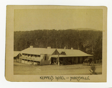 Marysville & District Historical Society
Photograph (Item) - Black and white photograph, Keppel's Hotel - Marysville, c1900
An early black and white photograph of the Keppels Australian Hotel in Marysville in Victoria.An early black and white photograph of the Keppels Australian Hotel which was built and opened by the Keppel Family in 1865. The Keppels Australian Hotel was the first hotel to be opened in Marysville. The Keppel Family were among Marysville's earliest pioneering families.ARMSTRONG COLLECTION 42 STATION STREET/ SANDRINGHAM 3191/ TEL. (03) 9521 5442/ IAN M.L. ARMSTRONG OAMkeppel hotel, keppels australian hotel, australian hotel, keppel family, maurice john keppel, marysville, victoria -
 Marysville & District Historical Society
Photograph (Item) - Black and white photograph, Yarra Track Hotel, c1900
An early black and white photograph of a hotel along the Yarra Track.An early black and white photograph of a hotel along the Yarra Track. The Yarra Track is the former name of the gold fields road from Healesville to the Woods Point and Jordan Goldfields, in Victoria, Australia. A direct route via the Yarra River and the Great Divide was discovered by Rieck in September 1862 and became known as the Yarra Track. Early in 1863, the Victorian Government decided to construct a 193-kilometre (120 mile) road along the route. Its original width varied between 4 and 6 metres (12 and 20 feet), and was designed to accommodate horse-drawn vehicles. The Track involved the climbing of the Black Spur, descent into the Acheron Valley, and then through Marysville to the Cumberland where it followed the existing route. Unable to ascertain both the location and name of hotel.ARMSTRONG COLLECTION 42 STATION STREET/ SANDRINGHAM 3191/ TEL. (03) 9521 5442/ IAN M.L. ARMSTRONG OAMyarra track, healesville, wood's point, jordan goldfields, victoria, yarra river, great divide, reick, black spur, acheron valley, marysville, cumberland creek -
 Marysville & District Historical Society
Photograph (Item) - Black and white photograph, The "Scandinavians' - (Deserted), c1900
An early black and white photograph of The Scandinavian's Hotel and Boarding House along the Yarra Track.An early black and white photograph of The Scandinavian's Hotel and Boarding House along the Yarra Track. The Yarra Track is the former name of the gold fields road from Healesville to the Woods Point and Jordan Goldfields, in Victoria, Australia. A direct route via the Yarra River and the Great Divide was discovered by Rieck in September 1862 and became known as the Yarra Track. Early in 1863, the Victorian Government decided to construct a 193-kilometre (120 mile) road along the route. Its original width varied between 4 and 6 metres (12 and 20 feet), and was designed to accommodate horse-drawn vehicles. The Track involved the climbing of the Black Spur, descent into the Acheron Valley, and then through Marysville to the Cumberland where it followed the existing route.ARMSTRONG COLLECTION 42 STATION STREET/ SANDRINGHAM 3191/ TEL. (03) 9521 5442/ IAN M.L. ARMSTRONG OAMthe scandinavians', yarra track, healesville, wood's point, jordan goldfields, victoria, yarra river, great divide, reick, black spur, acheron valley, marysville, cumberland creek -
 Marysville & District Historical Society
Photograph (Item) - Black and white photograph, Camp Opposite The "Scandinavians', c1900
An early black and white photograph of a camp which was opposite The Scandinavian's Hotel and Boarding House along the Yarra Track.An early black and white photograph of a camp which was opposite The Scandinavian's Hotel and Boarding House along the Yarra Track. The Yarra Track is the former name of the gold fields road from Healesville to the Woods Point and Jordan Goldfields, in Victoria, Australia. A direct route via the Yarra River and the Great Divide was discovered by Rieck in September 1862 and became known as the Yarra Track. Early in 1863, the Victorian Government decided to construct a 193-kilometre (120 mile) road along the route. Its original width varied between 4 and 6 metres (12 and 20 feet), and was designed to accommodate horse-drawn vehicles. The Track involved the climbing of the Black Spur, descent into the Acheron Valley, and then through Marysville to the Cumberland where it followed the existing route.ARMSTRONG COLLECTION 42 STATION STREET/ SANDRINGHAM 3191/ TEL. (03) 9521 5442/ IAN M.L. ARMSTRONG OAMthe scandinavians', yarra track, healesville, wood's point, jordan goldfields, victoria, yarra river, great divide, reick, black spur, acheron valley, marysville, cumberland creek -
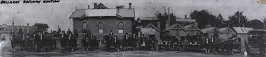 Federation University Historical Collection
Photograph, Darling & Co Carriers at Ballarat Railway Station
Offices of Darling and Co Carriers at north side of Ballarat Railway Station with teams of horses and wagons.ballarat railway station, signal box, horse teams, victoria house, w. w. chisham, darling & co general carriers, provincial hotel, chisolm general carrier -
 Glen Eira Historical Society
Document - LECHTE, WILLIAM LUDWIG SAMUEL SEBASTION
3 items about this person: 1/Two twelve page carbon copied documents, purportedly written by William Letchte, son of George, written in c1935/36. He writes of his jobs as a dairyman, cow minder at the age of ten tears. He recollects streets, people, residences, business and general landscape in the area, as he takes you on a tour of the area. 2/Photocopied photo of Katrina Lechte (nee Bolch?) donated by Ian Lechte, 15 Adrian Street, East Bentleigh. 3/Photocopied copy of first pages and cover of William Lechte’s booklet on ‘Caulfield 1869 – 1935 Memories of the Past’, published by the City of Caulfield, 1992. The Society has the full booklet in its book collection (not yet catalogued as of 07/07/2015).grange road, glenhuntly, glen huntly station, alma road, dairies, caulfield park, swamp, queens avenue, station street, cross street, racecourse, heywood j. g., turf club hotel, dandenong road, royal hotel, koornang road, north road, murrumbeena road, mclaurin archibald, crosbie j. w., poath road, newton mr., hooker mr., peck family robert farmer, dairies, ross murray, rosstown, hansen hans, arnott family, peppin family, ormond station, malane family, fraser simon, overtons, shepherds, spring road, mohlers, brighton cemetery, mall kim, market gardeners, long john farmer, fiedler mr., booran road, reservoir, summers mr., maddocks mr., holland mr., caulfield council, glen eira road, harriman benjamin c., kambrook road, bambra road, princess park, marriott john, hawthorn road, brickworks, hyam mr., cottages, jasmine street, sycamore street, paddy o’briens swamp, arnold tom, london tavern hotel, guess john-grocer, topp mr., poath road, pine trees, colonel le marehand, balaclava junction, chemist shop, bell mr., nicholls mr. william h., wine shop, orme mr., pepperorn mr. john, balaclava road, orchards, harvey mr. robert tailor, schubert mr., blew charlie – gardener, philpott mr. richard b., farquhar mr. william farmer, newing t. r., glen eira road, payne john, brockhoft mr., dickson mr. james, snipe t., bevan mr., mckean family john, murray family, francis mr., hart mr., mcdougall james, brady peter, cad, elsternwick station, webb mr., masters mr. samuel, master street, ford mr., anderson mr. joseph gardener, slaney mr., boxhill mr. richard, post office, newsagent, hotham street, service james, bunn mr., sargood mr., orrong road, arnold tom – dairy, officer mr., grimwade mr., alexandra street, oakleigh hall, degraves mr., wilson samuel, ‘manifold’, house names, miller septimus, alma road, knox mr. james gardener, smith mr., coachman, ‘cumloden’, lange mr., holyrood justice mr., cronin mrs. mary, mcgivenys dairy, ‘belle vista’, lloyd c. d., caulfield council, hughes mr., armstrong j. a., tom healey’s market garden, kooyong road, inkerman road, tom roe’s market garden, mcleod captain, daish captain, plumridger mr. frederick, gardeners, tester mr. thomas, kent mr., kent g., fiddes mr., billings mr., semple mr., fosberry mr., howitt or., merrett mr., orchards, hawthorn road, hines mr., ‘rosecraddock’, langdon h. j., ‘crotonhurst’, webb justice mr., renwick s., ‘garrell’, barry mr., drinsdale family, st. mary’s church, sunday school, newing miss, teachers, stephen justice mr., stephen wilberforce, mount l., grimwade’s, ‘grimwade house’, danby’s, spence mr., venables family, mr. moss’ congregational church, barnhill mrs., porter miss, webb’s, ferguson, orange, police stations, kooyong road, pennington mr., health inspectors, engineers, inkley mr., farriers, mckeon mr., ‘sylverly’, dixon mr. edward, turner mr., marriott robert, ‘ravenhurst’, thompson j. j., wott t., architects, perrin mr. francis, tennis courts, royal parade, sayce mr. joseph j. p., ricketson h., ‘glen eira’, mansions, hospitals, turner mr., evans family, stephens miss, registers, mcculloch lady, convalescent homes, prentice street, edward street, strickland, keany pat, brentwood charlie, fordham lewis, hopetoun gardens, higgins mr. joseph f. engineer, railway construction bill, evans mr., beavis mr., twycross family john, medina captain, cowderoy mr. benjamin, murray mr., moore mr., ‘glenfern’, st. georges road, glen huntly road, cedar street, hunt bill – ‘bandy hunt’, jessamine street, alder street, le page’s store, post offices, balaclava junction, stephens frank, solicitors, parkside street, robinson j., ilbery mr. and family, mclennan mrs., victoria street, savings bank, riddell parade, elworthy mr. richard, butchers, shaw mr. william, armstrong mr., guess’ hotel, sycamore street, bagshaw mr., clack joe, wawn alex, sisson family, north road, younger mr., kooyong road, sheridan joseph, anketell family – john, wren john – carpenter, wills mr. peter, attrills arnold, heffernan family, cox peter, ilbery john, hotham street, glen huntly road, page j. w., bakeries, forests, godfrey mr., blacksmiths, thompson j. j., olive street, cedar street, letchte w., tierney richard, alma road, st. kilda east, murray peter, letchte’ cows – grazing, holland grove, eskdale road, lechte katrina, lechte ian, lechte catherine, lechte warren, lechte stuart, lechte elaine -
Glen Eira Historical Society
Document - Racing Stables In Caulfield
... Tree Hotel Petrol Stations Veterinarian Clinic Norman Myers ...This file contains 3 items. 1/ Document provided by Veterinarian Dr G. G. Heslop about racing stables in the Caulfield area adjacent to the Caulfield Race Course, in both typed and handwritten form. 2/ A letter of request from a Sydney based sports writer Geoff Armstrong for information about the attempted shooting for Phar Lap. 3/ A letter to the Editor in the Glen Eira/Port Phillip Leader dated 02/04/2013 about the proposal to ban horse training from the Caulfield Racecourse.clubs and associations, victorian amateur turf club, racecourses, caulfield race course, racecourse trainers, stables, racehorses, schools, secondary school, caulfield high school, hotels, caulfield club hotel, wattle tree hotel, petrol stations, veterinarian clinic, norman myers veterinarian hospital, baker norma, bence j., bird j., cadby lou, conaghan basil, cameron ron, couseng harry, cox cecil, creighton norman, delaney g., eules darce, farmer h. (dick), fraser mick, foulsham fred, fryer j., gatell harry, garton a. (rod), garland f., godby cecil, godby frank, goodfellow claude, guinane p., hayes t. j., hilton h., hodgkinson george, james jack, jenkins e. j., jennings reg, judd des, jury jack, king frank, mcgregor j. n., mcnamara dave, mcphee sonny, mclaughlin, mulcahy j., murphy geoff, muskett j., parkinson j., phillipson mr., quinlan pat, ralph stan, reid stanley, robinson f., rolfe w. j., sanderson chris, telford w., tie jerry, torr harry, bernborough, black caviar, garryowen, phar lap, purser, revenue, spearfelt, surround, arthur jr., murrel violet, farmer violet, kemball w. r., mcdonald leslie, brockhoff mr., carslake mr., gullifer h., heywood j. g., llord mr., davies mr., palfreman mr., caulfield, caulfield north, caulfield south, carnegie, glen huntly, glenhuntly, eskdale road, balaclava road, bambra road, glen eira road, heywood street, hudson street, hawthorn road, kambrook road, kooyong road, tudor court, lloyds paddock, payne street, park crescent, service street, slaney’s paddock, station street, booran road, ‘moidart’, cadby court, glen huntly road, glenhuntly road, neerim road, ‘cintra’, stephen street, uranda line grove, willgra road, epsom street, lloyds street, lord street, queens avenue, st vincents street, roseberry grove, manchester grove, safeway supermarket, hesop g. g. dr veterinary surgeon -
Glen Eira Historical Society
Letter - Rosstown Railway
This file contains four items: 1/A black and white photocopy of a letter dated either 07/08/1889 or 09/08/1889, from Robert Lundon to an unidentified recipient discussing an agreement reached between the author – on behalf of the recipient – and Soon Hang Hi in regard, in regards to the allotment known as Webber’s. The agreement is outlined in the letter in what appears to be Chinese characters, and includes the marks of Robert Lundon and Soon Hang Hi. File note from Joy Wu states that the calligraphy is not Mandarin or traditional Chinese. 2/Three sheets of hand-written working notes with information taken from the Victorian Government Gazette on THE ROSSTOWN AND MURRUMBEENA LAND COMPANY LIMITED, THE ROSSTOWN JUNCTION RAILWAY AND PROSPERITY COMPANY LIOMITED, and THE ROSSTOWN JUNCTION, ELSTERNWICK, AND OAKLEIGH RAILWAY COMPANY LIMITED, covering dates between 1887 and 1894. The notes concern meetings and creditors claims relevant to the companies, with reference numbers for the information source. Date and author of the notes are not recorded. 3/A black and white photocopy of the a partial map of the Rosstown Railway and surrounding area, undated. The map includes the names of landholders in the areas of Brighton, Garden Vale and Elsternwick, as well as other railway lines present in the region. 4/A fold-out map and guide of the Rosstown Rail Trail, including a brief general history of Caulfield as well as a more extensive biography of William Murray Ross and the Rosstown Railway. The map marks and describes significant sites along the trail, including photographs of some of these sites, provided by DF Jowett.documents, correspondence, webber’s, lundon robert, chinese characters, ethnic communities, signatures, text, settlements, taxes, fraser john grieves, lovell r.h., price davies, meetings, communication activities, soon hang hi, commercial events and activities, the rosstown and murrumbeena land company limited, victorian government gazette, bulmer richard, parry john, osment henry, shareholders, creditors claims, the rosstown junction railway and property company limited, finch and best, lawyers, the rosstown junction elsternwick and oakleigh railway company limited, cameron w.c., phillips p.d., garden vale, elsternwick, elsternwick railway station, rosstown, rosstown railway, thomas street, bay street, kooyong road, melbourne and brighton railway, hawthorn road, bambra road, caulfield and frankston railway, booran road, grange road, koornang road, murrumbeena road, north road, north road railway station, east brighton railway station, south road, railway routes, railway lines, railways, land transport, murphy j., caulfield, hamilton t.f., dane p., holloway, webb, ailee john, payne t.b., brodie chas, dane john, o’neil h., mccombie john, mcmillane a., smyth c.d., cooper, ebden, landholders, jeffrey j.d., gill j., balcombe a.e., cooper h., mcnab j., white j., sutherland j., greeves a.f.a., newton m.c., chamley f.b., fowler j., inglis p., grant t., stooke j., swanson g., cochrane c., adams e.b., mccombie thas, keyes robert, brighton cemetery, burials grounds and graveyards, war-ein road, were j.b., holland j., mcmahon c., winter t.l.m., dendy henry, mitchell w., jackson s., were j.e., wickham francis dawe, bryant jane, east brighton railway station, railway stations, maps, allotments, land titles, roads and streets, rosstown rail trail, city of glen eira, tourism, trains, tourism information bureaus, tours, pamphlets, elsternwick railway park, oakleigh junction, princes park, ee gunn reserve, packer park, sites, jowett d.f., weickhardt i.g., return to rosstown: railways land sales and sugar beet ventures in caulfield, land sales, walking trails, ross william murray, transport objects, locomotion, walking, cycling, driving, sports, country mansions, people, caulfield john, builders, construction and demolition workers, occupations, careers, professionals, topography, geology, landforms, horticulture, market gardens, primary industry workers, city of caulfield, mood kee, pennington harold, annual general meetings, caulfield town hall, glen eira city council, carnegie, carnegie station, rosstown station, people by circumstance, migrants, sugar beet, sugar beet mill, sugar beet industry, mills, factories, sea beach lines, bent thomas, parliamentary representatives, neville street, miller street, lemann’s swamp reserve, koornang park, cane sugar industry, breweries, rabbit processing plants, health establishments, hospitals, food production establishments, abattoirs, thieves, social problems, vagrants, theft, squatting, financial economics, debt, finance industry, insurance companies, company managers, bentleigh, ross leila, the grange, leila road, wild cherry road, financial trouble, mortgages, gisborne street, archibald street, riddell parade, victoria railways, glen huntly road, clarence street, college street, gladstone parade, parrell street, aileen avenue, seaview street, drion estate, land subdivisions, dover street, sussex street, landfill, marara road, booran road, woodville avenue, dorothy avenue, ormond park, royal avenue, ormond railway station, oakleigh road, melten avenue, miller street, munro avenue, lord reserve, neerim road, toolambool road, the rosstown hotel, rosanna street, murrumbeena crescent, commercial establishments, the national bank, rosstown road, kangaroo road, poath road, freda street, hughesdale kindergarten, oakleigh council, hughesdale community centre, civic establishments, galbally reserve, plaques, warrigal road, out and about brochures