Showing 1548 items matching "streetscapes"
-
 Buninyong & District Historical Society
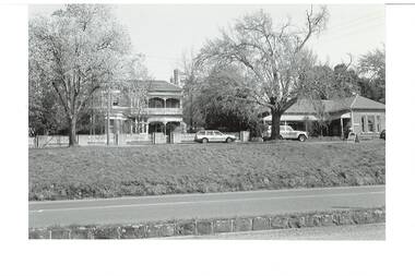
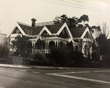
Photograph - B/W photograph, Dr Longden's and Sparling's former residences, Learmonth St west, Buninyong, July 1993
Dr Longden, a medical practitioner, was a significant figure in Buninyong history in the late 1800s.Brick buildings are prominent examples of Victorian era residences. Dr Longden was a prominent medical practitioner in Buninyong in the late 1800s.B/W photo of Dr Longden's (built circa 1898) and Sparling's former residences, Learmonth St west, Buninyong. Streetscape photo taken in 1993 of two brick residences.buninyong, longden, sparling, brick building, house, street scape, learmonth st -
 Sunbury Family History and Heritage Society Inc.
Photograph, Royal Hotel
The two storey building in the photograph is the Royal Hotel. The original single storey hotel was damaged by fire in the 1930s so the double storey red brick building replaced it on the same site, which is at the intersection of Evans and Brook Streets. For many years the MIllett family owned and ran the hotelThe Royal Hotel is one of four hotels that operated in Evans Street between Station and Brook Streets. Only two of those hotels are operating on their original sites. The other two have been demolished and replaced with retail businesses.An enlarged black and white non-digital photograph with a narrow cream border of a streetscape of an intersection with a two storey brick building on one corner and cars park by the kerb outside the building.royal hotel, millett family, evans street, brook street, hotels -
 Canterbury History Group
Ephemera - 6 Logan Street Canterbury, {2007}
Real estate advertisement for the sale of "Raasay" c1903 6 Logan Street Canterbury on Saturday 26 August {2007} by Kay & Burton. Includes coloured photographs of the interior, exterior and streetscapecanterbury, logan street, queen anne style, fountains, raasay -
 Buninyong & District Historical Society
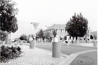
Photograph - Original B/W Photograph, Roundabout - intersection of Learmonth and Warrenheip Streets Buninyong. Background RSL Hall and Memorial Gardens, Masonic Hall, September 1993
Showing streetscape in the late 1990s. Roundabout construction started in 1987Showing streetscape in the late 1990s.Black and white photograph of roundabout at intersection of Learmonth and Warrenheip Streets Buninyong. Background RSL Hall and Memorial gardens and Gates, Masonic Centrestreetscape, buninyong, rsl memorial gardens, rsl hall, masonic centre -
Tatura Irrigation & Wartime Camps Museum
Booklet, Nagambie Anniversary Book
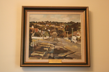
Artist's impression of Nagambie's Historical streetscape and bridges over past years.Cream cover, green writing. Sketch of buildings in main street, Nagambie.nagambie tourism inc, books, history, local, nagambie streetscape, nagambie bridges -
 Bendigo Historical Society Inc.
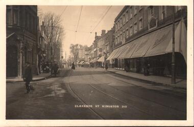
Postcard - BASIL WATSON COLLECTION: CLARENCE ST KINGSTON 219
black and white postcard, image shows streetscape, buildings with awnings, tramway on side of road. Written on bottom 'Clarence St Kingston 219' . Woman in long dress in distance, man in foreground.place, streetscape, clarence street, kingston, uk -
 Whitehorse Historical Society Inc.
Photograph, Decorations for Visit of Queen Elizabeth, Mitcham, 1954, 1954
Black and white photo of Decorations for Visit of Queen Elizabeth, Mitcham, 1954. Note position of monument located in position two. Appearance of Mitcham streetscape static - unchanged since pre-war.royal tour 1954, queen elizabeth ii -
 Hume City Civic Collection
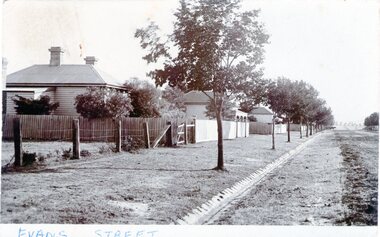
Photograph - Evans Street, Sunbury, c1880 - 1900s
The photograph shows a picture of Evans Street Sunbury taken from the T intersection at Macedon Street and looking south. When the photograph was taken it was one of Sunbury's main residential areas. Since the 1980s the houses in the image have been demolished and replaced with commercial development.- Over the years Evans Street has undergone much change from being a residential strip to being the main commercial hub in Sunbury.– An enlarged photograph of a streetscape with a row of trees growing along the footpath and a number of weatherboard Victorian style double fronted cottages. Both the roadway and footpath are not surfaced and the gutter is lined with stone pavers.sunbury -
Canterbury History Group
Ephemera - Canterbury, 197 Canterbury Road. Mind your own business here, 1/05/2003 12:00:00 AM
Real estate advertisement for the sale by auction of shop in Canterbury Buildings, 197 Canterbury Road, on Thursday 15 May 2003. Includes a coloured photograph of the exterior of the shop and a streetscape, and floor plan.canterbury, canterbury road, shops, victorian style, canterbury buildings -
 Geoffrey Kaye Museum of Anaesthetic History
Painting, Harry Sherwin, Delivery Van Katoomba
A small oil painting set in an ornate gold-gilded frame with a small brass plaque detailing donor information. The painting depicts a Katoomba urban streetscape featuring a parked delivery van.Inscription on the brass plaque. "DELIVERY VAN KATOOMBA / By HARRY SHERWIN / Presented by Douglas Joseph Dean 1980–1982"art, artwork, painting, streetscape, urban art, urban sketching -
 Kew Historical Society Inc
Photograph, Stewart West, Junction of High Street and Cotham Road, Kew, 2001, 2001
Photograph taken by Stuart West for an exhibit comparing past and present streetscapes in KewColour photograph by Stuart West of the junction of High Street and Cotham Road, Kew. The photo was shot in 2001. It shows the Kew War Memorial, former Post Office and Court House.kew post office, cotham road (kew), high steet (kew) -
 Port Melbourne Historical & Preservation Society
Photograph - Market shop demolition
Market buildings established 1885. Demolition retained streetscape but allowed new businesses .Colour photo showing Market shop demolition in Bay St 1989. Old frontage retained. Nott St homes and Council flats visible in backgroundbuilt environment - demolition, built environment - commercial, built environment - civic -
Clunes Museum
Book, WESTON ARTHUR BATE, LUCKY CITY - THE FIRST GENERATION AT BALLARAT: 1851 - 1901
IN 1854, ATTRACTED TO THE AREA BY WORLD FAMOUS GOLD DISCOVERIES, A EUROPEAN ARTIST SKETCHED AND ABORIGINAL AT WORK I THE FOREST AT WARRENHEIP NEAR BALLARAT...GREEN FABRIC COVER WITH GOLD LETTERING ON SPINE, COMPLETE WITH DUST COVER WHICH DISPLAYS A COLOURED ENGRAVING OF NINE PEOPLE IN A LANDSCAPE OF HILLS AND STREETSCAPE IN THE DISTANCE (AN ILLUSTRATION OF BALLARAT FROM BLACK HILL) non-fictionIN 1854, ATTRACTED TO THE AREA BY WORLD FAMOUS GOLD DISCOVERIES, A EUROPEAN ARTIST SKETCHED AND ABORIGINAL AT WORK I THE FOREST AT WARRENHEIP NEAR BALLARAT...the first generation of ballarat 1851-1901, gold fields of central victoria -
 Charlton Golden Grains Museum Inc
Photograph, Charlton Shire, Charlton Motel c. 1987, c.1987
The motel was built in the 1960s. Photo is part of a Charlton Shire streetscape series c.1987.Colour photograph of the Charlton Motel taken looking south east. The Motel is a white brick, single-storey building with a red trimmed roof. The verandah and some front windows are arches. There is a large garden bed with shrubs in front of the verandah. On the left are signs for various community organisations - Lions, Rotary, Apex, Young Farmers, Red Cross, and Amity. A cream coloured car is parked in the drive way business, charlton, motel -
 Eltham District Historical Society Inc
Photograph, Peter Pidgeon, Nyora Road, Eltham, 21 Sep 2017, 21 September 2017
Streetscape changes - looking at Bapbtist Church, former Eltham Christian School and trees being removedBorn Digitaleltham, nyora road -
 Eltham District Historical Society Inc
Photograph, Peter Pidgeon, Nyora Road, Eltham, 21 Sep 2017, 21 September 2017
Streetscape changes - looking at Bapbtist Church, former Eltham Christian School and trees being removedBorn Digitaleltham, nyora road -
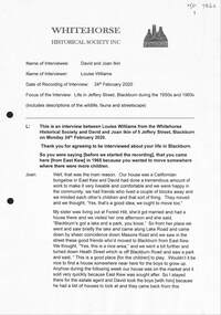 Whitehorse Historical Society Inc.
Document - Interview Transcript, Williams, Louise, David and Joan Ikin, 24/02/2020
A transcript of an interview with David and Joan Ikin of 5 Jeffery Street, Blackburn on the 24 February 2020. the interview was conducted by Louise Williams of WHS. It includes descriptions of wildlife, fauna and streetscapes from 1965 onwards.A transcript of an interview with David and Joan Ikin of 5 Jeffery Street, Blackburn on the 24 February 2020. The interview was conducted by Louise Williams of WHS. It includes descriptions of wildlife, fauna and streetscapes from 1965 onwards.non-fictionA transcript of an interview with David and Joan Ikin of 5 Jeffery Street, Blackburn on the 24 February 2020. the interview was conducted by Louise Williams of WHS. It includes descriptions of wildlife, fauna and streetscapes from 1965 onwards.williams louise, savage janet, ikin david and joan, satchwell, jeffery street blackburn, clayton ann, huntsman keith, huntsman robin, blackburn lake -
 Greensborough Historical Society
Photograph - Photographs, Rosie Bray, Streetscape at Watsonia shops, 2005
Photographs of the streetscape at Watsonia shopping centre, includes Andres Supermarket, and a seating area and roadway undergoing refurbishment.3 colour photographswatsonia shopping centre, watsonia road watsonia -
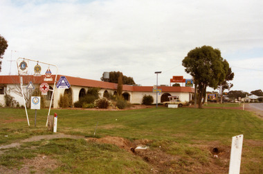
 Buninyong & District Historical Society
Photograph - Colour photograph of new building in Warrenheip Street, New building in Warrenheip Street 1996
Several new buildings being built replacing old cottage in Warrenheip Street altering the old streetscape.This image illustrates late twentieth century development of the the old streetscape of Buninyong replacing one cottage on a typical housing block with multiple townhouses. A colour photograph of new building replacing cottage in Warrenheip Street Buninyong February 1996Warrenheip Street, Buninyongstreetscape, warrenheip street -
 Kew Historical Society Inc
Photograph, City of Kew, 878 Glenferrie Road, Kew, c.1980
... streetscapes ...One of a series of photos created for an exhibition by the City of Kew of notable locations. The photos represent a snapshot in time.Enlarged photograph of 878 Glenferrie Road, Kew, mounted on board, and donated to the Kew Historical Society by the City of Kew on 10 April 1991. The house was extant when checked in August 2017.From Kew City C'cil 10 April 1991878 glenferrie road - kew, streetscapes -
 Ararat & District Historical Society (operating the Langi Morgala Museum)
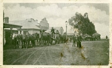
Photograph, Willaura Weighbridge
This photograph shows a point in time (late 19C) at the Willaura weighbridge which no longer exists. The weighbridge was part of a transportation system that included horses, wagons, silos, and trains and when this photograph was taken, the weighbridge was crowded with people and wagons. Black and white photograph of a streetscape with wide dirt roads, some early European buildings and three supply wagons. Two are horse drawn and the third is pulled by bullock, with six men driving the wagons and standing in the roadway. Front: "Willaura Weighbridge"willaura, weighbridge, postcard, horses, wagons, wool, transport -
 Ringwood and District Historical Society
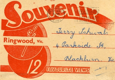
Souvenir - Folder, Samuel Lee and Co, 12 Black and White Souvenir photos of Ringwood, 1975, 1957
Souvenir photos sent to Terry Schwab in 1957 from Mick who hoped he would have many memories of Ringwood. Donated to the Society by Terry.Buff coloured folder with red printing containing 12 black and white favourite photos of Ringwood. Streetscapes, buildings and Ringwood lake. 4 separated from rest. From Mick. +Additional Keywords: Schwab,Terry -
 Bendigo Historical Society Inc.
Photograph - JORDAN COLLECTION: COLOUR PHOTO OF STREETSCAPE IN BENDIGO, late 1970 - 1980's
Colour photo of a streetscape in Bendigo. Image shows spire of Cathedral in background, timber house on RH side, with large Norfolk pine beside. Appears to be approx late 1970's - through to mid 1980's.bendigo, streetscape, general street views -
 Bendigo Historical Society Inc.
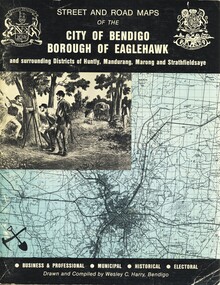
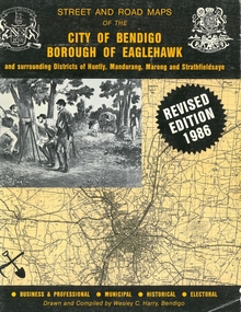
Book - STREET AND ROAD MAPS OF THE CITY OF BENDIGO BOROUGH OF EAGLEHAWK, c1980
... streetscapes ...Street and Road Maps of the City of Bendigo Borough of Eaglehawk and surrounding Districts of Huntly, Mandurang, Marong and Strathfieldsaye, in color. Drawn and compiled by Wesley C Harry, Bendigo. Publisher: Cambridge Press, Bendigo. ISBN: 9598608.2.2. 68 pages. Photographs, Illustrations & maps. Photos include: Bendigo buildings, scenery mines, streetscapes, parades, pioneer leaders of Bendigo. Many advertisements throughout. List of Justices of the Peace, hospitals, homes for the aged, schools, churches. Page 58: Copy of ''Freedom of the City to the Australian Survey Regiment'' proclamation, 14th June 1970. Maps cover an area of some 169 sq. miles (43,772 hectares). Origin of the name Bendigo. Information on the five Wards of Bendigo, and their councilors.Wesley C Harrybook, bendigo, bendigo & district maps, bendigo and districts map, buildings, streetscapes, historical pictures, advertisements, historical information, commisioners camp, sandhurst -
 Beaufort Historical Society
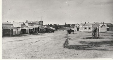
Photograph - Beaufort Streetscape, Neil Street, c. 1870
Beaufort hotel beaufort streetscape. Shows location of old Beaufort Hotel, Weighbridge and site of current Band Rotunda.Black and white photo of Beaufort circa 1870 looking east including Beaufort Hotel, dirt road, horse and cart and early buildings.streetscape, beaufort, hotel, band rotunda, weighbridge -
 Orbost & District Historical Society
coloured photographs, 1948 1954 ?
These photographs were probably taken in the late 1940s - mid 1950s. 3275.1 was taken at the roundabout in Nicholson Street / Salisbury Street intersection looking south. On the right is the The Commonwealth Hotel and the Gippsland Northern Store can be seen on the right. The war memorial can be seen in the centre of the intersection. 3275.2 has been taken from a height (possibly from behind the hardware store) overlooking Orbost House in McLeod Street. The butter factory can be seen in the background. Back yard toilets and paling fences can be seen with a narrow lane for the sanitary truck. Mrs Ruth Hannah Macalister, 1861-1932, established “Orbost House” as a boarding house in about 1900. Following her demise “Orbost House” was taken over by her son, “Reg” and his wife and they continued the Macalister family‟s association until the accommodation house was purchased by “Slim” and Eileen Somerville and Lindsay and Joan Jensen, in partnership, in 1963. (info. from Marilyn Morgan)These photographs are detailed pictorial records of Orbost in the mid 20th century. They show the objects in their spatial context with detail.Two coloured photographs. 3275.1 is a streetscape with a large hotel on the right, a main shopping area in the background and a wooden fence on the left. 3275,2 is overlooking backyards and fences. In the middle is an extensive red roof with "ORBOST HOUSE" in white print.on back - 1948-1954orbost-1950s orbost-house commonwealth-hotel -
 Bendigo Historical Society Inc.
Photograph
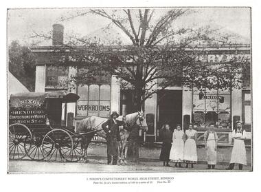
Photograph: Streetscape showing confectionary works (workrooms) in background with horse drawn wagon and 3 staff, 3 women and 3 men on road edge Wagon signed with: ''J Nixon Bendigo Confectionery Works High St''photograph, landscape, confectonary, horse drawn wagon, confectionary, j nixon -
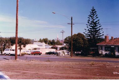
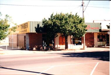 Hume City Civic Collection
Photograph, Early 1990's
The building suppliers and timber yard has been demolished and a Centrelink Office and car park area has been built on the site. The adjacent shop is now a Youth Resource Centre.A coloured photograph of part of a streetscape on the east side of Evans Street featuring the timber supply yard and 3 other shops. A plane tree has been planted at the edge of the footpath and there are high cyclone gates into the timber yard.building suppliers, timber yards, shopping centres, evans street, george evans collection -
 Bendigo Historical Society Inc.
Book - STREET AND ROAD MAPS OF THE CITY OF BENDIGO BOROUGH OF EAGLEHAWK, c1980
... streetscapes ...Street and Road Maps of the City of Bendigo Borough of Eaglehawk and surrounding Districts of Huntly, Mandurang, Marong and Strathfieldsaye, in color. Drawn and compiled by Wesley C Harry, Bendigo. Publisher: Cambridge Press, Bendigo. ISBN: 9598608.2.2. 68 pages. Photographs, Illustrations & maps. Photos include: Bendigo buildings, scenery mines, streetscapes, parades, pioneer leaders of Bendigo. Many advertisements throughout. List of Justices of the Peace, hospitals, homes for the aged, schools, churches. Page 58: Copy of ''Freedom of the City to the Australian Survey Regiment'' proclamation, 14th June 1970. Maps cover an area of some 169 sq. miles (43,772 hectares). Origin of the name Bendigo. Information on the five Wards of Bendigo, and their councilors. Revised Edition 1986Wesley C Harrybook, bendigo, bendigo & district maps, bendigo and districts map, buildings, streetscapes, historical pictures, advertisements, historical information, commisioners camp, sandhurst -
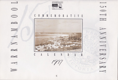 Warrnambool and District Historical Society Inc.
Souvenir - Warrnambool 150th Anniversary Commemorative Calendar, 1997, 1997
This calendar is a memento of the 150th anniversary of the settlement of Warrnambool. It has a range of photographs which depict buildings and streetscapes over that time.Gives a good coverage of history in Warrnambool from 1847 to 1997150th Anniversary Calendar. 20 pages with historic photos throughout, with detailed description of all. Black print, sepia photos warrnambool, warrnambool 150th anniversary, commemorative calendar, warrnambool photographs