Showing 1820 items
matching subdivisions
-
 Kew Historical Society Inc
Plan - Subdivision Plan, Balwyn Theatre and Shop Sites, circa 1927-28, c.1927-28
The Kew Historical Society's map collection includes a substantial number of real estate subdivision plans, mainly of Kew but also of surrounding suburbs in Melbourne. Most of the subdivision plans date from the 1920s and 1930s when the districts old homes and local farmland were being split up to accommodate residential growth in the postwar period. These early plans were assembled by a local firm, Jas R Mather & McMillan, which had an office in Cotham Road. Many of the plans, and sometimes photos, were annotated by the agents. The ‘new’ Balwyn Picture Theatre was built and owned by Balwyn Theatres Pty Ltd in ca. 1928. By 1930, this first Balwyn Theatre was destroyed by fire after a break-in. Following the fire, a new cinema was constructed. This plan for a Cinema and eleven shops presumably dates from 1927/28 when the Company announced that this location in Whitehorse Road ‘was the most central and best suited [area] for their Theatre and shops’.Subdivision plans are historically important documents used as evidence for the growth of suburbs in Australia. They frequently provide information about when the land was sold as well as evidence relating to surveyors and real estate and financial agents. The numerous subdivision plans in the Kew Historical Society's collection represent working documents, ranging from the initial sketches made in planning a subdivision to printed plans on which auctioneers or agents listed the prices for which individual lots were sold. In a number of cases, the reverse of a subdivision plan in the collection includes a photograph of a house that was also for sale by the agent. These photographs provide significant heritage information relating house design and decoration, fencing and household gardens.The photograph may also be aesthetically significant depending on the importance of the photographic atelier.Subdivision plan showing the Balwyn Theatre and its adjoining shop sites in Whitehorse Road Balwyn. The 11 shop sites were noted for their depth (133 ft - 145 ft. [Map.0041]balwyn theatre -- balwyn (vic.), subdivisions -- balwyn (vic), subdivision plans -
 Ringwood and District Historical Society
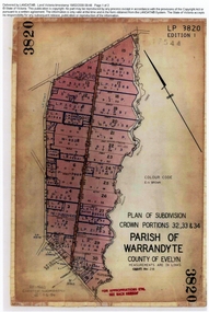
Document, Titles of land subdivision, Crown Portions 32, 33 & 34, Parish of Warrandyte, 1884 and 1907, Ringwood, Victoria
Evolution of the subdivision and the use of landBlack plastic bound pockets containing copies of 18 LANDATA subdivision maps and mortgage transfer pages dating from 1884 for 303 acres 2 roods and 1 perch bounded by Warrandyte Road, Wonga Road, Oban Road and Mullum Mullum Creek in Ringwood, Victoria. Certificates of Title include Vol 1606 Fol 045 Frederick Walter Purches 1884 and subsequent transfers to 1902, and Vol 3232 Fol 646357 Ann Jane Kennedy 1907 and transfers to 1921. -
 Glenelg Shire Council Cultural Collection
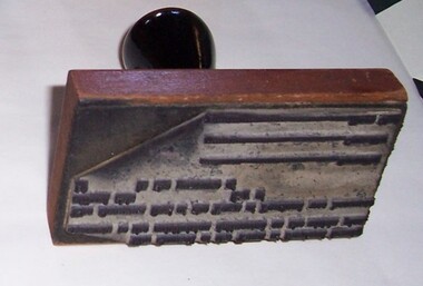
Functional object - Stamp - Subdivision Permit Stamp, n.d
Portland Town CouncilSubdivision Permit Stamp -
 Ringwood and District Historical Society
Flyer, Land Sale Advertisement - East Ringwood Township Estates, East Ringwood, Victoria - circa 1920
The date of the flyer as circa 1920 can be estimated from the references to the (decision on) "electrification of the Croydon Railway Line" which eventually occurred in 1923, letting of tenders for the state school building which opened in 1924, and the "proposed new railway station" (East Ringwood) which opened in 1925, Advertisement for three retail and residential allotment land sales in East Ringwood Township including maps showing layout of subdivisions. Township Estate, State School Estate, and East Ringwood Station Estate.Subdivision plans include Mount Dandenong Road, Grey Street, Eastfield Road, King Street, Everard Road, Holland Road, Purser Avenue, and Charles Street. (Agents) Spencer Jackson, Subdivider & Homebuilder, 341 Collins Street, Melbourne, Phones: M2327 (3 lines), also at Dromana, Phone 65. -
 City of Kingston
Pamphlet - Colour, W. H. Wood Estate Agent, Subdivisional Land Auction Barker's Estate Cheltenham, 1919
Sales plan for land in the suburb of Cheltenham, along Barker StreetThe developing urban area of Cheltenham within the City of Kingston. This land sale pamphlet illustrates the subdivision of land within the municipality and the changing demographic of the district as new houses are constructed.Colour pamphlet advertising subdivisional land auction of Barker's estate, on Barker Street Cheltenham.Handwritten in grey pencil on the subdivision map: a series of numbers on each block possibly indicating the sale price. Handwritten in grey pencil on the subdivision map: Roy- joined to subdivision 6 Handwritten in grey pencil on the subdivision map: x on the border between subdivision 17 and 16, and again on the border between subdivision 12 and 11.cheltenham, land sales, estate -
 Kew Historical Society Inc
Plan - Subdivision Plan, Goldthorns House Estate, 1940
Pru Sanderson, in her groundbreaking ‘City of Kew Urban Conservation Study : Volume 2 - Development History’ (1988), summarised the periods of urban development and subdivisions of land in Kew. The periods that she identified included 1845-1880, 1880-1893, 1893-1921, 1921-1933, 1933-1943, and Post-War Development. These periods were selected as they represented periods of rapid growth or decline in urban development. An obvious starting point for Sanderson’s groupings involved population growth and the associated economic cycles. These cycles also highlighted urban expansion onto land that was predominantly rural, although in other cases it represented the decline and breakup of large estates. A number of the plans in the Kew Historical Society’s collection can also be found in other collections, such as those of the State Library of Victoria and the Boroondara Library Service. A number are however unique to the collection.The Kew Historical Society collection includes almost 100 subdivision plans pertaining to suburbs of the City of Melbourne. Most of these are of Kew, Kew East or Studley Park, although a smaller number are plans of Camberwell, Deepdene, Balwyn and Hawthorn. It is believed that the majority of the plans were gifted to the Society by persons connected with the real estate firm - J. R. Mathers and McMillan, 136 Cotham Road, Kew. The Plans in the collection are rarely in pristine form, being working plans on which the agent would write notes and record lots sold and the prices of these. The subdivision plans are historically significant examples of the growth of urban Melbourne from the beginning of the 20th Century up until the 1980s. A number of the plans are double-sided and often include a photograph on the reverse. A number of the latter are by noted photographers such as J.E. Barnes.The first subdivision of Goldthorns created the Goldthorns Hill Estate. Following that subdivision, seven additional lots were offered between Normanby Road, Argyle Road and Lady Loch’s Drive on the proviso that the estate, including Goldthorns was not sold as a single lot. The subdivision plan advises that the lots are situated in one of the most charming and popular residential areas in Kew and is surrounded by modern homes. Typically, the subdivision plan proposes the advantage of its proximity to Cotham Road and the tram to Collins Street. Because of the elevation of Goldthorns, much is made of the ‘bright, sunny and extensive outlook to the Northern Ranges’ and that it overlooks the Yarra Valley. One of the more interesting aspects of the plan is that it shows the outline of Goldthorns in the mid to late 1920s. Its profile today remains virtually the same."Goldthorns" House Estate at topsubdivision plans - kew, goldthorns house estate -
 Ringwood and District Historical Society
Document - Folder, Byways Estate Residential Subdivision, Ringwood East, Victoria 1965-1970
Collection of Subdivision brochures, plans, maps and sales information for sectional releases of Byways Estate.Subdivision plans include: First and second release (1965-66) - Alexandra Road, Isabel Avenue, Byways Drive and Buronga Avenue. Third release (1967) - Byways Drive, Buronga Avenue, Hender Street, Lester Avenue and Jess Court. Fourth and final release (1970) - Hume Street, Walhalla Drive and Hender Street. (Agent) C.E. Carter & Son R.E.S.I. 126 Whitehorse Road, Ringwood, 3134 (Telephone) 870 2519, 870 6830, 870 6024, A.H. 723 3298, 870 4604, 870 6454. Accompanying handwritten sales notes researched in 2024 by Richard Carter - Carter Real Estate - "Vendors - Jessie May Cleland & Alan Cleland of (what became) 4 Bywats Drive. Vendors retired to Buronga near Mildura. Rex was (I think) their son. Jess Court reflects vendor's name. See also History of Byways & Coolooli by Richard Carter in RDHS archives." (Vic Collections RDHS 18023 refers.) -
 Ringwood and District Historical Society
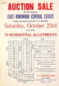
Flyer, Land Auction Sale Advertisement, East Ringwood Central Estate - 1948
See Victorian Collections reference 5125 for subsequent Central Estate East Ringwood subdivision flyer.Single sided land auction sale advertisement for residential allotments.Auction Sale on the property under instructions from Mr. F.A. Salter. Subdivision includes Dublin Road, Knaith Road, Talofa Avenue, Russet Road, and Shasta Avenue. Agent - C.E. Carter & Son, Main Street, Ringwood. WU 6024. -
 Whitehorse Historical Society Inc.
Document, Certificate of Title, 1928, 1933-1934
Certificate of Title, Nanny Schifferdecker.Certificate of Title, Nanny Schifferdecker. Lots 44, 45,56 & 57 subdivision 3360 Crown portion 97 Parish of Nunawading, County of Bourke 1928. Vol 5406 fol 10881070 1928, Agnew and Craig Streets. Also correspondence re rates enforcement charge 1933.Certificate of Title, Nanny Schifferdecker. land titles, shire of blackburn and mitcham, schifferdecker, hanny, craig street, blackburn south, agnew street, blackburn south -
Bendigo Historical Society Inc.
Book - ROLL OF ELECTORS - MARONG 1969
Roll of electors subdivision of Marong - 1969government, state, electoral roll -
Bendigo Historical Society Inc.
Book - ROLL OF ELECTORS STRATHFIELDSAYE - 1969
Roll of electors subdivision of Strathfieldsaye - 1969government, state, electoral roll -
 Ringwood and District Historical Society
Map, Partially Trimmed Copy of Elphin Estate, Ringwood, Vic. - (Undated, circa 1940s)
Clipped subdivision map on cardboard backing.Faint handwritten sales notations on and around numbered allotments in Heywood Street, Maidstone Street and Barkly Street, Ringwood.Surrounding streets also include Lutchie Street (later Sylvia Grove) and incorrect spelling of Barkly Street as Barkley. -
 Kew Historical Society Inc
Plan - Subdivision Plan, Bonnie Doon Estate, c.1908
Pru Sanderson, in her groundbreaking ‘City of Kew Urban Conservation Study : Volume 2 - Development History’ (1988), summarised the periods of urban development and subdivisions of land in Kew. The periods that she identified included 1845-1880, 1880-1893, 1893-1921, 1921-1933, 1933-1943, and Post-War Development. These periods were selected as they represented periods of rapid growth or decline in urban development. An obvious starting point for Sanderson’s groupings involved population growth and the associated economic cycles. These cycles also highlighted urban expansion onto land that was predominantly rural, although in other cases it represented the decline and breakup of large estates. A number of the plans in the Kew Historical Society’s collection can also be found in other collections, such as those of the State Library of Victoria and the Boroondara Library Service. A number are however unique to the collection.The Kew Historical Society collection includes almost 100 subdivision plans pertaining to suburbs of the City of Melbourne. Most of these are of Kew, Kew East or Studley Park, although a smaller number are plans of Camberwell, Deepdene, Balwyn and Hawthorn. It is believed that the majority of the plans were gifted to the Society by persons connected with the real estate firm - J. R. Mathers and McMillan, 136 Cotham Road, Kew. The Plans in the collection are rarely in pristine form, being working plans on which the agent would write notes and record lots sold and the prices of these. The subdivision plans are historically significant examples of the growth of urban Melbourne from the beginning of the 20th Century up until the 1980s. A number of the plans are double-sided and often include a photograph on the reverse. A number of the latter are by noted photographers such as J.E. Barnes.The subdivision advertised as the Bonnie Doon Estate in Greensborough was first advertised in 1908. At that stage, the new subdivision included 15 allotments of between one and four acres. By the time the subdivision plan in the Kew Collection was created, only 12 lots of between ¾ and 2½ acres remained. Both the State Library and Kew plans emphasise the distance to the city being 13½ miles, which could be reached by train on weekdays and weekends. Unusually, the plan describes the suitability of lots as locations for ‘Week-end Homes’. Correspondingly, the train line is described as ‘The Holiday Resort for the Northern Suburbs’.bonnie doona estate, subdivision plans - greensborough -
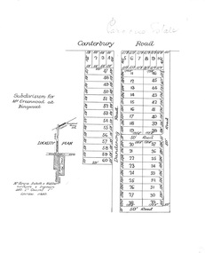 Ringwood and District Historical Society
Plan, Paradise Estate Subdivision, Ringwood, Victoria - circa 1925
Paradise Estate layout also included in Land Sale Brochure Titled Eureka Plan Book - Seven Delightful & Valuable Ringwood Estates - circa 1925, Reg. No. 5100.Subdivision plan of Paradise Estate, Ringwood, showing allotments for sale, with typed page attached showing block sizes and prices.Locality plan showing land for sale south of Canterbury Road, 1 Mile south of Ringwood Railway Station. Subdivison includes Canterbury Road and Dandenong Road (later Wantirna Road). Surveyors - McKenzie Aisbett & Webber, surveyors & engineers, 440 Little Collins Street, Melbourne, Telephone Central 11540. Subdivision for Mr Grenwood at Ringwood. Additional typewritten price list showing footage, price per foot, and price per block for Lots No. 1 to 60. Paradise Estate layout also included in Land Sale Brochure Titled Eureka Plan Book - Seven Delightful & Valuable Ringwood Estates - circa 1925, Reg. No. 5100. -
 Kew Historical Society Inc
Plan - Subdivision Plan, Altyre Estate, 1920, 1920
Pru Sanderson, in her groundbreaking ‘City of Kew Urban Conservation Study : Volume 2 - Development History’ (1988), summarised the periods of urban development and subdivisions of land in Kew. The periods that she identified included 1845-1880, 1880-1893, 1893-1921, 1921-1933, 1933-1943, and Post-War Development. These periods were selected as they represented periods of rapid growth or decline in urban development. An obvious starting point for Sanderson’s groupings involved population growth and the associated economic cycles. These cycles also highlighted urban expansion onto land that was predominantly rural, although in other cases it represented the decline and breakup of large estates. A number of the plans in the Kew Historical Society’s collection can also be found in other collections, such as those of the State Library of Victoria and the Boroondara Library Service. A number are however unique to the collection.The Kew Historical Society collection includes almost 100 subdivision plans pertaining to suburbs of the City of Melbourne. Most of these are of Kew, Kew East or Studley Park, although a smaller number are plans of Camberwell, Deepdene, Balwyn and Hawthorn. It is believed that the majority of the plans were gifted to the Society by persons connected with the real estate firm - J. R. Mathers and McMillan, 136 Cotham Road, Kew. The Plans in the collection are rarely in pristine form, being working plans on which the agent would write notes and record lots sold and the prices of these. The subdivision plans are historically significant examples of the growth of urban Melbourne from the beginning of the 20th Century up until the 1980s. A number of the plans are double-sided and often include a photograph on the reverse. A number of the latter are by noted photographers such as J.E. Barnes.The Altyre Estate was advertised for sale by auction in 1920. A colour lithograph in the State Library of Victoria, in contrast to this monochrome version, notes the proximity of the subdivision to the Auburn Heights Bowling Club and to a range of transport options. The subdivision included fifty-one allotments as well as the original house ‘Altyre’ in Barkers Road. This version includes the amounts paid as deposit on a number of lots.subdivision plans - kew, altyre estate – kew (vic), barkers road – kew (vic), walsh street – kew (vic), ross street – kew (vic), loxton street – kew (vic), mount street – kew (vic), auburn heights bowling club, altyre -
![Escol Estate [Kew], 1940](/media/collectors/550653872162f11fb04854aa/items/59115843d0ce2b1f048f0fbb/item-media/591158fdd0ce2e1f04f1e0f5/item-fit-380x285.jpg) Kew Historical Society Inc
Kew Historical Society IncPlan - Subdivision Plan, Escol Estate [Kew], 1940, 1940
Pru Sanderson, in her groundbreaking ‘City of Kew Urban Conservation Study : Volume 2 - Development History’ (1988), summarised the periods of urban development and subdivisions of land in Kew. The periods that she identified included 1845-1880, 1880-1893, 1893-1921, 1921-1933, 1933-1943, and Post-War Development. These periods were selected as they represented periods of rapid growth or decline in urban development. An obvious starting point for Sanderson’s groupings involved population growth and the associated economic cycles. These cycles also highlighted urban expansion onto land that was predominantly rural, although in other cases it represented the decline and breakup of large estates. A number of the plans in the Kew Historical Society’s collection can also be found in other collections, such as those of the State Library of Victoria and the Boroondara Library Service. A number are however unique to the collection.The Kew Historical Society collection includes almost 100 subdivision plans pertaining to suburbs of the City of Melbourne. Most of these are of Kew, Kew East or Studley Park, although a smaller number are plans of Camberwell, Deepdene, Balwyn and Hawthorn. It is believed that the majority of the plans were gifted to the Society by persons connected with the real estate firm - J. R. Mathers and McMillan, 136 Cotham Road, Kew. The Plans in the collection are rarely in pristine form, being working plans on which the agent would write notes and record lots sold and the prices of these. The subdivision plans are historically significant examples of the growth of urban Melbourne from the beginning of the 20th Century up until the 1980s. A number of the plans are double-sided and often include a photograph on the reverse. A number of the latter are by noted photographers such as J.E. Barnes.The ‘Escol Estate’ was a subdivision, which created Bramley Court, which runs south from Sackville Street between Evans Road and Orford Avenue. The subdivision was comprised of 12 lots. At the auction of the lots in May 1940, eight of the 12 allotments were sold. The land was sold subject to a restriction of only one private residence being erected on each lot.subdivision plans - kew, sackville street – kew (vic.), bramley court – kew (vic.) -
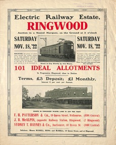 Ringwood and District Historical Society
Flyer, Land Sale Auction Brochure, Electric Railway Estate, Ringwood, Vic. - 1922
Bi-folded single sheet with black and red print both sides advertising auction of allotments on Saturday, November 18, 1922, including details of subdivision features and local facilities. Subdivision includes Bedford Road, Williams Grove, Campbell Street, Myrtle Avenue, George Street, and Henry Street. Agents - F.H. Patterson & Co., 19 Queen Street, Melbourne, Tel. 4308 Central, J.B. McAlpin, Opposite Railway Station, Ringwood, Tel 7 Ringwood, SYDNEY T. Haynes & Co., Auctioneer, 60 Queen Street, Melbourne, Tel 3400 Central. -
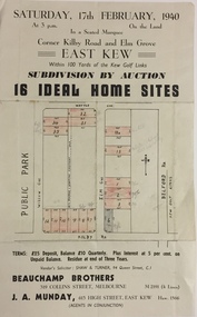 Kew Historical Society Inc
Plan - Subdivision Plan, Subdivision by Auction: 16 Ideal Home Sites, East Kew, 1940, 1940
An advertisement for the sale of a subdivision by Auction: of 16 Ideal Home Sites, East Kew, 1940. This significant sale of land between the Kew Golf Course and Willsmere Park led to the streets having a high degree of architectural uniformity.The subdivision in the second year of the war indicates that land sales for homes and speculation continued from the 1930s into the period of the Second World War. There is no indication on the plan that a war is occurring.Single page subdivision plan advertising the sale by Auction of 16 Ideal Home Sites, in East Kew, on 17 February 1940. Streets named in the plan include: Kilby Road, Belford Road, Elm Grove, Willow Grove. Willsmere Park is indicated but not named. The auction was conducted by Beauchamp Brothers. A number of lots are coloured pink on the plan indicating those lots for sale and/or those already sold.subdivision plans - kew east (vic) -
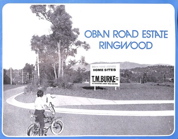 Ringwood and District Historical Society
Flyer, Land Sale Advertisement, Oban Road Estate, Ringwood, Vic. - 1974
Double-sided folded page with blue border advertising sale of Oban Road Estate Ringwood building allotments. Front page features photograph of view from the estate towards Dandenong Ranges. Centrefold pages include terms of sale, layout and features of the subdivision, and summary of local services. Photocopy of typewritten price list for the 52 lots also attached.Subdivision includes Oban Road, Ambrie Avenue, Hendra Grove, and Mullum Mullum Road. (Agent) T.M. Burke Pty Ltd., 63 Exhibition Street Melbourne, Telephone 654 4144. -
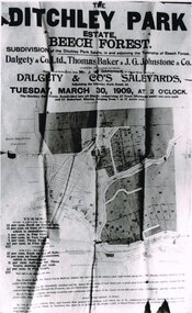 Otway Districts Historical Society
Photograph, Knox Collection, Sale of the Ditchley Park Estate, Beech Forest, 1908
Commercial realities and bushfires caused the Beech Forest community to re-establish itself around the railway station, away from Gardner Hill. This caused John W. Gardner to subdivide his land on the north side of the railway station. One subdivision was created near the Ditchley railway station on the old racecourse site, and another of 25 allotments forming what became Southorn Street. There were very few takers for these lots nor any buyers for the Ditchley subdivision.Photocopy. 260mm x 159mm. An advertisement for the sale of the Ditchley Park Estate, Beech Forest. Under instructions from Mr. J.W. Gardner Dalgety & Co. Ltd. will sell the subdivision of the Ditchley Park Estate on Tuesday, March 30, 1909, at 2 o'clock. A map of Beech Forest township and the Ditchley Park Estate is attached, as are the terms of sale and a description of the area.. beech forest; ditchley park; land sale; advertisment; -
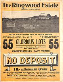 Ringwood and District Historical Society
Pamphlet - Land Auction Brochure, The Ringwood Estate - Second Sub-Division, Ringwood, Victoria - 1919
Double sided bi-fold leaflet advertising subdivision site, layout of streets and allotments, summary of local features and services and terms of sale. Auction Saturday June 14th, 1919. 55 Lots. Subdivision includes Warrandyte Road, Tamar Street, Mersey Street and Derwent Street. Property Sales - Dunlop & Hunt Home Builders Ltd., 317 Collins Street, Melbourne, Tels 10104-10105. Agents - J.B. McAlpin, Tel. Ringwood 7. Auctioneers - Sydney T. Haynes & Co., 60 Queen Street, Melbourne, Tel. 3400. Solicitors - Hodgson & Finlayson, 360 Collins Street, Melbourne. Inset photographs of local views including existing 4-roomed bungalow on Lot 37 Tamar Street. -
Stawell Historical Society Inc
Map, The Litho Co Ballarat, Glyntowyn Estate Campbells Bridge 1909, 1909
Shows Hoestead CC McCulloch ESQPaper map / Poster Advertising Subdivision of EstateMitchell Bros & White. 5003 Acres The Litho Co Ballarat Black Printing with Red Coloured Sectionsfarming -
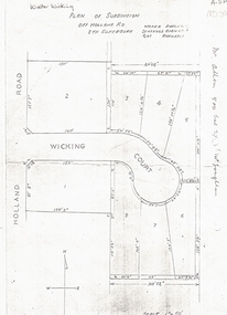 Whitehorse Historical Society Inc.
Document, Walter Wicking Plan of Subdivision, ?1952
Plan of subdivision for Wicking CourPlan of subdivision for Wicking Court, South Blackburn.Plan of subdivision for Wicking Courland subdivision, wicking court, blackburn south, wicking, walter benjamin, holland road -
Bendigo Historical Society Inc.
Book - ROLL OF ELECTORRS - GOLDEN SQUARE 1969
roll of electors, subdivision of Golden Square - 1969government, state, electoral roll -
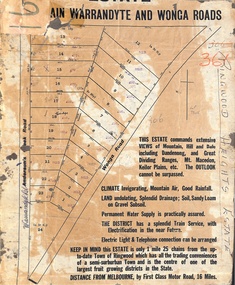 Ringwood and District Historical Society
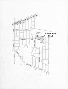
Map, Partially Trimmed Copy of Ringwood Heights Estate, Ringwood, Vic. - circa 1923
Clipped copy of a subdivision advertisement on cardboard backing. Sales notations on numbered allotments in Andersons's Creek Road (later Warrandyte Road) and Wonga Road, Ringwood. Handwritten title reference - LP7305. Captions - This Estate commands extensive views of mountain, hill and dale including Dandenong and Great Dividing Ranges, Mt. Macedon, Keilor Plains, etc. The outlook cannot be surpassed. Climate invigorating, mountain air, good rainfall. Land undulating, splendid drainage; soil, sandy loam on gravel subsoil. Permanent water supply is practically assured. The district has a splendid train service, with electrification in the near future. Electric light & telephone connection can be arranged. Keep in mind this estate is only 1 mile 25 chains from the up-to-date town of Ringwood which has all the trading conveniences of a semi-suburban town and is the centre of one of the largest fruit growing districts in the state. Distance from Melbourne by first class motor road, 16 miles. -
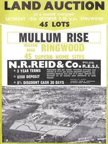 Ringwood and District Historical Society
Flyer, Land Auction Advertisement, Mullum Rise, Ringwood - 1970
Double sided leaflet with aerial view of part of Ringwood showing subdivision site, terms of sale, layout of streets and allotments, and summary of local features and services.Land auction, Saturday, 10th October (1970). 45 home sites. Subdivision includes Mullum Mullum Road, Hugh Street, Rollington Drive, Cassandra Court, and Jeffrey Drive. Surveyors - R.G. Lee Pty. Ltd., 6 Davis Street, Richmond. Agents - N.R. Reid & Co., 173 Coleman Parade, Glen Waverley, (Telephone) 560 0355 A.H. 560 0361 and Safeway Centre, Boronia Road, Boronia, (Telephone) 762 1022 A.G. 795 2887, also at East Malvern and Mount Waverley. -
 Kew Historical Society Inc
Plan, Studley Heights Estate, 1936
Pru Sanderson, in her groundbreaking ‘City of Kew Urban Conservation Study : Volume 2 - Development History’ (1988), summarised the periods of urban development and subdivisions of land in Kew. The periods that she identified included 1845-1880, 1880-1893, 1893-1921, 1921-1933, 1933-1943, and Post-War Development. These periods were selected as they represented periods of rapid growth or decline in urban development. An obvious starting point for Sanderson’s groupings involved population growth and the associated economic cycles. These cycles also highlighted urban expansion onto land that was predominantly rural, although in other cases it represented the decline and breakup of large estates. A number of the plans in the Kew Historical Society’s collection can also be found in other collections, such as those of the State Library of Victoria and the Boroondara Library Service. A number are however unique to the collection.Subdivision plans are historically important documents used as evidence of the growth of suburbs in Australia. They frequently provide information about when the land was sold on which a built structure was subsequently constructed as well as evidence relating to surveyors and real estate and financial agents. The numerous subdivision plans in the Kew Historical Society's collection represent working documents, ranging from the initial sketches made in planning a subdivision to printed plans on which auctioneers or agents listed the prices for which individual lots were sold. In a number of cases, the reverse of a subdivision plan in the collection includes a photograph of a house that was also for sale by the agent. These photographs provide significant heritage information relating house design and decoration, fencing and household gardens.The ‘Studley Heights Estate’ on the South Side of Studley Park Road was launched in 1936. The seventeen allotments in the subdivision fronted Hyton Crescent and Studley Park Road.subdivision plans - kew, studley heights estate -
Kew Historical Society Inc
Plan - Camberwell Panorama Estate, 1923
Subdivision plans and real estate flyers/brochures reveal a number of aspects of urban development and history. The Kew Historical Society's collection of these plans, as well as advertisements extracted from magazines, cover key aspects of community development and architectural history of Kew and Kew Eat as well as surrounding suburbs. While most of the plans in the collection were gifted to the Society by the former City of Kew, a number of other plans and advertisements have been donated by individuals, of which this is an example.Promotional brochure for the Camberwell Panorama Estate. The four page bifold handout advertises 216 home sites bounded by Bulleen Road, The Nook, Fortuna Avenue, and Doncaster Road. Other streets in the subdivision include: Sunburst Avenue, The Moor, and Macedon Avenue. The brochure has been damaged at some time in the past and so masking tape obscures the tram on page 1. Page 2 includes the plan of the subdivision, page 3 information about the site and a locality plan, while page 4 includes photographs and terms of sale. subdivision plans -- balwyn north (vic.), camberwell panorama estate -
Kew Historical Society Inc
Plan - Willsmere Park Estate, Kew, 1926
Subdivision plans and real estate flyers/brochures reveal a number of aspects of urban development and history. The Kew Historical Society's collection of these plans, as well as advertisements extracted from magazines, cover key aspects of community development and architectural history of Kew and Kew Eat as well as surrounding suburbs. While most of the plans in the collection were gifted to the Society by the former City of Kew, a number of other plans and advertisements have been donated by individuals, of which this is an example.Original 4-page, bifold subdivision plan of the Willsmere Park Estate, Kew. The 1926 land sale advertised '40 superb villa allotments' on the 'Yarra Heights'. Streets within the subdivision included: Willow Grove, Kilby Road, Elm Grove and Belford Road. The double page spread on pages 2 and 3 shows the detailed plan of the 40 lots, surrounded by public parkland [Willsmere Park] and the Kew Golf Links. By the time that this version of the plan was released, only the lots on Willow Grove and Kilby Road remained. willsmere park estate -- kew (vic.), subdivisions - kew (vic.), subdivisions -- kew east (vic.), willsmere park -- kew east (vic.) -
 Kew Historical Society Inc
Plan - Subdivision Plan, Jas R Mathers Son & McMillan, Clifton Estate, Kew, c. 1916
Pru Sanderson, in her groundbreaking ‘City of Kew Urban Conservation Study : Volume 2 - Development History’ (1988), summarised the periods of urban development and subdivisions of land in Kew. The periods that she identified included 1845-1880, 1880-1893, 1893-1921, 1921-1933, 1933-1943, and Post-War Development. These periods were selected as they represented periods of rapid growth or decline in urban development. An obvious starting point for Sanderson’s groupings involved population growth and the associated economic cycles. These cycles also highlighted urban expansion onto land that was predominantly rural, although in other cases it represented the decline and breakup of large estates. A number of the plans in the Kew Historical Society’s collection can also be found in other collections, such as those of the State Library of Victoria and the Boroondara Library Service. A number are however unique to the collection.The Kew Historical Society collection includes almost 100 subdivision plans pertaining to suburbs of the City of Melbourne. Most of these are of Kew, Kew East or Studley Park, although a smaller number are plans of Camberwell, Deepdene, Balwyn and Hawthorn. It is believed that the majority of the plans were gifted to the Society by persons connected with the real estate firm - J. R. Mathers and McMillan, 136 Cotham Road, Kew. The Plans in the collection are rarely in pristine form, being working plans on which the agent would write notes and record lots sold and the prices of these. The subdivision plans are historically significant examples of the growth of urban Melbourne from the beginning of the 20th Century up until the 1980s. A number of the plans are double-sided and often include a photograph on the reverse. A number of the latter are by noted photographers such as J.E. Barnes.The Clifton Estate was an ambitious subdivision. It included 61 allotments bordering Cotham and Park Hill Roads, and Florence and Adeney Avenues. It is difficult to ascertain the exact year when the ‘Clifton Estate’ was surveyed, subdivided and first auctioned. The uncertainty may be due to allotments being released during the First World War. The subdivision took its name from the house ‘Clifton’ (lot 5) on the corner of Adeney Avenue and Cotham Road. The outline of Clifton (since demolished) and the extent of its land following the subdivision are represented on the plan. The auctioneers have also shown ‘Maryfield’ and ‘Wimba’, the neighbouring properties in Cotham Road, on the plan."B"subdivision plans - kew, clifton estate, cotham road, adeney avenue, florence avenue, park hill road