Showing 336 items matching "the future is now"
-
 Vision Australia
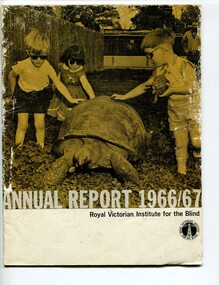
Administrative record - Text, Royal Victorian Institute for the Blind annual report 1966-1967, 1966-1967
Articles in annual report include: Office bearers of the institute/officers, President's report - 100 years, Residence nursery and school for blind children - in 1866 first nine blind children were accommodated in temporary premises in Commercial Road Prahran, the budget was $822 pounds, now the facility in Burwood can house 70 children and the, budget is $160,000, New found confidence after rehabilitation, Blind welfare work increases, Our factory now serves industry, Employ opportunities are widening, Our loyal auxiliaries and other supporters, What of the future, Income and expenditure, Where there's a will there's a way to help blind people. Events that occurred in 1966 : Millet broom making was discontinued and mat and industrial brush making and packing and assembly began, the Governor of Victoria and Lady Delacombe brought their dog to visit the children at the school, the Institute began two vital new projects - providing a residential geriatric facility and to establish the RVIB foundation for research and education.1 volume of print and illustrationsannual reports, royal victorian institute for the blind -
 Vision Australia
Text, Royal Victorian Institute for the Blind annual report 1960-1961, 1960-1961
Articles in annual report include: List of RVIB president, office bearers of the institute and officers of the institute, Programme and achievements - future programme is in your hands, Activities, Programme maintained - ninety six years of service, Recent years, Resident nursery and school, Other children's activities, Deaf blind children, Higher education, Employment, Finance, Rehabilitation, Recreation and social activities, Talking book library, Public appeal - Aug 1962, Appreciation, 3KZ Christmas day appeal, Concerts, Board of management, 35th annual report of council of auxiliary. Events that occurred in 1961 : School started a scented garden, library now has been consolidated and a new physical education block opened with an indoor heated pool, fully equipped gym, showers and dressing room.1 volumeroyal victorian institute for the blind, annual reports -
 Federation University Art Collection
Ceramic - Artwork - Ceramics, [Untitled]
Jan FEDER ( - 1981) Jan Feder is an alumna of Federation University having studied ceramics at the Gippsland Institute of Advanced Education (now Federation University Gippsland campus). Jan Feder was respected by all students for her diligence and technical ability. Her tragic death in 1981 evoked an immediate response from her peers for a memorial. Students discussed a number of memorial options, such as funds for equipment, scholarships and awards. The decision to commence a collection was made based on the idea that all future students could benefit from the availability of a collection, whereas only a very few individuals could benefit from a scholarship. Students immediately set about raising money by selling 'seconds' called 'Junque Sales'. a total of $760.00 was raised and the first two works purchased were by Victor Greenaway and Victoria Howlett. Ceramic works were purchased from visiting lecturers who became leading ceramic artists around the world, as well as from many of the staff who taught at the Gippsland Campus. The Artist in Residence Program assisted the collection, with many resident artists contributing to the Collection (ie Robin Welch, Anna Zamorska, Sandy Brown), as well as international guests. Ceramic events such as 'Strzelecki Spotkanie 1984' and 'Woodfire 86' also resulted on major contributions to the collection. Jan Feder Memorial Ceramics Collectionjan feder, jan feder memorial collection, ceramics, gippsland campus -
![Ceramic - Artwork - Ceramics, Untitled [Pair Tea Cups], by Silvia Richardson, c1985, c1985](/media/collectors/530576742162ef0fa09a2288/items/56b7f64c2162f11c0c8c7590/item-media/59d0c82d21ea690cc8367f56/item-fit-380x285.jpg) Federation University Art Collection
Federation University Art CollectionCeramic - Artwork - Ceramics, Untitled [Pair Tea Cups], by Silvia Richardson, c1985, c1985
Silvia RICHARDSON A post graduate student at the Gippsland Centre for Art and Desish (GCAD) who presented this work to the Jan Feder Art Collection. Jan Feder was an alumna of Federation University having studied ceramics at the Gippsland Institute of Advanced Education (now Federation University Gippsland campus). Jan Feder was respected by all students for her diligence and technical ability. Her tragic death in 1981 evoked an immediate response from her peers for a memorial. Students discussed a number of memorial options, such as funds for equipment, scholarships and awards. The decision to commence a collection was made based on the idea that all future students could benefit from the availability of a collection, whereas only a very few individuals could benefit from a scholarship. Students immediately set about raising money by selling 'seconds' called 'Junque Sales'. a total of $760.00 was raised and the first two works purchased were by Victor Greenaway and Victoria Howlett. Ceramic works were purchased from visiting lecturers who became leading ceramic artists around the world, as well as from many of the staff who taught at the Gippsland Campus. The Artist in Residence Program assisted the collection, with many resident artists contributing to the Collection (ie Robin Welch, Anna Zamorska, Sandy Brown), as well as international guests. Ceramic events such as 'Strzelecki Spotkanie 1984' and 'Woodfire 86' also resulted on major contributions to the collection. Two low tempreture fused slipcase bone china with inlaid decoration. Jan Feder Memorial Collectionjan feder memorial collection, jan feder, sylvia richardson, ceramics, gippsland campus, artwork, artist -
 Vision Australia
Administrative record - Text, The Association for the Blind, Blind Members' Council meeting minutes 5/11/1982 to 24/2/1986, 1982-1986
These meetings were held at the Kooyong office and the minutes include Present, Chair, Apologies, Minutes, Matter arising from minutes, Correspondence, Life governors, Election of members, Nominations, Reports from Regional Blind Members groups, White Cane Day October 15th promoted. Some highlights include: 3/12/1982 the film, 'A world that is dark', which was made by AFB for television release is now available on video. 31/8/1984 the Blind members' brochure includes sections titled 'Yesterday, Today and Tomorrow' which outlines the history, present position and the aims for the future of the AFB, 'Information about Blind Members' and Blind Members' Council', List of AFB homes and centres' and 'An invitation from Bryan Sitlington to be a Blind Member accompanied by an application form. It will be available to all visually impaired people, their family and friends, AFB staff and suitable for distribution at doctor's surgeries. 14/12/1984 it was reported 29 new Blind members were elected at the September meeting and the 1,000th member was among them. 8/6/1984 Mr John Blanch reported that the General Committee had approved, although rather reluctantly, Mr John Wilson's resignation and had appoint Mr John Cook as his successor. 13/9/1985 Mr John Blanch reported that following Mr Pat Lightfoot's resignation he had contacted Mr John Wicking to offer him the position of sighted representative on Blind Members' Council. John Wicking had been approached for role on the BMC however he was unable to attend Fridays. It was moved to move the meetings to the last Monday of the Month, after approaching John Wicking again. Council members agreed that if John Wicking took the position it would be good as would have been held by Pat Lightfoot and John Wicking, both past Presidents of AFB. Mrs Margaret Canavan and Mr Alan Cooper had been selected to attend a garden party at Government House with Her Majesty the Queen and His Royal Highness the Duke of Edinburg on Thursday March 6. Minute book for Blind Members Councilassociation for the blind, blind members council -
 Vision Australia
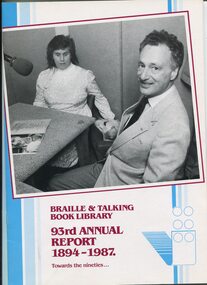
Administrative record - Text, Braille and Talking Book Library 93rd Annual Report 1894-1987: towards the nineties, 1987
Annual report of the Braille & Talking Book Library including Minutes of the AGM, Board of Director's Report, President's report and financial statements. Items also included are: CEP (Community Employment Programs) allowed for duplication of master tapes for storage off-site and development of computer catalogue records, budget estimate requires raising $600,000 in funds which has resulted in 1987 facing serious financial challenges, negotiations with RVIB broken down as print-handicapped philosophy not shared, Braille Book of the Year judges (Joyce Nicholson, Barrett Reid and Stephen Murray-Smith) shortlisted titles for readers to vote upon (John Bryson, Evil Angels) and best narrator (The Bathurst) went to Sean Myers, organisational restructure, resignation of Barbara Johnston and David Blyth, appointment of Jill Keeffe, new borrowers now waiting 11 months to receive first book due to limited staffing levels, bright orange cassette containers introduced (replacing pouches), Otari duplicating system first year in use, 'In Future' and 'Australian Geographic' began, 45 audio magazines including 1 Greek and 3 Italian now circulating, Braille Reading Marathon held, large print collection expanded due to Fitzroy Public Library discarding stock, Versapoint embosser purchased and link with Royal Society for the Blind in South Australia through Braille book catalogue.1 volume of text and illustrationsbraille and talking book library, annual report -
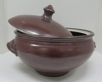 Federation University Art Collection
Ceramic - Artwork - Ceramics, Jan Feder, Lidded Stoneware Casseroles with iron glaze by Jan Feder, 1981
Jan FEDER ( - 1981) Jan Feder is an alumna of Federation University having studied ceramics at the Gippsland Institute of Advanced Education (now Federation Univesity Gippsland campus). Jan Feder was respected by all students for her diligence and technical ability. Her tragic death in 1981 evoked an immediate response from her peers for a memorial. Students discussed a number of memorial options, such as funds for equipment, scholarships and awards. The decision to commence a collection was made based on the idea that all future students culd benefit from the availability of a collection, whereas only a very few individuals could benefit from a scholarship. Students immediately set about raising money by selling 'seconds' called 'Junque Sales'. a total of $760.00 was raised and the first two works purchased were by Victor Greenaway and Victoria Howlett. Ceramic works were purchased from visiting lecturers who became leading ceramic artists around the world, as well as from many of the staff who taught at the Gippsland Campus. The Artist in Residendence Program assisted the collection, with many resident artists conrtibuting to the Collection (ie Robin Welch, Anna Zamorska, Sandy Brown), as well as international guests. Ceramic events such as 'Strzelecki Spotkanie 1984' and 'Woodfire 86' also resulted on major contributions to the collection. Three lidded pots by Jan Feder made in 1981.jan feder, jan feder memorial ceramics collection, ceramics, gippsland campus, alumni, casserole -
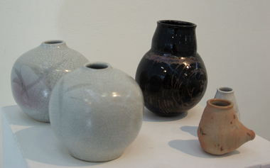 Federation University Art Collection
Ceramic - Stoneware, [Group of Vessels] by Jan Feder, 1980
Jan FEDER Born Barmera, South Australia Jan Feder was a student at the Gippsland Centre of Art and Design in the 1980s. She had started studying ceramics in Adelaide, deciding to continue here study at Churchill under Hedley Potts' tutelage after moving to Strezlecki. In her final year Jan was an on-campus weekday resident to save on the travel time. This work is part of the Jan Feder Memorial Ceramics Collection which was amassed with funds raised by Jan Feder's student peers at the Gippsland Centre for Art and Design in the mid 1980s after Jan Feder passed away. Although many of the works are donated the intention of the collection was to purchase from visiting lecturers who became leading ceramic artists around the world, as well as from many of the staff who taught at the Churchill Campus. A group of ceramic vessels by Jan Feder, an alumna of the Gippsland Centre for Art and Design (GCAD). After her death in the mid 1980s her student peers amassed funds to create a memorial collection. jan feder, jan feder memorial ceramics collection, gippsland campus, alumni, ceramics -
 Federation University Art Collection
Ceramic - Artwork - Ceramics, Bruce Stewart, Set of Five Salt-glazed Pots, by Bruce Stewart, 1979
Bruce STEWART A Diploma Student in Ceramics at the Gippsland Institute of Advanced Education from 1977 to 1979. Jan Feder is an alumna of Federation University having studied ceramics at the Gippsland Institute of Advanced Education (now Federation University Gippsland campus). Jan Feder was respected by all students for her diligence and technical ability. Her tragic death in 1981 evoked an immediate response from her peers for a memorial. Students discussed a number of memorial options, such as funds for equipment, scholarships and awards. The decision to commence a collection was made based on the idea that all future students could benefit from the availability of a collection, whereas only a very few individuals could benefit from a scholarship. Students immediately set about raising money by selling 'seconds' called 'Junque Sales'. A total of $760.00 was raised and the first two works purchased were by Victor Greenaway and Victoria Howlett. Ceramic works were purchased from visiting lecturers who became leading ceramic artists around the world, as well as from many of the staff who taught at the Gippsland Campus. The Artist in Residence Program assisted the collection, with many resident artists contributing to the Collection (ie Robin Welch, Anna Zamorska, Sandy Brown), as well as international guests. Ceramic events such as 'Strzelecki Spotkanie 1984' and 'Woodfire 86' also resulted on major contributions to the collection. Salt-glazed pots. Presented to the Jan Feder Memorial Ceramic Collection by Bruce Stewart jan feder memorial collection, jan feder, ceramics, gippsland campus, artwork, artist, bruce stewart, alumni -
![[CeramicSculptural Form] by Larrel Kane](/media/collectors/530576742162ef0fa09a2288/items/5efef3e521ea6712bcaee859/item-media/5efef41a21ea6712bcaf1450/item-fit-380x285.jpg) Federation University Art Collection
Federation University Art CollectionCeramic, [CeramicSculptural Form] by Larrel Kane, C1986
Larrel KANE A Diploma Student at the Gippsland Institute of Advanced Education. This item is a part of the Jan Feder Memorial Ceramics Collection. Jan Feder is an alumna of Federation University having studied ceramics at the Gippsland Institute of Advanced Education (now Federation University Gippsland campus). Jan Feder was respected by all students for her diligence and technical ability. Her tragic death in 1981 evoked an immediate response from her peers for a memorial. Students discussed a number of memorial options, such as funds for equipment, scholarships and awards. The decision to commence a collection was made based on the idea that all future students could benefit from the availability of a collection, whereas only a very few individuals could benefit from a scholarship. Students immediately set about raising money by selling 'seconds' called 'Junque Sales'. a total of $760.00 was raised and the first two works purchased were by Victor Greenaway and Victoria Howlett. Ceramic works were purchased from visiting lecturers who became leading ceramic artists around the world, as well as from many of the staff who taught at the Gippsland Campus. The Artist in Residence Program assisted the collection, with many resident artists contributing to the Collection (ie Robin Welch, Anna Zamorska, Sandy Brown), as well as international guests. Ceramic events such as 'Strzelecki Spotkanie 1984' and 'Woodfire 86' also resulted on major contributions to the collection. Earthernware Sculpure with hand thrown element. Gift of the Artist Jan Feder Memorial Ceramics Collectionjan feder memorial collection, ceramics, jan feder, woodfire, churchill, jan feder memorial ceramics collection, alumni -
Federation University Art Collection
Ceramic, [Decorated Bowl]
This work is part of the Jan Feder Memorial Ceramics Collection .Jan Feder is an alumna of Federation University having studied ceramics at the Gippsland Institute of Advanced Education (now Federation Univesity Gippsland campus). Jan Feder was respected by all students for her diligence and technical ability. Her tragic death in 1981 evoked an immediate response from her peers for a memorial. Students discussed a number of memorial options, such as funds for equipment, scholarships and awards. The decision to commence a collection was made based on the idea that all future students culd benefit from the availability of a collection, whereas only a very few individuals could benefit from a scholarship. Students immediately set about raising money by selling 'seconds' called 'Junque Sales'. a total of $760.00 was raised and the first two works purchased were by Victor Greenaway and Victoria Howlett. Ceramic works were purchased from visiting lecturers who became leading ceramic artists around the world, as well as from many of the staff who taught at the Gippsland Campus. The Artist in Residendence Program assisted the collection, with many resident artists conrtibuting to the Collection (ie Robin Welch, Anna Zamorska, Sandy Brown), as well as international guests. Ceramic events such as 'Strzelecki Spotkanie 1984' and 'Woodfire 86' also resulted on major contributions to the collection.A hand thrown stoneware bowl with with green, pink and black glaze decoration. If you can assist with information on this artist or artwork please use the email link below. jan feder memorial ceramics collection, alumni -
Federation University Art Collection
Ceramic, [Glazed Bowl]
This work is part of the Jan Feder Memorial Ceramics Collection .Jan Feder is an alumna of Federation University having studied ceramics at the Gippsland Institute of Advanced Education (now Federation Univesity Gippsland campus). Jan Feder was respected by all students for her diligence and technical ability. Her tragic death in 1981 evoked an immediate response from her peers for a memorial. Students discussed a number of memorial options, such as funds for equipment, scholarships and awards. The decision to commence a collection was made based on the idea that all future students culd benefit from the availability of a collection, whereas only a very few individuals could benefit from a scholarship. Students immediately set about raising money by selling 'seconds' called 'Junque Sales'. a total of $760.00 was raised and the first two works purchased were by Victor Greenaway and Victoria Howlett. Ceramic works were purchased from visiting lecturers who became leading ceramic artists around the world, as well as from many of the staff who taught at the Gippsland Campus. The Artist in Residendence Program assisted the collection, with many resident artists conrtibuting to the Collection (ie Robin Welch, Anna Zamorska, Sandy Brown), as well as international guests. Ceramic events such as 'Strzelecki Spotkanie 1984' and 'Woodfire 86' also resulted on major contributions to the collection.A hand thrown stoneware bowl with with a stunning gold and black glaze. If you can assist with information on this artist or artwork please use the email link below. jan feder memorial ceramics collection, alumni, japanese? -
Federation University Art Collection
Ceramic
This work is part of the Jan Feder Memorial Ceramics Collection .Jan Feder is an alumna of Federation University having studied ceramics at the Gippsland Institute of Advanced Education (now Federation Univesity Gippsland campus). Jan Feder was respected by all students for her diligence and technical ability. Her tragic death in 1981 evoked an immediate response from her peers for a memorial. Students discussed a number of memorial options, such as funds for equipment, scholarships and awards. The decision to commence a collection was made based on the idea that all future students culd benefit from the availability of a collection, whereas only a very few individuals could benefit from a scholarship. Students immediately set about raising money by selling 'seconds' called 'Junque Sales'. a total of $760.00 was raised and the first two works purchased were by Victor Greenaway and Victoria Howlett. Ceramic works were purchased from visiting lecturers who became leading ceramic artists around the world, as well as from many of the staff who taught at the Gippsland Campus. The Artist in Residendence Program assisted the collection, with many resident artists conrtibuting to the Collection (ie Robin Welch, Anna Zamorska, Sandy Brown), as well as international guests. Ceramic events such as 'Strzelecki Spotkanie 1984' and 'Woodfire 86' also resulted on major contributions to the collection.Two small, hand thrown woodfired pots. If you can assist with information on this artist or artwork please use the email link below. jan feder memorial ceramics collection, alumni -
 Royal District Nursing Service (now known as Bolton Clarke)
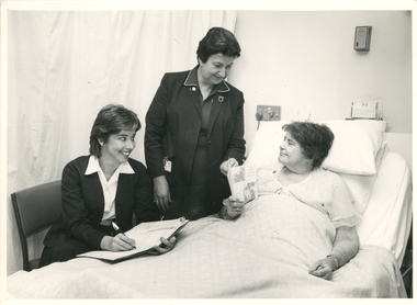
Photograph - Photograph, black and white, Barry Sutton, c.1970
This photograph shows Royal District Nursing Service (RDNS) Sister (Sr.) Moira Coates doing Liaison work at St. Vincent's Hospital in Melbourne. Miss C. Healy is St. Vincent's Home Care Supervisor and she and Sr. Coates are discussing plans with Miss E. Monks for the future care she requires following her discharge from hospital. Sr. Coates is wearing the RDNS uniform of a royal blue dress with white piping around the peaks of the collar. An RDNS logo is on its upper left. She is wearing a darker blue jacket.Liaison had occurred between Doctors and the the Trained nurses (Nurses) of the Melbourne District Nursing Society (MDNS), from its inception in 1885. This increased when Midwifery was introduced in August 1893 with close liaising with the Women’s Hospital. As District nursing grew it was recognized that closer liaising between many Public Hospitals would be beneficial, for not only the MDNS, later called Royal District Nursing Service (RDNS), Trained nurses (Sisters), but also for the patients and the hospitals. In August 1964 a Liaison Officer commenced at the Alfred Hospital. This soon increased to Liaison Officers working full time at several Public Hospitals. They facilitated the smooth transition from hospital to home for many patients who required ongoing nursing care. Liaison Sisters regularly attended discharge planning meetings, interviewed prospective patients, co-ordinated discharge and booked the first visit by the visiting RDNS Sister. At the time of a patient’s discharge, the Liaison Sister forwarded information on their diagnosis and instructions regarding the care required at home to the appropriate RDNS Centre, and in turn the attending District Sister wrote a report of progress and any queries to the Hospital Doctor, via the Liaison Sister, at the time the patient was attending outpatients. Any new instructions were then sent back to the District Sister. Liaising also occurred between District Sisters and Doctors when patients were referred by General Practitioners and did not attend a hospital.In the left foreground of this black and white photograph is Miss C. Healy who has collar length dark hair and is wearing a hospital uniform dark cardigan over a white blouse and dark skirt. She is sitting on a kitchen style chair and has an open folder; a pen in her right hand is poised over a white sheet of paper. She is smiling and looking to her left at Miss E. Monks who is resting in a bed in front of her. Standing to her right, and at the head of the bed, is RDNS Sister Moira Coates who has short dark hair. and is wearing a dark jacket over a dark colour dress with white piping on the collar peaks. Her identity card is clipped on the right hand pocket. She is smiling at Miss Monks and has her left hand on an RDNS leaflet which Miss Monks is holding. To her right is Miss Monk who has short dark hair and wearing a light coloured nightdress. She sitting up supported against pillows on a hospital bed which has the top section raised. She is looking at the RDNS folded leaflet; two photographs and writing can be seen on the front cover. White bedclothes cover most of Miss Monks body. Drawn curtains are seen in the left rear of the photograph and some switches and a name card are seen behind the bed. Barry Sutton. LJ93 and namesrdns, royal district nursing service, rdns liaison, rdns uniform, sister moira coates, miss c. healy, miss e. monks -
 Falls Creek Historical Society
Plan - Leases of part of Falls Creek Tourist Area
Bob (Herman) Hymans (a former member of the Royal Netherlands Navy was born in Bloemendaal, Holland on 30th September 1922. During World War II he fought against the Japanese in the Dutch East Indies (now Indonesia) and was imprisoned in Changi and on the Burma Railway. After gaining qualifications as a Ski Instructor, Bob arrived in Falls Creek in May 1950. Working as an Instructor and Supervisor at Bogong Lodge, Bob decided his future was in accommodation. He was successful in negotiating an indenture for land from the State Electricity Commission (SEC). It took Bob two years to build his Grande Coeur Chalet but, tragically, it was burned down in August 1961. Bob also built the first Chairlift in Australia. This was a single chairlift and the structure was built from wooden electricity poles. He was constantly full of new ideas and proposals for the village. Bob Hymans died on 7th May 2007. This Collection of documents and letters tells the story of Bob’s endeavours to develop Falls Creek into the ski village it is today. This map is significant because it documents boundaries of early leases in Falls Creek Tourist Area.This map is part of Bob Hymans documents. It is a large Surveyor's Plan of a section of the Falls Creek Tourist Area. It is endorsed by J Parker, Chief Surveyor of the State Electricity Commission of Victoria on 27-3-84. It shows streets, lot numbers and measurements. It was a compilation created from existing lease maps. Heading - PART OF FALLS CREEK TOURIST AREA PART OF CROWN ALLOTMENT 1 PARISH OF CARRUNO PART OF CROWN ALLOTMENT 1 PARISH OF DARBALANG COUNTY OF BOGONGmap of falls creek, falls creek leases, falls creek 1980s -
 Falls Creek Historical Society
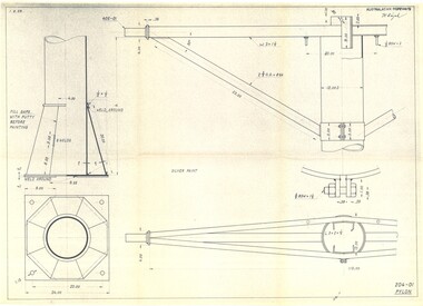
Plan - Diagram of Pylon for New Chairlift
Bob (Herman) Hymans (a former member of the Royal Netherlands Navy was born in Bloemendaal, Holland on 30th September 1922. During World War II he fought against the Japanese in the Dutch East Indies (now Indonesia) and was imprisoned in Changi and on the Burma Railway. After gaining qualifications as a Ski Instructor, Bob arrived in Falls Creek in May 1950. Working as an Instructor and Supervisor at Bogong Lodge, Bob decided his future was in accommodation. He was successful in negotiating an indenture for land from the State Electricity Commission (SEC). It took Bob two years to build his Grande Coeur Chalet but, tragically, it was burned down in August 1961. Bob also built the first Chairlift in Australia. This was a single chairlift and the structure was built from wooden electricity poles. He was constantly full of new ideas and proposals for the village. Bob Hymans died on 7th May 2007. This Collection of documents and letters tells the story of Bob’s endeavours to develop Falls Creek into the ski village it is today. This map is significant because it documents plans being proposed by Bob Hymans for Falls Creek.This diagram is part of Bob Hymans documents. It contains design drawings, measurements and cross sections for one of the pylons for a chairlift proposed by Bob Hymans. The design has been drawn up by Australasian Ropeways. It has been signed by Vladimir Hájek, a Czech engineer who Mr Hymans had consulted on several projects.Top right: AUSTRALASIAN ROPEWAYS with signature V. Hájek Bottom right: 204-01 PYLONmap of falls creek, falls creek leases, falls creek 1980s -
 Falls Creek Historical Society
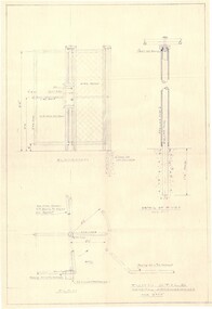
Plan - Diagram of Turnstile for New Chairlift
Bob (Herman) Hymans (a former member of the Royal Netherlands Navy was born in Bloemendaal, Holland on 30th September 1922. During World War II he fought against the Japanese in the Dutch East Indies (now Indonesia) and was imprisoned in Changi and on the Burma Railway. After gaining qualifications as a Ski Instructor, Bob arrived in Falls Creek in May 1950. Working as an Instructor and Supervisor at Bogong Lodge, Bob decided his future was in accommodation. He was successful in negotiating an indenture for land from the State Electricity Commission (SEC). It took Bob two years to build his Grande Coeur Chalet but, tragically, it was burned down in August 1961. Bob also built the first Chairlift in Australia. This was a single chairlift and the structure was built from wooden electricity poles. He was constantly full of new ideas and proposals for the village. Bob Hymans died on 7th May 2007. This Collection of documents and letters tells the story of Bob’s endeavours to develop Falls Creek into the ski village it is today. This map is significant because it documents plans made by Bob Hymans for Falls CreekThis diagram is part of Bob Hymans documents. It is a detailed plan, including elevation, detail of pivot and the general arrangement views of a turnstile. This is part of overall plans for the construction of a new chairlift at Falls Creek. At bottom of diagrams: PLAN TURNSTILE/ GENERAL ARRANGEMENT Scale 1 1/2" = 1'- 0"map of falls creek, falls creek leases, falls creek 1980s -
 Falls Creek Historical Society
Document - Circular - Parking - Charges Increased
Bob (Herman) Hymans (a former member of the Royal Netherlands Navy) was born in Bloemendaal, Holland on 30th September 1922. During World War II he fought against the Japanese in the Dutch East Indies (now Indonesia) and was imprisoned in Changi and on the Burma Railway. After gaining qualifications as a Ski Instructor, Bob arrived in Falls Creek in July 1950. Working as an Instructor and Supervisor at Bogong Lodge, Bob decided his future was in accommodation. He was successful in negotiating an indenture for land from the State Electricity Commission (SEC). It took Bob two years to build his Grand Coeur Chalet but, tragically, it was burned down in August 1961. Bob also built the first Chairlift in Australia. This was a single chairlift and the structure was built from wooden electricity poles. He was constantly full of new ideas and proposals for the village. Bob Hymans die on 7th July 2007. This Collection of documents and letters tells the story of Bob's endeavours to develop Falls Creek into the ski village it is today.This item is significant because it documents actions taken by the Falls Creek Tourist Area Management Committee in their role overseeing the Tourist Area.A circular from the Management Committee outlining regulations and parking fees for the winter of 1964falls creek tourist area management committee, falls creek administration, parking regulations falls creek -
 Melbourne Legacy
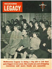
Flyer, Melbourne Legacy, 1962
A 4 page brochure on the activities of Melbourne Legacy published in October 1962. It outlines Legacy's activities including the residences, a legatee visiting a family Boys' classes such as basketball, judo and trampolining, Girls' classes such as gymnastics, the Legacy house library and dental clinic. It is aimed at educating people in industry and business. The title reads: An invitation to Business and Industry: Help us build the future'. Some of the text reads: Special appeals have been made only when the need has been clear and urgent. . . . Business and industry already give generous support the Legacy Endowment Scheme. Now we invite you to join with us in expanding that scheme to meet the needs both of today and of the years ahead." "an invitation to join with Legacy in building the future - by helping to train and educate thousands of children to become good citizens of a great country."A record of the work Legacy was doing at the time.Black and white brochure with pictures of JL activities from 1962.junior legatee, boys classes, girls classes, residences -
 Melton City Libraries
Photograph, Edna Barrie, 1920, 1924, 1933 and 1940
SUMMARY - Edna (Myers) Barrie, 1918 – 2018, Profile Early Life Edna was born at Melton and delivered by Hannah Watts. Her mother Martha walked in the dark at night with her basket under her arm to the bridge over the Toolern Creek Bridge and into Sherwin Street to the corner of Yuille Street to Hannah’s house Lynch Cottage. Martha’s husband was away shearing and eventually heard the news of the birth of their blue eyed third child and second daughter. She was born into a family that was surrounded by music; her father played the “squeeze box” and mother the mouth organ. From an early age the family were aware of the great composers, a framed picture of Beethoven, Chopin, Schubert and Wagner hung above the door to the lounge room of their 4 roomed cottage, the room where the piano stood. Her life on stage started as a singer aged 6 years at the Melton Mechanics Institute Hall. Edna was born with a natural ear for music learning piano and singing from her older sister Marjorie who became an accomplished pianist and soloist and renowned music teacher in Melton and district. In the 1920s and 1930s concerts at the Melton Mechanics Institute were regular events were the local talent was fostered. The Myers children, like other children of Melton and Rockbank, studied singing, piano and elocution, sat examinations, entered in competitions in South Street Ballarat, Footscray and Melbourne. In 1929 a Sacred Concert was broadcast by 3AR from the Hall as part of the Back to Melton Celebrations. Marjorie Myers performed two of the items on the piano. Edna attended Melton State School 430 from 1924 – 1933. Her father Fred had also attended the same school. In 1924 the School staged Cinderella at the Melton Mechanics Institute Hall with a cast of 33 students. After completing her education a Melton she boarded in South Melbourne and attending Melbourne Girls High School (MacRobertson Girls High School), a school which recognized her musical attributes. She travelled home on the train on the weekends, sometimes getting off at Rockbank to save a few pennies in fares. Working life The early 1930s the Depression was a difficult time for a young woman to find work. Jobs were often menial and given to the youngest and therefore cheapest applicant. She worked as sales assistant at Polonskis and Myer in the city, and Irvines Modes in Footscray. Working to 1pm on Saturday, and when held up by a customer meant missing the train home. While at Myer Department store she lived at home and rode her bike to the Melton railway station. On one occasion she had a nasty fall when a part of her bicycle came loose causing the bike to crash rendering her concussed and injuring her nose. During the 1930s she was given a camera “a little snap” by Mrs Kelly her landlady. This began her interest in photography documenting family life at their “Burnbank” home. Musically, while at Myers she participated in annual performances held at The Kings Hall and the Myer Mural Hall. Working in the basement at Myers she was often embarrassed when her name was called, customers assuming she belonged to the Myer Family. Ken Myer worked in the basement at the same time handling the ‘Wheeler’, a wicker basket used for moving goods around the store. The family philosophy was for the children to start at the bottom and work their way up. Social life Social life in her teenage years was connected also with Scots Presbyterian Church. She attended Sunday School classes and received book prizes for attendance. She loved to read and welcomed the times when she received new book. She took part in the Sunday School Anniversaries and was presented with a Bible from the Superintendent, Henry Robinson for her assistance with the music. Marriage and War years In 1941 Edna married Ernest “Bonnie” Barrie. War in the Pacific was soon to break out. While in Sydney on their honeymoon they met up with Jim Barrie who was on his way to Canada via Hawaii just missing Pearl Harbour by two days. Jim became a Spitfire Pilot and joined the RAF and was based in England. He returned to Australia later in RAAF to fight the Japanese off the coast of New Guinea. The three eldest Barrie brothers were farmers and food producers and were thus except from military service. Edna and Bon were members of the VAOC- Volunteer Air Observers Corp entailing being rostered on duty as plane spotters. The women took shifts during the day and the men at night which involved staying overnight in the Shire Offices. Later the spotting tower was built in the plantation opposite the Post Office. Edna and Bon carried on with this from their home in Ferris Rd when the threat of invasion had ceased Community life Community life in Melton revolved around fund raising events for the Melton Mechanics Institute for the War effort and keeping up with maintenance for the Hall. In 1944 the Minister for Health gave approval for the Shire of Melton to open and Infant Welfare Centre inviting Edna to form part of the Committee with seven other women. In 1948 she was President of Melton Branch of the Victorian Health Centres Association. She volunteered this use of her car driving the person in charge, Sister Smith to visit mothers and their babies. In 1963, along with Betty Jones and Isabel Snell, Edna was instrumental in forming the 1st Melton Cub Pack and later supported the formation of the 1st Melton Scouts. During 1963 – 1968 she completed the Australian Boy Scout Association Cub Pack Preliminary Training and achieved her Wood Badge. Country Women’s Association In 1944-1996 she was a member of the Melton Branch Country Women’s Association (CWA), Melton Branch, Secretary of the Branch in 1945 – 1946 and Branch International Secretary 1970-1971. She worked with choir, music and drama interest groups within the branch attaining both first and second place in 1959, second place in 1952 Exhibition and second in Music in 1960 in the state. She was involved in their handicraft craft events, fund raising and musical events and singing competitions. During the 1950s she trained Trios and Quartets in part singing for the CWA competitions in Ballarat and Melbourne. It was at this time that she developed her skill as a conductor and trainer of choirs. She later auditioned for the Victorian Choir for alto parts believing she would stand a better chance of being chosen, because of her ability to sing in natural harmony. In 1962 she participated in the Tenth Australian Country Women of the World (ACWW) Triennial Conference “Australia Presents: CWA Massed Choir” in the Melbourne Town Hall. This event was recorded by Super Sound Spotlight on 45 extended play vinyl record. The songs were Australian music and words, for example The Silver Stars are in the Sky, The Graceful Swaying Wattle and Kookaburra. Edna continued with her interest in the Victorian Choir regularly meeting at the CWA Headquarters in Toorak for rehearsals. In 1974 she took part in the Australian Choir at the fourteenth Triennial conference of the ACWW Interfaith Service held at the Perth Concert Hall on the 13th of October. Arts and Culture Edna was also in the Choir of 3KZ Carols by Candlelight at the Myer Music Bowl in 1963 and 1964. Melton Choral Society. Edna was Director and Conductor in the 1970s performing at many community events such as Carols by Candle Light, Church Services, Easter and Palm Sunday services, Mothers Union and the 1976 Community Services Week Combined Church Service. The October – November 1978 Program covered the following: songs from the Musicals, Choral and Solo with Narratives, Guest Instrumental Item, Recitation Negro Spirituals and Australian Songs. Her involvement with church choirs included the Scots Presbyterian Church Choir Easter and Christmas performances and the 1967 Centenary Service. In 1980s the Melton Uniting Church Sacred Music Performances included The Crucifixion by Stainer, The Olivet to Calvary and other church Hymns. Edna was Musical Director of the Melton Amateur Theatrical Society and worked on performances in collaboration with Mabel Rogers on script and musical interpretation. Melton and District Historical Society Annual Art and Craft Show. First held in Melton Mechanics Institute Hall in 1973, it later took place in the in the Melton Community Hall. The Art Show was also run in conjunction with other community organizations such as Rotary and Girl Guides. Community history and research Melton streetscape and society Over 20 years commencing in the 1970s, Edna undertook extensive photographing of the changing streetscape of Melton’s High Street. She anticipated the impact of change on the community during the time of Melton’s rapid transition from a small farming district to a large urban community and this led to her extensively document and photograph many of the structures and landscape features of the township that have since been lost. She also meticulously recorded much of the contemporary life of the town and has left a significant legacy of archival material. Melton State School 100 Years Celebration, October 1970 Co-author with Mabel Rogers “The First 100 Years, 1870 – 1970” Assembled a collection of School Class Photograph and identified and compiled lists of names for future school history. She also assembled a photographic display for the 125th anniversary in 1995. Melton and District Historical Society (M&DHS) Foundation Member, 1968 Held President and Secretary positions from its inception Research associated with the classification of Heritage buildings Christ Church Classification C Scots’ Presbyterian Church Classification D Set up the storage and Catalogue system in the Office at the Willows Organised society visits to Heritage sites in and beyond the Shire of Melton, including Stathtulloh, Eynesbury, Deanside, ToolernVale sites including Merrywood (now demolished) Staughton Vale, Chirnside, Point Cook, Shwerkolts Cottage. 1970 – 1983 Melton and District Historical Society Letterhead. Staughton Memorial Light from early newspaper cutting in its location before restoration to present location. Sketch by Wendy Barrie. Designing and printing pamphlets, stationery, and other sale items with Willows title. M&DHS street naming research for new housing developments (1970 – 2000). Collaborated with Mary Tolhurst to research the names of early landowners and pioneer families connected to the first settlers. Researched Aboriginal names for inclusion on lists submitted to developers. An early example is the naming of Kuranjang and the street names associated with the McPherson family. Plains of Promise (Shire of Melton history) by Joan Starr (1985). Edna assisted with Historical Society materials and contributed her own research and photographs. Contacted and organised for Hubert Opperman to launch the book. (She was also present at his last bike ride at Rochester in 1995.) Western Metropolitan Groups of Historical Societies. Member attending meetings and representing Melton, also hosted the Group at Melton The Willows Member of the Committee of Management for the restoration of the “Willows” house the establishment of The Willows Park 1982 March - Official Opening of the Willows Park- Preparation and planning for the event. Involved in the collecting of items in the furnishing of the display rooms in the Willows house. Donated items and furniture from the Myers and Daley family houses. (19th century) Machinery Shed Establishment. Involved with Jeff Robinson in the construction and collection of machinery display Other significant sites Championed and participated in the restoration and preservation significant sites in Melton, including: restoration of the Staughton Memorial Light and its return to its present site restoration of the Pykes Grave (using EW Barrie earthmoving equipment) restoration and reconstruction of Dunvegan restoration and reconstruction of Macs Cottage, the management and Caretakers residence Melton State School War Memorial Gates removed from Unitt Street entrance and relocated to the Willows Park Donated the Barrie family single furrow plough which was standing at the Court House Plaza. It removed and to Council Depot and later missing. The plaque was taken to the Willows. Jimmy Melrose (aviator) cairn restoration at crash site in Melton South Donald Mackintosh (Olympic gold medallist marksman) grave site at the Melton Cemetery (Historical items held by the Myers family collection.) Houdini first flight at Diggers Rest. Edna’s father was shearing at Diggers Rest at the time and witnessed the flight. She attended the 90 year anniversary of the event at the site in 2000. Radio and electronics Edna’s husband Bon interest in wireless communication dates in the 1920s with the building of a crystal set in the early days of public broadcasting. At the Back to Melton Celebrations in 1929, 3AR broadcast a concert from the Melton Mechanics Institute on the 20th February at 8pm featuring Footscray City Band, James Hill baritone, Vera Carew Soprano, James Foran Tenor, Marjorie Myers Piano, and James Williamson Entertainer. Accompanists: Miss Agnes Ross and Mrs James Hill. The Myers children had recordings of their piano playing made onto the aluminium records, Martha Myers’ voice can be heard introducing an item. These were made in a studio in Melbourne. Marjorie was given a upright Gramophone by Donald Mackintosh in recognition of her talent and her contribution to the cultural life of Melton. The family were then able to listen to 78rpm recordings of the famous classical recordings. The turntable was hand wound metal stylus needles had to be regularly replaced. The aluminium disk needed a bamboo needle to prevent damage to the surface. Before electricity was introduced to Melton in 1939 the Mechanics Hall relied on generators to produce electricity. Bon Barrie, being mechanically minded, built a public address system for be used a community functions at the Hall and Recreational Park. By 1939 this was up and running and used for over three decades. A large Collection of 78rpm records provided music for dances, marching, parades and any public event needing music and microphones. The early system was portable and worked on batteries. CFA Radio Communication In the 1950s with the introduction two-way HF and later VHF very high frequency radio sets. Melton Rural Fire Brigade was part of the Bacchus Marsh Group. Radio sets where located in the Melton Fire Truck, and in the house of the Barrie family at Ferris Road. This was an ideal location to observe a 360 degree view in all directions when smoke appeared on the horizon. An antenna was erected beside the house. The set OX 7 was located in the kitchen and monitored 24 hours by the family. When an electrical fire occurred at the junction of the electricity to the house there was time to radio the fire station and summons the men working in the paddocks, thus saving the house from possible destruction. With the introduction of UHF – ultra high frequency Vinten Radios the signal was clearer and static and interference lessened and radio traffic became easier to read, and reduced noise levels in the household. VL3 LY Radio Base became the Group Headquarters was established in 1967. By 1970 the Brigades were: Melton, Rockbank, Sydenham, Toolern Vale, Diggers Rest, Truganina, and Werribee. In 1974 when the family moved to First Avenue, another antenna and a small building were erected adjacent to the residence and used to house the equipment, maps. Radio traffic consisted of regular schedule times and communication with adjoining groups of brigades such as Bacchus Marsh, Mt Macedon and Little River Groups. Many of the brigade and group base radios were situated in private residences and operated primarily by fire fighters wives who held the position of Communications Officer, either registered as a brigade member or informally. Edna was never registered as an operational brigade member but operated informally as an assistant to her husband Bon. She was however a member of the Melton Fire Brigade Ladies Auxiliary from its inception in 1968, a non-operational position. Edna kept up to date with radio procedure following the 1967 handbook; preparing maps, plotting compass points and taking notes on weather forecasts from the SA Border and Western District. Daily notes were taken in anticipation of fire warnings. These log books and daily radio traffic were incidental to the regular radio schedules. Emergency turnouts noted, burning off times and predicted location of smoke. In the summer fire season all TBF (total fire ban days were recorded.) In times of emergency the Barrie family assisted Bon the base radio operator to plot the position and location of fire trucks and to help clarify garbled radio traffic, keep notes and make telephone calls. These log books are held in the EE and EW Family Archive. Melton Uniting Church Edna founded the Church Opportunity with Maisie Robinson in 1975 in the Melton South Methodist Church building. Methodist and Presbyterian Churches of Melton had combined severing their long held connection with Bacchus Marsh. A Manse had been recently built for the Melton Minister. At a Parish Committee meeting at the Melton South Church it was suggested to use the building as an Opportunity Shop. It opened in July 1975, and it raised $1,600 contribution to the church budget in 1976. In 1977 The Uniting Church in Australia was formed and the Melton South Uniting Church Opportunity shop continued to go from strength to strength expanding the buildings providing the welfare needs of the community. Archive Set up by Edna Catalogued items dating from 1857 Minute Book and set ongoing system and storage of items of heritage. Melton Un Awards and recognition of service to the Melton community Rotary Award for Community Service, 1980 Victoria 150th Anniversary Celebrations contributions, 1985 Life Membership of the Melton and District Historical Society (M&DHS), 1989 Extra-Ordinary Contribution for years of service to M&DHS, 1992 Long Service for Exceptional Service MD&HS, 1993 Royal Historical Society of Victoria Award of Merit, 1997 Shire of Melton Certificate of Appreciation for continued support and dedication as a member of MD&HS to the preservation of Melton’s History, 1998 Centenary of Federation Peoplescape (Canberra) Melton Shire nomination, 2001 Uniting Church Melton Life Membership of the Opportunity Shop Uniting Church in Australia Commission for Mission for 30 years of hard work and dedications to the Uniting Church, 2007 Uniting Church Adult Fellowship Certificate appreciation in recognition of valuable support through the “Sammy” Stamp Fund Neighbourhood Watch 5 year award Photographs of Edna at different ageslocal identities -
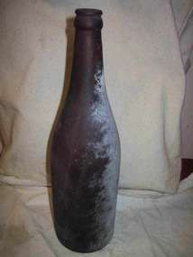 Parks Victoria - Gabo Island Lightstation
Bottle
This dark brown bottle with lip, collar, neck and gently sloping shoulder, was made by the Bottle Co. of Victoria P/L for Melbourne Bitter. The Parks Victoria inventory indicates that the bottle dates to 1925. Still brewed today, Melbourne Bitter has been made since 1904, when the Melbourne Cooperative Brewery in Abbotsford was formed by well known pub owners that included Henry Young of Young & Jacksons, and future Lord Mayor Sir Stephen Morrell. They made four beers – Abbotsford Stout (which became Abbotsford Invalid Stout in 1909), Abbots Lager, Melbourne Bitter and Abbotsford Sparkling Ale. Of those, Melbourne Bitter and the Invalid Stout remain largely unchanged and both are now brewed by the South African owned CUB. The bottle was found in the sea or on the island.Whatever their provenance, they have an association with an event or activity on Gabo Island and for this reason have second level contributory significance for their potential to yield information relating to the cultural history of the lightstation.Dark brown glass bottle, tall with gradual tapering to a narrow opening. Slightly misshapen. White coating on one side.Within a club motif, "M.B.C.V" "The property of the manufacturers. / Bottle co of Victoria Pty Ltd" "6 1925" -
 Wodonga & District Historical Society Inc
Book - Planning for Albury-Wodonga: An environmental assessment, Albury-Wodonga Development Corporation, October 1975
... heritage now and in the future. The report identified ...This report is part of an ongoing series of documents on the work of the Albury-Wodonga Development Corporation. It reflects the growing awareness of our environment and the need to conserve our heritage now and in the future. The report identified the environmental assets of the region and formed guidelines for their protection in the future.non-fiction This report is part of an ongoing series of documents on the work of the Albury-Wodonga Development Corporation. It reflects the growing awareness of our environment and the need to conserve our heritage now and in the future. The report identified the environmental assets of the region and formed guidelines for their protection in the future.albury-wodonga corporation, environmental issues, albury-wodonga development -
 Wodonga & District Historical Society Inc
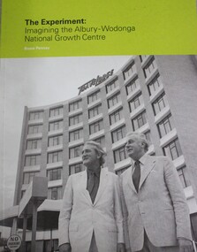
Booklet - THE EXPERIMENT : Imagining the Albury - Wodonga National Growth Centre, Bruce J Pennay, 2013
... that experiment relates to the place now and in the future. It assesses ...Introductory Abstract - "On its instigation in 1973, the Albury-Wodonga Growth Centre experiment was hailed as a novel and imaginative project. It was a "pilot scheme" that was expected to influence the urban settlement pattern in Australia. It was a "bold venture", a "brave attempt" to solve a longstanding problem. It involved three governments embarking on an "exciting adventure". This short book length catalogue essay (51 pages) provides an illustrated guide to the social history and visual arts exhibitions mounted for the 40th anniversary in 2013 of the inauguration of the Albury-Wodonga National Growth Centre experiment. The essay served as rationale and support for two council exhibitions at the Albury Library Museum and the Arts Space Wodonga in October and November 2013. The background story and the exhibitions are about place-making. They ask about the kind of place that has been made at Albury-Wodonga. How was it imagined, promoted, grown? They examine the experiment of developing Albury and Wodonga jointly and rapidly, and ask how that experiment relates to the place now and in the future. It assesses and gives a broad contextual account of the National Growth Centre experiment at Albury-Wodonga and traces important aspects of the story with emphasis on a local point of view. " Bruce Pennaynon-fictionIntroductory Abstract - "On its instigation in 1973, the Albury-Wodonga Growth Centre experiment was hailed as a novel and imaginative project. It was a "pilot scheme" that was expected to influence the urban settlement pattern in Australia. It was a "bold venture", a "brave attempt" to solve a longstanding problem. It involved three governments embarking on an "exciting adventure". This short book length catalogue essay (51 pages) provides an illustrated guide to the social history and visual arts exhibitions mounted for the 40th anniversary in 2013 of the inauguration of the Albury-Wodonga National Growth Centre experiment. The essay served as rationale and support for two council exhibitions at the Albury Library Museum and the Arts Space Wodonga in October and November 2013. The background story and the exhibitions are about place-making. They ask about the kind of place that has been made at Albury-Wodonga. How was it imagined, promoted, grown? They examine the experiment of developing Albury and Wodonga jointly and rapidly, and ask how that experiment relates to the place now and in the future. It assesses and gives a broad contextual account of the National Growth Centre experiment at Albury-Wodonga and traces important aspects of the story with emphasis on a local point of view. " Bruce Pennayalbury-wodonga, decentralisation, urban settlement australoa -
 Wodonga & District Historical Society Inc
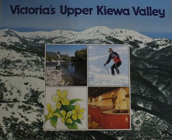
Booklet - Victoria's Upper Kiewa Valley, State Electricity Commission, C. 1984
This booklet is one of several publications from the State Electricity Commission during the period it was responsible for the running of the Kiewa Hydro Electric Scheme. It promotes tourism and depicts key features of the region in the 1980s.non-fictionThis booklet is one of several publications from the State Electricity Commission during the period it was responsible for the running of the Kiewa Hydro Electric Scheme. It promotes tourism and depicts key features of the region in the 1980s.victoria. kiewa valley, kiewa river valley (vic.) -- description and travel., kiewa hydro -
 Wodonga & District Historical Society Inc
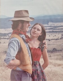
Album - Ringer's River by Des Martin - Finis
Time heals all wounds. Federation is now a fact, and Sean O'Day, managing partner in Gooloora Station can look far across the rolling country in which his children will grow up as individual members of a single nation. There is still much to be done, and the miles, and the years, and the future are calling him to the task, while the Mona Lisa-like expression of his young bride seems to say, "Yes, you have your dreams of a world to run, but I can find all my happiness in running a home for you!" FINIS.The album and images are significant because they document literature written by a prominent member of the Wodonga community. The presentation of this precis was supported by several significant district families and individuals.Ringer's River Album Coloured photo - Final Scene.des martin, many a mile, ringer's river, northeast victoria stories -
 City of Kingston
Photograph - Black and white, 20 December 1945
Cheltenham is a suburb in the City of Kingston that was originally established as a rural market gardening community. The area is bordered by Highett, Mentone and Heatherton. The market gardens, farms and paddocks have gradually been sub-divided into housing and industrial estates. The Southland shopping centre is a major feature of the area.Cheltenham was established as a rural market gardening community. The Le Page family lived in Cheltenham since 1854 when Nicholas Le Page, a tailor from the Channel Island of Guernsey, bought two acres of land on Chesterville Road near Bernard Street to establish a market garden. Over the years the Le Pages purchased more land in the area. In 1875-76 Nicholas' son Frank and his wife Mary built 'Daphne Cottage' near the corner of Bernard and Wilson Streets. n the 1940s Frank's son, Everest Le Page, bought five more lots of land in Chesterville Road from the Tuck family. The Le Pages grazed horses, ponies and cows on this land, and grew pumpkins, carrots, parsnips, onions, potatoes and cabbages. Many buildings and locations within in Cheltenham commemorate the Le Page family's contribution to the Cheltenham community.Aerial photograph taken in 1945 of the Cheltenham district within the City of Kingston. The image includes Chesterville Road, the future site of Turner Road pool (now Waves) and Highett Reserve, (top left), Jellicoe Street, Argus Street, Bernard Street, Wilson Street, the Methodist Children Homes (now Southland), McIvor Street, Goulburn Street, Nepean Highway, Jamieson Street and Barker Street (bottom left), market gardens and paddocks. In the top centre of the image, "Daphne Cottage", the home of Frank T. Le Page is visible on the corner of Bernard and Wilson Streets. Much of the land depicted in this image was owned by the Le Page family. This image is possibly from the collection of aerial photographs commissioned by the Department of Crown Lands and Survey and taken by Adastra Airways.Black and white ink: 57250 White print: VIC-170 57250 20.12.45 Run 6 PROJ. No. 5 MELB. METROP AREA Black type 10200 FTS 30' LENS 20.12.45cheltenham, market gardens, industry, le page family -
 Melbourne Legacy
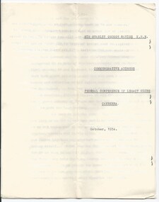
Document - Speech, Commemorative Address - Sir Stanley Savige K.B.E. Federal Conference of Legacy Clubs, Canberra, 10/1954
After the death of Stan Savige this address was given at the Canberra Conference in October 1954. It is tribute to his life. Sir Stanley Savige KBE : Commemorative Address Federal Conference of Legacy Clubs, Canberra : October 1954. On the 15th of May this year Legacy learned to its enduring sorrow of the death of its Founder, Lieut. General Stanley George Savige KBE, CB, CBE, DSO, MC, ED, for more than 30 years affectionately known to us all as Legatee Stan Savige. He was the embodiment of all those things for which Legacy stands, and each one of us who knew him and worked with him feels a great and abiding sense of personal loss. It is proper, therefore, that those of us at this Conference, the first after his passing, representative of Legacy throughout the Commonwealth, and comprising so many who were his friends, so many who knew the depth of his love for Legacy, should acknowledge our debt to our Founder and ensure, so far as we may, that the inspiration of his life and work in this Cause shall not be lost to those who follow after. It was not ordained that Stanley George Savige - should enjoy a long life, but it was to prove a life of outstanding service. Born at Morwell in Victoria some 63 years ago, he received with his brothers and sisters such education as was then available to a lad in a mining district. He had no particular opportunities of advancement, but from his early days he cherished a strong ambition to make a success of his life, and with this in view he lost no opportunity of adding to his knowledge. Always a lover of the open country, a good bushman and a fine shot, he became as a young man, a Scoutmaster with a keen following of boys. Even in those early days he attracted youth and showed undoubted promise of the quality of leadership which later was to make him famous. Opportunity came with the first World War, and he took his place as a private soldier in the original 24th Battalion AIF. Followed Gallipoli and Anzac where his marksmanship and bush craft stood him in good stead. Conscious that his early training was not sufficient to secure the promotion he desired, he set himself to enlarge it. Only a man of fine fibre and rare determination could apply himself to study on that war torn Peninsula, where our men, hitherto untested, suffered every known hardship and no man knew, from hour to hour, whether he would survive. But Savige achieved it. Himself then a Corporal he found another Corporal who was a former Schoolmaster and learned from him all that he had to teach. Savige was on his way. He was commissioned on the Field and allotted the heroic task of leading the last party off that desperate coast during the famous evacuation. In France he became the Adjutant of his Battalion and one of the best known officers in the 6th Brigade. He won the Military Cross and was mentioned in despatches. Early in 1918 he received a signal distinction, He was included in a small but distinguished band of Officers and Non-Commissioned Officers from the British and Dominion Forces most carefully selected for individual courage and proved qualities of leadership, and was sent to Persia, under the command of Major-General Dunsterville, Kipling’s famous Stalky, to assist and mobilise the friendly tribes with a view to protecting the road to India, left wide open by the withdrawal of Russia. The story of the Dunsterforce, its suffering and achievements in the face of incredible hardships and difficulties, was later to be told by Savige in his book “Stalky’s Forlorn Hope”. He emerged, finally, unscathed, despite his active participation in several of the bloodiest battles of all time, with the rank of Captain and a DSO and MC to his credit, to say nothing of three mentions in despatches. In later years, further decorations were to be conferred upon him, but I believe he valued none of these so highly as his awards for outstanding personal bravery won in the Field when he was an Officer of comparatively junior rank. Such was the man who in August 1923, at the instance of his former Commander, Major-General Sir John Gellibrand, gathered around him a handful of men who had fought and laughed with him over four well remembered years. This small band adopted the name of “Legacy”, but its purpose then was, in the main, to assist in safeguarding the interests of ex-servicemen in this country. Worthy although the case undoubtedly was, the conception and ideal which was to distinguish Legacy from all kindred post-war movements did not emerge until two years later. The torch had not been lit. Legacy had not yet found its soul. What has been achieved since then is known to you all. The Legacy ideal, unique in its conception, with no known counterpart elsewhere, is now accepted, welcomed and honoured throughout the Commonwealth and abroad. But in those early days the achievements of our Founder in the face of all manner of difficulties and frustrations are worthy of our lasting memory and thankfulness. As the source of every river lies in the hills, so must the inspiration from which stems a great conceptions of service to one’s fellow men be lofty and above reproach. Savige was the embodiment of this new expression of comradeship, as he was the central figure and driving force of the little group that sponsored it. But for his zeal, his faith and determination, it is likely that the flame, newly kindled, might have flickered and died. The idea of men returned from active service pledging for the sake of their former comradeship, their personal assistance to the widows, and above all, to the children of those who had fought beside them and paid the full price of War, was so completely new and unexpected that it was by no means readily accepted. There were no funds, no precedents to guide the new adventurers, only the clear bright flame of an ideal just envisaged, and the conviction that the Cause was unassailable. Nor were there lacking many who said that the community held no place for Legacy, that it was born of sentiment only, and would quickly pass. The scoffers are gone and one since forgotten, but the torch remains and burns brighter than ever. Down the years of Legacy there are many names deserving of honour, men from all States and all stations of life, but no name stands out in such clear and bold relief as does the name of our Founder. By his works you shall know him. He was, in truth, the Soul of Legacy. He sought no office and preferred to work as one of the team. Six years went by before he accepted the Presidency of Melbourne Club, and then only because his fellows would book no further delay. “The Spirit of Legacy is Service” - so runs the Charter, and that was Savige’s Creed. By virtue of his attainments he was called upon to take a leading part in the administration of Legacy, first within his own club and later, as Chairman of the Co-ordinating Council of Legacy in Australia. But always it was the essentially human character of the work which enthralled and upheld him, and the tasks which gave him most joy were those which brought him into close personal contact with the youngsters and their home life. Like their elders they recognised his goodwill and his leadership and responded to it. It was Savige who made possible the first camps held for the boys and girls by Melbourne Club. These were erected on his own seaside property, and were originally conducted under his personal direction and largely with the aid of funds he had collected. There was hardly an important post in his own Club that Savige did not at some time occupy and adorn. He was happiest in the company of those men with whom he had served in the field, and cherished always the comradeship born of active service which is of the essence of Legacy. He was a man of strong convictions but attentive always to another’s point of view. As a Legatee he played a leading part in bringing hope and encouragement to many a mother on whom the whole responsibility of a young family had been suddenly and tragically laid; in the attainment of the ambitions of many an orphan child, which not so long since had seemed to him or her to be mere dreams, impossible of realisation. Comfort for the bereaved, new hope for the children’s physical and educational welfare, assistance with the home, aid for the sick, money for the needy and a new courage to face a future that hitherto had held no promise, all these facets of Legacy endeavour combine to present a living and enduring memorial to the man we honour as our Founder today. Between the two World Wars in addition to establishing himself successfully in civilian life and answering the constant calls of Legacy on his energy and time, Savige maintained an active association with the Army. He was convinced that a Second AIF would one day be urgently called upon, and as a Battalion Commander he spared no effort to train the Officers under his charge during the uneasy years of peace for the trial that he felt must come. These men have all subsequently had distinguished military careers, their names are well known and many of the serve in Legacy today. When the second crisis came, Savige himself was one of the first to offer, and although his youth was spent, he proudly carried the number VX13 throughout the terrible years that followed. This time he was to command, first the 17th Australian Infantry Brigade in the first action of the Second AIF against the enemy at Barida, and subsequently at Tobruk and Derna - all famous names now. It was his patrols which gave the warning - unheeded at the time - that Rommel’s reinforcements were reaching North Africa far earlier than was expected. Then followed the grim days of Greece and Crete when the fine qualities of his leadership were put to the utmost test. I have been told by those who were closest to him it was typical of Savige that when his convoys were on the move back and were being blasted from the air by the unopposed Luftwaffe, he should sit by the side of the open road, wearing his red banded cap, to steady the morale of men who had then no chance of hitting back at the enemy. Unorthodox no doubt, but here was a man indeed. Throughout the whole campaign and later when he commended the 3rd division in New Guinea and later still when with the rank of Lieutenant-General he became a Corps Commander in New Guinea and Bouganville, it was at all times characteristic of him that he should see for himself the situation in the forward areas. He dealt personally with his subordinate commanders whenever it was possible to do so. No one says his G.S.O. 1. understood better than he did the importance of front line troops seeing their G.O.C. frequently, and knowing that he was aware of and prepared to share their hardships and dangers. He took many risks that he should not have taken, exhausted himself physically and mentally times without number, and considered himself not at all in order to secure the success of his operations. Finally, in Bouganville, he brought his campaign to a victorious conclusion and accepted the personal surrender of the Japanese Commander. Savige is known as one of Australia’s most human military leaders, but let no one believe that he did not ask and receive the utmost of his men. He trained them in a hard school but he was ever conscious of their needs and observant and thoughtful of their welfare. Fearless and untiring under conditions which brought younger men down, he asked nothing that he was not himself prepared to give and do. The close of the Second World War left him with the same brave heart; but a vitality greatly impaired. He was called up again and again to perform important national tasks, notably that of Co-ordinator of Demobilisation and Dispersal. But his interest in Legacy never flagged it was in fact more personal than ever, for under his command many junior legatees, sons of former comrades had proved themselves worthy of their Fathers in war and in peace. In the bearing and achievements of the young men of the Second A.I.F. he took a particular and justifiable pride. He applied himself to the Extension of Legacy to areas where it had not previously been practicable to operate. His record of service and close personal contact with the men of both wars made him a most welcome pioneer and many new Clubs and Groups resulted from his efforts. He founded, and I doubt whether any one else could have done so, the Club in the great Capital of our Empire. His reputation and obvious sincerity surmounted obstacles that might well have daunted lesser man. Legacy’s debt to him visibly increased. But he was ever a simple man, with a great love and understanding of his fellow men and a true Legatee at heart. Much that he did will never be known or recognised, save by those who benefitted. His service in Legacy ranged from the humble kitchen of cottage and farm to our representation in Westminster Abbey itself. A knighthood set the seal upon an outstanding career. None the less when upon the death of Field Marshall Sir Thomas Blamey, Lieut. General Sir Stanley Savige became the Patron of the Melbourne Club, he retained at his own express desire, the title of Legatee Savige, and when on that final day we bade him farewell, when the Flags he had served so well were lowered and the guns which had formed a grim final salute, it was apparent to all who had eyes to see that this great and simple man had won such a place in the hearts and affection of his fellow country men as is given to few men indeed. From the packed Cathedral, escorted by his fellow Generals, followed by men of his own Units, by Legatees and a great company of others who had cause to honour and esteem him, he made his last journey. But that is not the end. His voice and presence are lost to us but his memory and inspiration must ever remain. As he has bequeathed to the National War Memorial yonder his diaries, records and battle plans, so he has bequeathed to us his fellow Legatees his greatest achievement and his trust, Legacy itself. Never was the Torch passed by worthier hands. Now it is ours to hold it high. Whatever material memorial the future many hold for him, Legacy owes its Founder a livelier recompense. It is within our power to implement what I believe to be his greatest wish, that Legacy and its ideal of comradeship and service shall flourish and endure. Let each one of us then resolve that we shall, within our Clubs, in all tasks to which we are assigned, both great and small, keep in our minds the life and spirit of Stanley George Savige, so that we may be proud at all times to say of Legacy to those who follow after - “If you would see his memorial - Look around you”.The tribute to Stanley Savige shows how greatly he was regarded by the Legatees.Off white quarto paper with black type, address given about Stan Savige to the Canberra Conference, x 12 pages.savige, speech, obituary -
 Melbourne Legacy
Document - Speech, 'Forty Years On' Foundation Day 1967 address by Past President Brian Armstrong (H30), 1967
In September 1967 Legatee Brian Armstrong gave a speech about the first 40 years of Legacy. He mentions; 'what, in all humility, does our word 'Legacy' conjure up? To each of us, no doubt, something different, according to the the period of our service and our particular interests. To the early ones, many pictures, grave and gay, many voices, two perhaps in particular, both on the brink of a discovery. One, rather triumphant, - 'I've got it, we will call it "Legacy", but we will give instead of take, and look for nothing in return; and two years later, a quiet voice, still with us, thank heaven, "Have you ever through what the dying wish of our cobbers would have been?". This is our link. On the one hand, the still sharp memory of the lost men of Anzac France, Belgium, and the Middle East. One's own private nightmare - the expression in the eyes of the men of one's own Platoon, particularly towards the end, when they were warned for yet another operation. Men who by some miracle had survived twelve and more separate and individual hells between Gallipoli and Villers-Bretonneux and who knew full well that the Hindenberg Line was yet to come. And then we lucky ones were home again . . . Now here it was, the link, the chance to do something of real personal value, something with a real future. We do not speak a great deal of these things, nor would I do so now if I were not sure that everyone of you who wears this small badge has travelled much the same road. " He mentions the Legacy Diary belonging to Frank Meldrum, from 1925, with records on the start of Legacy. It is believed this diary was one of many documents lost in a fire. He mentions the fire destroyed the home and valuable library of Legatee Jimmy Downing. The notation H30 in red pen shows that it was part of the archive project that was trying to capture the history of Legacy. A speech given at a Legacy function that has significant information about the first forty years of Legacy.White foolscap paper with black type x 5 pages of an address by Legatee Armstrong on 26 September 1967.Handwritten H30 in red pen.history, speakers, speech, founding legatee -
 Melbourne Legacy
Document - Document, report, Staff Organisation Legacy House Present and Future. 20/7/1990, 1990
Legacy staff numbers when this document was written in 1990 were 28 full time staff and 5 part time. In 1982 there were 31 full time and 1 part time. The report discusses increasing the hours of a clerk/typist, not re-appointing a person to replace The Senior Pensions Advocate and a new appointment with computer skills. Wages increased by 53.3%. The wage increase was in line with award rates. Salaries rose by 51.8% from June1983 to April 1990. The report also discusses staff leave, work environment, staff morale and adequacy of office equipment. The future (3-5 years) was discussed in regard to pensions, welfare, housing accommodation for widows and handicapped dependants and fund raising. Location to be checked TBA There were a number of suggestions as to how to maintain current activities and not employ extra staff. The question was asked " Should we now in 1990 be encouraging our Executive Officer to make greater input on our decision making and be given greater resposibility"?Melbourne Legacy has been continually discussing and updating its programe and procedures to maintain its relevance.White foolscap paper with black type, 5 pages about staff organisation.staff, planning -
 Bendigo Historical Society Inc.
Document - ANCIENT ORDER OF FORESTERS NO. 3770 COLLECTION: NOTE
'Bendigo Advertiser, Monday 18th May 1863, p2: ' On the occasion of the first anniversary of Court Sherwood of the Ancient Order of Foresters, a ball was given by the members at the Sir Henry Barkly Hotel, Huntly on Thursday night last. There must have been at least 70 or 80 persons present, many of them from Sandhurst, White Hills, Eaglehawk and etc. Dancing commenced at nine o'clock and was vigorously kept up till the early dawn of another day came to light. Supper was served in the Court Room and the excellent repast provided by the host was duly appreciated .... from casual observation appearances would indicate that on a future day the Foresters would create a Court into which the ladies would be permitted to join in the bonds of fellowship.' Bendigo Advertiser, Thursday 2nd November 1865, p 2: 'The fourth anniversary of the establishment of Court Bendigo of the above order was celebrated on Tuesday evening at the Bendigo Hotel by a supper. There were between forty and fifty members present. The Secretary, in the course of his remarks, referred to the progress which the court had made since its establishment in October 1861. He stated that the court opened with 35 members and now numbered about 200. He congratulated the Court on having more members than any other court of the order in the district. Since it was established there had only occurred one death and at present there was only one sick member declared as receiving aid from the funds. District Secretary Holl, in responding to the toast of prosperity at the Bendigo United District of the Ancient Order of Foresters, stated that the district was first formed in 1862. At the end of the first quarter of 1862, there were eight Courts numbering 479 members. At the end of the last quarter there were twelve Courts, numbering 1278 financial members. The funds of the district in July 1862 amounted to £22/2/2d and in October 1865, the amount had increased to £570/2/8d while the Court funds amounted to £3,330/18/9d. During the last twelve months £893/8/10d had been paid for the benefit of the sick, thus showing the great benefits which were derived by becoming members of the order. Note dated 7 Oct. 1863, Court King of the Forest for P. C. R. Silk Sash £1/1/-. Signed by Jas. Thos. Holl.societies, correspondence, ancient order of foresters no. 3770 collection - note, court king of the forest, jas thos holl