Showing 22934 items
matching the yarra
-
 Melbourne Tram Museum
Book, Colour Tech Productions, "The City on the Yarra Melbourne Australia", 1985
... "The City on the Yarra Melbourne Australia" ...Full colour, 28 page on gloss paper travel souvenir guide photos, with a fold out centre fold - titled "The City on the Yarra Melbourne Australia". Features many photographs of the City of Melbourne, Phillip Island, Puffing Billy, Flinders St railway yard, Flinders St Station, Westgate bridge, the Trams of Melbourne, including some Transport Art trams. Trams: 181, 32, 497, 235, 85, 9W, 902, 22, 994, 168, 101, 225, 990 and 861?Has a price lable of $3.50 on the front cover.trams, tramways, transporting art, decorated trams, city of melbourne, travel books, souvenirs -
 Eltham District Historical Society Inc
Photograph, Fay Bridge, Ancient Eel trap on the Yarra River at Laughing Waters, Eltham - pre-dating European settlement, 6 September 2023
... Ancient Eel trap on the Yarra River at Laughing Waters ...Laughing Waters is the name for a stretch of the Yarra Valley Parklands consisting of river flats and hilly riparian bushland. With Birrarung (Yarra River) flowing through, Laughing Waters has been an important gathering place for thousands of years. For the Wurundjeri, ‘Garambi Baan’ (the name for Laughing Waters in Woi wurrung) is an important site for growing and harvesting food. Significantly, Wurundjeri iuk (eel) traps remain at Garambi Baan to this day. The Wurundjeri Woi Wurrung People take their name from the Woi wurrung language word ‘wurun’ meaning the Manna Gum (Eucalyptus viminalis) which is common along ‘Birrarung’ (Yarra River), and ‘djeri’, the grub which is found in or near the tree. Wurundjeri are the ‘Manna Gum People’ and their Ancestors have lived on this land for millennia. The site on the Yarra River near the former Morrison property Killeavey was given a language name in 2015 at the instigation of Wurundjeri Elder, Dave Wandin. Garambi Baan means “laughing waters” in the traditional language, Woi wurrung. The site at Warrandyte was rediscovered by Campbell Beardsell OAM in 2007 and is one of only a few known remaining iuk (eel) traps on Country once found the length of the Birrarung (Yarra) and the Maribyrnong. Original Indigenous aquacultural infrastructure was dismantled, taken away from sites and used to build houses, fords and roads by Europeans. The difficult and restricted access to this site is thought to be one of the reasons for its survival. The iuk trap is located within lands managed by Parks Victoria. The Narrap team in partnership with Parks Victoria and Acacia Land Management have been improving the native vegetation with a program of woody weed removal, exclusion fencing and revegetation. Importantly, the team have restored the trap’s infrastructure and have demonstrated its effectiveness.” References: Wurundjeri Woi Wurrung Cultural Heritage Aboriginal Corporation - Laughing Waters. (2023, September 3). Retrieved from https://inplace.org.au/laughing-waters/ GARAMBI BAAN LAUGHING WATERS RESIDENCY CENTRE 2020 2024 Strategic Plan, Nillumbik Shire Council (2023, September 3). Retrieved from https://www.nillumbik.vic.gov.au/files/assets/public/minutes-and-agendas/2020/09-sep/15-sep-cm/ocm.177-20-attachment-1-laughing-waters-arts-program_1.pdffay bridge collection, eel trap, laughing waters, yarra river, wurundjeri woi wurrung, garambi baan, 2023-09-06 -
 Eltham District Historical Society Inc
Photograph, Fay Bridge, Ancient Eel trap on the Yarra River at Laughing Waters, Eltham - pre-dating European settlement, 16 May 2015
... Ancient Eel trap on the Yarra River at Laughing Waters ...Laughing Waters is the name for a stretch of the Yarra Valley Parklands consisting of river flats and hilly riparian bushland. With Birrarung (Yarra River) flowing through, Laughing Waters has been an important gathering place for thousands of years. For the Wurundjeri, ‘Garambi Baan’ (the name for Laughing Waters in Woi wurrung) is an important site for growing and harvesting food. Significantly, Wurundjeri iuk (eel) traps remain at Garambi Baan to this day. The Wurundjeri Woi Wurrung People take their name from the Woi wurrung language word ‘wurun’ meaning the Manna Gum (Eucalyptus viminalis) which is common along ‘Birrarung’ (Yarra River), and ‘djeri’, the grub which is found in or near the tree. Wurundjeri are the ‘Manna Gum People’ and their Ancestors have lived on this land for millennia. The site on the Yarra River near the former Morrison property Killeavey was given a language name in 2015 at the instigation of Wurundjeri Elder, Dave Wandin. Garambi Baan means “laughing waters” in the traditional language, Woi wurrung. The site at Warrandyte was rediscovered by Campbell Beardsell OAM in 2007 and is one of only a few known remaining iuk (eel) traps on Country once found the length of the Birrarung (Yarra) and the Maribyrnong. Original Indigenous aquacultural infrastructure was dismantled, taken away from sites and used to build houses, fords and roads by Europeans. The difficult and restricted access to this site is thought to be one of the reasons for its survival. The iuk trap is located within lands managed by Parks Victoria. The Narrap team in partnership with Parks Victoria and Acacia Land Management have been improving the native vegetation with a program of woody weed removal, exclusion fencing and revegetation. Importantly, the team have restored the trap’s infrastructure and have demonstrated its effectiveness.” References: Wurundjeri Woi Wurrung Cultural Heritage Aboriginal Corporation - Laughing Waters. (2023, September 3). Retrieved from https://inplace.org.au/laughing-waters/ GARAMBI BAAN LAUGHING WATERS RESIDENCY CENTRE 2020 2024 Strategic Plan, Nillumbik Shire Council (2023, September 3). Retrieved from https://www.nillumbik.vic.gov.au/files/assets/public/minutes-and-agendas/2020/09-sep/15-sep-cm/ocm.177-20-attachment-1-laughing-waters-arts-program_1.pdffay bridge collection, 2015-05-16, eel trap, laughing waters, yarra river, wurundjeri woi wurrung, garambi baan -
 Kew Historical Society Inc
Postcard, Macauleys' Boat Shed on the River Yarra at Kew, 1907-1915
... Macauleys' Boat Shed on the River Yarra at Kew ...The Kew Historical Society's postcard collection includes views of Kew, Melbourne and Greater Melbourne as well as those including overseas scenes sent or received from Europe or the Middle East. They date from the 1890s to the 2000s. These postcards may or may not include the name of the publisher or printer. A number of the cards were published as parts of popular series. A way of dating early postcards is to identify whether the reverse was divided by a central line which became the norm after 1902 in the United Kingdom. However, other postcards produced after this date do not always conform to this print layout.The item forms part of the Laurie Bennett collection of thirty-six postcards and photographs of Kew and early Melbourne, donated to the Kew Historical Society in 1980. The postcards in the Bennett collection, like other images in the Society's holdings date from the 1890s to the present and comprehensively indicate points-of-view or scenes considered historically, aesthetically or socially significant in the period in which they were produced.Monochrome photo postcard of Macauleys' Boat Shed in Kew and its position on the Yarra at the end of Molesworth Street."KH-393. Macauley's Boat Shed, Kew. Lower Molesworth St, Donated by L. Bennett"boat sheds - kew (vic), river yarra - kew (vic), macaulay's boat shed - kew (vic), recreation - yarra river - kew (vic) -
 Kew Historical Society Inc
Photograph, River Yarra at Kew, c.1927
The River Yarra was a popular subject for photographic postcards. The postcards provide an interesting perspective of plantings on the banks of the Yarra at various periods. Small, sepia coloured real photo postcard of the River Yarra at Kew. The bird's eye view, presumably taken from Victoria Street Bridge shows the banks of the Yarra in the foreground densely planted with weeping willows. There is also canoe in the foreground. The expanse of lawn in the middle ground is that of 'Swinton', the tower of which can faintly be seen at the top centre of the view. "RIVER YARRA AT KEW / REAL PHOTO SERIES M. 2908 "real photo postcards, yarra river -- kew (vic.), postcards -- 1920s -
 Melbourne Tram Museum
Photograph - Digital Image, Kevin O'Reilly, series of three images of the Hawthorn Bridge over the Yarra, c1930, c1930's
... series of three images of the Hawthorn Bridge over the ...Image from CD (Compact Diskette for use in computers) - see Reg Item 135. A series of three images of the Hawthorn Bridge over the Yarra, c1930, during the era with problems with the bridge. See separate article for more details. Richmond 6, Richmond, Richmond 3 on the CD as original files. .1 - Looking from the south west, at the Hawthorn bridge with the temporary wooden bridge being constructed on the south side. Has the cable tram depot in the photo and part of the Burnley racing course. Temporary track on the north side of the steel bridge and crossings can be seen. .2 - Looking along Bridge Road to the east with Hawthorn Bridge in the middle of the photograph. Shows the industrial and residential areas, Hawthorn Railway Station and part of the Burnley Race course, the cable tram depot building. W class tram in Church St Hawthorn and W class tram crossing the bridge on the north side temporary track. Note the cable tram used as a shelter on the north east corner of the bridge. .3 - Looking south along River St towards Bridge Road, with the Yarra River and Hawthorn Bridge on the left side of the photograph. Shows the industry in the area at the time, wool and skin Merchants, north side of the cable depot, housing and the outlook to the river!trams, tramways, hawthorn, yarra river, burnley, richmond, hawthorn bridge -
 Melbourne Legacy
Audio - Recording, tape, "1958 ABC Anzac Obs" "The Story of the Yarra.", 1958
... "1958 ABC Anzac Obs" "The Story of the Yarra." ...The label on the tape reel says '1958 ABC Anzac OBS' in pencil. It is likely that it is one of the annual "Anzac Commemoration Ceremony for Students" events, usually held just prior to Anzac Day. The ceremony provides a valuable opportunity for students to gain an appreciation of the Anzac spirit, the significance of the Shrine and the meaning of Anzac Day. The ceremony was usually broadcast on the ABC for students that could not attend. The inscription 'The story of the Yarra' is to be confirmed when tape found again as it doesn't appear on the Media image. TBC.A record of a ceremony at the Shrine run by Legacy for students.Square cardboard box, front with black with red and white print. Rear, white background with black print. Clear plastic spool with magnetic tape.Box, Pyrox in red print. Special sound recording tape for highest frequency response. Black Magic Tape. The latest and best Recording Tape, in white print. Rear of Box, Pyrox, Black- Magic-Tape, the ultra in sound recording tape, suitable for all tape recorders, this reel contains:- Supplies available from Pyrox Ltd., 14-36 Queensberry St., Melbourne and at Sydney, in black print. Spool, clear plastic, VP785 in white ink. '1958 ABC Anzac OBS' hand written in pencil on white sticker.anzac commemoration for students, wreath laying ceremony -
 Eltham District Historical Society Inc
Negative - Photograph, Carl Walter 1831-1907, Coffer dam in the Yarra River at Anderson's Creek, 1864
... Coffer dam in the Yarra River at Anderson's Creek ...1864 photograph of the Coffer Dam in the River Yarra situated (approximately) opposite Whipstick Gully. Remains of bridge built in 1860(?) wrecked by 1863 flood in background. Reproduced page 29 of ‘Pioneers & Painters’ Gold was first discovered in this area at Andersons Creek (Warrandyte) in June 1851 by Louis Michel. Discoveries north of the Yarra did not occur until about 1854. Although it took some months for a true rush to develop it was not long before alluvial workings were being carried on in most of the Shire of Eltham. The last area in which gold was discovered was Kinglake. As the gold became harder to find, deep mining took over from alluvial diggings in the gullies. Perhaps the most extensive of the deep workings was the Diamond Creek Mine just outside the boundary of the Shire. This form of mining was continued into the 1930s. There are believed to be some mines in the area still capable of producing gold but present prices make working these uneconomical. Some gold is still found by weekend prospectors. Photo: Carl Walter 1831-1907 – inscribed on tent “C. Walter Photo” The State Library of Victoria holds over 150 photos by Carl Walter, most of which are portraits of Aboriginal natives including William Barak.This photo forms part of a collection of photographs gathered by the Shire of Eltham for their centenary project book,"Pioneers and Painters: 100 years of the Shire of Eltham" by Alan Marshall (1971). The collection of over 500 images is held in partnership between Eltham District Historical Society and Yarra Plenty Regional Library (Eltham Library) and is now formally known as 'The Shire of Eltham Pioneers Photograph Collection.' It is significant in being the first community sourced collection representing the places and people of the Shire's first one hundred years.Digital image 4 x 5 inch B&W Neg (2) Print 20 x 25 cmshire of eltham pioneers photograph collection, anderson's creek, coffer dam, floods, gold mining, other areas, pioneers and painters, warrandyte, warrandyte bridge, yarra river -
 Marysville & District Historical Society
Photograph (Item) - Black and white photograph, The "Scandinavians' - (Deserted), c1900
An early black and white photograph of The Scandinavian's Hotel and Boarding House along the Yarra Track.An early black and white photograph of The Scandinavian's Hotel and Boarding House along the Yarra Track. The Yarra Track is the former name of the gold fields road from Healesville to the Woods Point and Jordan Goldfields, in Victoria, Australia. A direct route via the Yarra River and the Great Divide was discovered by Rieck in September 1862 and became known as the Yarra Track. Early in 1863, the Victorian Government decided to construct a 193-kilometre (120 mile) road along the route. Its original width varied between 4 and 6 metres (12 and 20 feet), and was designed to accommodate horse-drawn vehicles. The Track involved the climbing of the Black Spur, descent into the Acheron Valley, and then through Marysville to the Cumberland where it followed the existing route.ARMSTRONG COLLECTION 42 STATION STREET/ SANDRINGHAM 3191/ TEL. (03) 9521 5442/ IAN M.L. ARMSTRONG OAMthe scandinavians', yarra track, healesville, wood's point, jordan goldfields, victoria, yarra river, great divide, reick, black spur, acheron valley, marysville, cumberland creek -
 Kew Historical Society Inc
Photograph - Yarra River in flood at the Willsmere Park, 1993
Willsmere Park is bounded by the the Yarra River, Green Acres Golf Club, Willow Grove and the Eastern Freeway. The land on which the park is now situated was bought by Thomas Wills at the Crown Land Sales of 1846 (Section 56). From the 1840s to the 1940s it was intensively farmed. The park is dominated by very large playing fields, while planting to the southern boundary was undertaken when the Eastern Freeway was built. It is only along the banks of the Yarra that there is any remnant native vegetation. Willsmere Park is of significance as an area of open land that remains from the flood plain that once dominated northern Kew. (Source: Kew Conservation Study, 1988)Original colour small format polaroid photograph of the Yarra River in flood at the Willsmere Park, taken on 16 September 1993."Yarra River at Willsmere Park Flooding 16.9.93"willsmere park, yarra river -- floods -- kew (vic.) -
 Melbourne Tram Museum
Postcard, Rose Stereograph Co, "The Yarra, Princes Bridge & City Skyline, Melbourne", early 1950s
... "The Yarra, Princes Bridge & City Skyline, Melbourne" ...Rose Series postcard No. P 14226 titled "The Yarra, Princes Bridge & City Skyline, Melbourne", with the Flinders St Station main concourse buildings in the view along with Princes Bridge Station, Batman Ave. Tram terminus, St Paul's Cathedral, Gas and Fuel and Ball and Welch buildings in Flinders Street. There are some 8 trams in the view including several W2 class. There is a Craven A cigarette advertisement on the south end of the station buildings. See also item 8059 for a similar photo. The 1959 extension to the T&G building in Collins Street is well in hand. Yields information about Flinders Railways Station and the Melbourne skyline, late 1950s.Postcard - printed real photograph with Rose Stereograph Co. name on the rear.trams, flinders st station, princes bridge station, st kilda road, swanston st, tramways, w2 class, batman ave, princes bridge -
 Marysville & District Historical Society
Photograph (Item) - Black and white photograph, Camp Opposite The "Scandinavians', c1900
An early black and white photograph of a camp which was opposite The Scandinavian's Hotel and Boarding House along the Yarra Track.An early black and white photograph of a camp which was opposite The Scandinavian's Hotel and Boarding House along the Yarra Track. The Yarra Track is the former name of the gold fields road from Healesville to the Woods Point and Jordan Goldfields, in Victoria, Australia. A direct route via the Yarra River and the Great Divide was discovered by Rieck in September 1862 and became known as the Yarra Track. Early in 1863, the Victorian Government decided to construct a 193-kilometre (120 mile) road along the route. Its original width varied between 4 and 6 metres (12 and 20 feet), and was designed to accommodate horse-drawn vehicles. The Track involved the climbing of the Black Spur, descent into the Acheron Valley, and then through Marysville to the Cumberland where it followed the existing route.ARMSTRONG COLLECTION 42 STATION STREET/ SANDRINGHAM 3191/ TEL. (03) 9521 5442/ IAN M.L. ARMSTRONG OAMthe scandinavians', yarra track, healesville, wood's point, jordan goldfields, victoria, yarra river, great divide, reick, black spur, acheron valley, marysville, cumberland creek -
 Yarra Glen & District Historical Society
Sepia postcards, The watering place Yarra Glen
... The watering place Yarra Glen ...Sepia photograph taken from a point just north of the bridge over the Yarra River at Yarra Glen. A small herd of cattle and a horse are on the river bank and in the water. A horse with rider stands on the bank.On back of postcard at the top "POST CARD". On the left hand side "THIS SPACE MAY BE USED FOR PRINTED OR WRITTEN MATTER”. On the right hand side "ONLY THE ADDRESS TO BE WRITTEN HERE”. In a box in the right hand corner "A HALF-PENNY STAMP TO BE PLACED HERE". Along the left hand margin "Ajax series. Printed in England". horse, yarra river, yarra glen, cattle, horse and rider, river -
 Eltham District Historical Society Inc
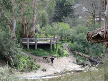
Photograph, Liz Pidgeon, View from Candlebark Park across the Yarra to the confluence of the Diamond Creek and Yarra River at Lennister Farm, 16 July 2017, 16 July 2017
... View from Candlebark Park across the Yarra to the ...Born Digitaleltham, candlebark park, yarra river, diamond creek, lennister farm -
 Marysville & District Historical Society
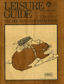
Magazine (Item) - Leisure guide, Michael Cheshire, LEISURE GUIDE THE MOUNTAINS OF MELBOURNE, 1984
A leisure guide to the mountains of Melbourne beginning in the eastern suburbs, going through the Yarra Valley and into the Great Dividing Range. This was produced by Michael Cheshire as a free publication to promote Melbourne tourism. The magazine featured Healesville, Marysville, Warburton, Eildon, Alexandra, the Upper Yarra area, and includes information on wineries in the district. It was released in the summer of 1984-1985.A leisure guide to the mountains of Melbourne beginning in the eastern suburbs, going through the Yarra Valley and into the Great Dividing Range.Summer Edition 1984-85 Featuring:/ Healesville, Marysville, Warburton, Eildon,/ Alexandra, Wineries and Upper Yarra Area.healesville, warburton, eildon, alexandra, upper yarra, marysville, victoria, australia, leisure guide, michael cheshire, blackwood holiday flats, black spur motel and caravan park, tudor lodge road house, nanda binya lodge, marysville caravan park, marysville recreation and fun park, scenic motel, the tower motel, the cumberland, cathedral restaurant, cathedral restaurant gallery, taggerty golf course, taggerty holiday units, marylyn guest house -
 Heidelberg Golf Club
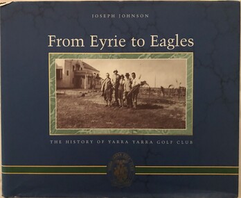
Book, Yarra Yarra Golf Club Ltd, From Eyrie to Eagles: the history of Yarra Yarra Golf Club, 1998
... From Eyrie to Eagles: the history of Yarra Yarra Golf Club ...A history of Yarra Yarra Golf Club, founded 1898.250 p., illus. (some col,)non-fictionA history of Yarra Yarra Golf Club, founded 1898.yarra yarra golf club, golf clubs - history -
 Kew Historical Society Inc
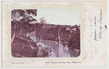
Postcard, River Yarra at Studley Park, Melbourne, 1900-04
Monochrome postcard titled lower right: “RIVER YARRA AT STUDLEY PARK, MELBOURNE”. The postcard was produced by ROBERT JOLLEY, MELB, (active 1900-1904). The photo is positioned to the left of the card and framed by an art nouveau design. A handwritten annotation on the front reads “BUT WITH THE MORNING / COOL REFLECTION CAME / BLANCHE STEPHENS”. On the reverse, there is a handwritten address in black ink to: MISS L STEPHENS / 26 WEST TERRACE / ADELAIDE. There is no division on the reverse of the postcard, dating it to before 1905. It lacks a postage stamp and postmark. Monochrome postcard of the River Yarra in Studley Park. The view is of the Yarra and its banks, with Kew on the left and Abbotsford on the right, as it appeared in the years 1900-1904. On the Abbotsford side of the river, there are a number of weeping willows lining the banks and houses on the hillside. The Studley Park side of the river includes some remnant vegetation and meandering walking tracks. Three very small figures are sitting on the Kew side. "RIVER YARRA AT STUDLEY PARK, MELBOURNE"river yarra -- kew (vic.), postcards -- kew, postcards -- studley park, robert jolley -
 Canterbury History Group
Document - Railway Communication with Doncaster, Kew and the Kew Asylum and Yarra Bend Asylum Lands, J.Kemp Government Printer, 1908
... Railway Communication with Doncaster, Kew and the Kew ...Report from the Parliamentary Standing Committee on Railways, on the question of Railway Communication with Doncaster, Kew, and the Kew Asylum and Yarra Bend Asylum Lands.canterbury, doncaster, kew, yarra bend asylum, kew asylum, victorian railways, outer circle railway, railways standing committee, victorian government -
![Junction of the Rivers Yarra and Watt, Near Healesville / [by] Nicholas Caire, circa 1876](/media/collectors/550653872162f11fb04854aa/items/577740e5d0cdd10a5c0de011/item-media/57774153d0cdd10a5c0e0662/item-fit-380x285.jpg) Kew Historical Society Inc
Kew Historical Society IncPhotograph, Anglo-Australasian Photographic Company, Junction of the Rivers Yarra and Watt, Near Healesville, c. 1876
... Junction of the Rivers Yarra and Watt, Near Healesville ...Nicholas Caire was born on Guernsey in the Channel Islands in 1837. He arrived in Adelaide with his parents in about 1860. In 1867, following photographic journeys in Gippsland, he opened a studio in Adelaide. From 1870 to 1876 he lived and worked in Talbot in Central Victoria. In 1876 he purchased T. F. Chuck's studios in the Royal Arcade Melbourne. In 1885, following the introduction of dry plate photography, he began a series of landscape series, which were commercially successful. As a photographer, he travelled extensively through Victoria, photographing places few of his contemporaries had previously seen. He died in 1918. Reference: Jack Cato, 'Caire, Nicholas John (1837–1918)', Australian Dictionary of Biography.An original, rare photograph from the series 'Views of Victoria: General Series' by the photographer, Nicholas Caire (1837-1918). The series of 60 photographs that comprise the series was issued c. 1876 and reinforced a neo-Romantic view of the Australian landscape to which a growing nationalist movement would respond. Nicholas Caire was active as a photographer in Australia from 1858 until his death in 1918. His vision of the Australian bush and pioneer life had a counterpart in the works of Henry Lawson and other nationalist poets, authors and painters.Albumen Silver Photograph, mounted on Board.printed in ink on support l.c.: JUNCTION OF THE RIVERS YARRA AND WATT, NEAR HEALESVILLE. / COPYRIGHT REGISTERED. printed in ink on support reverse c.: VIEWS OF VICTORIA. / (GENERAL SERIES.) / No. 3. / JUNCTION OF THE RIVERS YARRA AND WATT, NEAR HEALESVILLE / The junction is situated about 3 miles from Healesville, and 35 miles from the mouth of the Yarra. The souces / of the Watt are to be found at the head of the Black Spur, and, being fed by a number of creeks and springs, its / waters gain considerable force for several miles before joining those of the Yarra. The "Old Bridge," at the junction, / is the name given to this crossing-place, which has been partly swept away by late floods. The depth of the Yarra here / is from 15 to 20 feet; that of the Watt, about 10 feet. printed in ink on support reverse l.c.l.: J.W. FORBES, Agent, printed in ink on support reverse l.c.: ANGLO-AUSTRALASIAN PHOTOGRAPHIC COMPANY, MELBOURNE. printed in ink on support reverse l.c.r.: 10 Temple Court, Collins Street West.nicholas caire (1837-1918), yarra river, watt river, bridge, wooden bridge, healesville -
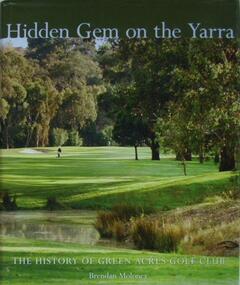 Kew Historical Society Inc
Book - Volume, Hidden Gem on the Yarra: The history of the Green Acres Golf Club / by Brendan Moloney
... Hidden Gem on the Yarra: The history of the Green Acres ...History of Greenacres Golf Clubnon-fictiongreen acres golf club, golf clubs - kew (vic) -
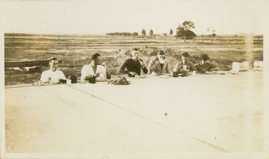 Kew Historical Society Inc
Photograph - Victorian Canoe Club, Breakfast on wharf after camping on lower Yarra, 1930
Canoeing on the River Yarra at Melbourne was an important and widespread recreational pursuit for Melbournians, especially in the first half of the twentieth century. The Victorian Canoe Club was formed in 1912 at a meeting in Melbourne and its first committee elected in the same year. Records indicate that the Club continued into at least the 1950s .The photos in this album are historically and socially significant as a record of recreational activities in the first half of the twentieth century. A number of photographs in the album provide views of sections of the Yarra, as well as areas in regional Victoria, that may otherwise be unavailable.One of 12 sepia [faded] photographs of members of the Victorian Canoe Club. This photo shows the six club members on the trip eating breakfast on a wharf in a location on the Lower Yarra, before canoeing on to Port Phillip Bay. "Breakfast on wharf after camping on lower Yarra"victorian canoe club, river yarra, travel -- 1930s, canoeing, lower yarra -
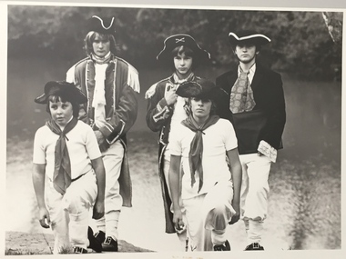
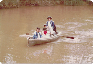 Kew Historical Society Inc
Photograph - Historic re-enactment during the Festival of Kew, 1978
At the 1978 Festival of Kew, a number of organisations, including the City of Kew, the Kew Historical Society, Trinity Boys Grammar School and local Girl Guides participated in a re-enactment of the expedition of the party of Charles Grimes in surveying the Yarra River as far as Kew in February 1803. The location for the event was Yarra Bend Park near the Studley Park Boat House. The event was organised by the Kew Historical Society. The re-enactment was captured by a number of amateur photographers as well as by a photographer from the local Progress Press.Local communities select events to commemorate according to their shared history and values. Commemorations of colonial exploration were popular with local historical groups such as the Kew Historical Society in the twentieth century. In re-enacting events such as the Grimes survey of the Yarra, students from a local school were encouraged to take on specific roles, including play-acting individuals involved in the survey party as well as members of the local Wurundjeri People. The photographs, taken by amateur and professional photographers, represent a period in time when the dominant values were those shared by the descendants of European settlers in Victoria. Original colour photographic positive showing six boys from Trinity Grammar School in a boat on the Yarra at Studley Park in a re-enactment of the survey party of Charles Grimes of February 1803.Annotated on reverse: "TRINITY BOYS AS GRIMES PARTY ON YARRA / 1978 FESTIVAL"kew historical society, trinity grammar school, kew girl guides, city of kew, yarra river, charles grimes, collins expedition, wurundjeri people, yarra bend park, colonial surveys, historic re-enactments, festival of kew, kew festival -
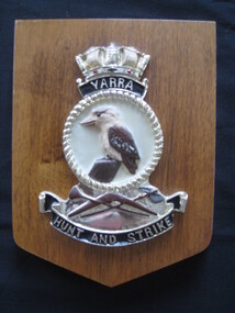 Lilydale RSL Sub Branch
Plaque - Ship's Plaque, HMAS Yarra
HMAS Yarra badge mounted on wooden plaque. Badge depicts crown with sails above the word "Yarra". Below which is a Kookaburra in a circle above a boomerang with crossed horn and axe (medieval), above the word "Hunt and Strike"Yarra/ Hunt and Strike -
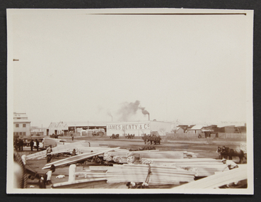 Mission to Seafarers Victoria
Photograph - Photograph, Sepia, Mr and Mrs Gurney Goldsmith, Landing lumber on the South Side of the Yarra - On the Wharf, 1906
... Landing lumber on the South Side of the Yarra - On the ...Small monochrome photograph, lightly faded depicting lumber on the wharf with the James Henty and Co store in the backgroundWritten in pencil on verso "12"james henty & co, docks, lumber, timber, wood, wharf, yarra river -
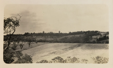 Kew Historical Society Inc
Photograph - Yarra Bend and Kew Asylum, 1924
Henry Beater Christian (1886-1962) , was a descendant of one of the earliest settler families in Kew. Employed at the Kew Asylum as a 'public servant', he was a skilled amateur photographer, photographing numerous scenes in Kew and on his travels around Victoria. The majority of his photographs date from 1916 to 1929. His finest photographs are housed in two photograph albums. Digital copy of a photograph from page 6 of the 47-page photograph album containing 261 gelatinous silver images, loaned by Diane Washfold with permission given to digitise and hold a copy in our collection. This is a photograph of the grounds of the Yarra Bend Asylum looking across the Yarra River to the Kew Asylum on the horizon. The photograph predates the 1929 closure of the Yarra Bend Asylum. "Yarra Rvr / Kew"henry beater christian (1886-1962), landscape photography, kew (vic.) — yarra river, christian-washfold collection, photograph albums, yarra bend asylum, kew asylum, yarra bend park -
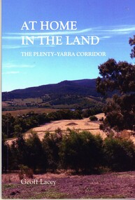 Greensborough Historical Society
Book, Geoff Lacey, At home in the land: the Plenty-Yarra corridor, 2021
... At home in the land: the Plenty-Yarra corridor ...111 p., paperback, col. photographs, mapsnon-fictionindigenous plants, indigenous fauna, plenty river, yarra river -
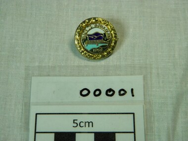 Yarra Glen & District Historical Society
Badges, Stokes, c.1958
The 'Back to Yarra Glen' event was held on the Australia day weekend, 1959. Badge is circular with filigree work around the outer rim. The inner circle has a picture of the Yarra Glen bridge over the light blue river with the dark blue mountains in the background and green river bank in the foreground. There are green trees at each end of the gold bridge. The sky is white. On the green grass foreground is the date 1959. Above the mountains are the words 'Back to Yarra Glen'. The diameter is 2.5 centimetres. It is made of pressed metal, maybe brass, with gold colouring around the outer edge and back. On the front of the badge "Back to Yarra Glen" is across the top and "1959" on the bottom. "Stokes Melb" is on the back -
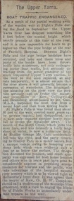 Kew Historical Society Inc
Newspaper - Article, The Upper Yarra: boat traffic endangered, 1918-20
... The Upper Yarra: boat traffic endangered ...An item of ephemera relating to tourism and recreation on the Yarra River in Melbourne in the first half of the twentieth century.An item from a large collection assembled by the Christian and Washfold families of Kew, including photographs, postcards, and ephemera. Many of the items in the Christian-Washfold Collection relate to the Yarra River and its use as as a recreational resource. Numerous items in the collection are historically important in that they are rare and often unique records of vanished locations or past recreational activities.Article describing the effects of the partial collapse of the weir at Dight’s Falls and its impact on water levels between Kew, Fairfield, and Heidelberg. The article is undated however as it describes Cr Harry Tompkins as Mayor of Kew it must date to the years 1918-20.christian-washfold collection, river yarra -- recreation, dight's falls -
 Kew Historical Society Inc
Photograph, Standard Newspapers, Charles Grimes Re-enactment, Yarra River, 1978
The party of the British surveyor Charles Grimes were the first Europeans to view the River Yarra, as it was later to be named. Members of the party reached the area now known as Studley Park in 1803. This local re-enactment commemorated 175 years since that event.Charles Grimes, Re-enactment, Yarra River, Kew, 1978. Inscription on reverse: "Trinity Grammar School students taking part in Grimes' journey up the Yarra, 1803. Re-enactment Historical Society Kew contribution to the 1978 Festival of Kew."charles grimes re-enactment, trinity grammar school, cr whiting -- mayors -- kew (vic.), yarra river, andrew allen, kew historical society