Showing 868 items matching "tides"
-
 Orbost & District Historical Society
book, 1924
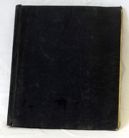
Friendly Societies were founded in the Australian Colonies in the mid-19th Century by immigrants from England who had been members in Societies which dated back to the 18th Century. Like all working people these immigrants experienced sickness, accidents, unemployment, death and burial. They needed help of like fellows to tide their families over these times. So they formed a branch of one of the Friendly Societies back in the mother country. The idea was to make fixed contributions to a fund and when they were off work they would receive a payment. When they died funeral benefits would be paid and the widow and children would be cared for. It was a form of local insurance for hard times. This item was used in a time of 'look after yourself' as the Colonial Governments did not provide pensions or benefits. This item reflects those times.An account book for M.U.I.O.O.F. (Manchester Unity Independent Order of Oddfellows ). It has a dark blue fabric cover. It contains hand-written accounts.m.u.i.o.o.f. friendly-society accounts-book -
 Orbost & District Historical Society
book, 1922
Friendly Societies were founded in the Australian Colonies in the mid-19th Century by immigrants from England who had been members in Societies which dated back to the 18th Century. Like all working people these immigrants experienced sickness, accidents, unemployment, death and burial. They needed help of like fellows to tide their families over these times. So they formed a branch of one of the Friendly Societies back in the mother country. The idea was to make fixed contributions to a fund and when they were off work they would receive a payment. When they died funeral benefits would be paid and the widow and children would be cared for. It was a form of local insurance for hard times. This item was used in a time of 'look after yourself' as the Colonial Governments did not provide pensions or benefits and reflects those times.A very large cash book with a blue fabric cover , a brown spine and edges. -
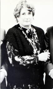 Williamstown High School
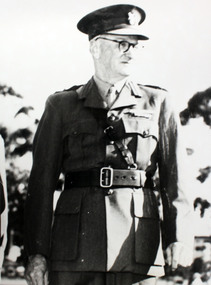
1982 - Principal Gwen Alexander
Copy of black and white photograph mounted on board. Accompanied by a quote.On back of photograph: Mrs Gwen Alexander, Principal 1982-3? Quote reads: '1982 a curriculum day and weekend conference at Lorne were the beginnings of many changes, one of which was Goal Based Assessment. Students had a wider choice of subjects, the new Home Group system began.... Students will experience a richer, more rewarding and more enjoyable life at school. I am very proud to be the first woman principal of Williamstown High School.' Mrs Gwen Alexander High Tide 1982. williamstown high school, 1982, principals -
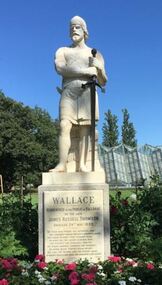 City of Ballarat
Artwork, other - Public Artwork, Percival Ball, Sir William Wallace by Percival Ball, 1889
The imposing white marble statue of William Wallace by Percival Ball stands approximately 8 feet tall with helmet and sward. The statue is mounted on a granite base with a marble plaque inscribed in praise of William Wallace, the Scottish warrior famous for leading the defeat of English forces at the Battle of Stirling Bridge in 1297. The artwork is located in the Botanic Gardens in Ballarat, Victoria and can be seen upon entry from the main gates. Sculpted by Percival Ball of Melbourne and unveiled in 1889, the statue was funded by a £3000 bequest to the gardens by James Russell Thomson, a Scottish miner who made his fortune during the Victorian gold rush. It was intended as a tribute to Thomson’s Scottish origins. The front the statue bears an inscription from Robert Burns’ 1785 sentimental poem ‘The Cotter’s Saturday Night’, which also lauds Wallace as a noble patriot and hero.The artwork is of historic and aesthetic significance to the people of BallaratWhite marble statue of William Wallace on plinthWALLACE Bequeathed to the public of Ballarat by the late James Russell Thomson unveiled 24th May 1889. "Oh thou! who poured the patriotic tide that streamed through Wallace's undaunted heart, who dared to nobly stem tyrannic pride, Or nobly die, the second glorious part, (The patriot's God, peculiarly thou art. His friend, inspirer, guardian, and reward!) Oh never, never, Scotia's realm desert; But still the patriot, and the patriot bard, in bright succession raise her ornament and guard;" (Burns)sir william wallace, statues, statuary pavillion, botanical gardens, lake wendouree, william wallace statue, charles summer, percival ball -
 Melbourne Tram Museum
Newspaper, The Age, The Sun, The Herald, The Pubic transport Mess - "Rail loop may turn cash tide, Jan. 1980
Set of four newspaper clippings regarding the Transport Pageant including photos of the events. .1 - The Age, 29-1-1980 - The Pubic transport Mess - "Rail loop may turn cash tide" with a graph of train and tram passengers per year, loss of passengers. Includes a photo of the TMSV horse tram and Ballarat 40 with a note that it had broken down. Written by Gerry Carman as Transport Reporter. .2 - The Sun, 29-1-1980 - "A tram link to history" featuring a photo of Alison Mercer patting the TMSV horse tram horse - Blossom. .3 - The Herald 28-1-1980 - "Remember when" with a photo of people enjoying a model Puffing Billy locomotive and Ethel Smith patting Blossom. .4 - The Sun 21-1-1980 - detailing the event programme - see also Reg Item 5573.trams, tramways, australia day, mmtb, melbourne, tramcars, pageant, melbourne pageant, public transport, passengers, tmsv, btps -
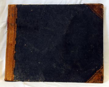
 Orbost & District Historical Society
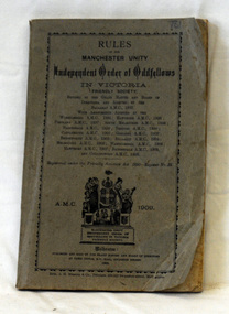
book, Rules of the Manchester Unity, 1909
This item probably belonged to Albert Coulson a farmer of Brodribb. Friendly Societies were founded in the Australian Colonies in the mid-19th Century by immigrants from England who had been members in Societies which dated back to the 18th Century. Like all working people these immigrants experienced sickness, accidents, unemployment, death and burial. They needed help of like fellows to tide their families over these times. So they formed a branch of one of the Friendly Societies back in the mother country. The idea was to make fixed contributions to a fund and when they were off work they would receive a payment. When they died funeral benefits would be paid and the widow and children would be cared for. It was a form of local insurance for hard times. This book was used in a time of 'look after yourself' as the Colonial Governments did not provide pensions or benefits. This item reflects those times.A small grey book with the Manchester Unity Independent Order of Oddfellows. At the bottom of the cover in black print is the society's Coat of Arms showing a woman holding a child with two children beside her. On the right is a woman holding an anchor with her arm around a woman holding a cross. There is an images of a group of people holding a scroll beside a reclining lion."Brother A.H.J. Coulto was initiated a member of the Loyal Orbost Lodge 8 Sept 1909" -
 Orbost & District Historical Society
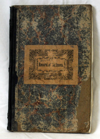
book, Record of Sickness, 1900
This book was used by the Orbost Manchester United Independent Order of Oddfellows. Friendly Societies were founded in the Australian Colonies in the mid-19th Century by immigrants from England who had been members in Societies which dated back to the 18th Century. Like all working people these immigrants experienced sickness, accidents, unemployment, death and burial. They needed help of like fellows to tide their families over these times. So they formed a branch of one of the Friendly Societies back in the mother country. The idea was to make fixed contributions to a fund and when they were off work they would receive a payment. When they died funeral benefits would be paid and the widow and children would be cared for. It was a form of local insurance for hard times. This record book was created in a time of 'look after yourself' as the Colonial Governments did not provide pensions or benefits. This item reflects those times.A hard back book with a red and blue mottled cover and a dark blue spine. On the front cover is a large brown rectangular label with "Record of Sickness" in black print inside an ornate black frame.on label - handwritten above title - "M.U.I.O.O.F."m.u.i.o.o.f. friendly-societies book-keeping -
 Flagstaff Hill Maritime Museum and Village
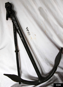
Functional object - Anchor, Early to mid 20th century
Anchors are used to stop boats from moving and today are usually made of metal, and they are made to catch the ocean floor (the seabed). There are two main types of anchors: temporary and permanent. A permanent anchor is called a mooring block and is not easily moved. A temporary anchor can be moved and is carried on the boat. When people talk about anchors, they are usually thinking about temporary anchors. An anchor works by either weight (mass) or shape. Shape is more important to temporary anchors, and design is very important. Anchors must resist wind and tide, and also the up-and-down movement of waves. The subject item is a foundry produced item made specifically for marine use, at present there is no history or manufacturing provenance currently available as the item is unmarked.The subject item at this time cannot be associated with an historical event, person or place, provenance is unknown, item is believed to have been produced in the first half of the 20th century by an unknown manufacture and its design is known as the "Kedge Admirality" pattern.Kedge Admirality design anchor metal with double bent hook & Halibut. Stock, eye, loop and shackle at top of anchor. Stock held in position with pin. Anchor painted black.Nonewarrnambool, flagstaff-hill, flagstaff-hill-maritime-museum, maritime-museum, shipwreck-coast, flagstaff-hill-maritime-village, ships anchor, marine eqipment -
 Flagstaff Hill Maritime Museum and Village
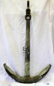
Functional object - Anchor, Early to mid 20th century
Anchors are used to stop boats from moving and today are usually made of metal, and they are made to catch the ocean floor (the seabed). There are two main types of anchors: temporary and permanent. A permanent anchor is called a mooring block and is not easily moved. A temporary anchor can be moved and is carried on the boat. When people talk about anchors, they are usually thinking about temporary anchors. An anchor works by either weight (mass) or shape. Shape is more important to temporary anchors, and design is very important. Anchors must resist wind and tide, and also the up-and-down movement of waves. The subject item is a foundry produced item made specifically for marine use, at present there is no history or manufacturing provenance currently available as the item is unmarked.The subject item at this time cannot be associated with an historical event, person or place, provenance is unknown, item is believed to have been produced in the first half of the 20th century by an unknown manufacture and its design is known as the "Kedge Admirality" pattern.Anchor, Kedge Admirality design galvanised metal with shackle and rope hole at top of anchor Halibut is missing (bar at top) and two curved flat pointed metal hooks at the base of the anchor.Nonewarrnambool, flagstaff-hill, flagstaff-hill-maritime-museum, maritime-museum, shipwreck-coast, flagstaff-hill-maritime-village, ships anchor, marine eqipment -
 Williamstown High School
Mr C. Brook 1947-56
Mr C. Brook was the Principal of Williamstown High School from 1947-56Copy of a black and white photograph, mounted on board. Accompanied by a caption.Caption reads: Mr C. Brook, Headmaster from 1947-1956. "the most important objectives of education must be to discipline the mind, to teach the student how to acquire knowledge, to instil in him the desire to become an even more useful member of society. The Government of the State has provided free education to the matriculation stage, liberal grants for books, travelling allowances and in certain cases maintenance allowances. These grants together with a large number of scholarships, have made secondary education available to all." High Tide 1952. Enrolment in 1951 was 780 students.williamstown high school, headmaster, 1947, 1948, 1949, 1950, 1951, 1952, 1953, 1954, 1955, 1956, mr c. brook -
 Orbost & District Historical Society
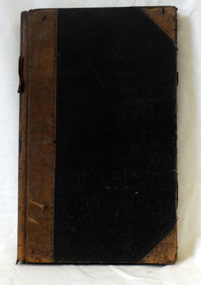
book, 1936
This book contains M.U.I.O.O.F. (Manchester Unity Independent Order Of Oddfellows) accounts of the Orbost group. Friendly Societies were founded in the Australian Colonies in the mid-19th Century by immigrants from England who had been members in Societies which dated back to the 18th Century. Like all working people these immigrants experienced sickness, accidents, unemployment, death and burial. They needed help of like fellows to tide their families over these times. So they formed a branch of one of the Friendly Societies back in the mother country. The idea was to make fixed contributions to a fund and when they were off work they would receive a payment. When they died funeral benefits would be paid and the widow and children would be cared for. It was a form of local insurance for hard times. This account book was used in a a time of 'look after yourself' as the Colonial Governments did not provide pensions or benefits. This item reflects those times.A hard back book with a blue cover and a brown spine.on spine on red flock in gold lettering "NIGHT BOOK:m.u.i.o.o.f.friendly-societies -
 Federation University Historical Collection
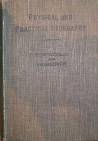
Book, Physical and Practical Geography For Secondary Schools, c1935, c1935
... tides ...Green cloth hardcovered book of 384 pages. Includes photographic and line illustrations.signed inside cover "K.H. Wilkie 1935"geography, k.h. wilkie, marie bentivoglio, f.f. fiederich, solar system, atmosphere, barometer, wind, rainfall, temperature, climate, climatic zones, rivers, glaciers, plains and plateau, mountains, volcanoes, deserts, oodnadatta, campel transport, lakes, lake frome, shorelines, oceans, tides, latitude and longtitude -
 Victorian Aboriginal Corporation for Languages
Book, Aboriginal Community Elders Service et al, Aboriginal elders' voices : stories of the "tide of history" : Victorian Indigenous elders' life stories &? oral histories, 2003
This book is a collection of Victorian Indigenous Elders' life stories and oral histories. The Elders share their stories in an attempt to ensure that both sides of Australia's history are finally heard. These stories tell of cultural resistance on missions, of defying assimilation laws, of forever moving around to save children from the welfare. They document the development of both fringe and urban communities and work in the Aboriginal rights movement. They clarify the ways in which these experiences have affected the individual authors along with the indigenous population in general. Also included in the book is a brief history and analysis of the legislation, policies, attitudes and strategies that have affected the lives of the authors and their families since colonisation. This aspect provides an historical perspective, encouraging a deeper understanding of the Elders' stories. Reconciliation can only eventuate with an understanding gained from hearing and including the voices of Indigenous Australians. Contents: The writing team Indigenous elders: keepers of knowledge; custodians of land and culture Aboriginal lands Missions and reserves Growing up running from the welfare /? Aunty Olive Jackson Respecting our Elders /? Aunty Lola James If your mother didn't tell you, then your grandmother did! /? Uncles Les Stewart Don't dwell on trouble /? Aunty Audrey Critch There are my people /? Aunty Gwen Nelson We were all cousins, more or less /? Aunty Iris Lovett-Gardiner Aboriginality is about culture, not colour /? Aunty Dianne Phillips Take up the opportunities we struggled to make /? Aunty Frances Gallagher Home /? Aunty Eileen Alberts We were supposed to forget our Aboriginality /? Aunty Gwen Garoni Not enough heart to say sorry? /? Uncle Brian Kennewell-Taylor Learning from indigenous elders: Keeping the traditions, keeping the culture strong; Since time immemorial; Invasion: the tide ran red; The flood of legislation; Stolen children; Cultural resistance: holding on to children traditions and land; Organised resistance: a movement is born; The 1950s: community resistance to race laws; The price of assimilation; The Aboriginal rights movement; After the flood: self-determination; Turning the tide Bibliography Appendix. Cultural custodianship: developing an indigenous methodology.maps, colour illustrations, b&w photographswiradjuri, victorian indigenous elders, oral histories, yorta yorta, dja dja wurrung, language maps, victorian missions and reserves, lake condah, framlingham, coranderrk, ramahyuck, lake tyers, wahgunyah, cummeragunja, moonahcullah, balranald, ebenezer, maloga, acheron -
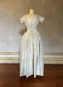 Kew Historical Society Inc
Clothing - Grey silk wedding dress, 1842
This wedding gown was worn by Mary Ann Lawrence at 8.00am on 5 January 1842 at St John's Church, Launceston, when she married Francis Henty. The couple were to catch the tide on their way to Portland two hours later. Francis Henty was the youngest son of Thomas Henty, who with his family, their retainers and property moved to the Australian colonies between 1829 and 1832. In 1834, Francis’ older brother, Edward, sailed from Launceston in Van Diemen’s Land to what was to become Portland in the western part of Port Phillip District [Victoria]. Francis, together with the first flock of Merino sheep [in Victoria], followed some months later. The first and second generations of the Henty family established vast pastoral properties in the Western part of the Port Phillip District. Francis Henty managed ‘Merino Downs’ near Casterton, while also living in his retirement at ‘Field Place' in Kew. The Henty Collection of nineteenth and twentieth century clothing, including outerwear and underwear, was collected, stored and exhibited over time by female family members descended from Francis and Mary Ann Henty. During the twentieth century, items from the collection were modelled in two fashion parades by various descendants [1937, 1959]. The items in the collection are historically and aesthetically significant, with provenance provided by oral and written tradition within or held by the family. A number of the items in the collection are very rare survivors, and provide researchers with the evidence needed to reconstruct the lives of notable women in the Port Phillip District [later Victoria] during the nineteenth and early twentieth century.Mary Ann Lawrence's grey silk wedding gown has a v-line waist and a partly smocked bodice. It is lined with muslin throughout. It has hand-tatted cotton lace and handmade piping around the neck and bodice and pleated short sleeves. There was originally trimming on the skirt which was removed at a later date. Orange blossom made of chamois and tiny coiled springs originally decorated the neckline. The outfit was complemented by a bonnet to which a Limerick lace veil was attached. MEASUREMENTS (MM): GIRTH - Neck 914, Chest 812.8, Waist 660.4, Cuff 330.2, Hem circumference 3200.4. VERTICAL - Front neck to hem 1270, Front waist to hem 1016, Back neck to hem 1320.8, Back waist to hem 1041.4, Sleeve length 114.3. HORIZONTAL - Neck to sleeve head 50.8, Chest back 406.4, Underarm to underarm 406.4.mary ann lawrence, francis henty, wedding dresses, fashion -- 1840s, women's clothing -
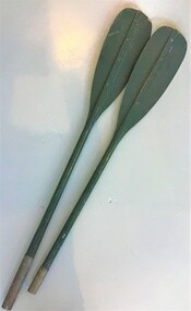 Queenscliffe Maritime Museum
Functional object - Paddles
In 1960 seventy-four commandos from 2 Commando Company left Point Lonsdale at 6pm on February 17 to cross The Rip in an exercise raid on the Portsea officer school. Shortly after departing, a strong tide caught the raiding party and pushed them out to sea through The Rip, where 10-metre waves capsized many of the kayaks and amphibious vehicles. Many of the men were picked up by larger rescue boats, only to be overturned once again in the heavy seas. Warrant Officer George Drakopolous and the driver of his amphibious DUKW, Private Eddie Meyer, both drowned as their vehicle sank. Eight of the commandos were rescued in Bass Strait after being picked up by an Italian ship, the Toscana. Commando Roger Wood helped others board the Toscana safely but was washed off a rope ladder by a monster wave and into the sea. His body was never found. It remains one of Australia's least-known peacetime military tragedies.One of the later disasters around the Rip between Points Nepean and Lonsdale. The 'Queenscliffe' lifeboat turned out to search for survivors without success Paddles from a Mk3 foldaboat used in ill fated commando training exercise in 1960the rip disaster, kayaks, oars -
 Bendigo Military Museum
Photograph - RASvy Surveyors in the field, c1950s – 1960s
This is a set of 1photographs of surveyors in the field measuring distances using chains, taking observations using theodolites and operating electric distance measurement equipment. They were probably employed in establishing mapping and geodetic control operations or the surveyors may have been in training. The photos were most likely taken in the 1950s and 1960s. Photos .1P to .6P feature personnel setting up geodetic survey chaining equipment to measure distances. The surveyor in Photo .5P is LTCOL Howard Angus Johnson MBE who served from 1936 to 1954. The RA Svy surveyor in photos .7P to .12P were using a theodolite to take angular measurements. They were usually supported by an observer who recording their readings on a booking form. The surveyor in Photo .10P and .11P is LTCOL Jorge Gruszka, who served from 1955 to 1985. He was CO of the Army Survey Regiment from 1982 to 1985. The surveyor in photo .13P is cutting an identification blaze on a tree using a hammer and chisel. The tellurometer in Photos .14P to .16P was a MRA1 microwave Electronic Distance Measuring instrument (EDM) introduced in 1958. It and later models were man-portable systems that improved geodetic survey efficiencies for rapid network extension and densification replacing triangulation with EDM and theodolite traverse sometimes using Bilby Towers to extend line lengths. The surveyor with the slouch hat is Colonel James ‘Jim’ Leslie Stedman, who served from 1941 to 1978. He was Director of Military Survey from 1975 to 1978 and was appointed as Colonel Commandant (honorary appointment, Retd) of the Royal Australian Survey Corps from 1978 to 1983. Jim Stedman is demonstrating EDM equipment.This is a set of 17 photographs of surveyors in the field measuring distances using chains, taking observations using theodolites and operating electric distance measurement (EDM) equipment. c1950s – 1960s. The photographs were printed on photographic paper and are part of the Army Survey Regiment’s Collection. The photographs were scanned at 300 dpi. .1) - Photo, black & white, c1950s, unidentified personnel using geodetic survey chaining equipment. .2) to .4) - Photo, black & white, c1950s, geodetic survey chaining equipment. .5) – Photo, black & white, c1950s, Jim Stedman using geodetic survey chaining equipment to measure distances. .6) - Photo, black & white, c1950s, Unidentified personnel geodetic survey chaining equipment. .7) – Photo, black & white, mounted on card, c1950s. Unidentified surveyor undertaking observations on a coral reef using a theodolite. .8) – Photo, black & white, c1950, unidentified surveyor undertaking observations with a Tavistock theodolite. .9) – Photo, black & white, mounted on green card, c1950s. Unidentified surveyor undertaking observations using a plane table. .10) – Photo, black & white, c1955, Jorge Gruszka undertaking observations with a theodolite. 7/55 Basic Survey Course Balcombe. .11) – Photo, black & white, c1950s, Jorge Gruszka undertaking observations with a theodolite. .12) – Photo, black & white, c1946-1948, unidentified surveyor undertaking observations with a theodolite to gain control for the mapping of the Snowy Mountain Diversion Scheme. .13) – Photo, black & white, c1950s, unidentified surveyor cutting a blaze in a tree. .14) and .15) – Photo, black & white, c1960s, Jim Stedman demonstrating EDM equipment. .16) – Photo, black & white, c1960s, L to R: Jim Stedman (probably) and unidentified surveyor demonstrating EDM equipment. .17) – Photo, black & white, 1956, Operation Cutlass - Surveyors SPR W. Crane and J.A. Campbell undertaking observations with a theodolite in extreme conditions..1P on back - First Order Chaining Equipment .2P on back - First Order Chaining Equipment .3P on back - Full catenary 1800 – 1960 replaced by EDM .4P on back - First Order Chaining Equipment .5P on back - H.A. Johnson, Benambra baseline? 1st Order Chaining .6P on back - Chaining .7P on front - Difficult observing conditions especially when the tide is in. The station is sighted (sic) on a coral reef. .8P on back - Tavistock. .10P on back of duplicate in Photo Folder 14 – George (sic) Gruszka 7/55 Basic Survey Course Balcomme (sic) 1955/56 .14P and .15P on back - Jim Stedman demonstrating early EDM equipment.royal australian survey corps, rasvy, army survey regiment, army svy regt, fortuna, asr, surveying -
 Federation University Historical Collection
Book, Northern Territory of South Australia Report Resulting from the Explorations by the Government Geologist, 1906, 1906
Pale blue soft covered geological and general report. It includes a chapter of Bathurst Island and Melville Island, Primitive Methhods of Chinese Mining, Early Days of Mining in the Northern Territory Images include sandbank at low tide, Douglas River, Granite at Union Hill, Night Cliff, East Point, union hill, zapopan gold mine Brook's Creek, Blow Gold Mine Yam Creek, Daly River Copper Mine, Mount Ellison Copper Mine, Point Charles Lighthouse, Blacks Camp near Point Charles Lighthouse, The Venture Stranded on a Daly River Sandbank, Hyland Bay Natives, Boabab Trees at Blunder Bay, The Wai Hoi, Mouth of Fitzmaurice River, Point Blaze Natives, Fort Hill and Old Gulnare Jetty Port Darwin, Large Anthill, Daly RIver Natives, Wargie Natives, L.C.E. Gee, H.Y.L. Brown, H. Basedow. F.J. Williamson, Aboriginal crew (Pedro, Peter, Tobatchie, Bubs, Loman), Henry Roberts, Schollert's Grave It also includes a large folder Geological Map of the North-Western District Northern Territory of South Australia. northern territory of south australia, geology, l. o'loughlin, douglas river, bathurst island, melville island, apsley straight, chinese, aboriginal -
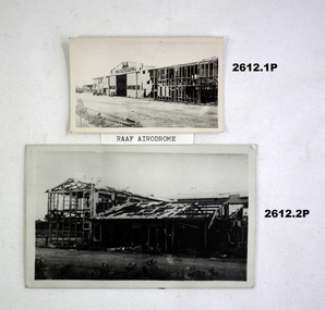 Bendigo Military Museum
Photograph - PHOTOGRAPHS, DARWIN WW2, 1942
Collection of black & white photographs with typed captions detailing some of the destruction of buildings, shipping & equipment during & after the first attack on Darwin by the Japanese (Feb 19th 1942)..1) Bombed building. .2) Bombed building. .3) Bombed hangar. .4) Bombed store building. .5) Water tower with aircraft in background. .6) Bombed 2 storey building. .7) Sunken ship with 2 ships in background. .8) Scrapped aeroplane. .9) Small steam train..1) On back: More RAAF Drome damage. .2) On back: RAAF Drome. No opposition than couple of Wirraways & Kittyhawks. .3) On back: Hangar RAAF Drome when the Nips finished. .4) On back: First bomb on Post Office Darwin. .5) On back: Jap plane (pos zero) flying around water tower, Darwin loco before arrival of Spitfires at Darwin. .6) On back: Bob Dyers bank Darwin. .7) On back: Neptuna on side alongside wharf & 2 ships on mud at low tide Darwin Harbour. .8) On back: Scrap heap Bathelor field. .9) On back: Fly used on wharf at Darwin before Japs bombed wharf & sunk Neptuna standing there.photography-photographs, military history - war damage, passchendaele barracks trust -
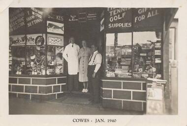 Phillip Island and District Historical Society Inc.
Photograph, 1940
Nine photographs from a collection of 33 donated by Leonie Brennan. Photographs belonged to Edward (Ted) Sands, hairdresser.Photograph 215-01 Black & White photograph of 3 people standing in front of Mr Anderson's shop in Cowes. Miss D Winson?? Mr O S Kennedy & Mr R Anderson. Photograph 215-02 Black & White photograph of landing cranes on the Cowes pier. Cowes foreshore and mature trees in background. Photograph 215-03 Black & White photograph of the early construction of Phillip Island bridge viewed from Phillip Island. Shows the base structure of the first bridge. Photograph 215-04 Black & White photograph of the Newhaven - San Remo Punt on the shore on the Phillip Island side. Photograph 215-05 Black & White photograph of Edward (Ted) Sands standing in front of R Anderson's shop in Cowes. Photograph 215-06 Black & White photograph of a koala in tree in front of shed and water tanks. Photograph 215-07 Black & White photograph of the Isle of Wight Hotel showing front footpath and shop next door. Photograph 215-08 Black & White Photograph of the Cowes beach at low tide, showing mature trees on the foreshore and boats in the water. Photograph 215-09 Black & White Photograph of Mr R Anderson's Shop in Cowes.All photographs except for one marked on front with "Cowes" the month and year 1940.cowes shop phillip island, mr anderson, mr o s kennedy, mr edward (ted) sands, isle of wight hotel phillip island, cowes pier phillip island, cowes beach phillip island, newhaven-san remo punt, wildlife - koala, koala cowes phillip island, phillip island first bridge, leonie brennan -
 Orbost & District Historical Society
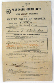
certificate, 30th January 1903
This certificate was issued on January 30, 1903 to Captain Alan Richardson by the Marine Board of Victoria entitling her to carry 25 passengers and only 10 passengers when engaged in towage service. Two children under 12 years of age to be reckoned as one passenger. The penalty of 20 pounds would be levied if these limits were exceeded. the certificate was valid until 21st July 1903. The original Paddle Steamer Curlip was built by Sam Richardson and his sons Mark, Albert and Frank, at their sawmill at Tabbara, a pioneering settlement on the Brodribb River, a tributary of the Snowy River. Curlip's keel was laid on 14th October 1889 and PS Curlip was launched in 1890. The Paddle Steamer Curlip was designed to travel up and down the Snowy and Brodribb Rivers with essential supplies from coastal ketches and schooners, that plied their trade up and down the coast between Melbourne, Sydney and Tasmania. The Curlip regularly towed one or two barges and up to five barges loaded with local farming produce and timber for the thriving cities, that was loaded offshore or in the Snowy River estuary, tide and depth permitting, on to the trading vessels.This item is associated with the P.S. Curlip and the Richardson family, early Orbost pioneers.A paper passenger certificate for a river steam ship.Details are handwritten in black and red ink.curlip-p.s. certificate-passenger richardson -
Queenscliffe Maritime Museum
Geological specimen - Copper ore
The Empress of the Sea was a magnificent three masted, square rigged, wooden sailing clipper ship built in Boston, USA. The Empress of the Sea is historically and archaeologically significant as it was one of Donald Mackay's famous wooden clipper ships, i.e. representative of a particular design or type. It was also associated with both the Black Ball and White Star Lines of Australian Packets, which carried thousands of immigrants from Britain to Australia. The Empress of the Sea caught fire at Queenscliff at 4 am on 19 December 1861. When the officer of the watch attempted to extinguish the fire they found fire pump handles missing and buckets ineffective. Fire became out of control and the ship was sailed from anchorage and ran ashore at Point Nepean. Ship rolled over onto starboard side by force of the tide and the shifting ballast. The port side was burnt to the copper. The Empress of the Sea lies in 5 metres (16 feet) to 7 metres (23 feet) of water, 700 metres (2,297 feet) offshore from Nepean Bay, Port Phillip. The site covers an area 150 metres (492 feet) long and 50 metres (164 feet) wide. The bow lies towards the south-west. Piece of copper ore, possibly part of ships cargo, recovered from the site of the Empress of the Sea shipwrecked in Nepean Bay 1861shipwrecks, nepean bay, empress of the sea -
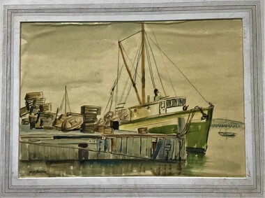 Queenscliffe Maritime Museum
Painting - Framed Watercolour, Fishermen's Pier Queenscliff
Queenscliff’s first pier, then known as the Fishermen’s Pier, was completed in 1857. It was not until some thirty years later that the second Steamer Pier was constructed adjacent to the former and periodically extended from the mid to late 1880s to cope with the demand in pleasure bay steamer services. The last of these extensions was to provide a dog-leg construction and the extant shelter shed. 1960 witnessed the demolition of the original Fishermen’s Pier - by this time having been extended in the late nineteenth and early twentieth centuries to the equivalent length of the Steamer Pier - and saw the relocation of its 1926-29 lifeboat house to the Steamer Pier, now Queenscliff Pier. The mid to late 2000s saw Queenscliff Harbour undergo large-scale redevelopment in order to deepen its waters for pleasure craft and increase its berths to over 300. This was met with strong community opposition, largely with concerns for neighbourhood character and perceived cause for gentrification its stakeholders would impart. With early construction estimates of $20 million dollars, this figure had almost doubled upon realisation. (Lovell Chen Architects. ‘Individual Property Citation’, Queenscliffe Heritage Study, 2009.) (Freya Mitchell, ‘Queenscliff residents fight a tide of development sweeping the historic town’ ABC radio, 15 April 2005).Fishermen's Pier Watercolour painting of Fishermen's Pier in Queenscliffwatercolour, fishermen's pier, queenscliff -
 Flagstaff Hill Maritime Museum and Village
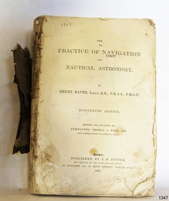
Book - Technical Reference, Henry Raper, Lieut. R.N, The Practice of Navigation and Nautical Astronomy, 1891
This technical textbook is the nineteenth edition of the book by Henry Raper, Lieutenant in the Royal Navy with awards that include F.R.A.S. (Fellow of the Royal Astronomical Society) and F.R.G.S. (Friend of the Royal Geographical Society). The book is dedicated in honour of Rear-Admiral Sir Francis Beaufort K.C.B., Hydrographer to the Admiralty. He was awarded the title K.C.B. (King's Commander) as a Member of the Order of Bath, an order of British Chivalry, The book was first published in 1840 and soon became a resource for navigation students. It includes topics on nautical navigation, astronomy, navigation charts, calculations and mathematical tables, time, tides, ships, longitude, and position at sea. Thomas A. Hull, who revised and expanded this edition, was a Commander in the Royal Navy and had previously been Superintendent of Admiralty Charts used for navigation worldwide by seamen from many walks of life. The publisher, J D Potter of London, was at that time the sole agent for the Admiralty Charts produced by the Royal Navy. Printer Spottswoode and Co.,. was established by William Strachan in 1738. In 1819 his nephews A and R Spottswoode took over the business and bought premises in New-Street Square and Shoe Lane. In 1850 over 200 workers were employed by the firm. and five years later the business became Spottswoode & Co. Andrew Spottswoode invented the Spottswoode Press.This technical book was very popular as a textbook for students of maritime navigation, written and updated by members of the British Royal Navy and relied upon for accurate advice and information. The first edition was published in 1840, this edition was updated, expanded and published in 1891 when ports around the world were filling with travellers, merchants and business people. Title: The Practice of Navigation and Nautical Astronomy Author: Henry Raper, Lieut, R.N., F.R.A.S., F.R.G.S. Nineteenth Edition, revised and enlarged by Commander Thomas A. Hull, R.N., Late Superintendant of Admiralty Charts Dedication: To Rear-Admiral Sir Francis Beaufort K.C.B. Publisher: J D Potter, London, sole agent for the sale of Admiralty Charts Printer: Spottswoode and Co. New-Street Square, London Date: 1891 Small leather hardcover book with gold embossed text and lines on the spine. The Dedication in the book is as follows: - "To Rear-Admiral Sir Francis Beaufort K.C.B. Hydrographer to the Admiralty. Sir, The eminent station which you occupy in the naval scientific world renders it highly gratifying to me to dedicate the following Work to you as a testimony of my regard and esteem; while the general accordance of my views on the subject with those of your more experienced judgement, gives me the greater confidence in laying my labours before the Public. I have the honour to be, Sir, Your obedient servant, HENRY RAPER"flagstaff hill maritime museum, maritime museum, shipwreck coast, flagstaff hill, warrnambool, flagstaff hill maritime village, book, navigation, nautical astronomy, hydrography, nautical charts, nautical navigation, astronomical navigation, admiralty charts, henry raper, thomas a. hull, royal navy, j d potter, royal astronomical society, royal geographical society, calculations, mathematical tables, longitude, latitude, nautical time, location at sea, position at sea, maritime, practical navigation, spottswoode and co., sir francis beaufort, k.c.b., rear-admiral sir francis beaufort, hydrographer to the admiralty, scientific book, naval science -
Ringwood and District Historical Society
Documents, Clocktower Theatre Company, Files and correspondence from the Clocktower Theatre Co., Ringwood. 1971-1974, 1971-1974
Files and correspondence from the Clocktower Theatre Co. Qty 16 folders.; 1. Minutes >1979. Lever Arch File. Foolscap. Mottled hard cover.; 2. Minutes Feb 1973-Dec-1976. R. Kent. Forms 2E Corrections. Foolscap. Buff folder.; 3. Rehearsal Schedules and minutes 1971-1977. 2-Ring binder. Hard black cover.; 4. Inwards correspondence. Green folder. Foolscap.; 5. Fundraising 1971-1979. Buff folder. Red printing, foolscap.; 6. Play Licences 1973-1979. Regal flat file, green, foolscap.; 7. List of members. Typed, buff, foolscap.; 8. List of members 1976. Yellow folder, foolscap. Tingwell, Chas. workshop.; 9. Constitution. Buff folder, foolscap.; 10. Application Form. Application for Grants. Australian Council for the Arts.; 11. Completed Application Forms (for membership) 1971-1973.Buff, foolscap.; 12. Applications for membership and membership lists. Buff, foolscap.; 13. Newsletters. Buff, foolscap.; 14. Account Book 1972-1979. Hard black cover, 9-Money Column. Clocktower Theatre Co. Foolscap. Size 33.5 x 20 x 1.8cm.; 15. Expenses and stamps. Embassy Exercise Book. Red cover quarto. Refer #3641.; 16. Plays including: The Rattle of a Stick; September Tide; & Misc. Buff folder, foolscap. -
 Mission to Seafarers Victoria
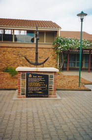
Photograph - Photograph, colour, c. 2001
Opened by His Excellency Sir Eric Neal AC CVO on 30 September 2001, the Memorial is located in City Park, Port Pirie, South Australia. The monument commemorates those who were lost at sea while serving with the Merchant Navy. Mr Noel Smith, a resident of Port Pirie, former Merchant Navy seaman and Port Pirie tugboat officer designed the memorial, found the anchor located on the top of the memorial during a dredging operation in a creek near the Nystar plant and wrote the poem inscribed on the main plaque. Front Inscription Lost Ones They live in the curl of the breaking wave, They sing when the sea winds blow, They lay not confined in a land locked grave, Nor in dim dark depths below. Do you hear them laugh in the rippling tide, Call free in the ocean breeze ? Do you see them soar where great gulls glide At peace with the fearsome seas ? They live still in the hearts of those who wait Held strong in the bonds of love 'Til their souls unite and congregate In God`s great harbour above. Noel Smith Merchant Seaman For those who were lost to the depths of the sea Emma Hindmarsh Left Side Inscription Memorial unveiled by His Excellency Sir Eric Neal AC CVO Governor of South Australia and His Worship the Mayor Ken Madigan Port Pirie Regional Council Memorial blessed and consecrated by Right Reverend Garry Weatherill Bishop of Willochra 30 September 2001Colour photograph of the memorial made of an anchor on a bricks and stones base with a black marble plaque titled The Lost Ones. The logo of the Merchant Navy, MN, on the top left corner of the plaque.merchant navy, mn, port pirie, memorial -
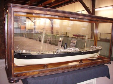 Seaworks Maritime Museum
Shipbuilders model, SS ARGUS (1889-1907) - Steel steamship built by Palmers & Co., at Newcastle on Tyne for Archibald Currie & Partners, Melbourne, SS Argus, 1889-1907
Steel screw steamer launched 1889 at Newcastle on Tyne by Palmers & Co., built for Archibald Currie and Partners - the Currie Line of Melbourne. Gross tonnage: 2,792, Length: 99.06m (325'). Width: 12.3m (40.3'). Triple expansion steam engines producing 363 nhp. Avge speed 11 knots. Coal consumption 26 ½ tons per 24 hours. Steel hull, one funnel, two masts, barque rig. • 1889: Argus launched. Worked in the Australia to India trade, passengers, goods and horses. • 1891 July: While taking coal from Newcastle to Singapore, ran onto sunken rock in Gaspar Strait (in Indonesia). Watertight bulkheads held, got to Singapore, was repaired for two months, 60,000 Straits dollars (about £12,000). • 1895 July: While taking 400 horses to Colombo, ran onto reef near Somerset, North Queensland. holed, water in two compartments. 400 tons coal jettisoned, finally got off in spring tides. • 1901 Feb: During Boer War took Victorian contingent, 5th Mounted Rifles, fromMelbourne to Durban and Cape Town, with 500 horses. • 1901 Dec: Took horses for Boer War from Brisbane to Durban. • 1903 31 July: Leaving Sydney for Calcutta with 86 horses, 20 passengers including the Sultan of Johore, was rammed by the incoming steamer Mildura (on the wrong side of the channel). Argus's side plating was cut from deck to below waterline, had to be beached on Goat Island to prevent sinking. Refloated 2 August and repaired. • 1905: Argus sold to the Japanese shipping company, Osaka Shosen Kaisha. Renamed Giran Maru. • 1907 11 Sept: Wrecked in Soya Strait, between Hokkaido & Sakhalin Island.Built for Archibald Currie & Partners, Melbourne. Carried passengers between Australia and India and between western and eastern Australia.Large ship builder's model in glass case -
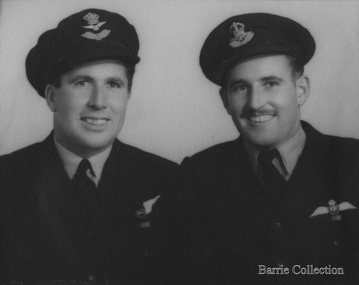 Melton City Libraries
Photograph, Jim (James) and William (Horace) Barrie, Unknown, c.1940
In 1939 when World War 11 erupted Jim and Horace enlisted in the RAAF Jim to become a pilot and Horace a navigator. James Edward Barrie enlisted in the RAAF on 21st June 1941, aged 19 years. He was sent to Canada and then later to England to become a Spitfire Pilot. Half way through the War he returned to Australia to be sent north to fight the Japanese. At one stage he had to bail out over the Pacific after his engine had failed. Fortunately, he had time to radio his position before he abandoned his Spitfire. He dropped his boot out to determine how far below the water was, parachuted down inflated his dinghy and waited to be rescued. He was picked up very quickly by a rescue crew just as a heavy fog descended, or he may never have been found. He lost many of his mates in that Squadron in the Pacific, it was a particularly vital time for the Allies and these boys played a major part in turning the tide against the Japanese. This information has been taken from the writings of Mary Robinson, sister of Jim. My parents Bon and Edna Barrie spoke about this incident leaving a vivid impression in my mind as a young child. Jim is mentioned in the book Two Steps to Tokyo. A Story of the RAAF in the Trobriand and Admiralty Islands by Gordon Powell Chaplain, RAAF. After the war Jim returned to Darlingsford. In 1953 he married Wilma Ryan of Yarram. He continued in the family farming tradition obtaining a Soldier Settlement Block at Shelford. Jim regularly attended the ANZAC day march to the Shrine. He died in August 2004 This account has been compiled by his niece Wendy Barrie Sons of Charles (Ernie) and Jessie Barrie of Darlingsford Meltonlocal identities -
 Mission to Seafarers Victoria
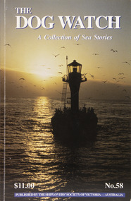
Journal (item) - Periodicals-Annual, Shiplovers' Society of Victoria, The Annual Dog Watch
This journal provides the reader with glimpses of the adventures and hardships of a seaman's life. Many of the stories are of sailing ships.Contributes to our knowledge of the importance of shipping and places on record those stories of the sea which would otherwise be lost.Contents Editorial - Harrow Morgan - 5 Captain Angel’s Daughter - Anne Morgan - 6 Australia’s Last Lightships - Ross Meredith - 17 Duyfken Sets Sail — 394 years on - Nick Burningham - 25 Episodes in King Sound - Capt. John Abernethy - 33 Time and Tide - Lynn Sunderland - 38 Explosives in the Port of Melbourne - Cliff Gibson - 39 A Small Misunderstanding - ‘Flinders Bar’ - 51 Mr Bligh’s Bad Health - Ian Campbell - 55 Shipmates - Bernie Sprunt - 64 A Life at Sea - Capt. Ted Daubeny -65 Ketch Hands are Impervious - Noel Smith - Noel Smith - 73 The Devil’s Handwork - R N Thiele - 83 The Beginning of Herzogin Cecilie’s Last Round of Voyage — 1935 - Pamela Eriksson - 85 A Scrap of Flotsam - Esther Hardware - 93 The Waning Skills of Shipwrights - Arthur E Woodley - 96 Trouble in Paradise - Capt. R Jolly - 101 History & Heritage HMAS Castlemaine — the first 60 years - Peter J Williams - 104 The Days of ‘Whack’ and ‘Slush’ - Sir James Bissett - 108 An Unusual Lectern - George C Hogben SSV - 111 Book Reviews - - 112sailing ships, steamships, shipping, seafaring life, shiplovers' society of victoria, dog watch -
 Flagstaff Hill Maritime Museum and Village
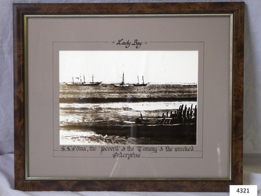
Photograph - Picture, Lady Bay Ships at anchor, after November 1850
The photograph shows sailing ships and a wreck in Lady Bay, Warrnambool. Lady Bay was once a very busy port of trade in Warrnambool and was also called the Port of Warrnambool or Warrnambool Harbour. THE “ENTERPRISE” 1847-1850 The wooden, two-masted schooner Enterprise was built in New Zealand in 1847 and registered in Melbourne, Australia. The Enterprise carried cargos of agricultural produce and other commodities for trade between the ports of the Colony. On September 14, 1850, the Enterprise was at anchor in Lady Bay under its Master, James Gardiner Caughtt, loaded with a cargo of wheat and potatoes. A strong south-easterly wind caused the vessel to drag on its only anchor and the rudder was lost. The gale-force wind blew it sideways and it became grounded. A local indigenous man, Buckawall, braved the rough sea to take a line from the shore to the Enterprise. All five members of the crew were able to make it safely to land. The Enterprise was wrecked. The Enterprise wreck was in an area called Tramway Jetty in Lady Bay. Since then the area became the location of the Lady Bay Hotel and now, in 2019, it is in the grounds of the Deep Blue Apartments. In fact, with the constantly changing coastline through built-up sand, the wreck site is now apparently under the No 2 Caravan Park on Pertobe Road, perhaps 150 metres from the high tide. Its location was found by Ian McKiggan (leader of the various searches in the 1980s for the legendary Mahogany Ship). DIFFERENTIATING the New Zealand Schooner “Enterprise” from John Fawkner’s “Enterprize“ Dr Murray Johns, Melbourne, says in his article The Mahogany Ship Story “… As I documented in 1985, the Warrnambool wreck was of an entirely different ship, also called Enterprize [with the spelling ‘Enterprise’], but built in New Zealand in 1847. Fawkner’s ship had already been sold to Captain Sullivan in 1845 and was wrecked on the Richmond Pier in northern New South Wales early in 1847. “ - (further details are in NOTES: and FHMV documents) This photograph is significant for its association with the screw steamer SS Edina, heritage listed on the Victorian Heritage Database VHR S199. She had endeared herself to the people of Port Phillip Bay as a passenger ferry, part of their own history and culture. She played a significant role in the Crimean War, the American Civil War and the gold rush in New Zealand. She also served western Victoria for many years in her cargo and passenger runs. The SS Edina is famous for being the longest serving screw steamer in the world. After spending her first nine years overseas she arrived in Melbourne and her work included running the essential service of transporting cargo and passengers between Melbourne and the western Victoria ports of Warrnambool, Port Fairy and Portland. The photograph is also significant for its association wreck of the schooner Enterprise, also listed on the Victorian Heritage Listed VHR S238, being a New Zealand built but Australian owned coastal trader. The wreck was also significant for its association with indigenous hero Buckawall who saved the lives of the five crew on board. Photograph titled "Lady Bay" depicts Lady Bay, Warrnambool, with vessels including SS Edina, the Peveril and the Tommy, with remains of the 1850 wreck of the schooner Enterprise in foreground. Titled, in hand written script, “”Lady Bay”, “S.S. ‘Edina’, the ‘Perevil’ & the ‘Tommy’ & the wrecked "Enterprise” Written in pencil on back “Council”flagstaff hill, warrnambool, shipwrecked-coast, flagstaff-hill, flagstaff-hill-maritime-museum, maritime-museum, shipwreck-coast, flagstaff-hill-maritime-village, enterprize, enterprise, port of warrnambool, warrnambool harbour, peveril, tommy, ss edina, pleasure steamer edina, warrnambool steam packet company, david hay, james gardiner caught, tramway jetty, buckawall, lady bay, steam ship, travel, trade, coastal trader, edina, dinah, cargo run, shipping, victoria, port phillip bay, john watson, edward byam, indigenous hero, indigenous rescue -
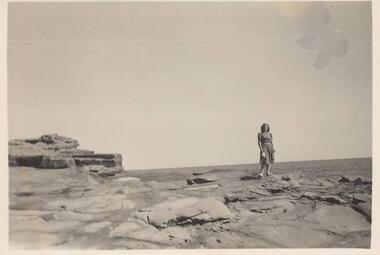 Phillip Island and District Historical Society Inc.
Photographs, 1939
A group of 26 photographs collected by Ralph Andrews, father of Michele Spencer donor. Michele sent the photographs with a covering letter explaining how her father had kept to collection for many years so she felt they should go to a good home for safe keeping. Michele's husband's uncle, Frank Spencer, was the Post Master at Cowes for many years.219-01. Photograph of lady standing on rocks at San Remo 219-02. Photograph of rocks at Back Beach San Remo 219-03. Photograph of rocks at Back Beach San Remo 219-04. Photograph of the San Remo Camping Ground 219-05. Photograph of Merv Horkings in tent at San Remo Camping Ground 219-06. Photograph of Merv Horkings in tent at San Remo Camping Ground 219-07. Photograph of three men on the beach at San Remo 219-08. Photograph of coastal scene San Remo at low tide 219-09. Photograph of rocks at San Remo 219-10. Photograph of shoreline with trees at San Remo 219-11. Photograph of Jetty at San Remo with boats moored 219-12. Photograph of the back view of a man on the beach at San Remo 219-13. Photograph of coastal scene looking towards the eastern entrance to Westernport 219-14. Photograph of Merv Horkings standing outside a tent at the San Remo Camping Ground 219-15. Photograph of people standing and sitting on rocks at San Remo 219-16. Photograph of coastal scene looking towards the eastern entrance to Westernport 219-17. Photograph of foreshore with rocks and lonely tree on land at San Remo 219-18. Photograph taken from San Remo looking towards Newhaven with breakwater. 219-19. Photograph of rock platform at San Remo 219-20. Photograph of coastal scene at San Remo 219-21. Photograph of the breakwater at San Remo 219-22. Photograph of a man sitting on the beach at San Remo with groyns on the foreshore 219-23. Photograph of coastal scene at San Remo 219-24. Photograph of coastal scene at San Remo 219-25. Photograph of the San Remo Punt 219-26. Photograph of a vehicle waiting for the Punt to travel across to Newhavensan remo coastline, san remo punt, newhaven-san remo punt, san remo camping ground, ralph andrews, frank spencer, michele spencer