Showing 171 items matching "township - hotels"
-
 Lakes Entrance Historical Society
Photograph, Fish, Marie, 2002c
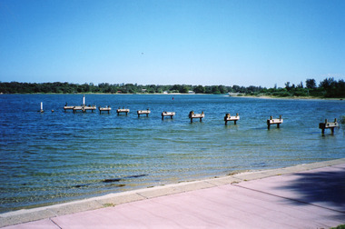
The Club Hotel jetty used to be the mooring for Wyanga Winery tourist launch 'TheCorque'Colour photograph of the piers left during the dismantling of the Club Hotel Jetty, also part of the Club spit footpath beside the lake in the foreground. Lakes Entrance Victoriajetties, waterfront, township -
 Lakes Entrance Historical Society
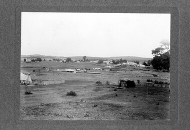
Photograph - New Works, 1910c
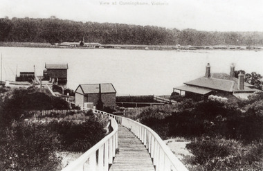
Also black and white copy 12.5 x 18 cm with smear of purple ink in top left hand corner, purchased from Helen ClothierTinted black and white photograph showing boardwalk from New Works Jetty over the sand dunes with small shed on jetty, small one room Boole Poole school on right of boardwalk and harbour master's house on right. Club Hotel on opposite foreshore and town on far right. Kalimna escarpment in background, at Lakes Entrance, Victoria.View of Cunninghame Victoriaboardwalk, waterways, ships and shipping, township, topography -
 Linton and District Historical Society Inc
Photograph, Early Pitfield, Showing Bridge, Store and Hotel
... Pitfield Hotel Pitfield Township Buncle's Flat Emu Inn Buildings ...Identified by inscription on the back of the photograph as "Early Pitfield", and the buildings as "Matthew Hamilton Baird's . . . hotel & store". Information from Joan Hunt (see 'Pitfield/Kaleno' file) says the Emu Inn or Pitfield Hotel was at Pitfield/Wardy Yallock township on the road from Skipton to Geelong. Part of this area - foreground, to the left, was called "Buncle's Flat", named after John Buncle, a carpenter who lived in a cottage there with his family. An early timber inn on the Wardy Yallock Creek was owned first by Peter Hardie and then by Edward Langhorne/John McNamara in the 1840s and a mail run from Geelong was established to it in 1846. Matthew Hamilton Baird was the lessee or owner from 1852, and Benjamin Fernald from about 1860. In 1853, the nearby store, at that time owned by William Whitecross, caught fire. The fire spread to the hotel and both buildings were destroyed. The hotel was replaced by the brick or stone building seen in the photograph.Small black and white copy of original photograph which shows trees, fencing and farm buildings in foreground, and in the background a large stone or brick building plus smaller timber buildings (dwellings?) situated along a roadway. On the right of the photograph the road goes over a large bridge of timber construction.On back of photograph: "Early Pitfield showing Matthew Hamilton Baird's store (stone?) & hotel & store".pitfield bridge, pitfield hotel, pitfield township, buncle's flat, emu inn, buildings, hotels, matthew hamilton baird, benjamin fernald, edward langhorne, john mcnamara, william whitecross -
 Lakes Entrance Historical Society
Photograph - Lakes Entrance, 1945c
Two tinted copies, one 8.5 x 13.5 and one 6.5 x 9Black and white postcard showing town, twelve memorial cypress trees and spotting tower on foreshore, post office wharf, boat harbour, Club Hotel at west end of esplanade with five palm trees opposite, causeway to Bullock Island, highway bridge over North Arm, highway up to Jemmys Point, Rigby, Fraser and Flannagan Island's towards Metung. Lakes Entrance VictoriaLakes Entrance islands, aerial photograph, waterways, township -
 Linton and District Historical Society Inc
Photograph, Piggoreet Township
... house, hotels and churches. Piggoreet Township Copy of original ...Piggoreet Township developed very quickly after gold was discovered in the Springdallah area (at that time called Spindella) in the 1850s. By the early 1860s the township had a population in the hundreds, as well as shops, a school, a police station and court house, hotels and churches.Copy of original photograph which shows roads, buildings, general layout of the former township at Piggoreet.piggoreet township -
 Ringwood and District Historical Society
Photograph, James Handforth, father of Katherine, wife of Louis Herry, formerly of Walhalla and Cheshire, England. c1880
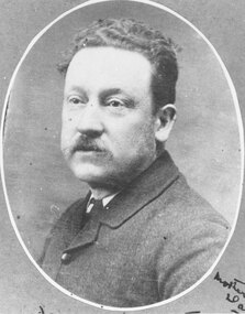
Black and white photographWritten on backing sheet, "James Handforth, father of Katherine, wife of Louis Herry, formerly of Walhalla and Cheshire, England". From the Place of Many Eagles book, "Louis was born in Purdu, France, in 1855, and came to Ringwood from Walhalla in 1887 and erected a weatherboard house and shop opposite the Club Hotel, using a Miner's Right to secure the land. When he arrived, Louis was a married man with three children, Leopold (1882), Marie (1884), John (1886). He had married Kate Handforth at Walhalla in 1879. In later years Elizabeth, Minellia, Louis and Denise were born. Kate's father was known as the midwife of the Gippsiand township because he had once been a fourth year medical student in England, but earnt a living as a goldbuyer in Victoria. Marie Herry would grow up remembering her grandfather calling sometimes at Ringwood; he would bring the children jubilee Mixture to eat and he carried a revolver in his pocket. Often he would play the violin while Marie would stepdance on the kitchen table." -
 Lakes Entrance Historical Society
Photograph - Kalimna, Bulmer H D, 1940c
Black and white photograph of aerial view of Kalimna escarpment, Princes Highway, road to Kalimna Hotel, scattering of buildings including Gainsborough House, in distance is North Arm bridge, footbridge to undeveloped Bullock Island with rock groynes in place. Part of eastern pier of entrance at Lakes Entrance, Victoria. waterways, topography, township, bridges -
 Clunes Museum
Photograph, CIRCA 1862
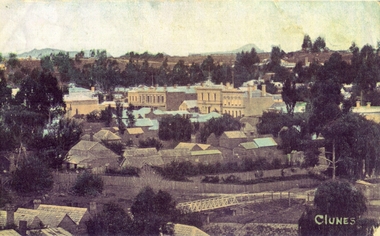
PHOTOGRAPH TAKEN BEFORE 1862 BECAUSE HALL BETWEEN CLUB HOTEL AND ES&A BANK WAS REMOVED IN 1862 TO BECOME CHURCH OF ENGLAND SUNDAY SCHOOL. CALEDONIAN BRIDGE IN FOREGROUND1. COLOURISED COPY OF PHOTOGRAPH OF CLUNES TOWNSHIP 2. B & W COPY OF PHOTOGRAPH OF CLUNES TOWNSHIP 3. B & W PHOTO OF CLUNES TOWNSHIP 4. COLOURED COPY OF PHOTOGRAPH OF CLUNES TOWNSHIP 5. COLOURED COPY OF PHOTOGRAPH OF CLUNES TOWNSHIPCLUNESlocal history, photography, photographs, clunes township -
 Clunes Museum
Photograph
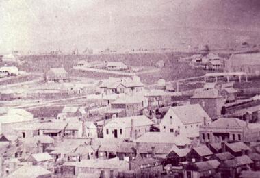
BLOWN UP PHOTO OF VIEW OVER LOOKING FRASER ST. FROM "THE ROCKS". NOTE 2 CHURCHES - ONE C OF E, LATER MOVED TO PRESENT SITE, NEXT TO BLUE STONE ST. PAUL'S. CLUB HOTEL ON LEFT. "METHODIST CHURCH WITHOUT SPIRE AND MARKET NEXT ON PRESENT POLICE STATION PADDOCK OPPOSITE THE METHODIST CHURCH (THEN WESLEYAN) IS THE OLD CEMETERY AND THERE ARE WHITE FORMS LIKE TOMBSTONES SHOWING.BLACK AND WHITE PHOTOGRAPH OF VERY EARLY CLUNES - BUILDINGS, CHURCHES, HOUSESPRIMITIVE METHODIST CHURCH IN HILL ST.local history, photography, photographs, clunes township -
 Eltham District Historical Society Inc
Photograph - Digital Photograph, Alan King, St Andrews Anglican Church, St Andrews, 30 January 2008
Built c.1868, St Andrew’s Anglican Church is Nillumbik Shire’s oldest timber church and is historically, socially, and spiritually significant to the Shire of Nillumbik. The church is historically significant because it may have given its name 'St Andrews' to the town (another suggestion is that the name came from the local hotel), it is also historically significant as one of only four buildings that remain from the Caledonian goldfields era of Queenstown (now St Andrews) and one of only a handful of buildings that survived the 1960s bushfires. The church is historically, socially, and spiritually significant because it has played an important part in community life for more than 150 years; a proposal to move the church in 1984 met with strenuous opposition. Much of the fires on Black Saturday 2009 were the north of the town. The town itself remained intact - as did this heritage building. Covered under Heritage Overlay, Nillumbik Planning Scheme. National Trust of Australia (Victoria) Local significance Published: Nillumbik Now and Then / Marguerite Marshall 2008; photographs Alan King with Marguerite Marshall.; p69 The St Andrews Anglican Church and former St Andrews Primary School, are two reminders of the district’s early days, when it was founded on gold. St Andrews, then called Queenstown, was the earliest goldfield in the Caledonia Diggings.1 It was the Upper Diamond Gold Mining and Administrative Centre, with 3000 miners. Queenstown was also the seat of the Court of Petty Sessions. The church and school then stood close to European and Chinese stores, three hotels, a brewery and a quartz mill.2 In 1861, Queenstown was officially proclaimed a township. From 1865, the name Queenstown was interchangeable with St Andrews, until 1952, when the town was officially named St Andrews. As gold declined from the early 1880s, Queenstown changed dramatically into a settlement of small farms. St Andrew’s Anglican Church, built in 1868, is the Shire’s oldest timber church and possibly gave its name to the township.3 The small timber church was opened on November 1, 1869, by the Dean of Melbourne. Anniversary tea meetings helped raise funds, and in 1889, a three-bedroom parsonage was built alongside. In 1910, the vicar, the Rev Selwyn Chase (and friend of the Scouting Movement’s founder, Baden Powell), established the 1st Queenstown Scout Troop, only two years after Scouting began in Australia. The church was important to the lives of many local residents who were baptised, married and had funeral services there. But by the 1950s the population had decreased and so did the weekly attendances. Around the mid-1960s the church closed, then fell into disrepair. So in the mid 1980s it was sold to the Education Department and was under threat of relocation or demolition. However this caused such opposition from locals,4 that instead, the Anglican church leased it as part of the Panton Hill parish5 and it was reconsecrated in 1987. Queenstown’s first school was held in a tent after transferring from Andersons Creek, Warrandyte.6 From 1858 a church school, Caledonia Diggings, stood west of the main road, a quarter of a mile (0.4km) before Buttermans Track. In 1882 the school was moved from a leased building, owned by headmaster Robert Harris, into a larger building on the corner of the School and the Heidelberg-Kinglake Roads. It had been moved from Smiths Gully and included a teacher’s three-roomed residence.7 In 1887 the school was replaced by the Queenstown State School No 128, although it was also called Caledonia Diggings until 1891. In 1956 it was renamed St Andrews. Still standing, this building is now used as the St Andrews Community Centre and the residence is leased for private use. The original timber-lined room remains alongside the extensions, and is distinctive with its high ceiling and tall small-paned windows. In 1984 a new school was built 500 metres west of the old school. Many residents have contributed much to St Andrews but one family that has done so for several generations is the Harris family. Robert Harris was an active member of the St Andrew’s Anglican Church, and worked hard at improving the town’s amenities until his death in 1887. He was a signatory to the successful 1863 petition to the Chief Commissioner of Police, against the proposed removal of the Court of Petty Sessions and police station at the Caledonia Diggings. The police station stayed in the town until 1917. Harris was Head Teacher of Queenstown State School from 1864 to 1874, then of the Smiths Gully school until it closed in 1882, and he continued teaching at Panton Hill until his death. His son, Robert Charles Harris, was editor and printer of the local newspaper, The Evelyn Observer, from 1873 until 1915. Robert’s son, William Shelley Harris, served in the Boer War and in World War One. In 1928 he became Kinglake National Park’s first park ranger. Robert’s daughter Elizabeth, taught needlework at Queenstown State School, and later ran the post office in Kinglake.This collection of almost 130 photos about places and people within the Shire of Nillumbik, an urban and rural municipality in Melbourne's north, contributes to an understanding of the history of the Shire. Published in 2008 immediately prior to the Black Saturday bushfires of February 7, 2009, it documents sites that were impacted, and in some cases destroyed by the fires. It includes photographs taken especially for the publication, creating a unique time capsule representing the Shire in the early 21st century. It remains the most recent comprehenesive publication devoted to the Shire's history connecting local residents to the past. nillumbik now and then (marshall-king) collection, st andrews, st andrews anglican church -
 Eltham District Historical Society Inc
Photograph - Digital Photograph, Alan King, St Andrews Hotel, 2 February 2008
The c1860 St Andrews Hotel, with the c1930 additions, and the Canary Island Palm, and the surrounding site to the title boundaries are historically, socially and aesthetically significant to the Shire of Nillumbik. The St Andrews Hotel is historically significant because it may have given its name 'St Andrews' to the town (another suggestion is that the name came from St Andrews church) and for its connection to Ewen Hugh Cameron (1831-1915) the prosperous local farmer, member of the Eltham Roads Board/Shire Council and local MP. It is also significant as the oldest hotel building in the former Shire of Eltham, as one of the few surviving buildings connected with the Caledonian goldfields era and as one of a handful of early structures to have survived the 1960s bushfires; the additions and alterations to the hotel reflect its long life. The hotel is socially significant because it has served as an important meeting place for more than 160 years. The Canary Island Palm is historically significant as a rare example of exotic tree planting in this rural area. The tree is aesthetically and historically significant as a local landmark and for its contribution to the streetscape and landscape value. Covered under Heritage Overlay, Nillumbik Planning Scheme. Published: Nillumbik Now and Then / Marguerite Marshall 2008; photographs Alan King with Marguerite Marshall.; p71 Built around 1860, St Andrews Hotel has changed little since it first welcomed thirsty gold diggers from the Caledonia Goldfields. The timber building, with gabled roof, beamed ceilings and a massive fireplace, is Nillumbik Shire’s oldest hotel and has always been an important community centre, particularly in its early days. Fortunately, the hotel and the near-by Canary Island Palm Tree, which is quite rare in this area, survived the 1960s bushfires, along with a few other early buildings. St Andrews (formerly Queenstown) was founded on gold, as were Panton Hill (formerly Kingstown), Research and Diamond Creek, from the mid-1850s to the 1860s. But by the early 20th century common use changed the name Queenstown to St Andrews, possibly after this hotel or after the church or the mining district.1 The Caledonia Diggings were probably named by Scottish settlers after the Roman name for Scotland, despite this land bearing little similarity to their homeland.2 Queenstown, which was proclaimed as a township in 1861, was the gold-mining centre on the Upper Diamond and in the 1850s had up to 600 European inhabitants and a small camp of Chinese on the flats along the creek. Queenstown was the administrative centre of the Upper Diamond with three hotels, a brewery and a slaughterhouse.3 It is unclear which hotel was the district’s first, as distinct from the earliest unlicensed grog shops, some of which operated in tents. John Corke Knell was one of eight unlicensed storekeepers supplying drink to miners at Caledonia in 1857, named by Sgt. McNamara of the Caledonia Police Station.4 In February 1859, Knell apparently bought most of the present hotel’s site at the first township land sales. As he was a local storekeeper, he might have first established a store there.5 Knell and his wife Eliza were early licensees of the St Andrews Hotel. The hotel had eight bedrooms – including three for public use – and the dining-room seated 30 people. It is thought they named the hotel St Andrews after Eliza’s hometown of St Andrews in Scotland. St Andrews Hotel was an important local centre in several ways. In the same building the Knells also operated a post office and general store. In 1867 Mrs Knell was appointed Deputy Registrar of Births and Deaths for Queenstown. The hotel was also used to hold inquests into people’s deaths when the police residence became too small.6 The hotel also became a fashionable destination at Christmas for parties from Melbourne. In 1868, possibly following her husband’s death, Mrs Knell applied for a temporary licence, which was then transferred to Robert Smith after their marriage in 1869. But then, possibly after Robert’s death, Mrs Smith operated the hotel until 1892. This contradicts a report in The Evelyn Observer 1882 that JC Knells of the St Andrews Hotel was granted a publican’s licence in the Queenstown Police Court. At that time he was supposed to have been dead for around 14 years! Although Mrs Smith was a respected citizen, known for her geniality and as an ideal hostess, she had a minor brush with the law when she was fined ten shillings for not lighting a lamp outside her licensed premises.7 From 1892 several publicans owned the hotel including W Atkins, from 1895. In 1909 the licensee was apparently Mrs Smith’s son, Walter Knell, who held the licence until at least the 1920s. Not surprisingly, this old hotel has attracted romantic stories. Mrs Smith is said to be seen roaming the pub in her nightdress – even though she was buried in the Queenstown Cemetery in 1911.8 A musical The Hero of Queenstown, set in the hotel, was written and produced by local actor Reg Evans in the 1970s.This collection of almost 130 photos about places and people within the Shire of Nillumbik, an urban and rural municipality in Melbourne's north, contributes to an understanding of the history of the Shire. Published in 2008 immediately prior to the Black Saturday bushfires of February 7, 2009, it documents sites that were impacted, and in some cases destroyed by the fires. It includes photographs taken especially for the publication, creating a unique time capsule representing the Shire in the early 21st century. It remains the most recent comprehenesive publication devoted to the Shire's history connecting local residents to the past. nillumbik now and then (marshall-king) collection, st andrews hotel -
 Eltham District Historical Society Inc
Photograph - Digital Photograph, Alan King, St Matthew's Church and Hall, Panton Hill, 27 March 2008
St. Matthew's Church has historic significance as the town's church and physical and social focus for the community. The standard design buildings are good examples and important streetscape elements. The war memorial cross is the area's monument to the 20th century wars and its modest scale in comparison with the granite Eltham and towered Kangaroo Ground memorials illustrates the lack of affluence in the town and surrounding area. The grouping of church, school, store and post office is typical of country villages throughout Victoria. The Radiata Pine plantings are significant as an intact line of shelterbelt planting typical of the early 20th century. (Bick Study 1992) Covered under Heritage Overlay, Nillumbik Planning Scheme. Published: Nillumbik Now and Then / Marguerite Marshall 2008; photographs Alan King with Marguerite Marshall.; p63 Panton Hill’s first church services were held in a simple building made of paling timber, opposite the Hotel de France. The building was also used for Sunday School, a school and a hall.1 The St Matthew’s Church and hall at the corner of Church Road and Kangaroo Ground-St Andrews Road, were built in the early 20th century in the standard rectangular style of the times. The intact belt of Radiata Pines was common at that time. The war memorial concrete cross is the area’s monument for the 20th century wars. It is much more modest than those in Eltham, and particularly in Kangaroo Ground, demonstrating those townships’ comparative affluence.2 Early settler J Hughes, who donated the land to the Church of England, was the first to be married at St Matthews when he married Rachel Coutie. In later life he became a minister of religion.3 One much-liked preacher was George Hollow, who with his sister playing the harmonium, conducted church services at Panton Hill, St Andrews and Christmas Hills, for many years.This collection of almost 130 photos about places and people within the Shire of Nillumbik, an urban and rural municipality in Melbourne's north, contributes to an understanding of the history of the Shire. Published in 2008 immediately prior to the Black Saturday bushfires of February 7, 2009, it documents sites that were impacted, and in some cases destroyed by the fires. It includes photographs taken especially for the publication, creating a unique time capsule representing the Shire in the early 21st century. It remains the most recent comprehenesive publication devoted to the Shire's history connecting local residents to the past. nillumbik now and then (marshall-king) collection, panton hill, st matthew's church, panton hill war memorial -
 Clunes Museum
Newspaper - NEWSPAPER CUTTING, 1 Overlanders Settle at Clunes .2 Clunes - Where the Old and the New Mingle, 18/10/1990
... Club Hotel Pastoralists CLUNES TOWNSHIP AND MINING Nil .1 ....1 Page from "The News" Thursday Oct 18 1990 containing several articles on Clunes .2 Page from "The News" Thursday Oct 18 1990 containing several articles on ClunesNilclub hotel, pastoralists, clunes township and mining -
 Lakes Entrance Historical Society
Photograph, 1950c
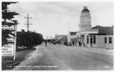
... Lakes 1950 (on back) Hotels Transport Township Black ...Lakes 1950 (on back)Black and white copy small format photograph showing view of Central Hotel, incorporating both the Esplanade and Mechanic St. Cars of the era parked and driving by. Lakes Entrance Victoriahotels, transport, township -
 Lakes Entrance Historical Society
Photograph, 1950c
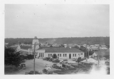
... Hotels Memorials Township Black and white photograph ...Black and white photograph showing both sides of the Esplanade. Clear view of the Central Hotel, with tower, parked cars of the era, several memorial cypress trees growing in lawn. Lakes Entrance Victoriahotels, memorials, township -
Merbein District Historical Society
Document, Back to Merbein Civic Dinner Toast List & Menu (2 copies), 18 Aug.1959
commercial hotel, merbein golden jubilee, celebrations, mildura shire council, j.k. hudson, c.h. martin, angus cameron, merbein township, back to merbein -
Merbein District Historical Society
Document, Back to Merbein Golden Jubilee Civic Dinner Invitation, 18 Aug.1959
mrs a.h. cameron, shire of mildura, commercial hotel, merbein golden jubilee, celebrations, mildura shire council, merbein township, back to merbein, angus h. cameron -
Merbein District Historical Society
Document, Alice Skjellerup - Merbein School Teacher, c.1928
teachers, merbein state school, dorothy russell, miss driscoll, jim herbert, merbein hotel, mr mccannon, merbein west state school, merbein township, schools, alice skjellerup -
 Clunes Museum
Photograph, 1869
UNION BANK - LATER A.N.Z. NOW PRIVATE RESIDENCE. CORNER OF TEMPLETON ST. NEXT TO C. OF E. - NOW SUNDAY SCHOOL. NEXT TO PRESENT C. OF E. NOTE BELL ON BUILDING NEXT TO RED BOOT WAS A SCHOOL.- TWO CHURCHES ON TOP OF NORTH CLUNES HILL. ONE OF THESE BECAME THE ASSEMBLY HALL AT TOWN HALL. SIGNS ON BUILDINGS, KENT EDWARD DART HOTEL, PITCHER BROS, PORT PHILLIP BAKERY R. HARVEY, C. WILES WASHINGTON HOTEL, R. MORRISON AGE OFFICE NEWS, BULL & MOUTH COACH OFFICE J. H. DALTON.1 PHOTOGRAPH OF A PORTION OF A LITHOGRAPH OF LOWER FRASER STREET, CLUNES. WOODEN BUILDINGS IN FOREGROUND, CRESWICK CREEK BEHIND BUILDINGS. HILL IN BACK GROUND. .2 .3 BLACK AND WHITE COPIES OF THE ABOVE PHOTOGRAPH PRINTED ON GLOSS PAPERshops, red boot palace, clunes township -
 Lakes Entrance Historical Society
Postcard - National Bank, The Rose Series, 1955c
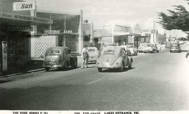
Black and white postcard of portion of Esplanade, showing petrol bowser, Newsagency, National Bank, a cafe advertising Sennitts Ice Cream, Central Hotel in distance. Also cars on roadway. Lakes Entrance VictoriaThe Esplanade, Lakes Entrance, Victownship, retail trade -
 Linton and District Historical Society Inc
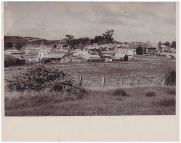
Photograph, Linton Township from Slaughterhouse Hill, circa 1920s, 1920
Slaughterhouse Hill was so named because Bennett's butchers had a slaughterhouse there.A view of Linton taken from Slaughterhouse Hill to the north-east of the town. Numerous buildings are identifiable in the photograph. In the middle foreground are the railway station, platform and station-master's house. The Grenville Standard building is visible in Clyde Street, and the Post Office and Bank of NSW buildings can be seen near the corner of Clyde and Sussex Streets. In the distance (along Sussex Street) the Royal Standard Hotel and the Shire Offices (original building) can be seen. St Paul's Church of England is on the far left of the photograph."Esther Cluff, Linton".linton township, slaughterhouse hill -
 Linton and District Historical Society Inc
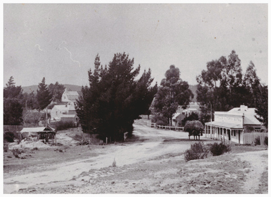
Photograph, Murrell's Victoria Hotel and Edinburgh Mine, Skipton Road, Linton
... Linton township Murrell's Victoria Hotel Edinburgh Mine ...Two copies - original sepia photograph, and restored black and white copy, showing road coming in to Linton from Skipton, Murrell's Hotel on RHS, Edinburgh Mine works on LHS. Also mounted photograph.On back of original photograph: "Esther Cluff".linton township, murrell's victoria hotel, edinburgh mine -
 Lakes Entrance Historical Society
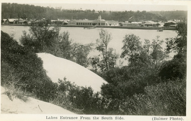
Postcard - the Central Hotel, butcher shop, bluestone wall at lake edge, and two small jetties. Sand hills and natural vegetation in foreground. Lakes Entrance Victoria, 1930c
... Other black and white copy 17 x 25 01417.1 Township ...Other black and white copy 17 x 25 01417.1Black and white postcard of the town, taken from the southern shore of the lake, showing residences, the Central Hotel, butcher shop, bluestone wall at lake edge, and two small jetties. Sand hills and natural vegetation in foreground. Lakes Entrance VictoriaLakes Entrance from the South Sidetownship, waterfront, retail trade, hotels, shops -
 Sunbury Family History and Heritage Society Inc.
Postcard, Newcolourvue Productions Pty.Ltd, Sunbury Victoria, c1970s
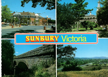
The four photographs on the post card are well-known places in the town. They are the 1930s Royal Hotel building which was build on the same site of the original building on the corner of Evans and Brook Streets, Rupertswood Mansion, built 1874-45, the historic bluestone road bridge over Jacksons Creek and a view of the township in the 1970s taken from Francis Boulevard.The four views of Sunbury give an overview of the township in the 1970s before the increased development took place from the 1980s onwards.A coloured collection of four non-digital photographs of places in Sunbury in post card format. The edges of the post card are rippled. the back of the card gives details of the places as well as the maker.Sunbury Victoriaroyal hotel, rupertswood mansion, bluestone road bridge, sunbury, post cards -
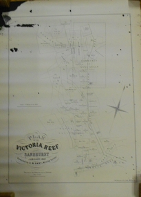 Bendigo Historical Society Inc.
Document - MARKS COLLECTION: MAP OF VICTORIA REEF MINING CLAIMS
Copy of map. On bottom LH side: Plan of the Victoria Reef Sandhurst January 1867, Compiled by G.W. Hart, Mining Surveyor. Published by John N. Macartney, Argus Agent, Sandhurst. Price 4/- each. On bottom Rh side J.W. Pearson & Co. Lith. Melbourne Plan shows mining claims and names of holders, scale (4 chains to one inch) Loddon Road, Mount Korong Road, Ironbark Gully, township of Long Gully, Quartz Miners' Arms and Gold Mines Hotel on Loddon Road.bendigo, mining, victoria reef plan -
 Linton and District Historical Society Inc
Photograph, View of Linton, from corner of York and Grant Streets
Black and white photograph of houses in Surrey St closest to camera. Shire offices, Verdoorn's building, Railway Hotel, post office roof can be seen in distance. Date unknown.linton township -
 Stawell Historical Society Inc
Photograph, Glenorchy 1866
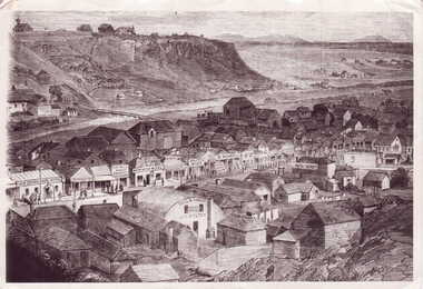
Glenorchy. Part of a collection of Photographs by Mr. O.G. Armstrong as commissioned by the Shire of Stawell for the Inter-colonial and Paris Exhibition in Melbourne in 1866. Glenorchy township began as a resting place for bullock teams and travellers in the 1840s. In 1847, John Gleeson built the Four Posts Inn, which then became the name of the settlement. Gleeson is credited with naming the settlement Glenorchy, meaning tumbling waters, after his birth place in Scotland. In 1865 the Township consisted of a church, school, three hotels the Four Post Inn built 1847, Royal Hotel built 1855, The Royal Mail Hotel built1862. As well as boot makers, a blacksmith, stores, butcher and other enterprises. The town was a postal centre served by three coaches each day until the advent of the railway. stawell -
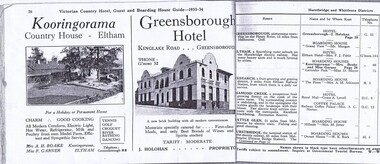 Greensborough Historical Society
Magazine - Advertisement, Greensborough Hotel Advertisement 1933-34, 1933-1934
An advertisement for Greensborough Hotel in the town of "Greensborough, picturesque township on the Plenty River, 13 miles from Melbourne."Photograph show the "new brick building with all modern conveniences'. Greensborough in the 1930s was a popular spot for picnics and holidays.2 pages from a Victorian Railways travel journal. Advertisement for Greensborough Hotel 1933-34. Photocopy from original journal.greensborough hotel, greensborough -
Lakes Entrance Historical Society
Album, M Fish, East Gippsland Settlement
Many copied from publications of Bairnsdale, Metung, Lakes Entrance, Lake Tyers, including Whiter Family and Whiters Camp Park, Gill Roberts family and "Firefly" S.S. Dargo, P.S. Tanjil, Captain James Bull, Scone Cottage, Bancroft Bay, W H Glover Scarborough Hotel, J.C. Dahlsen, Kitty Johnson, Nelly Blair, Red folder containing 85 images of East Gippsland settlements and activities East Gippsland Victoriawaterways, township, ships and shipping, genealogy -
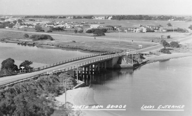 Lakes Entrance Historical Society
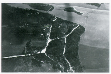
Photograph - North Arm bridge Lakes Entrance Victoria, Bulmer H D, 1945c
Notes: Club Hotel spit has not yet been formed. Also Postcard 8.5 x 13.5Black and white photograph of the North Arm Bridge, It shows the reinforced concrete bridge over the North Arm, and a rear view of other notable buildings. In the background sand hummocks. Lakes Entrance Victoriabridges, topography, township