Showing 18087 items matching "view-master"
-
 Federation University Historical Collection
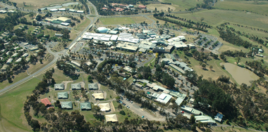
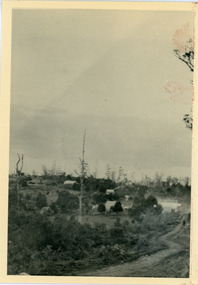
Photograph, Aerial View of Gippsland Campus South View
Colour photograph of an aerial view of Gippsland Campus (South View)churchill campus, gippsland campus, binishell, student residences -
 Federation University Historical Collection
Document - Document - Letter, Ballarat Junior Technical School: Letter from Mr Robert Watson, Head Master re Return to duty of staff member, 1961
Letter from Robert Watson, Head Master, reporting the return to duty of Mr Branko Bogicevic after being absent due to injury. This was during a physical training period. 1 white page, typedballarat junior technical school, head master, robert watson, return to duty, branko bogicevic, injury -
Federation University Historical Collection
Document - Document - Letter, Ballarat Junior Technical School: Letter from Robert Watson, Head Master, re Group certificate for Mrs E Waight.1961
Letter from Robert Watson, Head Master, requesting a group certificate showing tax deductions made for teacher Mrs E Waight, IV Primary, who resigned. 1 white page, typedballarat junior technical school, robert watson, head master, group certificate, e waight, retired -
 Victorian Interpretive Projects Inc.
Photograph - Colour, Clare Gervasoni, View from Nevin's Road towards the Swiss Italian Enclave at Yandoit Creek, 2014, 12/2013
For a 2004 comparative view see http://victoriancollections.net.au/items/52fdd83d2162ef1820380448 Two colour photographs showing the view from Nevin's Road towards the Swiss Italian Enclave at Yandoit Creek, 2014yandoit, yandoit creek, yandoit hill, gervasoni, drystone, swiis/italian -
University of Melbourne, Burnley Campus Archives
Administrative record - Report, The University of Melbourne, Faculty of Land and Food Resources, The Burnley Master Plan, 2007
finance, buildings -
 Kew Historical Society Inc
Photograph, J F C Farquhar, A View in Studley Park Road, 1891
At the beginning of the 1890s, the Kew businessman and Town Councillor, Henry Kellett, commissioned J.F.C. Farquhar to photograph scenes of Kew. These scenes included panoramas as well as pastoral scenes. The resulting set of twelve photographs was assembled in an album, Kew Where We Live, from which customers could select images for purchase.The preamble to the album describes that the photographs used the ‘argentic bromide’ process, now more commonly known as the gelatine silver process. This form of dry plate photography allowed for the negatives to be kept for weeks before processing, hence its value in landscape photography. The resulting images were considered to be finely grained and everlasting. Evidence of the success of Henry Kellett’s venture can be seen today, in that some of the photographs are held in national collections.It is believed that the Kew Historical Society’s copy of the Kellett album is unique and that the photographs in the book were the first copies taken from the original plates. It is the first and most important series of images produced about Kew. The individual images have proved essential in identifying buildings and places of heritage value in the district.This is the earliest known photograph of the exterior of Byram (later Tara Hall). It shows the original red brick fence, its asymmetrical gate and gateposts, with a large terra cotta gargoyle surmounting the higher of the two. The architect, Edward Kilburn designed Byram in the Arts & Crafts style for the industrialist George Ramsden. Construction began in 1888 and was reputed to have lasted three years. The mansion had frontages to Studley Park Road and Stevenson Street, including gardens laid out with great taste, including pleasure grounds, tennis lawn, fruit and flower garden, and paddock. The size of many of the trees in the garden indicate that many survived from the garden of Clifton Villa, the previous single-storeyed house built on the site by the Stevenson brothers. Byram had views to Melbourne and Port Phillip Bay. The house was demolished in 1960, despite opposition from the National Trust (Victoria), and its gardens subdivided into residential allotments.A View in Studley Park Roadkew illustrated, kew where we live, photographic books, henry kellett, byram, tara hall, goathlands -
Federation University Historical Collection
Document - Document - Letter, Ballarat Junior Technical School: Letter from Mr Garner, Head Master, to Mr John, Ballarat
Letter from Mr L Garner, Head Master, to Mr John of M B John Ltd, Ballarat. Letter conveys thanks for allowing fourth form boys to visit the foundry works. visit was interesting and informative.. Yellow paper typedballarat junior technical school, l garnar, junior technical certificate, head master, mr john, m b john ltd, foundry, fourth form visit -
 Kew Historical Society Inc
Photograph, J F C Farquhar, Bird's Eye View Looking West, 1891
At the beginning of the 1890s, the Kew businessman and Town Councillor, Henry Kellett, commissioned J.F.C. Farquhar to photograph scenes of Kew. These scenes included panoramas as well as pastoral scenes. The resulting set of twelve photographs was assembled in an album, Kew Where We Live, from which customers could select images for purchase.The preamble to the album describes that the photographs used the ‘argentic bromide’ process, now more commonly known as the gelatine silver process. This form of dry plate photography allowed for the negatives to be kept for weeks before processing, hence its value in landscape photography. The resulting images were considered to be finely grained and everlasting. Evidence of the success of Henry Kellett’s venture can be seen today, in that some of the photographs are held in national collections.It is believed that the Kew Historical Society’s copy of the Kellett album is unique and that the photographs in the book were the first copies taken from the original plates. It is the first and most important series of images produced about Kew. The individual images have proved essential in identifying buildings and places of heritage value in the district.Before true aerial photography became possible, photographers such as J.F.C. Farquhar were compelled to shoot their images from the highest vantage point. Here, it is presumed to be the roof of Xavier College, from which the panoramic view extends west towards the rise of Studley Park. The houses in the foreground face the southern end of Gellibrand Street. Wellington Street is at an angle to the camera with the Queen Street intersection on the near right. The wooden building behind the large horse paddock on the other side of Gellibrand Street is the Kew Recreation Hall, built 1888, demolished 1960. It was reputed to have one of the finest dancing floors in or around Melbourne. The Bowling Green at the rear of the Hall belonged to the Kew Bowling Club. Further west is the Kew Railway Station on Denmark Street, opened to the public in 1887. At this period, much of Studley Park was locked up in large landholdings, dominated by large mansions such as ‘Byram’. Bird's Eye View Looking Westkew illustrated, kew where we live, photographic books, henry kellett, denmark street, kew recreation hall, kew bowling club, wellington street -
 Marysville & District Historical Society
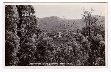
Postcard (item) - Black and white postcard, Valentine Publishing Co. Pty. Ltd, View From Jock's Lookout, Marysville. V. 21, 1923-1963
An early black and white photograph of the view from Jock's Lookout of Marysville in Victoria. An early black and white photograph of the view from Jock's Lookout of Marysville in Victoria. Jock's Lookout is situated on the Marysville-Wood's Point Road. The Marysville-Woods Point Road was originally part of the Yarra Track, constructed in the early 1860s to provide access between Healesville and the Woods Point Goldfields. Despite the steep terrain and engineering difficulties, the Yarra Track soon became a busy route used by pack horses, horse-drawn drays, and wagons. Today this sealed mountain road is a popular scenic drive between Marysville and Warburton. This postcard was published by the Valentine Publishing Co. Pty. Ltd. as a souvenir of Marysville.VALENTINE'S/ POST CARD/ A GENUINE PHOTOGRAPHjock's lookout, marysville, victoria, postcard, valentine publishing co, souvenir, marysville-wood's point road, yarra track, mining, warburton -
 Marysville & District Historical Society
Postcard (item) - Black and white postcard, Valentine Publishing Co. Pty. Ltd, View From Jock's Lookout, Marysville. V. 21, 1923-1963
An early black and white photograph of the view from Jock's Lookout of Marysville in Victoria.An early black and white photograph of the view from Jock's Lookout of Marysville in Victoria. Jock's Lookout is situated on the Marysville-Wood's Point Road. The Marysville-Woods Point Road was originally part of the Yarra Track, constructed in the early 1860s to provide access between Healesville and the Woods Point Goldfields. Despite the steep terrain and engineering difficulties, the Yarra Track soon became a busy route used by pack horses, horse-drawn drays, and wagons. Today this sealed mountain road is a popular scenic drive between Marysville and Warburton. This postcard was published by the Valentine Publishing Co. Pty. Ltd. as a souvenir of Marysville.VALENTINE'S/ POST CARD/ A GENUINE PHOTOGRAPHjock's lookout, marysville, victoria, postcard, valentine publishing co, souvenir, marysville-wood's point road, yarra track, mining, warburton -
 Greensborough Historical Society
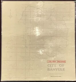
Map, Banyule City Council, MMBW, 1:2500 Series. City of Banyule. Master overlay, 1994_
This master overlay is the key to the Melbourne and Metropolitan Board of Works maps: MMBW, 1:2500 Series. The overlay was made by the City of Banyule using the Melways base plan (Edition 23, 1994-95). This overlay can be used to position maps in this series.Laminated map, with overlay of MMBW map grid.mmbw, melbourne and metropolitan board of works, banyule city council -
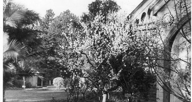 University of Melbourne, Burnley Campus Archives
Photograph - Black and white print, View Across Lawn to Summer House, 1942-1946
Possibly from J.L. Provan's photograph collection. Note by T.H. Kneen 8 April 1992, "View is from Botany room entry, east of main entry to Pavilion."Black and white photograph. View from corner of the Pavilion towards the Summer House. Tree in blossom in the foreground.j.l. provan, botany room, pavilion, garden view, summer house, shelter shed, blossom tree -
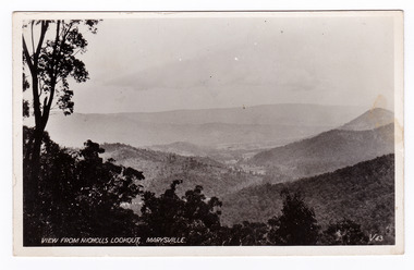 Marysville & District Historical Society
Postcard (item) - Black and white postcard, Valentine Publishing Co. Pty. Ltd, View From Nicholl's Lookout, Marysville. V. 43, 1923-1963
An early black and white photograph of the view of Marysville in Victoria taken from Nicholl's Lookout.An early black and white photograph of the view of Marysville in Victoria taken from Nicholl's Lookout. This lookout is situated on the Marysville-Wood's Point Road. The Marysville-Woods Point Road was originally part of the Yarra Track, constructed in the early 1860s to provide access between Healesville and the Woods Point Goldfields. Despite the steep terrain and engineering difficulties, the Yarra Track soon became a busy route used by pack horses, horse-drawn drays, and wagons. Today this sealed mountain road is a popular scenic drive between Marysville and Warburton. This postcard was published by the Valentine Publishing Co Pty. Ltd. as a souvenir of Marysville.VALENTINE'S/ POST CARD/ A GENUINE PHOTOGRAPHmarysville, nicholl's lookout, victoria, postcard, valentine publishing co, souvenir -
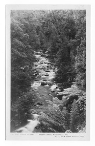
![View of Sailor’s Creek Bridge / [by] Nicholas Caire, circa 1876](/media/collectors/550653872162f11fb04854aa/items/577b5b7ed0cdd10948d14ae1/item-media/577b5be9d0cdd10948d196a2/item-fit-380x285.jpg) Kew Historical Society Inc
Kew Historical Society IncPhotograph, Anglo-Australasian Photographic Company, View of Sailor’s Creek Bridge, c.1876
Nicholas Caire was born on Guernsey in the Channel Islands in 1837. He arrived in Adelaide with his parents in about 1860. In 1867, following photographic journeys in Gippsland, he opened a studio in Adelaide. From 1870 to 1876 he lived and worked in Talbot in Central Victoria. In 1876 he purchased T. F. Chuck's studios in the Royal Arcade Melbourne. In 1885, following the introduction of dry plate photography, he began a series of landscape series, which were commercially successful. As a photographer, he travelled extensively through Victoria, photographing places few of his contemporaries had previously seen. He died in 1918. Reference: Jack Cato, 'Caire, Nicholas John (1837–1918)', Australian Dictionary of Biography.An original, rare photograph from the series 'Views of Victoria: General Series' by the photographer, Nicholas Caire (1837-1918). The series of 60 photographs that comprise the series was issued c. 1876 and reinforced a neo-Romantic view of the Australian landscape to which a growing nationalist movement would respond. Nicholas Caire was active as a photographer in Australia from 1858 until his death in 1918. His vision of the Australian bush and pioneer life had a counterpart in the works of Henry Lawson and other nationalist poets, authors and painters.Views of Victoria (General Series) No.31 / ‘View of Sailor’s Creek Bridge’ / Albumen silver photograph mounted on boardOn Reverse" ‘Sailor’s Creek as situated in the Jim Crow Ranges, which Range forms a portion of the Great Dividing Range of Mountains in Victoria. These hills contain many romantic spots. The one which forms the subject of the present illustration is a view of the Bridge which spans the Creek. Gold has been found throughout the course of the bed of this Creek in payable quantities. The diggers, as may be seen in the photograph, have constructed sluices in the side of the embankment for the purpose of washing the fine gold contained in the wash-dirt.’nicholas caire (1837-1918), sailor's creek (vic), gold mining (vic) -
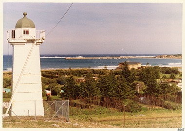 Flagstaff Hill Maritime Museum and Village
Photograph - Historical, Flagstaff Hill, John Lindsay, View of the Bay from the south boundary of the Ports and Harbours land, 1970s
The photograph shows the view of the shore and Lady Bay with the Breakwater and Middle Island all visible. It was taken to show that the Flagstaff Hill area was unlikely to have any further development between it and the Bay, with the view of development of the Flagstaff Hill Maritime Museum and Village. This photograph, a print, is one of a set of five that show the site of Flagstaff Hill. The photographer was John Lindsay, Founding Director of Flagstaff Hill Maritime Museum and Village, with the words "Photo J Lindsay" on the back. It was taken in the early 1970s during the initial stages of the development of Flagstaff Hill as a Museum and Maritime Village. The photographs belonged to the donor's grandparents, who lived in the Warrnambool district of Allansford/Naringal. The photograph is a record of the site and surrounds of Flagstaff Hill Maritime Museum and Village before its development and opening in 1975. It shows the Surfside Holiday Park, Surf Lifesaving Club, and the Breakwater. The photograph is significant for recording the location and condition of the Lower Lighthouse on the Hill.Coloured photograph, glassy print, one of a set of five. Flagstaff Hill's Lower Lighthouse is in the foreground above the Surfside Holiday Park. To the right of centre is the Surf Lifesaving Club. In the background is Lady Bay and the Breakwater and Middle Island, with the Southern Ocean the other side. The photograph's paper has the printer's watermark and a pencilled inscription on the back. The early 1970s scene was photographed by John Lindsay, Warrnambool.Label on the back: "VIEW OF THE BAY FROM the southern boundary of the Ports and Harbours land. No development below this area is likely to obstruct the view, due to the steep grade down to the Southern boundary of Flagstaff Hill property." Handwritten in pencil: "Photo J Lindsay"flagstaff hill, flagstaff hill maritime museum and village, warrnambool, maritime museum, maritime village, great ocean road, shipwreck coast, 1970s, photograph, surfside holiday park, lady bay, flagstaff hill site, john lindsay, lower lighthouse, lower light, surf lifesaving club, breakwater, middle island, ports and harbours -
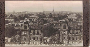 Linton and District Historical Society Inc
Stereograph, The Rose Stereographs, Melbourne, Sydney, Wellington and London, 16,300 Bird's-Eye View of Paris, France, Copyright 1912
One of two sets of stereographs donated by the O'Beirne family along with a stereoscope for viewing (Stereoscope is Registration no. 2014-51).Stereograph of two black and white images. Images show bridges over the River Seine. Eiffel Tower in background.16,300. BIRD'S-EYE VIEW OF PARIS, FRANCE, and Seven Bridges Over the Seine from Spire / of St. Gervais Church. Eiffel Tower in Distance.stereographs -
Federation University Historical Collection
Document - Document - Letter, Ballarat Junior Technical School: Letter from Mr Robert Watson, Head Master re Amendments to Staffing Schedule, 1961
Letter from Robert Watson, Head Master, listing the changes that have occurred to the Staffing Schedule. Since forwarding the original form in November the following has changed - student enrolments, two staff have been appointed to other schools - Mr J Nicholas and Mr Poynton 1 white page, typedballarat junior technical school, head master, robert watson, staffing schedule, prospective enrolments, j nicholas, st albans technical school, mr poynton, dereel primary school -
Ringwood and District Historical Society
Scrap Book, Scrap book of Mr. J.K. Turnbull, Ringwood's first Station Master, containing correspondence, newspaper clippings, obituaries and personal memorabilia c.1890-1913, c. 1890 - 1913
Mr J.K. Turnbulls own scrap book lent by his son to Mr McCaskill. Alan Carter got it from Mr McCaskill to return but the son died and Alan Carter gave it to the Historical Society. Mr Turnbull was Ringwood's first Station Master and a well liked person in the community.Mr J.K. Turnbulls own scrap book. Large blue cardboard covers with black and red embossing and 'Scraps' on front. Blue cloth spine. No pages held by spine - five with cuttings from papers pasted on to them; three handwritten letters; several single cuttings.; 1. Five pages of newspaper cuttings pasted to page.; 2. Post Office Telegraphs 14-Jan-1891; 3. Small ad. - Frank Lowe - is running a waggonette to meet every train - stables - 'Coach and Horses Hotel' 12-Jan-1913; 4. Mr Turnbull at Healesville; a favourite Returns; two cuttings with same story.; 5. Photocopy of the 'Programme of Dances for the Opening of the Ringwood Goods Shed' Monday 28 December 1887.; 6. Handwritten in pencil - New Goods Shed 28/11/1887. Opening ceremony 2-Dec-1887 - not very legible - 4 pages (15 x 10cm); 7. Two letters to Mr Turnbull from John Ross - 17-Jan-1891; 8. Letter from Samuel and Elizabeth Cutts and family to Mr Turnbull.; Note: Cutts, Elizabeth - owned the hotel at Burnt Bridge; Mr McCaskill was mayor and first President of the Historical Society; Carter, Alan - was father of Richard Carter. +Additional Keywords: Turnbull, J.K. / McCaskill, Mr / Carter, Alan / Lowe, Frank / Ross, John / Cutts, Samuel / Cutts, Elizabeth'Scraps' -
 Mt Dandenong & District Historical Society Inc.
Photograph, View From Range Road, Olinda. 1909, 1909
1909 view of Olinda showing 'Charlemont' guest house and the Olinda school on the skyline above Dodd's stables. Range Road (The Bullock Track) is in the foireground. The descriptive text on the reverse of this photograph was hand written by John Lundy-Clarke.1909 view of Olinda from Range Road (The Bullock Track). Showing school on skyline above Dodd’s stables with “Charlemont” on left.charlemont guest house, dodd, dodd's stables, stables, olinda, olinda school, range road, bullock track -
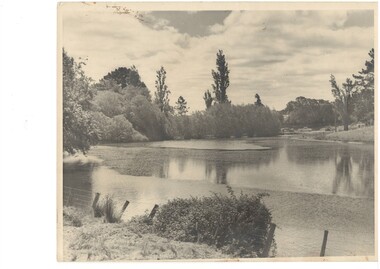 Buninyong & District Historical Society
Photograph - Original B/W Photograph, View over the Gong towards the Buninyong Gardens, with established trees and early model motor vehicles
The photograph, taken c 1940 show The Gong and the view to the Buninyong Gardens. The trees in the Gardens are well established and early model motor vehicles are seen parked on the Gong dam wall. The Gong and the Buninyong Botanic Gardens are iconic features of the town. They are of great historic, aesthetic and social significance. They are representative of early parklands.Original B/W photograph of the view over the Gong towards the Buninyong Gardens, with established trees and early model motor vehiclesthe gong, buninyong, gardens, botanic gardens, cars, parklands -
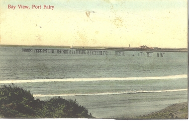 Port Fairy Historical Society Museum and Archives
Photograph - Postcard, Bay view
Hand coloured Photograph/postcard of East beach showing ruins of the pier and in the background the lighthouse keeper's residenceBay Viewbeach, sea, seascape, postcard, east beach, light house keepers house, pier -
Federation University Historical Collection
Document - Document - Letter, Ballarat Junior Technical School: Letter from Mr Garner to Head Master re Kevin Maxwell Onn, 1958
Letter from Mr Garner to the Head Master of school Kevin Maxwell Onn if transferring to before the end of the year. Lists subjects he has been studying while at Ballarat Junior Technical School for Form I JTS - English, Social Studies, Mathematics, Science, Solid Geometry, Modelling, Free Drawing, Woodwork, Sheetmetal Work and Music.1 cream coloured page, typedballarat junior technical school, head master, l garner, kevin maxwell onn, transferring, english, social studies, mathematics, science, solid geometry, modelling, free drawing, woodwork, sheetmetal, music -
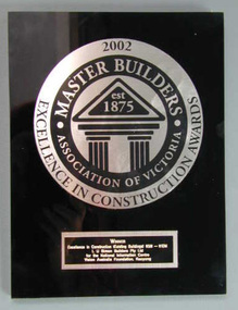 Vision Australia
Plaque - Image, Master Builders Excellence in Construction Awards, 2002
In 2002, the Master Building Excellence in Construction Award (Excellence in Construction (Existing Building) 85M-110M) was presented to L.U. Simon Builders Pty Ltd for the National Information Centre, Vision Australia Foundation, Kooyong. This award hung in the main corridor of the building, opposite the middle doorway from the drop off area, from 2002 until the building's refurbishment in 2017.Black and silver coloured plastic plaquevision australia foundation, awards -
 Marysville & District Historical Society
Postcard (item) - Black and white postcard, Rose Stereograph Company, Talbot Drive, Marysville, Vic. No. 4, View from Murray Pass, 1913-1967
An early black and white photograph of the view of the Taggerty River from Murray Pass near Marysville in Victoria.An early black and white photograph of the Taggerty River from Murray Pass near Marysville, Victoria. Murray Pass is located on the Lady Talbot Drive. Lady Talbot Drive a 24 kilometer scenic rainforest car journey which passes a number of walks and waterfalls in the Yarra Ranges National Park. Lady Talbot Drive is named after Lady Sarah Elizabeth, the wife of Sir Reginald Talbot, who was the Governor of Victoria from 25th April, 1904 to 6th July 1908. This postcard was produced by the Rose Stereograph Company as a souvenir of Marysville.POST CARD The "Rose" Series/ De Luxe A Real Photograph/ Produced in Australia Published by the Rose Stereograph Co./ Armadale, Victoria. Dear Harold/ This is the prettiest card I/ could get for you. Probably we will/ go this trip in a day or two./ Yours Nance xxx xxxmarysville, victoria, photograph, taggerty river, murray pass, lady talbot forest drive, 2309, postcard, souvenir, lady talbot drive, sir reginald talbot, sarah elizabeth talbot, rose series postcard -
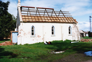 Charlton Golden Grains Museum Inc
Photograph, St Andrews Charlton Presbyterian Church demolition c.1989 side view, c.1989
The St Andrew Charlton Presbyterian Church was built in 1871 by James Patterson, a contractor and grazier of Nardoo Park, Woosang. Dismantled in 1989, The view is of the side of the church and the roofing has already been remove. The roof timber have been exposed. Bricks litter the ground.Colour Photo of St Andrews Presbyterian Church. Being demolished in c.1989. View is from the back.charlton presbyterian church, james patterson, church, presbyterian, pastoral care, manse, demolition -
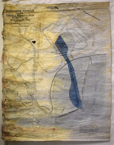 Warrnambool and District Historical Society Inc.
Map - Map of Proposed Alterations to Warrnambool Harbour 1925, Warrnambool Harbour Committee, Warrnambool Harbour Proposed Wharves and Basin in Lake Pertobe with Eastern Wall, 1925
This map was printed in 1925 and contains the Warrnambool Harbour alterations proposed by the Warrnambool Harbour Committee incorporating the original designs of Captain Menzies, the Warrnambool Harbour Master and the City Engineer, Mr A. Lavercombe. The main features of the proposal were the extension of the Eastern Wall to almost enclose the harbour and a basin in Lake Pertobe. The design was to be placed before the Victorian Royal Commission on the Outer Ports which was established partly to examine the allegations of unsatisfactory work carried out in Warrnambool when the Breakwater was extended 300 feet in 1914 and also to make recommendations regarding all regional ports. The Warrnambool Breakwater was completed in 1890 but failed to provide the shipping conditions needed to continue Warrnambool as a viable port. Many plans and proposals for port improvement such as this one were produced in the late 19th century and the first half of the 20th century with the port officially closed in the 1940s. Still today the Breakwater and Warrnambool Harbour conditions remain a source of contention.This map is significant as it shows a 1925 design for Warrnambool Harbour hitherto little-known. It also has markings showing land sites of the time (BayView Hotel, Woollen Mill etc.)This is a map made of thick yellow paper pasted onto a cloth backing. It has two cloth tags at the top for tying up the map when folded. It appears to be a hand-drawn map copied with printed material added. The map is shaded green and red in some areas. Attached by nails to the map are wooden frames, rounded at the bottom and partly curved at the top. The map is torn and partly detached at the top. The top frame has a cord attached for hanging the map.warrnambool harbour, captain menzies, a.lavercombe city engineer, warrnambool breakwater, royal commission on outer ports -
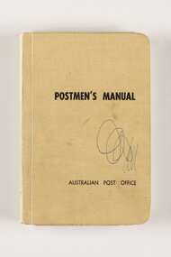 City of Greater Bendigo - Civic Collection
Manual, Post Master General's Department, Postmen's Manual, 1964
When the Commonwealth Post and Telegraph Act was passed in June 1902, and a national Postmaster General's Department (the PMG) was established the responsibility for the nation's mail and telephone services fell on Post Offices. The Bendigo Post Office, built in 1887 and situated on Pall Mall was the central distribution centre for receiving and delivering telegrams and continued to deliver communication and postal services until 1997. Now a Visitor Centre, dedicated volunteers at the Post Office continued to demonstrate and educate the public about the daily workings of the Post Office up until 2019 when Covid 19 disrupted every day life and Ted Rankins, the last Post Master and a long term telegraph volunteer at the Post Office, died. Manuals were issued to postmen to guide them in the delivery of letters and parcels and were small enough to be carried with them. This manual was used by the Bendigo Post Office postmen and is part of the postal collection donated by the Rankins family in memory of Ted Rankins,. Small, creamed coloured cloth covered manual. Contains forty four printed pages and two blank end pages covering all aspects of how to correctly deliver the post. Topics include 'Behaviour', 'Deceased Persons' and 'Bicycles' amongst many others. Book is bound and contains many extra additional paragraphs stuck in on appropriate pages noting changes and amendments. Additional amendments in handwritten red pen also occur on pages 28, 29 and 36.Front cover; Postmen's Manual / Australian Post Office Various annotations and updates throughout. ted rankins collection, bendigo post office, bendigo tourism, city of greater bendigo tourism, post office collection -
Federation University Historical Collection
Document - Document - Letter, Ballarat Junior Technical School: Letter from Mr Garner, Head Master, to Wing Commander Sleight, Commanding Officer, R A A F Station, Ballarat
Letter from Mr L Garner, Head Master, to Wing Commander Sleight, Commanding Officer of the R A A F Station, Ballarat, thanking him for allowing the visit of fourth form boys to the station. the staff and students informed me the visit arrangements were excellent. Second letter was confirming a conversation where the Wing Commander agreed to be the guest speaker at the speech night in December. . Yellow paper typedballarat junior technical school, l garnar, junior technical certificate, head master, wing commander sleight, commanding officer, r a a f station, fourth form visit, guest speaker, speech night -
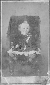 Stawell Historical Society Inc
Photograph, Master Alfred Thomas Huttley -- Studio Portrait
B/W: toddler on a chair wearing dress, dark white lace buckled. colour tinted, fair curly hair holding a coured Rosealfred Thomas Huttley ( my Father) Stewart & Co 217 Bourke St. E Near Parliment House Melbourne A Large Framed copy Of This Portrit may be had Price is View taken within 20 Miles of Town. -
Federation University Historical Collection
Document - Document - Letter, Ballarat Junior Technical School: Letter from Mr Robert Watson, Head Master re Staff Vacation Addresses, 1961
Letter from Robert Watson, Head Master, providing the vacation addresses of the staff at Ballarat Junior Technical School. Staff were R Watson, F Hewitt, B Johnson, B Longman, R Whitla, W Walker, K Hamilton, G Reeve, N King, R Dunlop, I Chisholm, A Leviston, G Poyton, J Benn, B Bogicevic, J Nicholas. 1 white page, typedballarat junior technical school, head master, robert watson, branko bogicevic, f hewitt, b johnson, b longman, r whitla, w walker, k hamilton, g reeve, n king, r dunlop, i chisholm, a leviston, g poyton, j benn, j nicholas