Showing 1234 items matching "crown land"
-
 Bendigo Historical Society Inc.
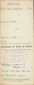
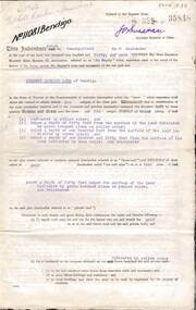
Document - H.A. & S.R. WILKINSON COLLECTION: CONTRACT OF SALE
This business was owned by father and son, Henry Archibald Wilkinson and Samuel Ronald "Ron" Wilkinson. Henry (1882-1954) was born in Shepparton and died in Bendigo. He was married to Grace Hovendon in 1908. Samuel Ronald "Ron" (1914-1995), Henry's son, was married to Florence Jean McKerlie in 1937.Contract of sale of land dated 26th September, 1955 between Mrs. I. Forster (seller) and Mrs. E.V. Raff (buyer) for land being lot 2 on plan of subdivision No.3905 lodged at the office of titles being part of Crown allotment 8 section 8 portion B described in certificate of title volume 4045 folio 961 situate No. 142 Myrtle Street, Bendigo. Together with right of carriage way over land at rear of property with weatherboard dwelling and all sundry, also all floor coverings, blinds, curtains, electric light fittings and shades and 'Pope' washing machine. Price 3,200 pounds.organization, business, h.a. & s.r wilkinson real estate -
 Bendigo Historical Society Inc.
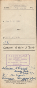
Document - H.A. & S.R. WILKINSON COLLECTION: CONTRACT OF SALE
... of Crown allotment 240 section E, land described in certificate.... Rae for land being part of Crown allotment 240 section E, land ...This business was owned by father and son, Henry Archibald Wilkinson and Samuel Ronald "Ron" Wilkinson. Henry (1882-1954) was born in Shepparton and died in Bendigo. He was married to Grace Hovendon in 1908. Samuel Ronald "Ron" (1914-1995), Henry's son, was married to Florence Jean McKerlie in 1937.Contract of sale of land dated 7th April, 1955 between Miss G.M. Lee (seller) and Mr. R.A. Rae for land being part of Crown allotment 240 section E, land described in certificate of title volume 2708 folio 415 and situate 83 Arnold Street corner Uley Street, Bendigo. Together with weatherboard dwelling and all sundry, including all furniture, curtains and blinds. Price 850 pounds.organization, business, h.a. & s.r wilkinson real estate -
 Eltham District Historical Society Inc
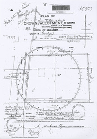
Document - Photocopy, Survey Field Notes of Part of Crown Portion 13, Section 4 at Eltham, Part of Lot 19 Subdivision of 13 Section IV (Holloways), Parish of Nillumbik, County of Evelyn, 5 May 1906
Portion of land bounded by: Main Road, Henry Street Application 35953 A. Mackensie Tyers, Licensed Surveyor, 5 May 1906map, neil webster collection, survey plan, surveyor field notes, 1906, application 33777, application 35953, henry street, main road eltham, maria street, rechabite hall* -
 Eltham District Historical Society Inc
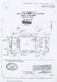
Document - Photocopy, Survey Field Notes of Part of Crown Portion 12, Section 4 at Eltham, Parish of Nillumbik, County of Evelyn, 4 July 1924
Portion of land bounded by: Main Road, Pitt Street, Bible Street, Franklin Street Application 46030 R.H. Woodcock, Licensed Surveyor, 4 July 1924map, neil webster collection, survey plan, surveyor field notes, 1924, application 46030, bible street, corn store, ernie andrew, franklin street, l. grant, main road eltham, maria street, peel street, pitt street -
 Eltham District Historical Society Inc
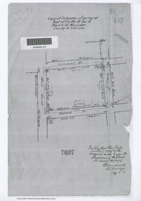
Document - Photocopy, Survey Field Notes of Part of Crown Portion 13, Section 4 at Eltham, Parish of Nillumbik, County of Evelyn, 29 May 1919
Portion of land bounded by: Main Road, Luck Street, Bible Street, Arthur Street Application 7637 R.H. Woodcock, Licensed Surveyor, 29 May 19191919, application 7637, arthur street, bible street, luck street, main road eltham, map, neil webster collection, survey plan, surveyor field notes -
![Document - Photocopy, Survey Field Notes of Part of Crown Portion 13, Section 4 at Eltham, Parish of Nillumbik, County of Evelyn [Bourke sic], 30 September 1949](/media/collectors/4f729f7b97f83e03086018a5/items/6869da03f3688aa02254c5c2/item-media/6869da22f3688aa02254c6da/item-fit-380x285.jpg) Eltham District Historical Society Inc
Eltham District Historical Society IncDocument - Photocopy, Survey Field Notes of Part of Crown Portion 13, Section 4 at Eltham, Parish of Nillumbik, County of Evelyn [Bourke sic], 30 September 1949
Portion of land bounded by: Main Road, Arthur Street, Dudley Street Application 21718 Erwin Dillon, Licensed Surveyor, 30 September 1949map, neil webster collection, survey plan, surveyor field notes, 1949, application 21718, arthur street, dudley street, main road eltham -
 Eltham District Historical Society Inc
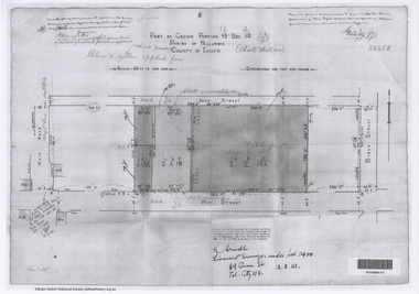
Document - Photocopy, Survey Field Notes of Part of Crown Portion 12, Section 4 at Eltham, Parish of Nillumbik, County of Evelyn, 12 August 1910
Portion of land bounded by: Main Road, John Street, Bible Street, Pitt Street Application 38858 K. Arndt, Licensed Surveyor, 12 August 1910map, neil webster collection, survey plan, surveyor field notes, 1910, application 38858, bible street, john street, main road eltham, pitt street -
 Ringwood and District Historical Society
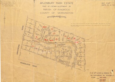
Map - Plan of Subdivision, Aylesbury Park Estate, Part of Crown Allotment 39, Parish of Ringwood, County of Mornington - 1970
Map showing residential allotments for sale in Armstrong Road, Danielle Crescent and Locksley Close, Heathmont, Victoria.Ref.532A Date 13.4.70. Paul Millar & Associates, Land & Engineering Surveyors, 14A Main Street Croydon (Phone) 723 4493. Ref.532A Date 13.4.70. (Agent) H.G. McLean & Assoc P/L, 166 Canterbury Road Heathmont, Phone 8703422 A.H. 8706726 8700112. -
 Ringwood and District Historical Society
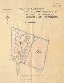
Map - Plan of Subdivision, Part of Crown Allotment 39, Parish of Ringwood, County of Mornington - 1968
Map showing residential allotments numbered 1 to 14 Headline Court, Heathmont, Victoria, off Bronaldi Street and Yallamba Place. Adjoining lot 15 marked as 2 acres 3 roods 29.8 perches with house and garage.Paul Millar & Associates, Land & Engineering Surveyors, First Floor, 14A Main Street Croydon (Phone) 723 4493. Ref. 232B Date 23.1.68 Amended 12.3.68 & 1.12.71. -
 Bendigo Historical Society Inc.
Document - H.A. & S.R. WILKINSON COLLECTION: CONTRACT OF SALE
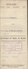
This business was owned by father and son, Henry Archibald Wilkinson and Samuel Ronald "Ron" Wilkinson. Henry (1882-1954) was born in Shepparton and died in Bendigo. He was married to Grace Hovendon in 1908. Samuel Ronald "Ron" (1914-1995), Henry's son, was married to Florence Jean McKerlie in 1937.Contract of sale of land dated 22nd November, 1956 between Mr. W.N. Nicholls (seller) and Mr. G.A. & Mrs. M.L. Quirk (buyers) for piece of land being lot 17 of plan of subdivision No. 33303 lodged in the office of titles being part of Crown allotment 16 section 7A, Kangaroo Flat and situate corner Camp and carpenter Streets, Kangaroo Flat, together with brick veneer dwelling and all sundry, also all electric light fittings and shades. Price 4,500 pounds.organization, business, h.a. & s.r wilkinson real estate -
 Bendigo Historical Society Inc.
Document - H.A. & S.R. WILKINSON COLLECTION: CONTRACT OF SALE
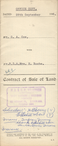
This business was owned by father and son, Henry Archibald Wilkinson and Samuel Ronald "Ron" Wilkinson. Henry (1882-1954) was born in Shepparton and died in Bendigo. He was married to Grace Hovendon in 1908. Samuel Ronald "Ron" (1914-1995), Henry's son, was married to Florence Jean McKerlie in 1937.Contract of sale of land dated 28th September, 1956 between G.A. Cox (seller) and Mr. R.L. & Mrs. E. Roche (buyer) for land being lot 1 on plan of subdivision No. 18242 part of Crown allotment 337 section E described in certificate of title volume 7132 folio 389 and situate no. 150 White Hills Road, Bendigo, together with 5-roomed brick dwelling and all sundry. Price 4,750 pounds.organization, business, h.a. & s.r wilkinson real estate -
 Eltham District Historical Society Inc
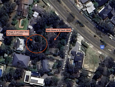
Document - Property Binder, 338 Main Road, Lower Plenty (also 37 Rangeview Road), March 2025
EDHS_03095-338 | EDHS_08635-37 338 Main Road Lower Plenty | 37 Rangeview Road, Lower Plenty Original Mudbrick cottage and studio designed and built by Eltham artist, David Alan Newbury See also EDHS_06090 David Newbury (Artist) David Newbury was married to Clare Margaret Newbury. According to the 1954 Electoral Roll they were living at 36A Murphy Street, South Yarra however around 1953 they purchased Lots 3 and 4 of Main Road Lot Plan LP 23911 in Lower Plenty. A building permit, No. 71, was issued 8 December 1953 for a 5-room house of Vertical Board construction, cost £2,840, builder L. Williams, owner D. Newbury of 36 Murphy Cl., South Yarra. The large house was in fact mostly built of mudbrick, the construction method was only just becoming recognised as an acceptable form in the late 1940s for issuance of a building permit. The house was commenced in 1954, designed by David Newbury and built by David Newbury, Horrie Judd and others. Information from Newbury family friends suggests that a second mudbrick building was constructed in the late 1950s, early 1960s for use as an artist studio by Newbury. The building was connected directly to the water mains at the time and was made suitable for living accommodation during the period Newbury was teaching at Bendigo. Apparently he and Claire rented out the main house during their time in Bendigo and would reside in the studio when visiting Melbourne. No permit for this studio was found in the Building Permit Register, Shire of Eltham, 1949-1960. The last recorded entries in the register are dated May 1960. This would suggest that the studio was constructed post May 1960. It is believed the studio was constructed during the latter period of Newbury’s teaching post in Bendigo so possibly late 1960/1961. In 1963 the Newbury’s address in the Electoral Roll has the property recorded as 220 Main Road, Lower Plenty. Between 1967 to 1980 the Electoral Rolls record the property as 338 Main Road. Today the address is 37 Rangeview Road, Lower Plenty. Contents: 1. Extract from 1942 Shire of Eltham Rate Book. Muriel Gladys Reitsma listed as owner 2. Extract from 1984-85 Shire of Eltham Rate Book for Rangeview Road. (No mention of No. 37 so was probably still listed as 338 Main Road.) 3. Certificate of Title, Vol. 5601 Fol. 1120089 - Issued to David James Graham of Lower Plenty, Builder, Heidelberg for Lot 32 Block B on Plan of Subdivision No. 7606, part of Crown Portion Two, Parish of Nillumbik, County of Evelyn, 29 October 1929 4. Certificate of Title, Vol. 8008 Fol. 076 - Issued to David Alan Newbury of 36 Murphy Street, South Yarra, School Teacher for Lot 3 on Plan of Subdivision No. 23911, part of Crown Portion Two, Parish of Nillumbik, County of Evelyn, 29 October 1953. Amended 24 June 1963 to transfer portion for road widening scheme per Country Roads Board Plan 6889 - Cancelled 24 September 1984 5. Certificate of Title, Vol. 9581 Fol. 583 - Issued to Paul Robert Biber and Althea Constance Biber of 139 Lower Heidelberg Road, Ivanhoe for Lot 3 on Plan of Subdivision No. 23911, part of Crown Portion Two, Parish of Nillumbik, County of Evelyn, 24 September 1984. Derived from Vol. 8008 Fol. 076 L276994V - Cancelled 20 Nov 1992 when subdivided from one to two lots in Vol 10092 Fol. 192 and Vol. 10092 Fol. 193; LP222467B 6. Certificate of Title, Vol. 10092 Fol. 192 - Transfer to Lawrie Mein of 20 Dewar Drive, Hurstbridge of Lot 1 on Plan of Subdivision No. 222467B, lodged 17 Feb 1993, Registered 29 March 1996. Parent Titles Vol 08008 Fol 077, Vol 09581 Fol 583 7. Survey Field Notes of Part of Crown Portion 2, Parish of Nillumbik, County of Evelyn - Portion of land bounded by New Eltham Road. Application 23911 dated 8 Sep 1952 with appended Surveyor Field notes per Application 7098; R.D. Steele, Licensed Surveyor, 18 August 1950 8. Survey Field Notes of Part of Crown Portion 2, Parish of Nillumbik, County of Evelyn - Portion of land bounded by Main Road and Rangeview Road; 2 Lot subdivisions, Vol. 9581 Fol. 583 Part Lot 3 on LP 23911 and Vol. 8008 Fol, 077 Lot 4 on LP 23911; Application 221805 dated 27 November 1989; W.J. Goodison, Licensed Surveyor, and attached Surveyor's Report dated 6 June 1990 (Withdrawn) 9. Survey Field Notes of Part of Crown Portion 2, Parish of Nillumbik, County of Evelyn - Portion of land bounded by Main Road and Rangeview Road; 2 Lot subdivisions, Vol. 9581 Fol. 583 Part Lot 3 on LP 23911 and Vol. 8008 Fol, 077 Lot 4 on LP 23911; Application 222467 dated 20 November 1992 (221805 resubmitted); W.J. Goodison, Licensed Surveyor, and attached Surveyor's Report dated 6 June 1990 Notes: Items 1 to 6 donated electronically Items 7 to 9 sourced from LASSI - SPEAR, Department of Transport and Planning, Victoria State Government, https://maps.land.vic.gov.au/lassi/SpearUI.jsp main road, property, mudbrick, david newbury, phoebe mason collection, rate books, shire of eltham, certificate of title, survey plan, 37 rangeview road, 338 main road, application 23911, lower plenty, map, surveyor field notes, application 221805, application 222467 -
 Eltham District Historical Society Inc
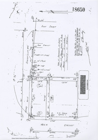
Document - Photocopy, Survey Field Notes of Part of Crown Portion 13, Section 4 at Eltham, Parish of Nillumbik, County of Evelyn, 18 October 1946
Portion of land bounded by: Main Road, Henry Street, Bible Street Application 18650 W. Connolly, Licensed Surveyor, 18 October 1946map, neil webster collection, survey plan, surveyor field notes, 1946, application 18650, bible street, henry street, main road eltham, maria street, rose street -
 Narre Warren and District Family History Group
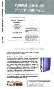
Mixed media, William Hanson, Pastoral possessions of New South Wales, 2006
'Pastoral Possessions of New South Wales' by William Hanson was published in 1889. The book is divided into three sections; the Eastern division, the Central division and the Western division, all containing information on the areas of land owned. Each pastoral holding includes the land district and county in which each pastoral holding is situated, the area in acres, the annual rent and licence fee and the rate per acre and per section for each leasehold and resumed area respectively together with the names of the registered pastoral holders of the crown. The information is detailed and includes the date of notification in the government gazette. This book is useful for local and family historians and for those with interest in or who have ancestors who worked or owned pastoral holdings.1 optical discnon-fiction'Pastoral Possessions of New South Wales' by William Hanson was published in 1889. The book is divided into three sections; the Eastern division, the Central division and the Western division, all containing information on the areas of land owned. Each pastoral holding includes the land district and county in which each pastoral holding is situated, the area in acres, the annual rent and licence fee and the rate per acre and per section for each leasehold and resumed area respectively together with the names of the registered pastoral holders of the crown. The information is detailed and includes the date of notification in the government gazette. This book is useful for local and family historians and for those with interest in or who have ancestors who worked or owned pastoral holdings.new south wales, early pastoralists -
 Mont De Lancey
Souvenir - Souvenir of Gethsemane - Jerusalem, Commonwealth Government, WW11 (1939 - 1945)
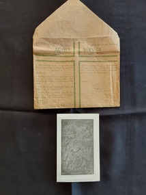
Olive trees have been a boon to civilization for millennia. The oil extracted from olives can be used for everything from fuel for lanterns to medicinal balms to an essential ingredient in foods. It’s easy to understand why the tree was incorporated into so many early religious practices, but near the Mount of Olives in Jerusalem, a grove of olive trees in Gethsemane provides a direct link to ancient biblical stories. At the foot of the Mount of Olives, a small olive grove would go on to become an important site for Christianity. Gethsemane, taken from the Aramaic word for olive press, is mentioned many times throughout the New Testament as a favorite place for Jesus and his disciples to rest and pray beneath the evergreen olive trees. Today, the Church of All Nations has been constructed in a section of Gethsemane, enshrining the ground where Jesus is said to have last prayed.However, as a privilege, soldiers were given one green envelope per month in which they could send uncensored personal and private letters to loved ones. The soldier had to sign to verify that they had only included private and family matters.A small vintage brown paper WWII AUSTRALIAN Active Service envelope with faded green text explaining its use, which was for letters only. It was Revised July 1942. There is a large green lined open cross on the front with Active Service at the top and (Crown Copyright Reserved). It has an address space on the right. Inside the envelope is a small folded paper souvenir from Gethsemene Jerusalem with a black and white image on the front of a relief sculpture depicting the moment when an angel visits Jesus in the garden of Gethsemane. It is titled 'Gethsemeni'. Inside the small souvenir card is a Daily Prayer for the Dying and, glued to the opposite side, an olive leaf from the Garden of Gethsemane. On the back of the souvenir is a text titled, The Good Work of the Holy Land, which describes the work of the Friars Minor who resided in Jerusalem for seven venturies. Though undated, this document dates from WWII when the soldiers were in the Middle East.'Leaf from the Trees of the Garden of Gethsemane' -
 Mont De Lancey
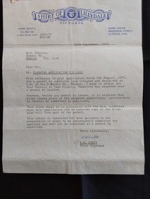
Document - Shire of Lillydale: Planning Application, Shire of Lillydale, 12th September, 1974
Vintage legal documents for land division in Victoria, especially those predating the Torrens system (October 1862), are often found in the Public Record Office Victoria (PROV). These documents, like deeds and Crown grants, can help trace the history of land ownership and division. A letter from K.H. Scott, Shire Engineer of the Shire of Lillydale Victoria to M. H. Proctor Re: Planning Application P.S./833. It is typed on the blue elaborately printed Shire letterhead and dated 12th September, 1974. The application from Mr Proctor to subdivide land situated and described as C.C. 12 Sec B Queens Road., Wandin was granted. Conditions apply.Signed 'Yours faithfully K H Scott K.H. Scott Shire Engineer' 'In reply please quote 1832:74 MGE:DW'legal documents, contracts, documents, indentures -
 Mont De Lancey
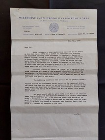
Document - Land Permit to Subdivide Land, Melbourne and Metropolitan Board of Works, 5th July 1974
Vintage legal documents for land division in Victoria, especially those predating the Torrens system (October 1862), are often found in the Public Record Office Victoria (PROV). These documents, like deeds and Crown grants, can help trace the history of land ownership and division. A letter from the Melbourne and Metropolitan Board of Works stating the application by Mr M. H. Proctor of Wandin dated 23rd April, 1974 for a permit to subdivide land in Wandin Yallock has been approved by the Board on 23 April, 1974. There are conditions required. The letter is signed: 'Yours faithfully, (O.T. W. Cosgriff) Assistant Secretary' for 'Mr. M. H. Proctor, Queens Road, Wandin, 3139. 'Board's Reference: Appln No, TP 76484'legal documents, contracts, documents, indentures -
 Ringwood and District Historical Society
Document - Subdivision Map, Part of Crown Sections 18, 19, 24 & 25, Parish of Warrandyte, County of Evelyn, Vol 5228 Fol 472 - 1926. (Park Orchards, Victoria)
A3 and A4 sized photocopies showing map section of land title showing streets, easements and allotment numbers, some with handwritten names and pricing notations circa mid 1950s.Map includes Valley Road, Granard Avenue, Park Road, Arundel Avenue, Hylton Avenue, Aviemore Avenue, Bowmore Avenue, Hopetoun Road, Colin Avenue, Daintree Avenue, Brucedale Crescent, Feversham Avenue, Ennismore Crescent, Iona Grove, Elgin Crescent and Gosford Crescent, Park Orchards, Victoria. -
 Ringwood and District Historical Society
Document, Plan of Subdivision - Part of Crown Portion 5, Parish of Ringwood, County of Bourke - (Undated)
Map showing layout of 4 numbered allotments coloured red and land coloured blue appropriated or set aside for drainage and sewerage puposes.Map includes Nelson Street and Ringwood Street, Ringwood, Vic. -
 Eltham District Historical Society Inc
Document - Property Binder, 616 Main Road, Eltham; Plum Cottage
Plum Cottage is covered by Heritage Overelay HO256 in the Nillumbuk Planning Scheme This two-lot land holding was created as a subdivision and sold to Charles Stuart McNeil by May 1955. Sometime in the period 1955-1960, the builder-designer, John Harcourt had created a pise house on the site, straddling the two subdivision lots. The designer, John M. Harcourt was a pioneer builder in pise-de-terre and mudbrick in the Eltham Shire, Eltham being synonymous with alternative lifestyles and building practises until the onset of suburbia in the late 20th and early 21st centuries. This hipped-roof house is set high above Main Road on a V-shape plan characteristic of the Arts & Crafts style, with rammed earth or pise walls, timber joinery and a cement tiled roof. The V shape plan was used by important English and Eltham Arts & Crafts designers. The use of natural materials such as stone and timber construction is an essential part of the Arts & Crafts style and Harcourt’s work. So too is the application of the style on both the exterior and interior of the house as a holistic concept. The house adjoins the Lim Joon adobe house built and designed by Alistair Knox in the same era (HO119), thus forming a distinctive pair, both using an uncommon plan form. This house was identified in the Shire of Shire of Eltham Heritage 1992 as contributory to the Eltham Gateway Conservation Area, then proposed as an urban conservation area (now Heritage Overlay Area). Land Ownership Emily Jane Smith of 12 Woodside Street Fitzroy owned Crown Allotments 1 & 2 Sections 14, 27 by August 1918, selling to William Henry Smith of 12 Woodside Street, Nth Fitzroy May 1921. (John) James Isherwood of Main Road, Eltham owned the property by 1928 (the year of his death) with the beneficiary of his estate and next owner of this site being his widow, Minnie Maria Isherwood of Cemetery Road, Eltham. His holding in Main Road included parts of what was described in rate records as allotments1 & 2 Section E6. In the late 1930s, early 1940s her son Alfred John Isherwood was also rated for the land around this site, with the rated nett annual value varying between £2 and £5. Alfred Isherwood also lived at Main Road, Eltham with his wife Ellen: her early death at the age of 24 was reported in the Argus of 1923. Part of the Isherwood land was divided off and sold to Charles Stuart McNeil by May1955. Sometime in the period 1955-1960, the builder-designer, John Harcourt had created a pise house on the site, straddling the two subdivision lots. The house is visible on an aerial photograph from 1960s. Reputedly the house was called Plum Cottage and erected for Harcourt’s mother-in-law. A garage was added in 1959. Charles McNeil died in1971 aged 87: he was the son of Don McNeil and Margaret Arkell. Available rate records from the construction era start in the of the 1970s (1972-3) and list Mr H.C. & M/S A.V. Charity at 616 Main Road Eltham of this property with a nett annual value of $740. More recent valuer's data describes the property as lots 1 & 2 LP25668, located in the Central Riding of Eltham Shire, owned by Ann Valerie Charity and later, in 1990, by the Chincarini family. Building Description This hipped roof 11 .5 square house is set high above Main Road on a characteristic-shape plan and has rammed earth or pise walls, timber joinery and a cement tiled roof. The V-shape plan was used by Important designers such as C.F.A. Voysey (UK) who interpreted medieval domestic architecture as part of the Arts & Crafts style of the late 19th and early 20th centuries. The pise walls are covered with a textured render while the cement roofing tiles are also seen in the Harcourt Hill examples. Reputedly the ceiling joists are of a deep section and span long lengths with no need for hanging beams in the roof space. The ceilings are low and panelled in main rooms with apparently Caneite soft board infill panels between the exposed ceiling beams. These are painted white but may have been stained at one time. The focus of the house is the large living area with its vast random stone fireplace. Significance Plum Cottage is significant to the locality of Eltham because: Historically: • Plum Cottage is closely associated with the important historical theme of earth construction evident in Eltham and elsewhere in the Shire since theear1y Arts & Crafts inspired creations at Penleigh Boyd's The Robins (1912, HO101) and those at Montsalvat (1934-, HO82) but more prominent from the Second War period when earth building in Eltham was promoted in national periodicals as an alternative building method that avoided the building materials shortages of that era; • The choice of the earth building technique also expresses the theme of refuge or alternative living, synonymous with Eltham in the early to mid 20th century; • as a good example of domestic architecture from John Harcourt who was the first major post Second War figure in an important phase of Eltham’s earth building development, using his characteristic Old English or Arts& Crafts style that relies in this case on the pise wall construction, pitched roof forms, exposed ceiling joists, half timbering, random stonework, and panelled internal wall finishes. Architecturally: • Plum Cottage's pise wall construction is uncommon among the early earth-walled structures in the Shire, that are mainly of adobe or mud brick, and as a building material is uncommon among the Shire’s suburban dwellings generally which are clad typically with either fired clay bricks or timber boarding. Aesthetically: • Plum Cottage is a good and well preserved example of a modern Old English or Arts & Crafts style earth-walled building in the Shire • For the proximity of the significant Lim Joon adobe house designed by Alistair Knox adjoining to the north, providing a distinctive earth wall house pair, with uncommon plan forms. Reference Heritage Assessment of Plum Cottage, 616 Main Road, Eltham; Graeme Butler & Associates 2010main road, eltham, property, houses, (john) james isherwood, alfred john isherwood, ann valerie charity, arts and crafts style, charles stuart mcneil, chincarini family, eltham gateway zone, emily jane smith, h.c. charity, heritage assessment, john harcourt, john m. harcourt, lim joon house, main road eltham, minnie maria isherwood, pise construction, plum cottage -
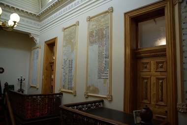 Old Colonists' Association of Ballarat Inc.
Photograph - Photograph - Colour, The entrance foyer of the Old Colonists' Club, 2015
From the Argus Newspaper of 10 May 1888: "OLD COLONISTS' ASSOCIATION OF BALLARAT. (FROM OUR CORRESPONDENT.) BALLARAT, WEDNESDAY. This association, which was founded in August, 1883, and at first known as the Old Identities' Association, now has a roll of 450 members. The objects of the association are "to aid and assist indigent or suffering old colonists; to raise a fund, by the voluntary subscriptions of the members and the aid of outside donations, for the purpose of relieving members in sickness and old age ; for assisting those in extreme distress, to provide the shelter o a home for old and indigent pioneers of the gold fields, their widows, or anyone connected with the association, and in the event of the death of any member to have his remains decently buried, the association defraying the expenses of the funeral (providing that no funds or property are left by the deceased), and to attend the funeral if so desired by the relatives " The qualifications for member- ship are good character and repute, and residence in the colonies for a quarter of a century. For some time the association had no property except the regular subscriptions, but about a year ago they obtained from the Minister of Lands the grant of a very valuable block of land in Lydiard-street, the Crown grant of which they received last week. This block has a frontage of 66ft to Lydiard street, worth at least £100 a foot. The ground was given to the association as a site for them to build a hall upon, and with so valuable an asset they had no difficulty in borrowing at 7 per cent, enough money to construct a hall. For revenue purposes the ground floor of the building has been made into four shops, and the rental from these, judging from the rentals of shops in the vicinity, will not only pay all the interest on the borrowed money, but over £200 a year towards clearing off the principal. The officers of the association are Messrs J P Murray, president; J W Graham and T. Stoddart, vice presidents; D Fern, treasurer , and J Fraser, secretary. The Old Colonists' Hall is an elegant looking building in Lydiard-street, lying between the newly-opened mining exchange and the Commercial Club house, and a few doors north of the Post office. The style of the facade is classic. The lower portion of the front is constructed of Waurn Ponds stone, forming piers, and the upper portion of brick and cement, the background being tuckpointed. The centre bay is carried by two three quarter columns with Ionic cups, which support a pediment on which is set a cast of the Ballarat coat of arms. The four other bays are supported by pilasters with Corinthian caps mid partly fluted. The entrance is through a spacious circular headed doorway, the keystone of the arch of which bears a sculptured head, in marble, representing that of the president of the Old Colonists' Association here, Mr. John P Murray. An ample vestibule leads to a wide stone staircase which ends at a spacious landing. The landing has a dome over the centre, with cornice and enrichments, and is lighted from above. The walls round the landing are panelled with marble slabs, which are to be appropriately inscribed in the future. On the first door are the rooms appropriated to the association. The principal of these is a hall 44ft x 33ft and 17ft high. This room is well ventilated and lighted from the back of the building with large windows, and the walls are finished with Keene's cement. The other rooms are committee room, 14ft x 16ft; scretary's, 14ft x 17ft 6in; kitchen, bedrooms, bathroom, &c. The front portion of the first floor is arranged so that it may be let for offices, or utilised for club purposes. Suitable provision has been made throughout tor lighting, ventilation, and means of egress. The architect for the edifice is Mr A. G Legge, of this city, and the contractors are Messrs. Whitelaw and Atkinson, Irving and Glover, Reynolds, and J Donaldson. The total cost of the building when completed, which will be in a few weeks, will be about £4,000."Colour photograph of a room with marble plaques on the wall. They relate to the Old Colonists' Association of Ballarat, old colonists' association ballarat, old colonists' club, marbles -
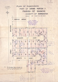 Ringwood and District Historical Society
Document, Plan of Subdivision - Part of Crown Portion 7, Parish of Ringwood, County of Mornington - 1962
Map of residential allotments coloured red, with land coloured blue set apart for drainage & sewerage easements. Rubber stamped J.P. Tuohy, Licensed Surveyor, 25 Howe Street Murrumbeena, Tel. 561945, dated 38.8.1962.Map includes Maidstone Street, Norfolk Avenue, Stanhope Court and Wrights Court, Ringwood, Vic. Also includes handwritten Estate Agent sales notations. -
 Ringwood and District Historical Society
Document - Plan of Subdivision, Part of Crown Allotment 31B, Parish of Warrandyte - 1965
Map showing residential allotments numbered 1, 2, 4 and 5, on Through Road, Ringwood, Vic., with property dimensions, including weatherboard house and galvanised iron garage on lot 2.Kirkpatrick & Webber, Licensed Surveyors, Civil Engineers & Town Planners, Maroondah Highway, Ringwood, Telephone 8700321. Ref 3438C. Date 4th December, 1964. Amended 19th July, 1965. Notation: "The land coloured blue is a drainage and sewerage easement. Levels are to Board of Works Datum. Lot number 3 has been omitted." -
 University of Melbourne, Burnley Campus Archives
Plan, Plan of Richmond Park, 1886-1948
(1) Black and white photographed copy of an original coloured plan. Plan of Richmond Park with Horticultural Society Gardens marked in. Includes additional land which became the Field Station. Original plan dated 31 August 1872, note of Crown Grant to the Board of Land & Works and Richmond City Council 1886; showing land, "Permanently Preserved for the Gardens". Stamp, "Department of Lands and Survey Photographed at the Central Plan Office 1/1 Plate 7.12.48" (2) Also 2 photocopies, 1 reduced - possibly used in a publication1 photocopy has "Figure 1. Plan of Burnley Gardens circa 1863 [sic]gardens, richmond, horticultural society of victoria, richmond park, a.l. martin -
 Bendigo Historical Society Inc.
Document - INDENTURE, GOLD MINING LEASE 11081 CROWN AND HERBERT JACKSON LEED OF BENDIGO, MCCOLL, RANKIN AND STANISTREET COLLECTION, 21st September, 1940
Six page document plus map, dated 21st September 1940, between the Crown and Herbert Jackson Leed, for the land shown on the accompanying map 'indicated by yellow colour' Depths indicated on lease document. On map: Mining District of Bendigo, County of Bendigo, Parish of Sandhurst. No. 11081. Net Area 24 acres, 3 roods, 3 perches. Signed by Herbert Leed and ?Walsh, Warden Clerk, Bendigo. Map shows lease holding 11081 coloured yellow. Other leases: no's. 9882 11081, 11034, 11080. Streets: Fletcher Street, and Belle Vue Road. Gullies: Derwenters Mistake Bully and Pig Face Gully on lease 11081. Quarry Hill Recreation Reserve marked and some residential allotments. Water race indicated on map. On back of document: ; Deborah United Gold Mining Company No Liability of Charing Cross Bendigo is now the proprietor of the within described estate by transfer registered on 21st November 1940 and numbered 1795202.bendigo, mining, deborah united gold mine, herbert jackson leed, deborah united gold mining. major general sir winston joseph dugan -
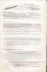 Bendigo Historical Society Inc.
Document - MCCOLL, RANKIN AND STANISTREET COLLECTION: INDENTURE GOLD MINING LEASE 9201 BALLAARAT
6 page document plus map: indenture, gold mining lease dated 9th August 1960, between the Crown and North Deborah Mining Company, carrying on operations in the Parish of Moorarbool West . Key on map indicates depth to which land may be excised. On map: Mining District of Ballarat, County of Grant, Parish of Moorarbool West. Total area: 285 acres 1 rood, 20 perches. Vol 334, Fol 202.bendigo, mining, deborah gold mines -
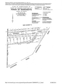 Ringwood and District Historical Society
Document - Subdivision Plan, LP7604 Part of Crown Portion 31B, Parish of Warrandyte, County of Evelyn, Vol 3954 Fol 626 - 2019
A4 LANDATA Land Victoria plan printout dated 2010Map includes Derwent Street and Warrandyte Road, Ringwood. Although marked See Sheet 2, no other page included with collection. -
 Bendigo Historical Society Inc.
Legal record - FEATONBY Mrs Anne - Sale Note, Watson, James & Rogers, Rogers Collection, 10.02.1920
In the early 1980s the firm of Watson, James & Rogers merged with the partnership of Every & Every and became the iconic “Rogers & Every” as known today. The firm is still located on Bull Street. https://rogersevery.com.au/about/FEATONBY, Mrs Anne Sale note re Crown Allotment 4, Parish of Warriwitue County of Dalhousie. Cream coloured paper.Signatures.sale note, sherriff, featonby, public auction, land sale, nicholas kennedy -
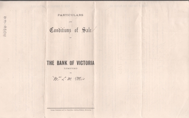 Bendigo Historical Society Inc.
Legal record - ELLIS Edward Woodrow Tregenza - Land sale records, Watson, James & Rogers, Rogers Collection, 1907
In the early 1980s the firm of Watson, James & Rogers merged with the partnership of Every & Every and became the iconic “Rogers & Every” as known today. The firm is still located on Bull Street. https://rogersevery.com.au/about/* Particulars, conditions of sale and contract from bank of Victoria to Louisa Mary Ellis. 1907. * Plan of subdivision of crown allotments 20, 22, 23 Parish of Sandhurst, County of Bendigo * Agreement between Rupert Noyes Putnam of Williamson St. Bendigo and Edward Woodrow Tregenza Ellis of High St Bendigo for Crown allotments 18 and 19, Parish of Sandhurst County of bendigo.Signaturesrupert noyes putnam, land sales -
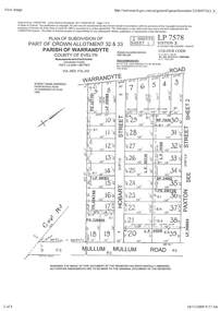 Ringwood and District Historical Society
Document - Subdivision Plan, Part of Crown Allotment 32 & 33 Parish of Warrandyte, County of Evelyn Vol 3922 Fol 242
LANDATA Land Victoria 2-sheet plan printout dated 16/6/1919.Sheet 1 includes Warrandyte Road, Hobart Street, Paxton Street, and Mullum Mullum Road, Ringwood, Vic. Additional markings include PS327701, LP215189, RP7936, LP110103, LP36735, LP31149, SP24012, PS310739, PS326740, PS336885, LP41558. Sheet 2 includes Warrandyte Road, Paxton Street, Arnold Street, and Mullum Mullum Road, Ringwood, Vic. Additional markings include RO270, SP26622, LP50242, RP19467, SP27005, SP31440, PS312181.