Showing 1531 items matching "high street road"
-
 Kew Historical Society Inc
Photograph - City of Kew steamroller and workers, c. 1960
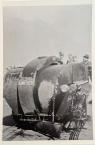
Tom Bentley (1912-1993) was born in Lancashire (UK). From circa 1951, he was the Overseer/Superintendent of Outdoor Works for Kew City Council. Until his retirement in the 1970s, he was based at the Kew Council Depot, located in the former MTB Horse Tram Depot on the corner of Disraeli and High Streets, Kew. Accompanying the set of twelve photographs is a 12-page illustrated biography of the Bentley and Plumridge families, separately kept in the 'Bentley' subject file.Duplicate black and white positive print photograph of road works in Studley Park Road, Kew, carried out under the supervision of Tom Bentley, Overseer/Superintendent of Outdoor Works for the City of Kew. The photograph shows a Council-owned steamroller used for road construction.city of kew, public works, tom bentley, road works, steamrollers -
 Kew Historical Society Inc
Photograph - Road construction in Studley Park Road, c. 1960
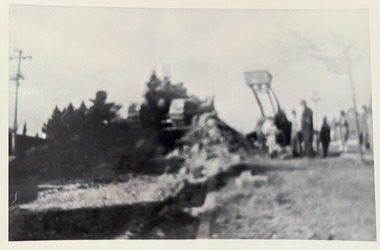
Tom Bentley (1912-1993) was born in Lancashire (UK). From circa 1951, he was the Overseer/Superintendent of Outdoor Works for Kew City Council. Until his retirement in the 1970s, he was based at the Kew Council Depot, located in the former MTB Horse Tram Depot on the corner of Disraeli and High Streets, Kew. Accompanying the set of twelve photographs is a 12-page illustrated biography of the Bentley and Plumridge families, separately kept in the 'Bentley' subject file.Duplicate black and white positive print photograph of road works in Studley Park Road, Kew, carried out under the supervision of Tom Bentley, Overseer/Superintendent of Outdoor Works for the City of Kew. The blurred photograph shows Council-owned vehicles used for road construction and council workers.city of kew, public works, tom bentley, road works -
 Kew Historical Society Inc
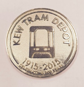
Souvenir - Medallion, Kew Tram Depot 1915-2015, 2015
... and High Street, Kew, a suburb of Melbourne, Australia. Operated... tram depot is located on the corner of Barkers Road and High ...Kew tram depot is located on the corner of Barkers Road and High Street, Kew, a suburb of Melbourne, Australia. Operated by Yarra Trams, it is one of eight tram depots on the Melbourne tram network. The depot opened on 8 May 1915.Commemorative medallion in blue presentation box, given to the Kew Historical Society on the anniversary of the Kew Depot in 2015.Front: Schematic engraving of tram with the words "Kew Tram Depot : 1915-2015 : Celebrating 100 Years". Reverse: Schematic engraving of exterior of Depot, surrounded by the words "Commemorating all staff who have contributed to the success of Kew Depot".kew tram depot, commemorative medallions, tramways memorabilia -
 Kew Historical Society Inc
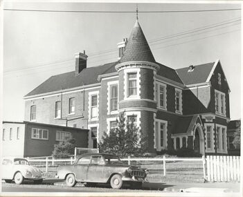
Photograph, Kew RSL, Cotham Road, circa 1965, c. 1965
The Kew RSL is located in "Wilton" House, 63 Cotham Road. The RSL was established on January 1st 1920, later joining with the Hawthorn RSL. In November 1931, Cr. C.R. Parry organised the reformation of the Kew Sub Branch and its first president was Brig-Gen Pat McGlin, a veteran of the Boer War and the First World War. On July 17th 1932, the club rooms first opened on Army land at the corner of High Street and Highbury Grove. In late November 1948, the Kew RSL bought the "Wilton" house from the Kew City Council for £10,067, opening seven years later in July 1955. [Source: Victorian Heritage Database]This work forms part of the collection assembled by the historian Dorothy Rogers, that was donated to the Kew Historical Society by her son John Rogers in 2015. The manuscripts, photographs, maps, and documents were sourced by her from both family and local collections or produced as references for her print publications. Many were directly used by Rogers in writing ‘Lovely Old Homes of Kew’ (1961) and 'A History of Kew' (1973), or the numerous articles on local history that she produced for suburban newspapers. Most of the photographs in the collection include detailed annotations in her hand. The Rogers Collection provides a comprehensive insight into the working habits of a historian in the 1960s and 1970s. Together it forms the largest privately-donated collection within the archives of the Kew Historical Society.The exterior of the Kew RSL on the corner of Cotham Road and Charles Street, Kew. Designed by Guyon Purchase for Dr. William Walsh in 1886, the building was originally called Wilton."Chap 59. Cotham Rd. Built/Commences about 1885-6. Present day Wilton . Kew RSSUILA rooms. (Rumour of sale 1972?)"wilton, dr william walsh, guyon purchas, dorothy rogers, cotham road (kew) -
 Kew Historical Society Inc
Plan - Subdivision Plan, Golf View Estate, c.1922
Pru Sanderson, in her groundbreaking ‘City of Kew Urban Conservation Study : Volume 2 - Development History’ (1988), summarised the periods of urban development and subdivisions of land in Kew. The periods that she identified included 1845-1880, 1880-1893, 1893-1921, 1921-1933, 1933-1943, and Post-War Development. These periods were selected as they represented periods of rapid growth or decline in urban development. An obvious starting point for Sanderson’s groupings involved population growth and the associated economic cycles. These cycles also highlighted urban expansion onto land that was predominantly rural, although in other cases it represented the decline and breakup of large estates. A number of the plans in the Kew Historical Society’s collection can also be found in other collections, such as those of the State Library of Victoria and the Boroondara Library Service. A number are however unique to the collection.The Kew Historical Society collection includes almost 100 subdivision plans pertaining to suburbs of the City of Melbourne. Most of these are of Kew, Kew East or Studley Park, although a smaller number are plans of Camberwell, Deepdene, Balwyn and Hawthorn. It is believed that the majority of the plans were gifted to the Society by persons connected with the real estate firm - J. R. Mathers and McMillan, 136 Cotham Road, Kew. The Plans in the collection are rarely in pristine form, being working plans on which the agent would write notes and record lots sold and the prices of these. The subdivision plans are historically significant examples of the growth of urban Melbourne from the beginning of the 20th Century up until the 1980s. A number of the plans are double-sided and often include a photograph on the reverse. A number of the latter are by noted photographers such as J.E. Barnes.The subdivision advertised as the Golf View Estate in Camberwell included 32 allotments bordering on Glen Iris Road, Smith Street (now Smith Road), St Andries Street and Camberwell Road. In the post-war period in which the subdivision took place, the significance of Camberwell as the ‘Heathiest of Suburbs’ because of the undulating nature of its terrain and its high altitude was promoted. The sales pitch aimed at attracting and selling to ‘Gentlemen’ who could take advantage of the nearby trams, which would take them to the ‘heart of the city’.subdivision plans - camberwell, golf view estate -
 Kew Historical Society Inc
Plan - Subdivision Plan, Shop Sites, East Kew, c.1927
Subdivision plans are historically important documents used as evidence of the growth of suburbs in Australia. They frequently provide information about when the land was sold on which a built structure was subsequently constructed as well as evidence relating to surveyors and real estate and financial agents. The numerous subdivision plans in the Kew Historical Society's collection represent working documents, ranging from the initial sketches made in planning a subdivision to printed plans on which auctioneers or agents listed the prices for which individual lots were sold. In a number of cases, the reverse of a subdivision plan in the collection includes a photograph of a house that was also for sale by the agent. These photographs provide significant heritage information relating house design and decoration, fencing and household gardens.This is one of a small number of subdivision plans for commercial property in the collection. The subdivision proposed to create six shop sites in High Street between the Harp of Erin and Station Street. The plan shows this stretch of High Street, East Kew already lined with shops that include the hotel on the corner, the new State Savings Bank, a dentist’s surgery and Lambert’s Store. The High Street Tram was to reach Burke Road in 1925, so the proposed subdivision must postdate that event, and the opening of the Bank in 1926.subdivision plans - east kew, high street - east kew -
 Kew Historical Society Inc
Plan - Subdivision Plan, Eastlawn Estate, 1914
Subdivision plans are historically important documents used as evidence of the growth of suburbs in Australia. They frequently provide information about when the land was sold on which a built structure was subsequently constructed as well as evidence relating to surveyors and real estate and financial agents. The numerous subdivision plans in the Kew Historical Society's collection represent working documents, ranging from the initial sketches made in planning a subdivision to printed plans on which auctioneers or agents listed the prices for which individual lots were sold. In a number of cases, the reverse of a subdivision plan in the collection includes a photograph of a house that was also for sale by the agent. These photographs provide significant heritage information relating house design and decoration, fencing and household gardens.The ‘Eastlawn Estate’ was surveyed and ready for auction in March 1914, three months before the outbreak of World War I. Sixty-six allotments, created on the ‘order of Mr & Miss Preston’ surrounded the mansion of Woodlands in Harp Road. Woodlands formed part of the Estate, being advertised as lot 1. The allotments faced High, Station and Wright Streets, Harp and Normanby Roads, and Woodlands Avenue. Pru Sanderson in the Kew Conservation Study (Vol.2, 1988) wrote that the Eastlawn Estate ‘covered the western half of the failed Harp of Erin Estate’. Contemporary advertisements promoted the Eastlawn Estate as: ‘There will be no more convenient district nor pleasant Suburb than East Kew for the busy business man. When the Electric Tram is laid, he will be able to journey quickly and pleasantly direct from Collins Street to his home in the Eastlawn Estate in about 20 minutes’. The actual plans of subdivision were included in advertisements in The Argus and in the local newspapers.subdivision plans - east kew, eastlawn estate -
 Kew Historical Society Inc
Plan - Subdivision Plan, Harvest Home Estate, 1919
Pru Sanderson, in her groundbreaking ‘City of Kew Urban Conservation Study : Volume 2 - Development History’ (1988), summarised the periods of urban development and subdivisions of land in Kew. The periods that she identified included 1845-1880, 1880-1893, 1893-1921, 1921-1933, 1933-1943, and Post-War Development. These periods were selected as they represented periods of rapid growth or decline in urban development. An obvious starting point for Sanderson’s groupings involved population growth and the associated economic cycles. These cycles also highlighted urban expansion onto land that was predominantly rural, although in other cases it represented the decline and breakup of large estates. A number of the plans in the Kew Historical Society’s collection can also be found in other collections, such as those of the State Library of Victoria and the Boroondara Library Service. A number are however unique to the collection.The Kew Historical Society collection includes almost 100 subdivision plans pertaining to suburbs of the City of Melbourne. Most of these are of Kew, Kew East or Studley Park, although a smaller number are plans of Camberwell, Deepdene, Balwyn and Hawthorn. It is believed that the majority of the plans were gifted to the Society by persons connected with the real estate firm - J. R. Mathers and McMillan, 136 Cotham Road, Kew. The Plans in the collection are rarely in pristine form, being working plans on which the agent would write notes and record lots sold and the prices of these. The subdivision plans are historically significant examples of the growth of urban Melbourne from the beginning of the 20th Century up until the 1980s. A number of the plans are double-sided and often include a photograph on the reverse. A number of the latter are by noted photographers such as J.E. Barnes.The ‘Harvest Home Estate’ was advertised as being a subdivision in East Kew. Now, Campbell and Owen Streets on which the allotments were located are classed as being in Kew. The Estate included 11 residential allotments abutting the Outer Circle Railway line [at the end of Owen Street]. Understandably, the vendors focused on the availability of transport by tram, noting that the Estate was near the High Street tram terminus at the Harp of Erin. A small note on the subdivision advises that the Cotham Road tram was only 3 minutes away. The location – ‘The most elevated position in lovely Kew’ – was also promoted as an advantage.subdivision plans - east kew, harvest home estate -
 Kew Historical Society Inc
Plan, J R Mathers & McMillan, 5 Splendid vVlla Allotments,: Segtoune St. & Windsor St., Kew, 1928
Prue Sanderson, in her groundbreaking ‘City of Kew Urban Conservation Study : Volume 2 - Development History’ (1988), summarised the periods of urban development and subdivisions of land in Kew. The periods that she identified included 1845-1880, 1880-1893, 1893-1921, 1921-1933, 1933-1943, and Post-War Development. These periods were selected as they represented periods of rapid growth or decline in urban development. An obvious starting point for Sanderson’s groupings involved population growth and the associated economic cycles. These cycles also highlighted urban expansion onto land that was predominantly rural, although in other cases it represented the decline and breakup of large estates. A number of the plans in the Kew Historical Society’s collection can also be found in other collections, such as those of the State Library of Victoria and the Boroondara Library Service. A number are however unique to the collection.Subdivision plans are historically important documents used as evidence of the growth of suburbs in Australia. They frequently provide information about when the land was sold on which a built structure was subsequently constructed as well as evidence relating to surveyors and real estate and financial agents. The numerous subdivision plans in the Kew Historical Society's collection represent working documents, ranging from the initial sketches made in planning a subdivision to printed plans on which auctioneers or agents listed the prices for which individual lots were sold. In a number of cases, the reverse of a subdivision plan in the collection includes a photograph of a house that was also for sale by the agent. These photographs provide significant heritage information relating house design and decoration, fencing and household gardens.In 1928, five residential allotments bordering Segtoune and Windsor Streets were advertised for sale as part of a subdivision. Four of the blocks faced Segtoune Avenue. The auctioneers proclaimed the advantages of the sites: ‘Situate one minute from the High Street Electric Tram, which now runs direct to Spencer Street via Bridge Road and Flinders Street. Opposite the East Kew Railway Station (Outer Circle Line), which may be reopened In connection with the new Line from Kew to Doncaster; Adjacent lo the Kew Recreation Reserve, Sports Oval, and Swimming Bath; Half Minute from the Shopping Centre of East Kew, Accessible to the State School and Other Educational Centres’. The Harp of Erin Hotel and the route of the Outer Circle Railway line are marked on the plan. The Recreation Reserve and Sport Oval refer to Victoria Park. The Swimming Baths were located on the site of the current Kew Recreation Centre.subdivision plans - kew, segtoune street -- kew (vic.), windsor street -- kew (vic.) -
 Kew Historical Society Inc
Plan - Subdivision Plan, High Street, Kew, 1920-1935
Pru Sanderson, in her groundbreaking ‘City of Kew Urban Conservation Study : Volume 2 - Development History’ (1988), summarised the periods of urban development and subdivisions of land in Kew. The periods that she identified included 1845-1880, 1880-1893, 1893-1921, 1921-1933, 1933-1943, and Post-War Development. These periods were selected as they represented periods of rapid growth or decline in urban development. An obvious starting point for Sanderson’s groupings involved population growth and the associated economic cycles. These cycles also highlighted urban expansion onto land that was predominantly rural, although in other cases it represented the decline and breakup of large estates. A number of the plans in the Kew Historical Society’s collection can also be found in other collections, such as those of the State Library of Victoria and the Boroondara Library Service. A number are however unique to the collection.The Kew Historical Society collection includes almost 100 subdivision plans pertaining to suburbs of the City of Melbourne. Most of these are of Kew, Kew East or Studley Park, although a smaller number are plans of Camberwell, Deepdene, Balwyn and Hawthorn. It is believed that the majority of the plans were gifted to the Society by persons connected with the real estate firm - J. R. Mathers and McMillan, 136 Cotham Road, Kew. The Plans in the collection are rarely in pristine form, being working plans on which the agent would write notes and record lots sold and the prices of these. The subdivision plans are historically significant examples of the growth of urban Melbourne from the beginning of the 20th Century up until the 1980s. A number of the plans are double-sided and often include a photograph on the reverse. A number of the latter are by noted photographers such as J.E. Barnes.A roughly drawn and faded actual or projected subdivision of a parcel of land bordering on High and Mary Streets. The plan shows five allotments facing High Street and at their rear, another allotment facing Mary Street. In 1906, when the Board of Works surveyors completed Detail Plan 1589, the allotment in Mary Street is shown to include a building. The section of land attached to this building is shown to be undeveloped, thus making a further subdivision possible.subdivision plans - kew, high street -- kew (vic.), mary street -- kew (vic.) -
 Kew Historical Society Inc
Plan - Subdivision Plan, Boulevard Estate - Boulevard Section, 1930-1936
... ). The subdivision plan is of interest in that it names High Street in Kew...). The subdivision plan is of interest in that it names High Street in Kew ...Pru Sanderson, in her groundbreaking ‘City of Kew Urban Conservation Study : Volume 2 - Development History’ (1988), summarised the periods of urban development and subdivisions of land in Kew. The periods that she identified included 1845-1880, 1880-1893, 1893-1921, 1921-1933, 1933-1943, and Post-War Development. These periods were selected as they represented periods of rapid growth or decline in urban development. An obvious starting point for Sanderson’s groupings involved population growth and the associated economic cycles. These cycles also highlighted urban expansion onto land that was predominantly rural, although in other cases it represented the decline and breakup of large estates. A number of the plans in the Kew Historical Society’s collection can also be found in other collections, such as those of the State Library of Victoria and the Boroondara Library Service. A number are however unique to the collection.The Kew Historical Society collection includes almost 100 subdivision plans pertaining to suburbs of the City of Melbourne. Most of these are of Kew, Kew East or Studley Park, although a smaller number are plans of Camberwell, Deepdene, Balwyn and Hawthorn. It is believed that the majority of the plans were gifted to the Society by persons connected with the real estate firm - J. R. Mathers and McMillan, 136 Cotham Road, Kew. The Plans in the collection are rarely in pristine form, being working plans on which the agent would write notes and record lots sold and the prices of these. The subdivision plans are historically significant examples of the growth of urban Melbourne from the beginning of the 20th Century up until the 1980s. A number of the plans are double-sided and often include a photograph on the reverse. This plan shows a subdivision with two sections: the ‘Boulevard Section’ and the ‘Riverside Section’. The first of these sections bordered Burke Road between Kilby Road and the farm beside the Yarra. Kilby Road, Munro Road, Burke Road and Old Burke Road bordered the 102 lots in the Boulevard Section of the plan. The streets within the Section included Walbundry Avenue, Inverness Way, Riverside Avenue, Cascade Street and Kyora Parade. These street names, at least in this subdivision plan linked the two Sections of the subdivision. At a later date, the City of Kew decided to alter the street names. Walbundry, Inverness, Riverside, Cascade and Kyora were all renamed as ‘Drives’ (e.g. Kyora Drive). The subdivision plan is of interest in that it names High Street in Kew as Doncaster Road. It also shows the location of the wooden church that was later removed to Yarraville on the corner of Kilby Road and High Street. The plan predates later developments such as the S. E. Dickens Supermarket.subdivision plans - east kew, boulevard estate, munro road -- kew east (vic.), kilby road -- kew east (vic.), burke road -- kew east (vic.), walbundry avenue -- kew east (vic.), inverness way -- kew east (vic.), riverside avenue -- kew east (vic.), cascade drive -- kew east (vic.), nyora parade -- kew east (vic.) -
 Kew Historical Society Inc
Plan - Subdivision Plan, Goldthorns Hill Estate, 1925
... of the Burke Road tram to High Street. Discerning buyers were advised... extension of the Burke Road tram to High Street. Discerning buyers ...Pru Sanderson, in her groundbreaking ‘City of Kew Urban Conservation Study : Volume 2 - Development History’ (1988), summarised the periods of urban development and subdivisions of land in Kew. The periods that she identified included 1845-1880, 1880-1893, 1893-1921, 1921-1933, 1933-1943, and Post-War Development. These periods were selected as they represented periods of rapid growth or decline in urban development. An obvious starting point for Sanderson’s groupings involved population growth and the associated economic cycles. These cycles also highlighted urban expansion onto land that was predominantly rural, although in other cases it represented the decline and breakup of large estates. A number of the plans in the Kew Historical Society’s collection can also be found in other collections, such as those of the State Library of Victoria and the Boroondara Library Service. A number are however unique to the collection.The Kew Historical Society collection includes almost 100 subdivision plans pertaining to suburbs of the City of Melbourne. Most of these are of Kew, Kew East or Studley Park, although a smaller number are plans of Camberwell, Deepdene, Balwyn and Hawthorn. It is believed that the majority of the plans were gifted to the Society by persons connected with the real estate firm - J. R. Mathers and McMillan, 136 Cotham Road, Kew. The Plans in the collection are rarely in pristine form, being working plans on which the agent would write notes and record lots sold and the prices of these. The subdivision plans are historically significant examples of the growth of urban Melbourne from the beginning of the 20th Century up until the 1980s. A number of the plans are double-sided and often include a photograph on the reverse. The Goldthorns Hill Estate subdivision was first put up for auction in 1925. The subdivision took its name from the mansion ‘Goldthorns’, shown on the plan between Normanby Road and Lady Loch’s Drive. Contemporary advertisements describe forty-three home sites being fro sale, yet only forty-one appear on this plan. Buyers were lured by the prospect of the proposed extension of the Burke Road tram to High Street. Discerning buyers were advised that only one house could be built per allotment, and that houses needed to be constructed of brick, stone or concrete and have a slate or tiled roof.goldthorns avenue -- kew east (vic.), lady loch drive -- kew east (vic.), argyle road -- kew east (vic.), lady brassey drive -- kew east (vic.), campbell street -- kew east (vic.), goldthorns -- kew (vic.), subdivisions -- kew east (viv.), goldthorns hill estate -
 Kew Historical Society Inc
Plan - Subdivision Plan, Forres Estate, East Kew, 1919, 1919
Pru Sanderson, in her groundbreaking ‘City of Kew Urban Conservation Study : Volume 2 - Development History’ (1988), summarised the periods of urban development and subdivisions of land in Kew. The periods that she identified included 1845-1880, 1880-1893, 1893-1921, 1921-1933, 1933-1943, and Post-War Development. These periods were selected as they represented periods of rapid growth or decline in urban development. An obvious starting point for Sanderson’s groupings involved population growth and the associated economic cycles. These cycles also highlighted urban expansion onto land that was predominantly rural, although in other cases it represented the decline and breakup of large estates. A number of the plans in the Kew Historical Society’s collection can also be found in other collections, such as those of the State Library of Victoria and the Boroondara Library Service. A number are however unique to the collection.Subdivision plans are historically important documents used as evidence of the growth of suburbs in Australia. They frequently provide information about when the land was sold on which a built structure was subsequently constructed as well as evidence relating to surveyors and real estate and financial agents. The numerous subdivision plans in the Kew Historical Society's collection represent working documents, ranging from the initial sketches made in planning a subdivision to printed plans on which auctioneers or agents listed the prices for which individual lots were sold. In a number of cases, the reverse of a subdivision plan in the collection includes a photograph of a house that was also for sale by the agent. These photographs provide significant heritage information relating house design and decoration, fencing and household gardens.An annotated subdivision plan for the Forres Estate, Kew East. The estate was advertised in 1919, the Melbourne Auctioneers being represented locally by Henry Kellett, Estate Agent of High Street, Kew. The name of the estate was derived from the mansion (demolished 2016) of the same name in Normanby Road, which was at one stage owned by the Mayor of Kew, Cr. J. S. Were.subdivision plans - kew, forres estate, argyle road, simpson street, hubert street, normanby road -
 Kew Historical Society Inc
Plan - Subdivision Plan, Erin Heights Estate, East kew, 1917
Pru Sanderson, in her groundbreaking ‘City of Kew Urban Conservation Study : Volume 2 - Development History’ (1988), summarised the periods of urban development and subdivisions of land in Kew. The periods that she identified included 1845-1880, 1880-1893, 1893-1921, 1921-1933, 1933-1943, and Post-War Development. These periods were selected as they represented periods of rapid growth or decline in urban development. An obvious starting point for Sanderson’s groupings involved population growth and the associated economic cycles. These cycles also highlighted urban expansion onto land that was predominantly rural, although in other cases it represented the decline and breakup of large estates. A number of the plans in the Kew Historical Society’s collection can also be found in other collections, such as those of the State Library of Victoria and the Boroondara Library Service. A number are however unique to the collection.The Kew Historical Society collection includes almost 100 subdivision plans pertaining to suburbs of the City of Melbourne. Most of these are of Kew, Kew East or Studley Park, although a smaller number are plans of Camberwell, Deepdene, Balwyn and Hawthorn. It is believed that the majority of the plans were gifted to the Society by persons connected with the real estate firm - J. R. Mathers and McMillan, 136 Cotham Road, Kew. The Plans in the collection are rarely in pristine form, being working plans on which the agent would write notes and record lots sold and the prices of these. The subdivision plans are historically significant examples of the growth of urban Melbourne from the beginning of the 20th Century up until the 1980s. A number of the plans are double-sided and often include a photograph on the reverse. A number of the latter are by noted photographers such as J.E. Barnes.The Erin Heights Estate in Kew included just seven lots in in Valerie Street. These were all that remained of this wartime subdivision, the other 11 allotments on Balfour and Belford Roads having already been sold. Balfour Road was to be only a temporary name as the street is currently called Windella Avenue. Now, the parkland opposite the subdivision is the reserve created from the route of the Outer Circle Railway. This Railway reached Kew East in 1925, but had been planned as far back as 1873. The development focuses on the benefits of living in Kew: being at the highest of Kew’s ‘suburbs’; being a good residential area; its rapid growth; and the proximity of the Kew East tram in High Street. In 1917, the electric tramline only extended to a terminus at the Harp of Erin hotel. The terminus is clearly represented on the plan.subdivision plans - east kew, erin heights estate -
 Kew Historical Society Inc
Plan - Subdivision Plan, J R Mathers & McMillan, Glenarbor Estate, 1934
Pru Sanderson, in her groundbreaking ‘City of Kew Urban Conservation Study : Volume 2 - Development History’ (1988), summarised the periods of urban development and subdivisions of land in Kew. The periods that she identified included 1845-1880, 1880-1893, 1893-1921, 1921-1933, 1933-1943, and Post-War Development. These periods were selected as they represented periods of rapid growth or decline in urban development. An obvious starting point for Sanderson’s groupings involved population growth and the associated economic cycles. These cycles also highlighted urban expansion onto land that was predominantly rural, although in other cases it represented the decline and breakup of large estates. A number of the plans in the Kew Historical Society’s collection can also be found in other collections, such as those of the State Library of Victoria and the Boroondara Library Service. A number are however unique to the collection.The Kew Historical Society collection includes almost 100 subdivision plans pertaining to suburbs of the City of Melbourne. Most of these are of Kew, Kew East or Studley Park, although a smaller number are plans of Camberwell, Deepdene, Balwyn and Hawthorn. It is believed that the majority of the plans were gifted to the Society by persons connected with the real estate firm - J. R. Mathers and McMillan, 136 Cotham Road, Kew. The Plans in the collection are rarely in pristine form, being working plans on which the agent would write notes and record lots sold and the prices of these. The subdivision plans are historically significant examples of the growth of urban Melbourne from the beginning of the 20th Century up until the 1980s. A number of the plans are double-sided and often include a photograph on the reverse. A number of the latter are by noted photographers such as J.E. Barnes.The little-known Glenarbor Estate comprised 23 allotments bordering Wellington and Denmark Streets and Fenton Avenue. The auction of the allotments in the Estate was held in the Kew Recreation Hall. The purported advantages to Kew are identified on the plan, such as the close proximity of the entrance to the Kew Railway Station and access to shops in Denmark Street. Due to its location, the subdivision was pitched at commercial as well as residential purchasers. The Estate was to cause a crisis in the Kew Council as a majority of councillors voted on 29 May to acquire the entire Estate as the location of a new Town Hall. The Estate was said to be valued at £50,000. A later meeting was to rescind the vote, instead opting for the compulsory acquisition of South Esk on the corner of Charles Street and Cotham Road. That acquisition was to be overturned by the State Government. The debate about the purchase of the Glenarbor Estate by Council coincided with the decision to widen High Street on the South side between Cotham Road and the Junction."D"subdivision plans - kew, glenarbor estate, wellington street, denmark street -
 Kew Historical Society Inc
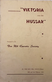
Programme, Box Hill Operatic Society, 'Viktoria and Her Hussar' by Grunwald & Lohner-Benda /, 1958
The Box Hill Operatic Society was founded in 1945 and was sponsored by the Box Hill City Council. Past productions listed on the back page of the programme include The Quaker Girl, High Jinks, A Night Out, The Lilac Domino, Wildflower, Gipsy Love, Katinka, and Maid of the Mountains. Arthur Henry Dear was an employee of the City of Kew, acting as Hall Keeper of the Kew Recreation Hall in Wellington Street, and later the new Kew City Hall in Cotham Road. The Arthur Dear Collection contains memorabilia - tickets, programmes, invitations - as well as his identification badge. Items in the collection dates from the 1940s to the 1960s. The Kew Recreation Hall (Wellington Street) and later the Kew City Hall (Cotham Road) were major locations in suburban Melbourne in the postwar period for civic and private events including theatre productions and exhibitions. The Arthur Dear Collection (in conjunction with the scrapbooks compiled by Marion Tilley) provide a comprehensive snapshot of performing arts in Kew during the 1940s, 1950s and 1960s. The collection includes valuable data about performances, performers, directors etc., during this period. Theatre programme issued by the Box Hill Operatic Society. The 8-page programme contains a title page, a cast list, details of the management, and a brief history of the Company. The performance was held in the Box Hill Town Hall in 1958. arthur dear collection, theatre memorabilia, performing arts - box hill, box hill town hall -
 Kew Historical Society Inc
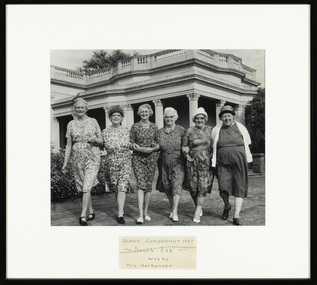
Photograph - Finalists in the 'Queen Competition' at Southesk, Kew Elder Citizens' Club, 1967
The orthodox version of the origins and history of the Kew Elder(ly) Citizens’ Association was established by Cr. W. D. Vaughan in his book Kew’s Civic Century (1960), when he wrote that: "When Mrs. C. H. Simpson was Mayoress in 1952 she set up the Elderly Citizens’ Association to care for the needs of ages persons in Kew. The idea was strongly supported and a start was made by providing social afternoons for elderly folk at Southesk. Visiting sick people in their homes, providing firewood where needed, and other activities were undertaken by the Association. The aid of Council was sought to further the work. It was decided that a social unit for elderly folk be established at Southesk." (p.126-7). In the following pages, he describes in detail Council’s role in formally establishing the Association. This ‘official’ version was reasserted in the later Thematic Environmental History of the City of Boroondara (2012). However the origins and gestation of community of organisations is rarely straightforward. In 1965, five years after Vaughan’s book was published, the author of East Kew Women’s Club : Twenty Years : 20-7-1945-30-7-1965, writing about the period July 1947 to July 1950, described the role the Club played in establishing the Kew Elder Citizens Association. The author wrote: "At a meeting of the Kew Community Aid, the plight of many elderly people in Kew who were dependent on pensions was raised and in order to ascertain their needs the practice was begun of serving morning tea at the Masonic Hall in Walpole Street, where pensions were then paid. From this beginning the Kew Elder Citizens Association was formed in Kew with wide support, and Club members gave willing support on the committee, in helping serve afternoon tea and in entertainment." (p.4) Photographic evidence also leads to questions about Vaughan’s version of events. A framed photograph in the Society’s Collection shows a Public Meeting to form the Kew Elder Citizens Association in a room at Southesk a year earlier in 1951. Whatever version of the origins of the Association is correct, a later framed photograph in the Society’s collection shows the opening of the completed Clubrooms of the Kew Elder Citizens at South Esk by the Hon. E.P. Cameron M.L.C, Minister of Health, on 12 November 1956. The Association is still active in Kew and is currently located at Hamer Court, opposite the Boroondara General (Kew) Cemetery in High Street, Kew.Historic early photograph from the archives of the Kew Elder Citizen's ClubFramed photograph of six women who it is presumed were the candidates or finalists in a competition to be the Queen of Southesk. At this time, Southesk in Cotham Road was home to the Kew Elder Citizens Club, now known as Kew Senior Citizens Centre Inc.Front mount: "Queen Competition 1967 - South Esk - Won by Mrs Harkansee." Reverse: "L-R: -. Miss Knox, Mrs Emmerson, Mrs Higgins, Mrs Moyle, Mrs Harkansee"kew elder citizens club, kew senior citizens centre inc., southesk, miss knox, mrs emmerson, mrs higgins, mrs moyle, mrs harkensee -
 Kew Historical Society Inc
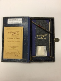
Equipment, The Econasign Co Ltd, The "Econasign" Bijou Super Outfit, 1929-1947
Econasign kits were aimed at small businesses who could use the transparent stencils for the manufacturing of “showcards, price tickets, posters, labels, etc…..by a simple operation of printing by means of transparent stencils.Intact printing kit used in a notable Kew pharmaceutical business.A kit of printing equipment for commercial small display signage. Box and contents produced by the "Econasign" Co. Ltd. 137 Victoria Street, London S.W.1. The box includes a booklet, sample blank paper signs, a brush, and a book of plastic templates. The latter indicates that the kit was distributed by an Australian Agent - J. Raeburn Miller, 8 Bank of NSW Chamber, 280 Castlereagh St., SydneyTyped label on interior: "Donated by the descendants of Charles Gilbert Wood (1891-1948) Pharmacist of 235 High Street, Kew, Vic, / and / Donald Charles Wood (1920-1948) Pharmacist of 283 Doncaster Road, North Balwyn, Vic."econasign, pharmacy printing equipment, charles gilbert wood, donald charles wood -
 Kew Historical Society Inc
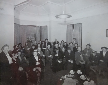
Photograph - Public Meeting to Form Kew Elder Citizens' Club, City of Kew, 1951
The orthodox version of the origins and history of the Kew Elder(ly) Citizens’ Association was established by Cr. W. D. Vaughan in his book Kew’s Civic Century (1960), when he wrote that: "When Mrs. C. H. Simpson was Mayoress in 1952 she set up the Elderly Citizens’ Association to care for the needs of ages persons in Kew. The idea was strongly supported and a start was made by providing social afternoons for elderly folk at Southesk. Visiting sick people in their homes, providing firewood where needed, and other activities were undertaken by the Association. The aid of Council was sought to further the work. It was decided that a social unit for elderly folk be established at Southesk." (p.126-7). In the following pages, he describes in detail Council’s role in formally establishing the Association. This ‘official’ version was reasserted in the later Thematic Environmental History of the City of Boroondara (2012). However the origins and gestation of community of organisations is rarely straightforward. In 1965, five years after Vaughan’s book was published, the author of East Kew Women’s Club : Twenty Years : 20-7-1945-30-7-1965, writing about the period July 1947 to July 1950, described the role the Club played in establishing the Kew Elder Citizens Association. The author wrote: "At a meeting of the Kew Community Aid, the plight of many elderly people in Kew who were dependent on pensions was raised and in order to ascertain their needs the practice was begun of serving morning tea at the Masonic Hall in Walpole Street, where pensions were then paid. From this beginning the Kew Elder Citizens Association was formed in Kew with wide support, and Club members gave willing support on the committee, in helping serve afternoon tea and in entertainment." (p.4) Photographic evidence also leads to questions about Vaughan’s version of events. A framed photograph in the Society’s Collection shows a Public Meeting to form the Kew Elder Citizens Association in a room at Southesk a year earlier in 1951. Whatever version of the origins of the Association is correct, a later framed photograph in the Society’s collection shows the opening of the completed Clubrooms of the Kew Elder Citizens at South Esk by the Hon. E.P. Cameron M.L.C, Minister of Health, on 12 November 1956. The Association is still active in Kew and is currently located at Hamer Court, opposite the Boroondara General (Kew) Cemetery in High Street, Kew.Historic founding photograph of the Kew Senior Citizens AssociationFramed photograph of a meeting at Southesk in Cotham Road to form the Kew Elder Citizens Club. None of the individuals are named. The meeting was not held in the Drawing Room or Ballroom at Southesk as there is an absence of frescoes on the ceiling. The ceiling in the photograph is a cove ceiling however like that in the front two rooms.Handwritten caption: "Public Meeting to Form Kew Elder Citizens, 1951"kew elder citizens club, kew elderly citizens club, kew senior citizens club, southesk -
 Kew Historical Society Inc
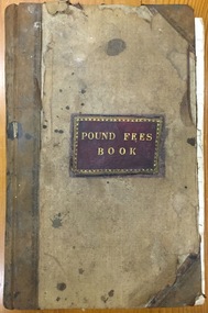
Administrative record (item), Borough of Kew, Pound Fees Book, 1874-1896
... of land bounded by the Kilby Road, Burke Road and High Street... by the Kilby Road, Burke Road and High Street. While the Governor ...While the first successful land sales in Boroondara occurred in Hawthorn in 1843, and Kew in 1845, these areas were to be without local pounds until April 1858, when the Governor of Victoria, in accordance with Act 18 Victoria No 30, was pleased to direct the establishment of a Pound at Glass’s Creek on that part of land bounded by the Kilby Road, Burke Road and High Street. While the Governor was required to proclaim the establishment of a pound, the appointment of a poundkeeper was the responsibility of the Justices of the Peace in the local Court of Petty Sessions. The Pound took its name from the most distinctive natural feature of the area, Glass’s Creek, named after the early pastoralist Thomas Glass.The register is of historic significance as an indicator of suburban life in the second half of the 19th Century. It shows how farming and city life on the urban fringe were intimately connected. It is also significant to the early history of Hawthorn and Kew, who both claimed the Pound following their separation from the Boroondara Roads Board in 1861."Kew Pound Book"glass creek pound (kew), animal pound, dog pound, kew pound, j. smith, john oakes, samuel b. cash, edward s. delaney, emma oswin, samuel cash -
 Kew Historical Society Inc
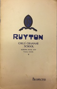
Document, Ruyton Girl's School, Ruyton Girls' Grammar School, Prospectus, 1950
Ruyton was founded in 1878 in the Bulleen Road, Kew, home of newly widowed Mrs Charlotte Anderson (now High Street South). There she hired a governess, Miss Flora Barton, to educate a small group of children, including her own, in her front parlour. Her school immediately flourished. By 1882 she was able to move it to larger premises at ‘Edgecomb’, in Studley Park Road, and name it Ruyton, after a family connection with the village of Ruyton-XI-Towns, Shropshire, England. Since that time Ruyton has continued to thrive, outgrowing its Edgecomb site, and another at A’Beckett Street, Kew, before settling into its current home in Selbourne Road in 1920. The centrepiece of this property is Henty House, now named for its original owners, Henry and Marion Henty, but once known as ‘Tarring’. The grand, polychrome brick home was built in 1872 and with nearly four acres of gardens and grounds around it, it has proved to be a place where Ruyton and its students could continue to prosper. (source: Ruyton website 2020)Prospectus provided in response to an enrolment inquiry in 1950 for Ruyton Girls' Grammar School. (See also Item 2016.0468)ruyton girls grammar school -
 Kew Historical Society Inc
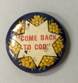
Badge, Come Back to God, 1915-1920
Most of the civic and sporting ephemera assembled by Francis Rigg were patriotic buttons. The use of these buttons as a means of raising revenue through patriotic sentiment occurred soon after Australia pledged allegiance to Empire. Buttons reflected ‘public sentiment, courage, patriotism, generosity and several [un- named] virtues’ such as the martyred mother of a ‘fallen’ hero. Attention was paid to attractiveness of design, encoded symbolism and high quality of production. Expressing ‘loyalty’, they were tokens to be kept for perpetuity. Female labour was used to operate the die that compressed the tin backing, photographic print and celluloid cover together. The pin was applied by hand. Women, of all ages, entered into the spirit of voluntary sales. Often they were sold at the entry and exit points of major pedestrian thoroughfares. The women of Kew set up a kiosk in front of the Post Office and the Railway Station to solicit their round, oval and square shaped wares. Pride in salesmanship was affected by publishing the name of the woman and her fiscal achievement in the major newspapers of the day. The badges form part of a collection of ephemera originally purchased by Francis Horace Rigg (19/10/1882-05/03/1946) of 50 Belford Road, Kew (Vic.). Frances Rigg was a local business identity in Kew, ultimately managing the local branch of the English, Scottish and Australian (ES&A) Bank at 175 High Street, Kew from c. 1920 until the 1940s. After Francis Rigg’s death, the collection of buttons and badges was inherited by his son, Ken Rigg (14/11/1922-19/01/2014). The collection was subsequently donated to the Kew Historical Society in 2015 by his grandson Adrian Rigg during the Gallipoli and Beyond Commemoration.The collection covers a period of almost 40 years. The majority of the badges are patriotic buttons, issued and sold during and immediately after World War 1 to raise funds for national and overseas causes. The collection also includes a number of locally significant sporting event buttons and sporting club medallions, issued in the 1920s and 1930s.The use of common symbols for a range of purposes is sometimes a feature of wartime and post-war fundraising buttons. Like the ‘Hospital Day 1919’ badge, the ‘Come Back to God’ badge is within a seven pointed star on a dark blue ground with sprays of wattle; attempting to harness nationalism with religion.Come back to Godbutton -
 Kew Historical Society Inc
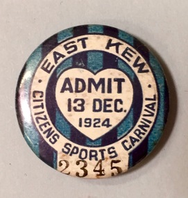
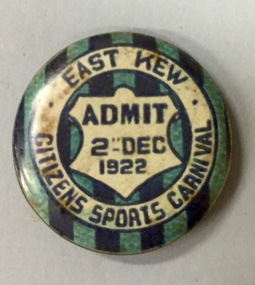
Badge - Fundraising Button, East Kew Citizens Sports Carnival: Admit 13 Dec. 1924, 1924
Most of the ephemera assembled by Francis Rigg were patriotic buttons but also included come sporting event buttons including two associated with the East Kew Citizens Sports Carnival. The subdivision of the area now known as Kew East commenced before World War 1, but it was not until the 1920s that it became fully developed. At this time, there was a strong Progress Association and this body raised funds to purchase land and build the East Kew Citizen’s Hall in Normandy Road, the first stage of which was completed in 1922. This hall was designed to be extended, although this never occurred, and the building now forms part of the facilities of the East Kew Uniting Church. The ‘East Kew Citizens Sports Carnival’ may well have been a fundraiser event for the building fund. As far as is known, the carnival was only held for a couple of years.Frances Rigg was a local business identity in Kew, at one stage managing the local branch of the English, Scottish and Australian (ES&A) Bank at 175 High Street from c. 1920 until the 1940s. After Francis Rigg’s death, the collection of buttons and medallions was inherited by his son, Ken Rigg (1922-2014). The collection was subsequently donated to the Kew Historical Society in 2015 by Francis' grandson, Adrian Rigg, at the time of the Gallipoli & Beyond Commemoration in 2015. The collection covers a period of almost 40 years. The majority of the buttons are patriotic buttons, issued and sold during and immediately after the First World World War (1914-1918) to raise funds for national and overseas causes. The collection also includes a number of locally significant sporting event buttons and sporting club medallions, issued in the 1920s and 1930s.A circular badge produced for the East Kew Citizens Sports Carnival in 1924. The badge has a ground of vertical stripes in shades of blue. The name of the event is within a white circular band. A white shield in the centre includes the words “Admit” which would indicate that the badge was purchased and worn on the day of the carnival to indicate that the wearer had paid the admission fee."East Kew Citizens Sports Carnival / Admit 13 Dec. 1924"kew east, sport buttons -
 Kew Historical Society Inc
Badge - Fundraising Button, East Kew Citizens Sports Carnival, Admit 2nd December 1922, 1922
Most of the ephemera assembled by Francis Rigg were patriotic buttons but also included come sporting event buttons including two associated with the East Kew Citizens Sports Carnival. The subdivision of the area now known as Kew East commenced before World War 1, but it was not until the 1920s that it became fully developed. At this time, there was a strong Progress Association and this body raised funds to purchase land and build the East Kew Citizen’s Hall in Normandy Road, the first stage of which was completed in 1922. This hall was designed to be extended, although this never occurred, and the building now forms part of the facilities of the East Kew Uniting Church. The ‘East Kew Citizens Sports Carnival’ may well have been a fundraiser event for the building fund. As far as is known, the carnival was only held for a couple of years.Frances Rigg was a local business identity in Kew, at one stage managing the local branch of the English, Scottish and Australian (ES&A) Bank at 175 High Street from c. 1920 until the 1940s. After Francis Rigg’s death, the collection of buttons and medallions was inherited by his son, Ken Rigg (1922-2014). The collection was subsequently donated to the Kew Historical Society in 2015 by Francis' grandson, Adrian Rigg, at the time of the Gallipoli & Beyond Commemoration in 2015. The collection covers a period of almost 40 years. The majority of the buttons are patriotic buttons, issued and sold during and immediately after the First World World War (1914-1918) to raise funds for national and overseas causes. The collection also includes a number of locally significant sporting event buttons and sporting club medallions, issued in the 1920s and 1930s.A circular button produced for the East Kew Citizens Sports Carnival in 1922. The button has a ground of vertical stripes in shades of blue. The name of the event is within a white circular band. A white shield in the centre that includes the words “Admit” would indicate that the badge was purchased and worn on the day of the carnival to indicate that the wearer had paid the admission fee. "East Kew Citizens Sports Carnival, Admit 2nd December 1922"east kew, east kew citizens sports carnival, sports, badge, numismatics, francis rigg -
 Kew Historical Society Inc
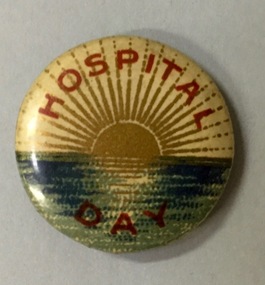
Badge - Fundraising Button, Hospital Day, 1914-1918
Most of the civic and sporting ephemera assembled by Francis Rigg were patriotic buttons. The use of these buttons as a means of raising revenue through patriotic sentiment occurred soon after Australia pledged allegiance to Empire. Buttons reflected ‘public sentiment, courage, patriotism, generosity and several [un- named] virtues’ such as the martyred mother of a ‘fallen’ hero. Attention was paid to attractiveness of design, encoded symbolism and high quality of production. Expressing ‘loyalty’, they were tokens to be kept for perpetuity. Female labour was used to operate the die that compressed the tin backing, photographic print and celluloid cover together. The pin was applied by hand. Women, of all ages, entered into the spirit of voluntary sales. Often they were sold at the entry and exit points of major pedestrian thoroughfares. The women of Kew set up a kiosk in front of the Post Office and the Railway Station to solicit their round, oval and square shaped wares. Pride in salesmanship was affected by publishing the name of the woman and her fiscal achievement in the major newspapers of the day. The button forms part of a collection of ephemera originally purchased by Francis Horace Rigg (19/10/1882-05/03/1946) of 50 Belford Road, Kew (Vic.). Frances Rigg was a local business identity in Kew, ultimately managing the local branch of the English, Scottish and Australian (ES&A) Bank at 175 High Street, Kew from c. 1920 until the 1940s. After Francis Rigg’s death, the collection of buttons and badges was inherited by his son, Ken Rigg (14/11/1922-19/01/2014). The collection was subsequently donated to the Kew Historical Society in 2015 by his grandson Adrian Rigg during the Gallipoli and Beyond Commemoration. The collection covers a period of almost 40 years. The majority of the badges are patriotic buttons, issued and sold during and immediately after World War 1 to raise funds for national and overseas causes. The collection also includes a number of locally significant sporting event buttons and sporting club medallions, issued in the 1920s and 1930s.Round metal button in red, white, blue and gold showing a sun setting over the sea with words printed in red around border and on lower outer rim.hospital day, patriotic buttons, first world war (1914-18) -
 Kew Historical Society Inc
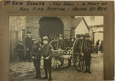
Photograph, 1st Kew Scouts Fire Drill, 1911, 1911
A Volunteer Fire Brigade was established in Kew in 1879 and a fire station established in Walton Street, Kew. The Brigade was formally disbanded by the Fire Brigade Act of 1890 and the volunteers replaced by a unit of the Metropolitan Fire Brigade in 1891. The building shown in this rare photograph was constructed in 1893. In the background can be seen a house on the corner of Walton and Peel Streets, one of two, built in 1893 for firemen of the Brigade. An article in The Weekly Times (1 April 1911) records that: "Kew Troop - A,S.M. Williams reports:- The troop under S.M. Kellett. marched to the Kew Fire Brigade station, to receive instruction in fire drill from Mr Gross, the officer in charge, but as he was unexpectedly called away, the S.M. S and A.S.M had to instruct the Troop. Every boy was taught how to sink the hydrant, and how to couple and uncouple the hose. The hose reel was then brought into action, and the boys were divided into sets of six, each division taking its turn in pulling the reel up a hill to the water plug, where the hydrant was quickly sunk by one Scout, two more uncoupling the hose and coupling it on to the hydrant. We have gained four recruits during the last week, and are expecting two more next week."This is a fine, original photograph, probably taken by a commercial photographer, showing the 1st Kew Scouts in front of the old Kew Fire Brigade building in Walton Street in 1911. The building, constructed in 1893 was later demolished in 1941. This is a rare historic photograph of the Station. Unfortunately the name of the photographer is unrecorded.1st Kew Scouts undertaking a fire drill in front of the old Kew Fire Station in Walton Street, Kew. The reverse details the names and addresses of the Scouts featured in the photograph. An integral part of the Scout program is service to others and working with the fire brigade would have been just one of many such training activities enthusiastically undertaken by the Scouts. The Kew Fire Brigade had hand-drawn fire appliances up until 1919 when a motorised vehicle was purchased. The fire station was replaced by the Belford Road station in 1941 and subsequently demolished. Front: "First Kew Scouts - Fire Drill - In front of Kew Fire Station - Walton St. Kew" Reverse: "Walton St Kew / Kew Fire Station / Mr Gross o/c Fire Station / Bert Gundy Clark, part-time fireman / Allan Sewell Gellibrand St. / Clappy Williams Hawthorn ? / Allan Barrett Cobden St / Allan Woollard High St"kew fire brigade - walton street, scout groups --- kew (vic), 1st kew boy scouts -
 Kew Historical Society Inc
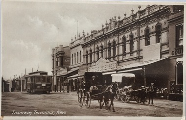
Postcard, Oastler (Leading Stationer), Tramway Terminus, Kew, c.1913
... Cotham Road -- high street --- kew (vic.).... postcards -- kew (vic.) trams -- kew (vic.) Cotham Road -- high ...The Kew Historical Society's postcard collection includes views of Kew, Melbourne and Greater Melbourne as well as those including overseas scenes sent or received from Europe or the Middle East. They date from the 1890s to the 2000s. These postcards may or may not include the name of the publisher or printer. A number of the cards were published as parts of popular series. A way of dating early postcards is to identify whether the reverse was divided by a central line which became the norm after 1902 in the United Kingdom. However, other postcards produced after this date do not always conform to this print layout.A monochrome postcard of the tram terminus beside 'The Block' in Cotham Road, KewOastler, leading stationer, Kew / Printed in Saxonypostcards -- kew (vic.), trams -- kew (vic.), cotham road -- high street --- kew (vic.), the block -- cotham road -- kew (vic.) -
 Kew Historical Society Inc
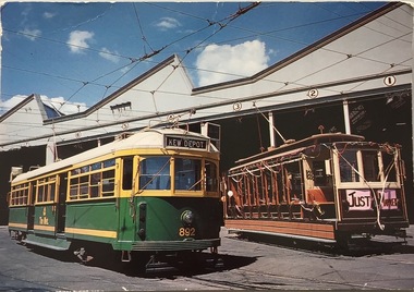
Postcard, Biscay Greetings Pty Ltd, Trams at Kew Depot, c.1991
... and High Street, Kew. It is one of eight tram depots... and High Street, Kew. It is one of eight tram depots ...The Kew tram depot is located on the corner of Barkers Road and High Street, Kew. It is one of eight tram depots on the Melbourne tram network. The depot opened on 8 May 1915. The main yard has 12 covered roads. There are two tracks for trams leaving or entering via Barkers Road, and a single track connecting to High Street.Postcard produced c.1991 to commemorate 75 Years of Service of The Kew Depot (1915/16-1991). The postcard shows two trams at the depot. The details are included in the information provided on the reverse.Kew Depot is ready for work W Class 892 waits for its next duty while visiting V Class 214 is ready for special work Photo by R. J. Marsh T101 Copyright Biscay Greetings Pty Ltd Telephone (03) 562 3599tramways - kew, kew tramways depot, -
 Kew Historical Society Inc
Plan, Melbourne & Metropolitan Board of Works : Borough of Kew : Detail Plan No.1296, 1904
The Melbourne and Metropolitan Board of Works (MMBW) plans were produced from the 1890s to the 1950s. They were crucial to the design and development of Melbourne's sewerage and drainage system. The plans, at a scale of 40 feet to 1 inch (1:480), provide a detailed historical record of Melbourne streetscapes and environmental features. Each plan covers one or two street blocks (roughly six streets), showing details of buildings, including garden layouts and ownership boundaries, and features such as laneways, drains, bridges, parks, municipal boundaries and other prominent landmarks as they existed at the time each plan was produced. (Source: State Library of Victoria)This plan forms part of a large group of MMBW plans and maps that was donated to the Society by the Mr Poulter, City Engineer of the City of Kew in 1989. Within this collection, thirty-five hand-coloured plans, backed with linen, are of statewide significance as they include annotations that provide details of construction materials used in buildings in the first decade of the 20th century as well as additional information about land ownership and usage. The copies in the Public Record Office Victoria and the State Library of Victoria are monochrome versions which do not denote building materials so that the maps in this collection are invaluable and unique tools for researchers and heritage consultants. A number of the plans are not held in the collection of the State Library of Victoria so they have the additional attribute of rarity.Original survey plan, issued by the MMBW to a contractor with responsibility for constructing sewers in the area identified on the plan within the Borough of Kew. The plan was at some stage hand-coloured, possibly by the contractor, but more likely by officers working in the Engineering Department of the Borough and later Town, then City of Kew. The hand-coloured sections of buildings on the plan were used to denote masonry or brick constructions (pink), weatherboard constructions (yellow), and public buildings (grey). This area was once known as O’Shaughnessy’s Paddock. O’Shaughnessy was the licensee of the Kew Hotel. The ‘Paddock’ or farm was for many years the closest farm to Melbourne. By 1903, when this plan was surveyed and lithographed, little of the farm remained. The area is dominated by a ‘clay hole’, on the site of the current Foley Reserve. It was used by Smart’s Brickyard from the 1880s until 1911, when the Council purchased it for a rubbish dump. It is notable as the site is one of the few industrial operations to have existed in Kew. By 1903, urban development was characterised by larger houses fronting Barkers Road and brick and weatherboard villas in Foley Street. Nearer the pit, weatherboard houses predominated. Foley Street bisected the triangular block and continued right to Denmark Street. At this stage, a house impeded the through road, only allowing access via a right of way to High Street.melbourne and metropolitan board of works, detail plans, mmbw 1296, cartography -
 Kew Historical Society Inc
Plan, Melbourne & Metropolitan Board of Works : Borough of Kew : Detail Plan No.1573, 1905
The Melbourne and Metropolitan Board of Works (MMBW) plans were produced from the 1890s to the 1950s. They were crucial to the design and development of Melbourne's sewerage and drainage system. The plans, at a scale of 40 feet to 1 inch (1:480), provide a detailed historical record of Melbourne streetscapes and environmental features. Each plan covers one or two street blocks (roughly six streets), showing details of buildings, including garden layouts and ownership boundaries, and features such as laneways, drains, bridges, parks, municipal boundaries and other prominent landmarks as they existed at the time each plan was produced. (Source: State Library of Victoria)This plan forms part of a large group of MMBW plans and maps that was donated to the Society by the Mr Poulter, City Engineer of the City of Kew in 1989. Within this collection, thirty-five hand-coloured plans, backed with linen, are of statewide significance as they include annotations that provide details of construction materials used in buildings in the first decade of the 20th century as well as additional information about land ownership and usage. The copies in the Public Record Office Victoria and the State Library of Victoria are monochrome versions which do not denote building materials so that the maps in this collection are invaluable and unique tools for researchers and heritage consultants. A number of the plans are not held in the collection of the State Library of Victoria so they have the additional attribute of rarity.Original survey plan, issued by the MMBW to a contractor with responsibility for constructing sewers in the area identified on the plan within the Borough of Kew. The plan was at some stage hand-coloured, possibly by the contractor, but more likely by officers working in the Engineering Department of the Borough and later Town, then City of Kew. The hand-coloured sections of buildings on the plan were used to denote masonry or brick constructions (pink), weatherboard constructions (yellow), and public buildings (grey). This plan has detailed annotations written in red or blue ink, showing prices, which may be the annual valuations of the properties, and some owners’ names, a most unusual feature on contractor's maps. Some areas, such as the buildings of Methodist Ladies’ College (MLC), include the school’s tennis court and swimming pool, but are not coloured to show building materials – did the draftsman just run out of time, or ink, or enthusiasm, before his plan had to be submitted? MLC had been founded in 1882 as a ‘modern school of the first order’ with buildings that formed ‘a collegiate institution for girls unsurpassed in the colonies’. The goal of its founders was to provide a high-class Christian education for girls, comparable with that provided elsewhere for boys. Some shops are shown along Edgevale Road, though they are not designated as commercial premises. Larger houses are depicted, including ‘Fairlawn’ in Barkers Road, and ‘Clevedon’ and ‘Rosehill’ (now demolished) in Fitzwilliam Street.melbourne and metropolitan board of works, detail plans, mmbw 1573, maps - borough of kew, cartography