Showing 123820 items matching "main-road"
-
 Wodonga & District Historical Society Inc
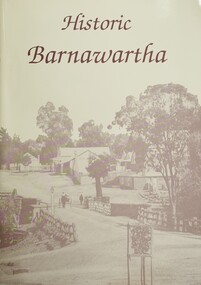
Book - Historic Barnawartha, Barnawartha History Book Committee, 1992
This publication was created by a local history group at Barnawartha, Victoria to update an earlier publication and document the local history of their community. It includes information about early homesteads, the Barnawartha Primary School and other community institutions. An 1899 map of the parish of Barnawartha is included.A4 sized publication of 70 pages, including maps and illustrations. Beige coloured cover features an image of the main street of Barnawartha township prior to 1900.non-fictionThis publication was created by a local history group at Barnawartha, Victoria to update an earlier publication and document the local history of their community. It includes information about early homesteads, the Barnawartha Primary School and other community institutions. An 1899 map of the parish of Barnawartha is included.barnawartha, barnawartha primary school -
 National Vietnam Veterans Museum (NVVM)
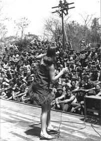
Photograph, Gibbons, Denis, Hey Yokomo
Denis Gibbons (1937 – 2011) Trained with the Australian Army, before travelling to Vietnam in January 1966, Denis stayed with the 1st Australian Task Force in Nui Dat working as a photographer. For almost five years Gibbons toured with nine Australian infantry battalions, posting compelling war images from within many combat zones before being flown out in late November 1970 after sustaining injuries. The images held within the National Vietnam Veterans Museum make up the Gibbons Collection. A black and white photograph - Dinah Lee has the main body of the diggers enthralled with her presentation of 'Hey Yokomo' at 1st ATF Base Nui Dat.photograph, nui dat, 1st atf base, dinah lee, entertainer, gibbons collection catalogue, diggers, denis gibbons -
 Lakes Entrance Historical Society
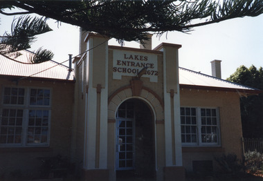
Photograph - Lakes Entrance Primary School, 1999
Colour photograph showing unusual main entry of archway between two concrete pillars of the Lakes Entrance Primary School No.2672. Lakes Entrance Victoriaschools, buildings -
 University of Melbourne, Burnley Campus Archives
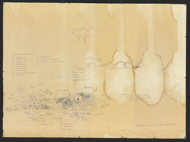
Plan, Border Next to Staff Car Park, c. 1980
(1) Rough hand drawn plan in pencil and biro of area between pergola and roadway to Library opposite Roundabout Lawn. (2) Photocopy of main portion.pergola, library, burnley horticultural college, border garden, driveway -
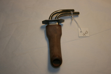 Geoffrey Kaye Museum of Anaesthetic History
Equipment - Airway, Pharyngeal, Brown's, 1920
Metal tube with a flat plate across the top with two additional metal tubes coming out of it and curved toward the right. The main tube is covered in rubber.airway, insufflation, gilbert brown, pharyngeal -
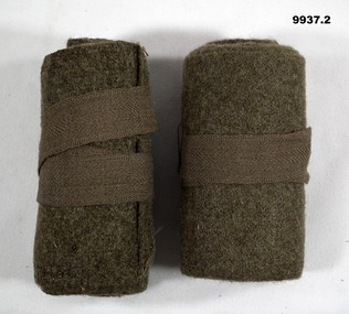 Bendigo Military Museum
Uniform - PUTTEES, LEG WRAPPINGS
Puttees used as ankle support and protection from debris entering boots or pants. Part of the collection of "John Young". Refer Cat No. 1181.3 for service details.Army Green Puttees. Main strap of material is 102 cm long with an additional tie 48 cm long. Both puttees rolled up and tied.Imprinted on one end in white - hard to read. "9018A" - on one only. "FOX?" - on both. "1965" - on both.john young collection, puttees, uniform -
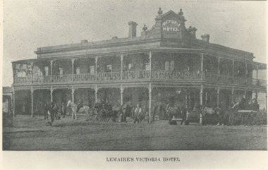 Lakes Entrance Historical Society
Photograph - Lemaires Victoria Hotel Bairnsdale Victoria, 1900 c
Designed by AF Kramer contractor Jonadab Townsend. Built on site of former Mitchell Hotel destroyed by fire 1885 First licensee of Victoria Hotel J A PatersonBlack and white photograph of Lemaires Victoria Hotel with small crowd of people horses and horse drawn vehicles out the front Main Street Bairnsdale Victoriabuildings, hotels -
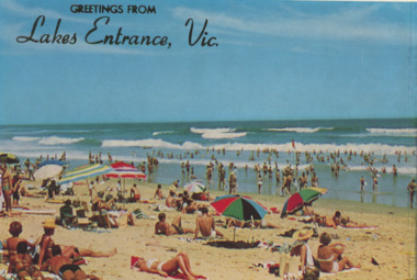 Lakes Entrance Historical Society
Postcard - Tourism, Rose Stereograph Co, 1960c
Colour postcard of crowd of people many in bathing costumes or sheltered under sun umbrella enjoying sand and surf at Main Beach Lakes Entrance VictoriaGreetings from Lakes Entrance Vic.tourism, waterways, beaches -
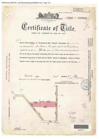 Ringwood and District Historical Society
Document, Certificate of Title - Harold Claude Howship, Nurseryman, Ringwood, Vic. - 1928
A4 copies of Landata Victoria Historical Search documents - Vol 5485 Fol 1096804. Harold Claude Howship of Mt. Dandenong Road Ringwood, Nurseryman, is now the proprietor of an Estate in Fee-simple subject to the Encumbrances notified hereunder ... 5 acres 3 roods 10 perches or thereabouts, part of Crown Section Twenty, Parish of Warrandyte, County of Evelyn, together with a right of carriage way over roads coloured brown. Subdivision map includes Wonga Road (later Warranwood Road), Grandview Grove (later Bemboka Road), and Plymouth Road, Ringwood. Proprietors and Transfers include Emily Mills, Plymouth Road Ringwood, Widow - 27th January, 1939. William George Carter, Grandview Grove Warranwod - 14th March, 1947 - 3 acres Evelyn Goudie and Beverley Gwen Goudie, Wonga Road Warranwood - 23rd October, 1950 - 1 acre -
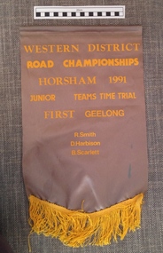 Geelong Cycling Club
Banner, 1991
This banner is one of the many awarded in the Western District of Victoria for competitive cycling races. The Western District Road Racing competitions were significant in being a regional competition which the Geelong Cycling Club took part in.Grey coloured satin cloth banner. The banner has a yellow fringe attached to the bottom of it and has yellow embossed inscriptions. "Western District Road Road Championships/Horsham 1991/Junior Teams Time Trial/First Geelong/R. Smith/D. Harbison/B. Scarlett"western district road racing; geelong cycling club; horsham; junior teams time trial; r. smith; d. harbison; b. scarlett; banner; -
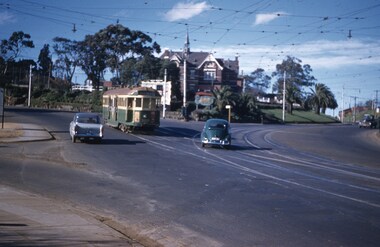
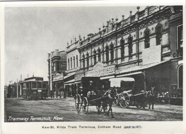 Kew Historical Society Inc
Postcard, Tramway Terminus, Kew, 1913
This work forms part of the collection assembled by the historian Dorothy Rogers, that was donated to the Kew Historical Society by her son John Rogers in 2015. The manuscripts, photographs, maps, and documents were sourced by her from both family and local collections or produced as references for her print publications. Many were directly used by Rogers in writing ‘Lovely Old Homes of Kew’ (1961) and 'A History of Kew' (1973), or the numerous articles on local history that she produced for suburban newspapers. Most of the photographs in the collection include detailed annotations in her hand. The Rogers Collection provides a comprehensive insight into the working habits of a historian in the 1960s and 1970s. Together it forms the largest privately-donated collection within the archives of the Kew Historical Society.A copy of a book plate in Vaughan in 'Kew's Civic Century' (1960) which was itself a copy of a postcard from circa 1913."tram about 1913. Terminus, Cotham Road. Tramway Terminus, Kew. Kew-St Kilda Tram Terminus, Cotham Road (see p.47)"cotham road (kew), dorothy rogers, postcards - kew (vic.) -
 National Wool Museum
Photograph - Mt Kenya, J W Allen, 1928-1929
This photograph was found loose in the first of three albums compiled and owned by J W Allen, Secretary of New South Wales Grazier's, and is associated with the New South Wales Graziers Association world tour of sheep 1928-1929. The album contains photographs of travel, sheep, farms, stations, people and landscapes from around the world. Locations include Naples, Port Said, Suez, Birregurra (Vic), Alexandra (Vic), Ballangeich (Vic), Keith (SA), Mt Gambier (SA), Buckland Park (SA), Tasmania, Winton (QLD), Sydney Harbour, Canberra (ACT), Toowoomba (QLD), Rockhampton (QLD), Tocal (NSW), Deepwater (NSW), Glen Innes (NSW), Longreach (QLD), Moree (NSW), Barraba (NSW) and Mudgee (NSW). Properties depicted include Mooleric, Turkeith, Woolongoon, Minadale, Crower Station, Merrindie, Koomooloo Station, Cappeedee, Koonoona, Rathmore, Ellenthorpe, Camden Park Station, Glenlegh, Strathmore Station, Ilparran Station, Binneguy, Midkin, Terlings, Ashley, Bereen, Plumthorpe, Mayvale and Havilah. The album was found in a clean out at the Great Southern Agricultural Research Institute and donated to the National Wool Museum, along with other related material such as photographs, glass lantern slides and ephemera.Black and white photograph depicting a landscape with bushland. back: [handwritten] Mt. Kenya / from Narrmore – Nanyuki / Road / Naromore – Nanyuki Road / Piece of bush belt with [?] Mt. Kenya / behind / [printed] Veloxagriculture, sheep, farming, stations, research, breeding, photography, travel -
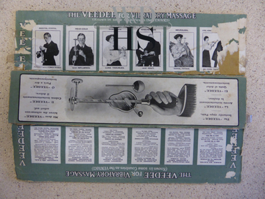 Warrnambool and District Historical Society Inc.
Packaging, Box, Early 20th century
The box pieces belong to a VeeDee Massager that has been in the Historical Society collection for several years. It is an interesting example of the dubious medical aids used by 19th century and early 20th century people who resorted to this sort of appliance to try to find relief for many ailments. The box lists the ailments that the massager claims to be able to treat effectively. These include rheumatism, lung troubles, sciatica, insomnia, kidney disease, paralysis, constipation, deafness, bowel complaints and tumours. These box pieces are kept because they have much information on them regarding the use of the VeeDee massager, with a list of the ailments and medical conditions that are claimed to be cured or aided by the use of massager. The information is of use when researching social and medical history and tells us much about the primitive knowledge of ailments and illnesses in the 19th and early 20th centuries. The massager is a medical curiosity of much interest to people today and is a valuable and fascinating display piece. These are the remains of a box that contained a VeeDee massager. There are two pieces - a flattened piece of cardboard that once formed the base and sides of the box and another cardboard piece that was the top of the box. The two small ends of the original box are missing. The inside of the box is red and the base and the sides are green and white with illustrations and descriptive material in black printingThe box pieces have much printed material on them in six languages, but the main heading is ‘THE VEEDEE FOR VIBRATORY MASSAGE’warrnambool, allied health -
 National Wool Museum
Photograph - A Queensland Town, J W Allen, 1928-1929
This photograph was found loose in the first of three albums compiled and owned by J W Allen, Secretary of New South Wales Grazier's, and is associated with the New South Wales Graziers Association world tour of sheep 1928-1929. The album contains photographs of travel, sheep, farms, stations, people and landscapes from around the world. Locations include Naples, Port Said, Suez, Birregurra (Vic), Alexandra (Vic), Ballangeich (Vic), Keith (SA), Mt Gambier (SA), Buckland Park (SA), Tasmania, Winton (QLD), Sydney Harbour, Canberra (ACT), Toowoomba (QLD), Rockhampton (QLD), Tocal (NSW), Deepwater (NSW), Glen Innes (NSW), Longreach (QLD), Moree (NSW), Barraba (NSW) and Mudgee (NSW). Properties depicted include Mooleric, Turkeith, Woolongoon, Minadale, Crower Station, Merrindie, Koomooloo Station, Cappeedee, Koonoona, Rathmore, Ellenthorpe, Camden Park Station, Glenlegh, Strathmore Station, Ilparran Station, Binneguy, Midkin, Terlings, Ashley, Bereen, Plumthorpe, Mayvale and Havilah. The album was found in a clean out at the Great Southern Agricultural Research Institute and donated to the National Wool Museum, along with other related material such as photographs, glass lantern slides and ephemera.Black and white photograph showing a row of buildings, with a fence in the foreground and trees in the background. back: [handwritten] B / A Queensland town – main street / from train. / Note houses on [?} – white ants / & cooleragriculture, sheep, farming, stations, research, breeding, photography, travel -
 Bendigo Military Museum
Photograph - POSTCARD, PHOTOGRAPHIC, WW1, C.1915
This card was written by Cyril James Claridge McQuie MM & Bar to his Mother. The letter talks about finishing at Seymour camp and his mates (in the photo) are being separated. McQuie thinks he will sail about the 16th. The names on the photo are hard to read but appear to be, Stokes, Hopkins, Hofferman, Sash ?, Keneilly ?, Rayson, Han......, Muller ?, Bearlip ?. McQuie is centre of the sitting, kneeling group. McQuie enlisted No 2654 on 26.6.1915 in the 8th Reinforcements 6th Bn age 23 years 6 months. Embarked for Eygpt 26.8.1915, embarked for ANZAC (Gallipoli) 31.10.1915, embark for Eygpt 2.12.1915, Hospital 5.12.1915 with Boils, rejoin unit 7.1.1916, promoted to Cpl 13.3.1916, embark for France 26.3.1916, promoted to Sgt 2.9.1916, Posted to Pay Corps Etaples 13.1.1917, rejoin unit 25.6.1917, hospital GSW Left Arm 20.9.1917, awarded the Military Medal same day, rejoin unit 21.12.1917, awarded a Bar to the Military Medal 10.8.1918, WIA 2nd occasion Gassed, promoted to 2nd Lieutenant, discharged from the AIF 11.2.1920. A brother Alick Charles Hebdon McQuie No 2158 enlisted on 14.4.1915 in 6th Reinforcements 7th Bn, embarked for Eygpt 17.6.1915, KIA 9.8.1915. McQuie appears to have been a great collector of Postcards which will be shown throughout the collection.Photo B& W showing 6 soldiers standing and 5 sitting or kneeling, in the background are white tents. The rear has extensive text in black pen with a red stamp top RH corner.Main points are, "YMCA Depot Camp Seymour", "dear Mother", "J.P.B. McQuie Thirlstane Harrison Street Bendigo"postcard, seymour -
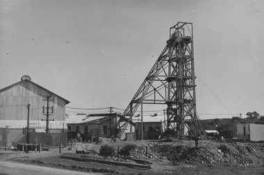 Bendigo Historical Society Inc.
Photograph - Nell Gwynne Headframe, 1936
Significant to mining history of Bendigo.Black and white photograph: Nell Gwynne headframe, erection completed. Mine sheds in background, power poles on left hand side. Ladder on side of headframe, giving access to first platform on headframe.Written in pencil on back of photograph : '.Nell Gwynne main shaft headframe being painted 3/5/35 ''nell gwynne gold mine, bendigo, gold mining, main shaft, paint -
 Bendigo Historical Society Inc.
Photograph - Nell Gwynne Main Shaft, 1934
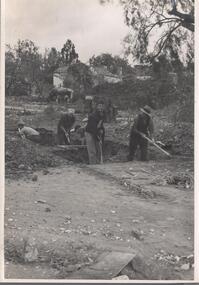
Significant to mining history of Bendigo.Black and white photograph of five men standing on surface starting to dig a mine shaft. One man is wearing a jumper with 'CFC" (Carlton Football Club ?) on front. String lines are set out to define the boundary of the shaft. In background, weatherboard house depicted in (11032.11 and 11032.12), and a cow standing alongside house. Written in pencil on back of photograph in black pen: 'Nell Gwynne main shaft starting 26/9/34'nell gwynne gold mine, shaft -
 Kew Historical Society Inc
Plan - Subdivision Plan, Corsewall Estate, Hawthorn, 1938
The Kew Historical Society collection includes almost 100 subdivision plans pertaining to suburbs of the City of Melbourne. Most of these are of Kew, Kew East or Studley Park, although a smaller number are plans of Camberwell, Deepdene, Balwyn and Hawthorn. It is believed that the majority of the plans were gifted to the Society by persons connected with the real estate firm - J. R. Mathers and McMillan, 136 Cotham Road, Kew. The Plans in the collection are rarely in pristine form, being working plans on which the agent would write notes and record lots sold and the prices of these. The subdivision plans are historically significant examples of the growth of urban Melbourne from the beginning of the 20th Century up until the 1980s. A number of the plans are double-sided and often include a photograph on the reverse. A number of the latter are by noted photographers such as J.E. Barnes.This is a second, more complete version of the Corsewall Estate subdivision that is held by the Society. The Coreswall Estate was a subdivision, bordering on Barkers Road and Auburn Road, which created Corsewall Close. This relatively late subdivision included 29 allotments. The subdivision plan includes the dimensions of each lot as well as the width of the existing and projected roads and turning circles. The Corsewall Close Precinct is now listed on the Victorian Heritage Database (HO147) and is noted for its ‘consistent flat-type development over the entire street, which has been cleverly designed to make multi-unit dwellings appear as single buildings’. In this second version of the plan, the rarity of this late subdivision is emphasised by the auctioneers. The original plan must have contained a photograph, which is unfortunately truncated here.subdivision plans - hawthorn, corsewall estate -
 Kiewa Valley Historical Society
Souvenir Postcard Folder – Falls Creek Ski Village
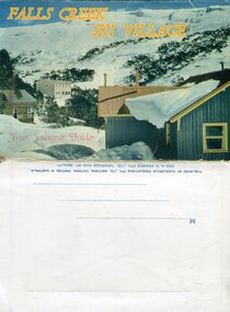
After World War II, the Kiewa Hydroelectric Scheme was started in the Kiewa River valley by the State Electricity Commission of Victoria. On land previously used only for summer cattle grazing in the natural alpine grasslands, the first ski lodge was built in 1948 by workers from the scheme. The first lift, a rope tow, was built in 1951 and the first chairlift in Australia was constructed there in 1957. Falls Creek Post Office opened on 9 June 1958 (with telegraph and telephone facilities only until 1964) .Despite strong opposition from the head of the Kiewa scheme, who didn't want tourists clogging up his roads and destroying his "dry" construction camps by bringing in booze, Falls Creek boomed as much as Hotham, partly owing to its relatively good access road. Early lodges included Bogong (c.1946), Skyline (1947), Albury (1949), Myrtleford (1949) and Dawn (c.1950).The souvenir postcard photographed and produced by an enterprising local businessman Mr S K Pearce, was produced as a memento for skiers and other visitors to the Falls Creek and Mt Beauty area to send to family and friends as a reminder of their visit to the region, or to keep as a personal souvenir. It presented an excellent promotional opportunity for enterprising local businessmen to promote the area to skiers and tourists near and far. It also presents an excellent pictorial history of the falls creek area around the late 1950’s to early 1960’sColour postcard folder (unused) containing 13 photographs of the Falls Creek ski area and surrounds. Inside cover has a brief description of the area and the services available to visitors Printed on front cover- FALLS CREEK SKI VILLAGE. Your Souvenir Folder Photo of skiing slopes of the village Inside front flap - a brief description of the Falls Creek area and the services available to visitors 1. Diana Lodge parking area and Spion Kopje 2. Winterhaven Lodge 3. Ski Hirage Centre and skiing slopes 4. Ski Lodges from main road 5. Nelse and Arundel Lodges 6. Day visitors’ shelter and parking area 7. Summit T-Bar lift 8. Spur T-bar looking towards Village and Spion Kopje 9. T-bar lower station and Snow Crystal Inn 10. ‘Akja’ rescue sled in use 11. Falls Creek road and Grand Coeur Lodge annex 12. Rope tows and beginner slopes 13. Back cover- Published by Nucolorvue Pty Ltd Mentone Vic. Printed in Australia For S.K.Pearce Pty Ltd Tawonga and Mt Beauty falls creek, snow, bogong high plains, victorian alps -
 Whitehorse Historical Society Inc.
Photograph, Mitcham & Brunswick Roads, 2000
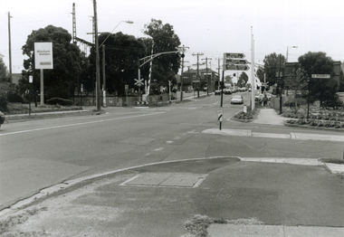
Produced as one of a series of 24 prints commissioned by Nunawading & District Historical Society -|Theme: Intersections of Mitcham and Nunawading 2000/2001.|See also Series by P. Simmenauer on the same theme.Black and white photograph - print and negative of Corner of Mitcham Road and Brunswick Road, Mitcham, looking North towards Railway Crossing. From left-right: Rail Station sign - 'Mitcham/Station/Connex'. On near side corner of Brunswick Road signage for: Mitcham Angling Club; Mitcham Community Centre; Mitcham Senior Citizens Club; Street sign: Brunswick Road.mitcham railway station, connex, mitcham angling club, angler's club, mitcham community house, mitcham senior citizens club, brunswick road, mitcham, mitcham road -
 Falls Creek Historical Society
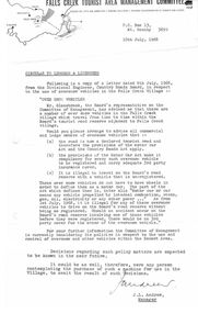
Document - Circular - Use Of Oversnow Vehicles From Divisional Engineer
Bob (Herman) Hymans (a former member of the Royal Netherlands Navy) was born in Bloemendaal, Holland on 30th September 1922. During World War II he fought against the Japanese in the Dutch East Indies (now Indonesia) and was imprisoned in Changi and on the Burma Railway. After gaining qualifications as a Ski Instructor, Bob arrived in Falls Creek in July 1950. Working as an Instructor and Supervisor at Bogong Lodge, Bob decided his future was in accommodation. He was successful in negotiating an indenture for land from the State Electricity Commission (SEC). It took Bob two years to build his Grand Coeur Chalet but, tragically, it was burned down in August 1961. Bob also built the first Chairlift in Australia. This was a single chairlift and the structure was built from wooden electricity poles. He was constantly full of new ideas and proposals for the village. Bob Hymans died on 7th July 2007. This Collection of documents and letters tells the story of Bob's endeavours to develop Falls Creek into the ski village it is today.This item is significant because it documents actions taken by the Falls Creek Tourist Area Management Committee in their role overseeing the Tourist Area.A circular from the Management Committee relaying information from the Country Roads Board related to the use of vehicles in the Falls Creek Village Area. The road adjacent to the Falls Creek Tourist Village is now a declared road, so only registered vehicles can now use that road. If not registered, vehicles and their owners would not be covered by 3rd party insurance in the event of an accident.falls creek tourist area management committee, falls creek administration, bob hymans -
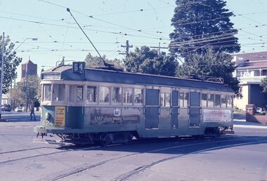
 Melbourne Tram Museum
Slide - Set of 2, John Webster, 14/06/1960 12:00:00 AM
Set of two Colour slides, Kodak, white cardboard of trams at the intersection of Burwood Road and Church St Hawthorn. .1 - Tram 320 - route 48, North Balwyn turning into Church St from Hawthorn Bridge or Bridge Road. .2 - Tram 249, showing route 28, turning into Burwood Road, to Burwood Road. Slides dated 14-6-1960.Hand writing on rear in ink .1 - "14-6-60 - 320 - Tram entering Church St Hawthorn on way to North Balwyn or Mont Albert" .2 - "14-6-60 - Tram 249 entering Burwood Rd Hawthorn"trams, tramways, w2 class, burwood rd, hawthorn, church st, route 48, route 28, north balwyn, tram 320, tram 249 -
 Melbourne Tram Museum
Slide - Set of 2, Les Fordham, Dec. 1963
hanimount light brown 35mm slides - December 1963 taken by Les Fordham of: .1 - W2 624, (East Brighton, route 64) turning from Dandenong Road into Hawthorn Road. Tram has adverts for Tolleys Brandy and AMP Life Insurance. .2 - W2 373, (East Brighton, route 64) outbound in Dandenong Road, possibly nearing Hawthorn Road.trams, tramways, dandenong road, caulfield, hawthorn road, tram 624, tram 373 -
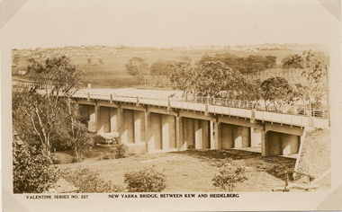 Kew Historical Society Inc
Postcard, Valentine Publishing Co Pty Ltd, New Yarra Bridge, Between Kew and Heidelberg, 1926-1930
Without bridges, Kew remained cut off from the City of Melbourne, only being accessible by Punt. Private and public bridges were constructed from the 1850s, beginning with the Hawthorn Bridge linking Bridge and Burwood Roads. A bridge across the Yarra at Burke Road was created as early as 1873. Since that first wooden bridge, a number of later bridges, typically on concrete pylons have been built, in 1926 and again during the 1970s.Angle view of the new Yarra bridge [ie. The Burke Road bridge] taken from the Kew side, showing the bridge’s structure. Trees line the river’s edge. In the distance can be seen a distant line of houses stretching to the horizon. The river appears to have an S-shaped bend beyond the bridge. The postcard, No. 227, was produced by the Valentine Publishing Co. Pty Ltd., of Queen Street, Melbourne.burke road bridge - kew (vic), bridges - kew (vic) -
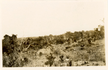
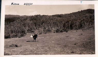 Kiewa Valley Historical Society
Black and white photograph of farmland, Kiewa, 25/8/38, circa 1938
This photograph was taken in August, 1938, some eight years prior to the establishment of Mt. Beauty a a township. The area was still being used for grazing, and the land was eventually acquired from the local land owners by the State Electricity Commission. The construction of the road, from Tawonga to the High Plains, was commenced in April, 1938 and this photograph was taken August, 1938. This allowed men and heavy equipment to be transported to the work sites for the construction of the Kiewa Hydro Electric Scheme. Prior to this access was by bridle trail, either on horse back or on foot. By 1946 housing construction had commenced for the new town of Mt. Beauty and by 1948 street construction in the southern part of the town was completed as far as Hill Street.This photograph is important as it shows the upper Kiewa Valley as it was before the establishment of the town of Mt. Beauty. The land has been cleared of natural vegetation to allow grazing of cattle. Black and white photograph of grazing farmland with one animal standing in the paddock. The area could possibly be where the golf course now stands with the road to the high plains not yet commenced.Handwritten in the upper left hand corner 'Kiewa 25/8/38'. The number 7 has been stamped in the upper right hand corner. It is part of a set of 8 photographs. On the back are the words Velox repeated several times, indicating the type of photographic papergrazing, kiewa, mt. beauty, secv -
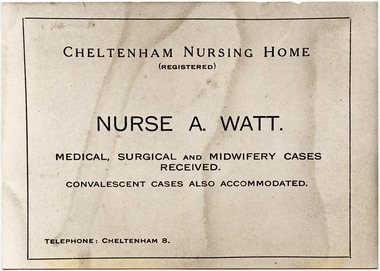 City of Moorabbin Historical Society (Operating the Box Cottage Museum)
Document, Nurse A Watt , Cheltenham Nursing Home c1900, c1900
Nurse A. Watt was a registered Nurse who owned the Cheltenham Nursing Home, located up on the hill, at 200 Charman Road Cheltenham c1900. With Dr. Fleming Joyce, she brought many local identities into the world. Len Allnutt recalls that his brother, Ray, was born there in 1924. Nurse Watt had an excellent reputation for her care and ability in the local area. One recorded event was when in November 1910 Constable Edwards was shot by his son David, at his police house, after an episode of domestic violence involving Constable Edwards long suffering wife - the mother of David. Const. Edwards was first taken to the Police Station, but later taken by Shire ambulance to Nurse Watt's Cheltenham Nursing Home. At 8pm, Edwards was operated on by Dr. Joyce and Dr. Weigall. Despite the surgery, Edwards died the next day of haemorrhage and shock. David was convicted of manslaughter. Dr A Fleming Joyce was the Shire Medical Officer c1914 - 1930. Nurse Watt bequeathed her Estate to the Methodist Church. ( H. Stanley CMHS)c1900 Nurse A Watt had an excellent reputation for her care and ability in the Cheltenham area where Medical, Surgical and Midwifery Cases were received at her Nursing Home in Charman Road. She also accommodated convalescent cases. She worked with Dr A.Fleming Joyce and Dr Weigall.a) Advertisement / Leaflet for Nurse A.Watt c1900 b) Black & White photograph of the Cheltenham Nursing Home, 200 Charman Road Cheltenham c1900watts nurse a, joyce dr. a f., cheltenham nursing home c1910, charman road cheltenham, nursing, medicine, midwifery, victoria police force, smith j l; smith mary ann, stanley helen,, horse drawn carts, toll gates brighton, motor cars 1900, steam engines, early settlers, bentleigh, mckinnon, parish of moorabbin, city of moorabbin, county of bourke, moorabbin roads board, shire of moorabbin, henry dendy's special survey 1841, were j.b.; bent thomas, o'shannassy john, king richard, charman stephen, highett william, ormond francis, maynard dennis, market gardeners, vineyards, orchards -
 Eltham District Historical Society Inc
Photograph, Beard Street, Eltham, 3 Sep 1981
Roll of film taken by Eltham Shire Council officers of roads and houses in the Eltham East area, 3 September 1981 prior to construction of new water main; including views of existing damage to footpaths and gutters and general views of Beard Street. These images provide a perspective of housing estate developments and changes in housing styles and road development which began sweeping in from the mid 1970s with increasing urbanisation of what was once more outlying suburbs and regions.35mm colour positive transparency (1 of 28) Mount - Kodak Kodachrome Cardbeard street, eltham, infrastructure, roads, horse, park road -
 Eltham District Historical Society Inc
Photograph, Foothpath and kerb damage, Bainbridge Drive, Eltham, 3 Sep 1981
Roll of film taken by Eltham Shire Council officers of roads and houses in the Eltham East area, 3 September 1981 prior to construction of new water main; including views of existing damage to footpaths and gutters and general views of Beard Street. These images provide a perspective of housing estate developments and changes in housing styles and road development which began sweeping in from the mid 1970s with increasing urbanisation of what was once more outlying suburbs and regions.35mm colour positive transparency (1 of 28) Mount - Kodak Kodachrome Cardeltham, infrastructure, roads, bainbridge drive, footpaths and gutters -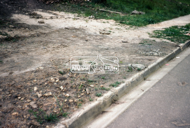
 Eltham District Historical Society Inc
Photograph, Foothpath and kerb damage, Bainbridge Drive, Eltham, 3 Sep 1981
Roll of film taken by Eltham Shire Council officers of roads and houses in the Eltham East area, 3 September 1981 prior to construction of new water main; including views of existing damage to footpaths and gutters and general views of Beard Street. These images provide a perspective of housing estate developments and changes in housing styles and road development which began sweeping in from the mid 1970s with increasing urbanisation of what was once more outlying suburbs and regions.35mm colour positive transparency (1 of 28) Mount - Kodak Kodachrome Cardeltham, infrastructure, roads, bainbridge drive, footpaths and gutters