Showing 46350 items matching "2023-08-11"
-
 Buninyong & District Historical Society
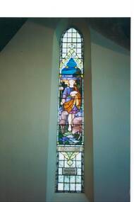
Photograph - Original Photograph, C J Brooks, Presbyterian (now Uniting) Church, Buninyong, interior, stained glass window in memory of R. Gillespie, 9/11/1991
historic building, stained glass window depicting Christ as Shepherd with flock.Colour photo, Presbyterian (now Uniting) Church, Buninyong, interior, stained glass window in memory of R. Gillespie.buninyong, church, presbyterian, uniting, stained glass, gillespie -
 Buninyong & District Historical Society
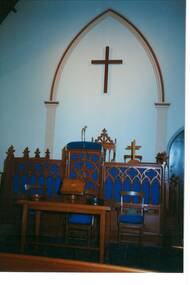
Photograph - Original Photograph, C J Brooks, Presbyterian (now Uniting) Church, Buninyong, interior, Pulpit, chair and Communion Table, 9/11/1991
historic building, original pulpit and communion tableColour photo, Presbyterian (now Uniting) Church, Buninyong, interior, Pulpit, chair and Communion Table, large arch and cross on wallbuninyong, church, presbyterian, uniting, pulpit, communion table -
 Buninyong & District Historical Society
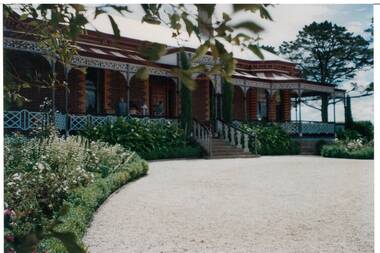
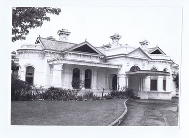
Photograph - Original Photograph, Larundel homestead, Elaine in 1993, 21/11/1993
historic Colour photo, Larundel homestead, Elaine in 1993, side view, driveway.elaine, larundel -
 Buninyong & District Historical Society
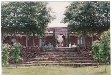
Photograph - Original Photograph, Larundel homestead, Elaine in 1993, side view, 21/11/1993
historic Colour photo, Larundel homestead, Elaine in 1993, side viewelaine, larundel, austin family -
 Marian College
Brigidine Convent Building, 11/06/1889
The foundations of the Convent commenced on 11th June 1889. The first donation towards the building of the Convent was received from an old Irish woman of five shillings. Mr McCabe, a Catholic gentleman from Ararat, deeded a piece of ground on 30th June 1889.The start of the first Catholic school building in Ararat.Two storey Brigidine Convent built with red bricks. Building of the convent commenced on 11th June 1889. Convent was blessed by Bishop Moore on 18th March 1890.brigidine convent -
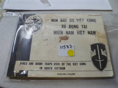 National Vietnam Veterans Museum (NVVM)
Book, Mines and Boobytraps used by Viet Cong in South Vietnam, 1/11/1965 12:00:00 AM
mines, booby traps -
 Moorabbin Air Museum
Document (item) - CAC Wirraway Overhaul Manual, COMMONWEALTH AIRCRAFT CORPORATION PTY LTD, The "Wirraway" Overhaul and Repair Manual, 01/11/40
RAAF Publication No 76 -
Moorabbin Air Museum
Book (Item) - Pratt & Whitney Wasp Engine Logbook for Wirraway, Royal Australian Air Force et al, Aero-Engine Log Book, Wirraway Mark III, A20-744, WASP H S1-H1-G Maker's No.16047, 15/11/45
Maintenance mostly conducted by 25 Squadron. -
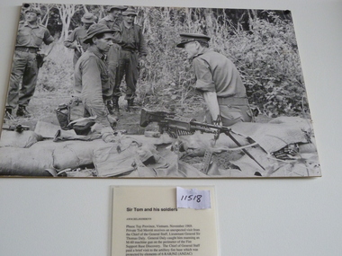 National Vietnam Veterans Museum (NVVM)
Photograph, Sir Tom And His Soldiers, 1/11/1969 12:00:00 AM
Unframed photo showing Pte Ted Merritt receives an unexpected visit fron Lt Gen Sir Thomas Daly. Merritt mas an M-60 machine gun at Fire Support Base discoveryAWM BEL/69m 60, lt gen daly, pte merritt, grar/nz -
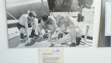 National Vietnam Veterans Museum (NVVM)
Photograph, Mixing The Araldite, 8/11/1968 12:00:00 AM
Unframed photo of fitters of NO35 Sqn RAAF inspecting the wing of a Aqn Caribou. In the background a Caribou is being dismantled for shipping to Australia. Left to right Sgt Fred Ball, Lac Sund, Lac Wayne O'DonohoeAWM VN68-87-1 (2)caribou, no 35 sqn raaf, sgt ball, lac sund, lac o'donohoe, vung tau -
 St Kilda Historical Society
Photograph - Photo map, 11/01/1968
One of a series of photo-maps produced for the Department of Crown Lands and Survey (1857-1983). For correlation with a current map, and access to other historical photo maps of Victoria, see the Historic Photo-Maps Index published by the Department of Environment, Land, Water and Planning at https://services.land.vic.gov.au/DELWPmaps/historical-photomaps/Black and white aerial photographVic 2132 State Aerial Survey Melbourne 1968 Proj Run 27E 11.1.68 5100 ASL 65caulfield north, caulfield park, armadale, malvern, 1968 -
 St Kilda Historical Society
Photograph - Photo map, 11/01/1968
One of a series of photo-maps produced for the Department of Crown Lands and Survey (1857-1983). For correlation with a current map, and access to other historical photo maps of Victoria, see the Historic Photo-Maps Index published by the Department of Environment, Land, Water and Planning at https://services.land.vic.gov.au/DELWPmaps/historical-photomaps/Black and white aerial photographVic 2132 State Aerial Survey Melbourne 1968 Proj Run 27E 11.1.68 5100 ASL 67st kilda east, st kilda cemetery, caulfield north, alma park, balaclava, armadale, 1968 -
 St Kilda Historical Society
Photograph - Photo map, 11/01/1968
One of a series of photo-maps produced for the Department of Crown Lands and Survey (1857-1983). For correlation with a current map, and access to other historical photo maps of Victoria, see the Historic Photo-Maps Index published by the Department of Environment, Land, Water and Planning at https://services.land.vic.gov.au/DELWPmaps/historical-photomaps/Black and white aerial photographVic 2132 State Aerial Survey Melbourne 1968 Proj. Run 27E 11.1.68 5100 ASL 69st kilda, albert park, st kilda east, st kilda beach, alma park, windsor, prahran, 1968 -
 St Kilda Historical Society
Photograph - Photo map, 11/01/1968
One of a series of photo-maps produced for the Department of Crown Lands and Survey (1857-1983). For correlation with a current map, and access to other historical photo maps of Victoria, see the Historic Photo-Maps Index published by the Department of Environment, Land, Water and Planning at https://services.land.vic.gov.au/DELWPmaps/historical-photomaps/Black and white aerial photographVic 2132 State Aerial Survey Melbourne 1968 Proj. Run 28E 11.1.68 5100 ASL 81st kilda, balaclava, st kilda east, ripponlea, elwood, elsternwick, caulfield, st kilda botanical gardens, 1968 -
 St Kilda Historical Society
Photograph - Photo map, 11/01/1968
One of a series of photo-maps produced for the Department of Crown Lands and Survey (1857-1983). For correlation with a current map, and access to other historical photo maps of Victoria, see the Historic Photo-Maps Index published by the Department of Environment, Land, Water and Planning at https://services.land.vic.gov.au/DELWPmaps/historical-photomaps/Black and white aerial photographVic 2132 State Aerial Survey Melbourne 1968 Proj. Run 29E 11.1.68 5100 ASL 194elwood, elwood beach, elwood park, elsternwick park, ripponlea, elwood canal, balaclava, st kilda, 1968 -
 St Kilda Historical Society
Photograph - Photo map, 11/01/1968
One of a series of photo-maps produced for the Department of Crown Lands and Survey (1857-1983). For correlation with a current map, and access to other historical photo maps of Victoria, see the Historic Photo-Maps Index published by the Department of Environment, Land, Water and Planning at https://services.land.vic.gov.au/DELWPmaps/historical-photomaps/Black and white aerial photographVic 2132 State Aerial Survey Melbourne 1968 Proj. Run 27E 11.1.68 5100 ASLst kilda, st kilda west, st kilda pier, catani gardens, st kilda beach, albert park, 1968 -
 St Kilda Historical Society
Photograph - Photo map, 11/01/1968
One of a series of photo-maps produced for the Department of Crown Lands and Survey (1857-1983). For correlation with a current map, and access to other historical photo maps of Victoria, see the Historic Photo-Maps Index published by the Department of Environment, Land, Water and Planning at https://services.land.vic.gov.au/DELWPmaps/historical-photomaps/Black and white aerial photographVic 2132 State Aerial Survey Melbourne 1968 Proj. Run 29E 11.1.68 5100 ASL 196elwood, elwood park, elwood canal, elwood beach, st kilda marina, mc moran reserve, point ormond, 1968 -
 St Kilda Historical Society
Photograph - Photograph Building, The Age newspaper, 11/10/1970
Photograph taken 1970 now Rabbinical Collegeblack and white photograph -
 St Kilda Historical Society
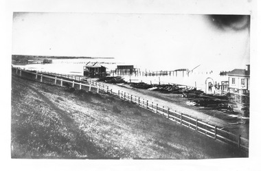
Photograph, The Illustrated Melbourne Post, The St Kilda Baths, 22/11/1862
Wooded debris piled in stacks along foreshore, wooden-post fence separating beach from shrubbery along beachblack and white photograph, copy, unmounted, poor conditionSt. Kilda Baths destroyed by a storm, November, 1862. (Report of storm is illustrated Melbourne Post, 22.11.1862) -
 St Kilda Historical Society
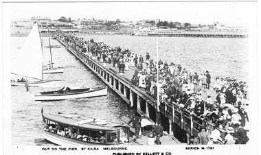
Photograph, Kellett&Co, Out on the Pier. St Kilda Melbourne, 2/11/1926
St Kilda Pier, with Esplanade hotel in background, Alfred Sq. Scene of large crowd , four boats.black and white postcard, unmounted, original, goood conditionPublished By Kellett &Co Series M1781 -
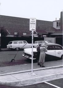
 St Kilda Historical Society
Photograph, Camden Street carpark Balaclava, 11/1962
Opening of carpark Camden Street Balaclava black and white photograph, unmounted, original, good conditionOn back: Car Park opening Camden Street Balaclava Nov 1962. From Leete Chemist -
 St Kilda Historical Society
Photograph, Camden Street carpark, Balaclava, 11/1962
Opening of carpark Camden Street Balaclava black and white photograph, unmounted, original, good conditionOn back: Car Park opening Camden Street Nov 1962 From Leete Chemist -
 St Kilda Historical Society
Photograph, Camden Street carpark, Balaclava, 11/1962
Opening of carpark Camden Street Balaclava black and white photograph, unmounted, original, good conditionOn back: Car Park opening Camden Street Nov 1962 From Leete Chemist -
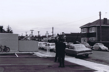
 St Kilda Historical Society
Photograph, Woodstock Street, Balaclava, 1/11/1962
Opening of carpark Camden Street Balaclava black and white photograph, unmounted, original, good conditionOn back: Some of the crowd in Woodstock Street -
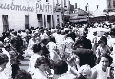
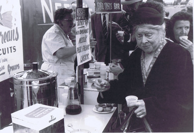 St Kilda Historical Society
Photograph, Marnie Mahong, Camden Street carpark, Balaclava, 11/1962
Opening of carpark Camden Street Balaclava black and white photograph, unmounted, original, good conditionOn back: Opening of Car Park Camden Street Nov 1962. This group of photos from Marnie Mahong. From Leete Chemist -
The Foundling Archive
Drivers Licence, Motorcycle Driver's Licence - George Argo Turner (Senior), 27/11/40
Paper licence, green with red and black ink'Lood and Live' logo Licence number 584 970 -
Clunes Museum
Book, GARRY FENTON, BUSHY'S CUT OUT, 1/11/2018
VERY SOON AFTER TONY WAS DIAGNOSED WITH MND THE TOWN SWUNG INTO ACTION TO HELP ONE OF THEIR OWN...PAPERBACK, COVER OF BOOK IS BROWN WITH PHOTOS OF BUSHY ON FRONT, IN THE BACKGROUND A FLOCK OF SHEEP. 28 PAGESnon-fictionVERY SOON AFTER TONY WAS DIAGNOSED WITH MND THE TOWN SWUNG INTO ACTION TO HELP ONE OF THEIR OWN...shearer, bushy hill, clunes f&n club -
Tatura Irrigation & Wartime Camps Museum
Wallet, World war 11
This wallet belonged to Staff Sergeant Herbert Cubbin, Camp Guard.Khaki woollen wallet. Decorative top stitching on outside. One inside pocket has small cut-out star with blue lining.The other side has a pocket with decorative zig-zag edging. -
Tatura Irrigation & Wartime Camps Museum
Photograph, 20/11/1956
Taken by photographer for State Rivers and Water Supply Commission.Medium sized black and white photograph. Big wash-away under concrete slab at Tatura Waterworks storage / upright posts bottom right corner / sandbags and petrol drum above water line left of centre / water left of bankvictorian state rivers and supply commission, tatura waterworks, tatura waterworks trust -
Tatura Irrigation & Wartime Camps Museum
Photograph, 20/11/1956
Taken by photographer for State Rivers and Water Supply Commission.Medium sized black and white photograph. Big wash-away under concrete slab at Tatura Waterworks storage / Sheets of galvanised iron foreground on slab / bags of sand and petrol drum further along above water level / water on right / tree on horizon.victorian state rivers and supply commission, tatura waterworks, tatura waterworks trust