Showing 10320 items
matching camping
-
 4th/19th Prince of Wales's Light Horse Regiment Unit History Room
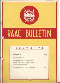
Document - Bulletin, Royal Australian Armoured Corps Bulletin No 32, June 1956
A 6 page document covering RAAC reorganisation, officer postings & promotions etc, course at Armoured School and self evaluation for CMF camp trainingraac bulletin, raac -
 Kiewa Valley Historical Society
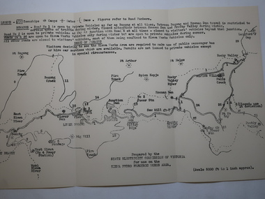
Map - Kiewa Hydro Electric Works Area
An early map of the Kiewa Hydro Electric Scheme Works Area prepared by the SECV for use when requesting access to the area. The regulations are printed regarding permits.During construction of the KHES there were restrictions on access to the area. This map identifies the land marks and states the regulations for entry to the area.Black and white map folded into three showing a legend with the townships, camps, gates and dams marked.Also indicating the roads, rivers, mountains and infrastructure of the KHES. khes works area, map of khes -
 Bendigo Historical Society Inc.
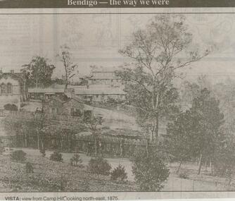
Newspaper - JENNY FOLEY COLLECTION: VISTA
Bendigo Advertiser ''The way we were'' from 2000. Vista: View from Camp Hill, looking north-east. 1875. The clip is in a folder.newspaper, bendigo advertiser, the way we were -
 Bendigo Historical Society Inc.
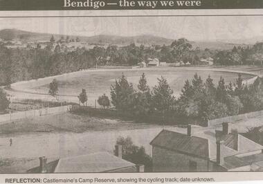
Newspaper - JENNY FOLEY COLLECTION: REFLECTION
Bendigo Advertiser ''The way we were'' from 2001. Reflection: Castlemaine's Camp Reserve, showing the cycling track, date unknown. The clip is in a folder.newspaper, bendigo advertiser, the way we were -
 National Vietnam Veterans Museum (NVVM)
Film - Film, DVD, 1st Australian Field Hospital: Vung Tau, Republic of South Vietnam, 1968-1971
B/w footage of Australian soldiers setting up camp; under fire; getting wounded & being flown to Vung Tau hospital etc.1st australian field hospital -
 Bendigo Historical Society Inc.
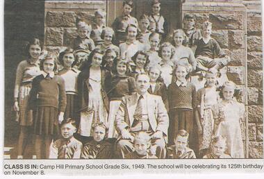
Newspaper - JENNY FOLEY COLLECTION: CLASS IS IN
Bendigo Advertiser "The way we were" from Friday, October 31, 2003. Class is in: Camp hill Primary School grade six, 1949.newspaper, bendigo advertiser, the way we were -
 Tatura Irrigation & Wartime Camps Museum
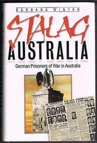
Book, Stalag Australia, 1986
Stalag Australia vividly and accurately reconstructs the story of Germans and their experiences as prisoners of war.Black hard cover book, white dust cover with black and red text and a photo of the monument in Murchison POW Camp 13 on the front cover.stalag australia, german pows, camp 13, dhurringile, ww2 camp 13 -
Tatura Irrigation & Wartime Camps Museum
Coat hanger, 1940-1945
Coat hanger made from fencing wire twisted into shape found in camp 1 65 years after the war ended. Hand made.camp metal work -
Tatura Irrigation & Wartime Camps Museum
Photograph, 1950
Taken by photographer for State Rivers and Water Supply Commission.Medium sized black and white photograph. General view of camp looking west (in 1950) Army huts spread across middle - right to leftvictorian state rivers and supply commission, camp 13, murchison, water commission camp -
Tatura Irrigation & Wartime Camps Museum
Photograph - copy, 1989 copy
Copy of original black and white photograph hut used for assembly of POW's.Copy of black and white photograph. Interior of camp assembly hall. Map of the world covering end wall. Decorations hanging from ceiling rafters.camp 13, murchison victoria, internment camps, internment camp buildings -
Tatura Irrigation & Wartime Camps Museum
Document, Material from Australian Archives, United Kingdom Internees, 30 August 1991
Made available by the Australian Archives courtesy E. Carey.Blue back clear plastic fold containing list of United Kingdom Internees held in camp 2 Tatura from 15 December 1942.united kingdom internees, camp 2 united kingdom internees -
Tatura Irrigation & Wartime Camps Museum
Book, Sugar, Tears and Eyeties, 1994
Tells of the history of the Delseno family, being Italian in Australia, with the social life and customs of the time.THSoft, colourful cover depicting water colour painting of internees in a camp, with guard tower and surrounding countryside in the background. Book title is printed in colour Cover painted by Ivy Zappala of Bellenden Ker. The author Peter Dalenso has autographed each of the three copies with the date,1994 added. -
Tatura Irrigation & Wartime Camps Museum
Book - memo, 1940's
Notebook with English words with German translation beside. Use by Karl Wied to learn English language whilst in Camp 3. All entries in ink. -
Williamstown High School
Letter to School Council 1994
The Finn Koren Collection.A letter to school council asking for in principal support a music camp to Tasmania, which would include tuition, workshops, rehearsals, performances and sight seeing.williamstown high school, camps, 1994, tasmania, school council -
 8th/13th Victorian Mounted Rifles Regimental Collection
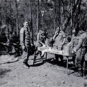
Photograph
Echelon area was a grouping of administrative and support elements of a squadron located behind forward elements. Usually contained fuel, water and ration vehicles, LAD and medical aid vehicle.Black and white photograph of 8/13Victorian Mounted Rifles soldiers at a hasty lunch point in an echelon area during Annual Camp, Puckapunyal, 1971." Cpl Frohling, Cfm Maddocks, Lt Shefford, Cfm Martin " Soldier at right not known. -
 Australian Army Museum of Western Australia
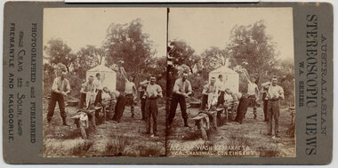
Stereographic Image, 1900
The 1st Contingent departed Fremantle on 7 November 1899 and returned on 29 December 1900. The 2nd Contingent departed 3 February 1900 and returned 8 December 1900. Due to the shortage of khaki material, the 1st Contingent uniforms wore their blue militia tunics, blue puttees and a dark blue puggaree on departure. An Anglo Boer War Service of Reconciliation is held annually on the first Sunday in June at the "Fallen Soldiers" (Boer War) Memorial in Kings Park attended by descendants and representative of all combatant nations. The date selected is the closest Sunday to the date of signing of the Treaty or Peace of Vereeniging (31 May 1902). The culmination of the service is the laying of the Emily Hobhouse wreath.Unique series of stereoscopic images showing both the 1st and 2nd West Australian Mounted Infantry Contingents to the Anglo Boer War. Images contain details of uniforms, accoutrements, camp life, civic honours and departure.A Camp Wash Karrakatta. WA Transvaal Contingent. Published in Australian Stereoscopic Views, WA Series, Photographed and published by Craig and Solin, Fremantle and KalgoorliePhotographed and published by Craig and Solin, Fremantle and Kalgoorliestereoscope, boer war, south africa, capetown -
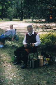 Bendigo Historical Society Inc.
Photograph - PETER ELLIS COLLECTION: BUSH SETTING, 1st January, 1987
Colour photograph. Man in camp chair with concertina, accordian at his feet. Woman in chair. Bush setting. Date stamped '87 1 1.photo, individual, peter ellis -
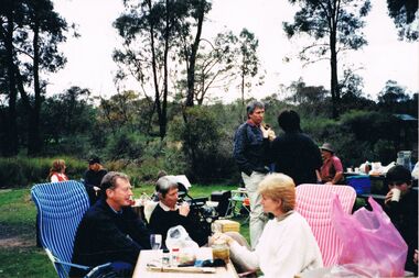 Bendigo Historical Society Inc.
Photograph - PETER ELLIS COLLECTION: DANCE CLUB PICNIC
Colour photograph. Picnic. People in camp chairs. Bush setting. Back of photo reads: Dance Club Picnic 9/95 Whipstick - Bendigo. -
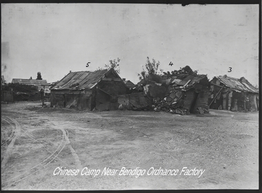 Bendigo Historical Society Inc.
Photograph - Bendigo Munitions Factory (ADI) Photos, Australian Defence Industries (Now THALES AUSTRALIA), c1942-1960
The Bendigo Ordnance Factory began operating in 1942, producing heavy artillery and naval guns. In the late 1990s the then Federal Government-owned facility was sold to the multinational Thales, which continues to operate the factory today. The Ted Hocking collection of photos were digitized onto two CDs in 2014. As well the Bendigo Historical Society has a collection of glass negatives includes some slides of women working in the munitions factory. Seven slides were included in an album that was prepared for Dr Edith Summerskill who visited Australia in 1944 as part of an Empire Parliamentary Delegation. The album included photographs of Australian women working at the factory during WW2. A copy of the album is in the Collection of the Australian War Memorial.Three photos of the Chinese Camp near the Bendigo Munitions Factory, later known as the Ordnance Factory and then the Australian Defense Industries. The photos are of houses and shops.history, bendigo, bendigo munitions factory, bendigo ordnance, bendigo adi, doctor edith summerskill, ww2, slide box 1 10165, slide box 2 10166, slide box 3 10167, ted hocking collection, bendigo chinese -
Bendigo Historical Society Inc.
Book - School Exercise book, Michael Parry exercise book, about 1960s
The Parry family consisted of Cynthia (nee Walsh)5/4/1926 - 5/2/2018 who married John Stuart Parry 1/1/1925 - 1/6/2009 in 1949. They had the following children:-Timothy, Michael, Deborah, Daniel, Catherine and Steven.Camp Hill, Bendigo Grade 2 Exercise Book belonged to Michael Parry 9 mm blue ruled brown paper cover. 1973history, bendigo, camp hill school, j s parry collection -
 8th/13th Victorian Mounted Rifles Regimental Collection
Photograph - Tucknott
On 1 April 1991, ‘A’ Squadron 8/13 Victorian Mounted Rifles linked with 4/19 Prince of Wales’s Light Horse Regiment to form a new regiment of two squadrons: VMR Squadron and PWLH Squadron. The 4/19 Prince of Wales’s Light Horse title was retained, but the VMR Squadron continued to wear the VMR hat badge.Black and white photograph of Sergeant G Tucknott, VMR Squadron 4/19 Prince of Wales's Light Horse at camp, Puckapunyal, September 1992.military, vmr, pwlh, puckapunyal -
 Linton and District Historical Society Inc
Domestic object - Tag, Plug Tobacco Tag, circa 1890
Small, round metal tag from plug tobacco. Look Out brand, found at an old Chinese camp at Misery Creek, Berringa, Victoria.tobacco, smoking, misery creek, berringa, chinese, miners -
 Lakes Entrance Historical Society
Photograph - Lake Tyers, Phillips Miss L, 1900 c
Miss Phillips album donated by R ClarkBlack and white photograph of a fishermen's camp at Lake Tyers, showing two tents and a timber hut on shore of calm waterway. Lake Tyers Victoriawaterways, camp, fishing -
 Lakes Entrance Historical Society
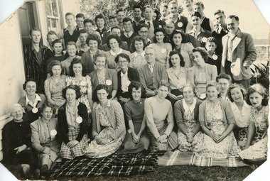
Photograph, 1950
Also enlarged copy 12.5 x 18 cm. copied 2006Black and white photograph showing about 50 young adults with leaders including Rev and Mrs Paton at a Presbyterian Camp, Lakes Entrance, Victoria religion, people -
 Lakes Entrance Historical Society
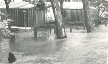
Photograph, Bairnsdale Advertiser, East Gippsland Floods 1988, 1/11/1988 12:00:00 AM
Also two other black and white photographs of raging flood waters during same flood event. 04933.1 10 x 17 cm and 04933.2 18 x 24.5 cmBlack and white photograph showing flood waters flowing through a camping park with two large tents and a caravan surrounded East Gippsland Victoriaoil and gas industry -
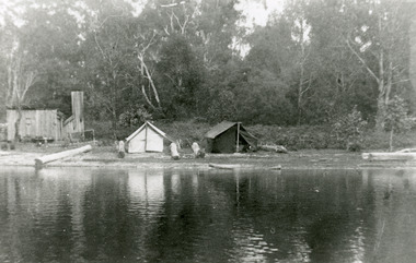
 Kiewa Valley Historical Society
Black and white photograph of Surveyor's Camp, 1938, Kiewa River and surveyor's Camp 25/8/38, 25/08/1938
Surveying under the prevailing conditions at this time was an arduous and demanding task. There were no roads beyond Tawonga and access was by bridle tracks, on foot or horseback. This camp was to provide accommodation to those men who were surveying the road from South Tawonga to the Bogong High Plains which was commenced in April, 1938. The actual work was undertaken by the Country Roads Board, on behalf of the State Electricity Commission, using three Caterpillar diesel crawler tractors equipped with Kay Bruneriei (Brunner) lhydraulically operated trailbuilders (angle dozers)This photograph shows the primitive living conditions that were endured by those carrying out the initial field investigations and surveys for the Kiewa Hydro Electric Scheme. It is possibly one of the few photographs in existence of this camp and of the very rustic timber foot bridge across the West Kiewa river. It has been taken from approx. 100m up Simmonds Creek Road. A black and white photograph showing a small, timber foot bridge across the West Kiewa River. There is a man standing on the bridge and two small huts on the far side of the river, against a backdrop of Mt. Beauty and Mt. Bogong.At the top of the photograph, handwritten in black ink is the inscription "Kiewa River and Surveyor's Camp 25/8/38". The number 4 is stamped towards the right upper corner. On the back, in a circle, about 1.3cm in diameter, are the words "Kodak Print". The word "Velox" is faintly discernible on the back as well.surveyor, tawonga, west kiewa river, bridge, camp, secv -
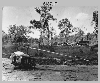 Bendigo Military Museum
Photograph - Bell 47G-2 helicopter used in Royal Australian Survey Corps Field Operations, c1965
This is a set of four photographs of Bell 47G-2 helicopters used in Royal Australian Survey Corps Field Operations. c1965. From 1957, helicopter transport of survey parties revolutionised transport in remote areas. The most common helicopter used by the Royal Australian Survey Corps at this time was the civilian Bell 47G-2 and the Sioux, the Australian Army’s’s equivalent. equivalent. From 1964 an Aerodist MRC2 airborne Electronic Distance Measuring (EDM) system was extensively used for topographic surveys over long distances by trilateration to replace traverse requiring survey station intervisibility. In 1965 the command field survey unit personnel attached to the Army Survey Regiment’s Topographic Squadron were used mainly in support roles such as station clearing, tower operations, station monumenting, Aerodist computations, forward base operations, geodetic observations on the north-south traverse and logistic support for Remote teams. .1P is a photo of a civilian Bell 47G-2 helicopter Registration / Serial VH-UTB owned by Helicopter Utilities from Mascot, NSW c1965. In the background of this photograph is three personnel and vehicles at a field survey camp. The left-hand vehicle is a Willys Jeep with trailer and on the right is probably a Truck, 2 1/2 ton, 6x6, General Service GMC. The Bell 47G-2: VH-UTB was destroyed, and its pilot killed in tragic circumstances during a civilian survey operation on Cape York Peninsula in June 1966. .2P is a photo of a a civilian Bell 47G-2 helicopter Registration / Serial VH-IHB taken in Wyndham, WA. As the letters ‘TAA’ appear on the fuselage, the helicopter was charted from Trans Australian Airways. .3P is a photo of a Bell 47G-2: VH-UTC with survey camp in background. .4P is a photo of a Bell 47G-2 equipped with floats and unidentified personnel loading stores, possibly in Darwin. Acknowledgement: Royal Australian Survey Corps – Aerodist Years 1964-1975 Version 2021.0 Authored by Peter Jensen.This is a set of four photographs of civilian Bell 47G-2 helicopters used in Royal Australian Survey Corps Field Operations. c1965. The photographs were printed on photographic paper and are part of the Army Survey Regiment’s Collection. The photographs were scanned at 300 dpi. .1) - Photo, black & white, c1965, Bell 47G-2 helicopter: VH-UTB with survey camp in background. .2) - Photo, black & white, c1965, Bell 47G-2 helicopter: VH-IHB with survey station in foreground. .3) - Photo, black & white, c1965, Bell 47G-2 helicopter: VH-UTC with survey camp in background. .4) - Photo, black & white, c1965, Bell 47G-2 helicopter: Unidentified personnel loading stores possibly in Darwin..2P – annotated on bottom of photo ‘Wyndham Area – Helicopter drops observing party’ The other photographs are not annotated.royal australian survey corps, rasvy, army survey regiment, army svy regt, fortuna, asr, surveying -
Ringwood and District Historical Society
Document, Ringwood Technical School, 1982 - Policies, Structures, Roles, SRC, Camp Duncan Rules etc
Set of Documents describing school policies, structure, roles, SRC, Camp Duncan, subject coding, emergency procedures etc. Scanned in 6 parts due to volume of pages. Most pages are not numbered. Donated by Joan Pickford (nee Dear) 2022. (Prefect 1970-71). The Index pdf lists the contents of each part but is repeated here: Part 1 • General Educational Policy • Procedures Adopted By The Curriculum Board In Order To Implement The Educational Policy Part 2 • School Administrative Structure o Operational Structure - Operations Committee o Curriculum Board o Org Chart • Role of the Senior Teacher • Role of Head of Department • Role of Assistant with Responsibility • Role of Year Level Coordinator • Role of Section Leader Part 3 • Role of the Welfare Officer • Bell Times 1983 • School Layout • Evacuation Procedure and Diagram • Recording of Students’ Attendance • Staff Absences • Concerning School Rules Part 4 - SRC • Students; Representative Council – Constitution and Rules Part 5 – Camp Duncan, Excursion etc • Camp Duncan Disposition of Duties 1983 • Receipts/forms pro-forma • Some Facts About Camp Duncan • Camp Duncan Date 1983 • Student Checklist and Luggage Requirements for Camps and excursions • Confidential Medical Report for School Camps • Parental Permission Form Part 6 • Education Department Victoria o Pay Advice and Allowance Table o Subject Coding o Leave o General Advice on Transfers o Excursion procedure, Approval Form • Student Assembly Points rts, ringwood tech -
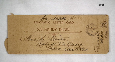 Bendigo Military Museum
Card - PANORAMIC LETTER CARD, Hotocrom Co. Ltd, c.1916
Sent home by Capt. Frederick Baxter MC. Part of the Baxter Collection. Refer Cat No.4219.Cream colour panoramic card Salisbury Plain. Inside 4 pages with 8 images of Army Barracks or tourist sites. On front is address sent to in Australia, Post Office stamp and signed off by Battalion. Photos are all labelled as per inscription and held together by one staple.Photo's labelled. Top written "On Active Service". 1. 40857 Bulford Camp. 2. 48060 Bulford Camp B Lines. 3. 36891 Bulford Camp near Salisbury. 4. 36868 Salisbury Plain, Tidworth Barracks. 5. 36889 Bulford The Bridge. 6. Amesbury, Queensbury Bridge. 7. 32482 Salisbury Stonehenge. 8. 32478 Salisbury Cathedral.letter card, baxter collection, ww1, baxter mc -
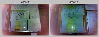 Bendigo Military Museum
Photograph - 4th Field Survey Squadron – Operation ARIGHT 91, Queensland, 1991
This is a set of 16 photographs taken during 4th Field Survey Squadron’s deployment on Operation ARIGHT 91 in Queensland from the 8th of July to the 5th of September 1991. The area of operations was the top end of the Cape York Peninsula, islands of the Torres Strait and the southern coast of PNG. Field parties utilised Texas Instruments TI4100 Global Positioning System receivers. Concurrent with GPS operations Doppler point positioning observations were carried out by field parties using Magnavox MX 1502 receivers on six of the control points. Two Bell UH-1H Iroquois helicopters from RAAF’s 171 COMD and Liaison Squadron were primarily used to deploy GPS field parties. Identification photography of control points was taken by air camera operators in AAAvn Pilatus Porter aircraft from 173 Gen Spt Sqn fitted with an RC10 aerial camera.This is a set of 16 photographs taken in 1991 during 4th Field Survey Squadron’s deployment on Operation ARIGHT in Queensland. The colour photographs are on 35mm negative film and are part of the Army Survey Regiment’s Collection. The photographs were scanned at 96 dpi. .1) to .3) - Photo, colour, 1991. Area of Operations (AO) coordination maps. .4) - Photo, colour, 1991. GPS acquisition post-processing. L to R: LT Simon Buckpitt, SSGT Steve Winner, WO2 Ken Talbot-Smith. .5) to .6) - Photo, colour, 1991. Base camp unidentified personnel. .7) - Photo, colour, 1991. L to R: OPS WO - WO2 Ken Talbot-Smith, DET SSM WO1 Stevo Hinic. .8) - Photo, colour, 1991. Base camp unidentified personnel. .9) - Photo, colour, 1991. Base camp L to R: unidentified (x2), OPS WO - WO2 Ken Talbot-Smith. .10) - Photo, colour, 1991. Base camp unidentified soldier. .11) - Photo, colour, 1991. Base camp L to R: CPL Andy Love, unidentified, SGT Steve McGuiness. .12) - Photo, colour, 1991. Base camp at Horn Island Army Compound. .13 to .16) - Photo, colour, 1991. Unknown locations in Area of Operations..1P to .16P – There are no personnel identified. ‘1991 OP ARIGHT’ annotated on negative sleeve.royal australian survey corps, rasvy, 4 fd svy sqn, op aright 91