Showing 176508 items
matching streets
-
 Eltham District Historical Society Inc
Photograph, Streetscapes around little Eltham area, c.1999, 1999
... streets ...Streetscape evolutionRoll of 35mm colour negative film, 2 stripsKodak GC 400-6streets -
 Eltham District Historical Society Inc
Photograph, Streetscapes around little Eltham area, c.1999, 1999
... streets ...Streetscape evolutionRoll of 35mm colour negative film, 2 stripsKodak GC 400-6streets -
 Eltham District Historical Society Inc
Photograph, Streetscapes around little Eltham area, c.1999, 1999
... streets ...Streetscape evolutionRoll of 35mm colour negative film, 2 stripsKodak GC 400-6streets -
 Eltham District Historical Society Inc
Photograph, Streetscapes around little Eltham area, c.1999, 1999
... streets ...Streetscape evolutionRoll of 35mm colour negative film, 2 stripsKodak GC 400-6streets -
 Eltham District Historical Society Inc
Photograph, Streetscapes around little Eltham area, c.1999, 1999
... streets ...Streetscape evolutionRoll of 35mm colour negative film, 2 stripsKodak GC 400-6streets -
 Eltham District Historical Society Inc
Photograph, Streetscapes around little Eltham area, c.1999, 1999
... streets ...Streetscape evolutionRoll of 35mm colour negative film, 2 stripsKodak GC 400-6streets -
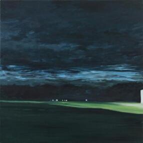 Darebin Art Collection
Painting, David McLeod, Incandescent, 2011
... Streets ...streets -
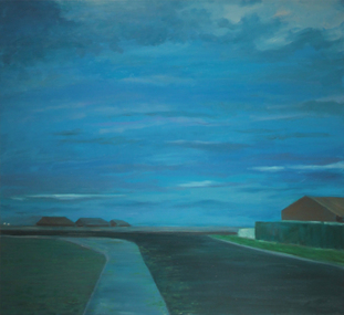 Darebin Art Collection
Painting, David McLeod, Submerged, 2012
... Streets ...streets -
 Victorian Interpretive Projects Inc.
Photograph - digital, LJ Gervasoni, Murtoa Mechanics Hall 0034, August 2011
This hall is located at 37 Duncan Street, Murtoa, Victoria, 3390Digital colour photograph showing the double storey Murtoa Mechanics Hall in the main street.murtoa mechanics hall, murtoa, mechanics institute -
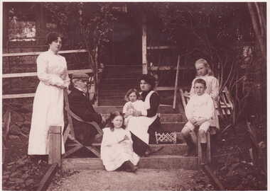 Clunes Museum
Photograph
SEPIA COPY OF PHOTOGRAPH OF MCLENNANS OF LUGG STREET, CLUNES 1911.PHOTOGRAPH - SEPIA COPY OF McLENNANS OF LUGG STREET, CLUNES, 1911.WITH THE NANNY AGNES WAKENSHAWLEFT TO RIGHT-ANNE McLENNAN, LACHLAN McLENNAN (SNR.), KATHLEEN McLENNAN, WINIFRED McLENNAN, MARY WAKENSHAW (THE NANNY), LACHLAN McLENNAN, AGNES WAKENSHAW.local history, photography, photographs, crick, shrigley, mc lennan, lazarus -
 City of Kingston
Pamphlet - Colour, W. H. Wood Estate Agent, Subdivisional Land Auction Barker's Estate Cheltenham, 1919
Sales plan for land in the suburb of Cheltenham, along Barker StreetThe developing urban area of Cheltenham within the City of Kingston. This land sale pamphlet illustrates the subdivision of land within the municipality and the changing demographic of the district as new houses are constructed.Colour pamphlet advertising subdivisional land auction of Barker's estate, on Barker Street Cheltenham.Handwritten in grey pencil on the subdivision map: a series of numbers on each block possibly indicating the sale price. Handwritten in grey pencil on the subdivision map: Roy- joined to subdivision 6 Handwritten in grey pencil on the subdivision map: x on the border between subdivision 17 and 16, and again on the border between subdivision 12 and 11.cheltenham, land sales, estate -
 Lakes Entrance Regional Historical Society (operating as Lakes Entrance History Centre & Museum)
Photograph, Wally Stephenson, 1982 c
Also three other photographs taken of west side of Myers Street showing Silver Sands Caravan Park 05209.1, .2, .3 5 x 10 cmColour photograph of Lakes Central Flats on corner of Myer Street and Church Street looking West from Police Station showing flowers in garden at roundabout Lakes Entrance Victoriabusinesses -
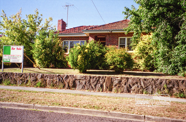
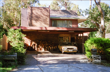
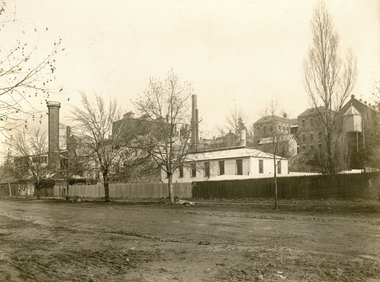
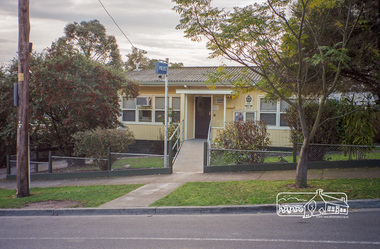 Eltham District Historical Society Inc
Photograph, Margaret Ball, Police Station, Pryor Street, Eltham, June 1999, 1999
... streets ...In 1959 the Victoria Police purchased this house in Pryor Street to be refurbished as the Eltham Police Station. In 1961 the Police moved out of 728 Main Road and into the Pryor Street building following required modifications to bring it in line with the standards used for Police Stations throughout the State.The Margaret Ball (Pre 1960s Houses) Collection was a personal project initiated to mark the year 2000 and arose as a result of the disappearance of many pre-1960s parts of Eltham due to development. Approximately 200 pre-1960s style houses that were left in Eltham between Main Road and east to Bible Street, between Cecil Street to the north and south to Dalton Street were photographed in late 1999. Not all of the houses could be photographed; some because the garden or trees blocked the view of the house, others because of rubbish or cars were in the way, some because people were working on the house or in the gardens at the time.Roll of 35mm colour negative film, 10 stripsFuji 200eltham, houses, streets, margaret ball (pre 1960s houses) collection, pryor street, police station -
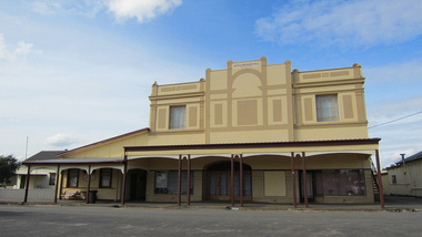
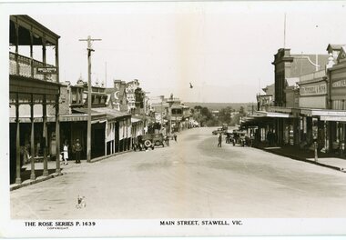 Stawell Historical Society Inc
Photograph, Main Street Stawell looking west towards the Post Office Rose series 1639
This photograph is of Main Street Stawell lookingwest around c 1930's. The photo was taken from the Bull and Mouth Hotel whis is on the left side and other business. On the road are a few people and cars.Black and white Postcard Rose Series 1639 Looking down Main St From the Bull and Mouth Hotel Partially visable on the left. The Rose series, P 1639 Main Street, Stawell, Victoriastawell business shops streetscape -
 Federation University Historical Collection
Photograph - Photograph (Black & White), Mines Department, Back View School of Mines Ballarat, c 1900
The Albert Street end of the Ballarat School of Mines Campus included the Gauge Tower [designed by Henry R. Caselli] and the Mining Laboratory. The buildings shown along Albert Street have been demolished to make way for the M.B. John Building and the Flecknoe Building. Black and white photograph mounted onto green card. Shows the Ballarat School of Mines from Albert Street. The Henry Caselli designed Gauge tower is located on the left hand side of the photo, and Albert Street is an unmade dirt road.Written onto bottom of photo 'Back View School of Mines Ballarat. Mines Dept.ballarat school of mines, albert street, henry caselli, henry richards caselli, hr caselli -
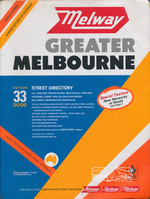 Eltham District Historical Society Inc
Book, Melway Publishing, Melway Greater Melbourne street directory : including Geelong, Phillip Island, Healesville, Kinglake, Gisborne, Lorne, Wallan, Bacchus Marsh Bellarine & Mornington Peninsulas; Edition 33, 2006, 2005
Edition 33. 2006 Coloured detailed maps accessed by a street or location index. Cover: Totally revised and updated with over 1380 new street listings new maps covering Mount Duneed on the Bellarine Peninsula, Pakenham South and Rythdale. Detailed public transport routes - train, tram, bus, bicycle paths & shared road routes. Eastlink fully detailed new Craigieburn bypass GPS compatible WGS/MGA Grid Special feature: New Hierachy of Roads Street directory with plastic cover, coloured maps, 902 pagesstreets,roads,melbourne,map,melway -
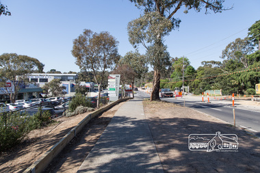 Eltham District Historical Society Inc
Photograph, Peter Pidgeon, Bolton Street upgrade, Eltham, 13 November, 2017, 13/11/2017
... streets ...North bound lane closure, near Bridge Street, McDonalds on left. Born Digitalbolton street, bolton street upgrade, eltham, streets, eltham ridge, shops -
 Clunes Museum
photograph, KODAK PRINT
PHOTOGRAPH OF JUNCTION OF FRASER & BAILEY STREET, CLUNES. FIRE BRIGADE REEL SHED IN FOREGROUND. LUFF'S TWO STOREY HOUSE IN BACKGROUND.ORIGINAL SEPIA PHOTOGRAPH OF VIEW OF CLUNES,TAKEN FROM FRASER STREET.local history, photography, photographs, clunes township -
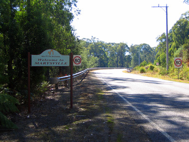 Marysville & District Historical Society
Photograph (Item) - Colour photograph, Travel Victoria, 2004
A colour photograph of Murchison Street in Marysville in Victoria.A colour photograph of Murchison Street in Marysville in Victoria. Shows the sign 'Mist Of The Mountains', Welcome to MARYSVILLE' sign that used to greet visitors to Marysville before the 2009 Black Saturday bushfires.murchison street, marysville, victoria, photograph, mist of the mountains, 2009 black saturday bushfires -
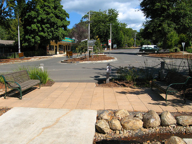 Marysville & District Historical Society
Photograph (Item) - Colour photograph, Travel Victoria, 2006
A colour photograph of Murchison Street in Marysville in Victoria.A colour photograph of Murchison Street in Marysville in Victoria. Shows the view looking up Pack Road. The buildings that can be seen in the photograph were all destroyed in the 2009 Black Saturday bushfires.murchison street, pack road, marysville, victoria, photograph, 2009 black saturday bushfires -
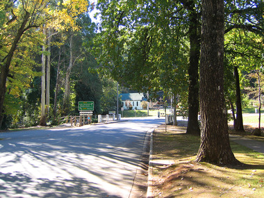 Marysville & District Historical Society
Photograph (Item) - Colour photograph, Travel Victoria, 2006
A colour photograph of Murchison Street in Marysville in Victoria.A colour photograph looking down Murchison Street in Marysville in Victoria. The Christ Church was destroyed in the 2009 Black Saturday bushfires.murchison street, marysville, victoria, christ church, photograph, 2009 black saturday bushfires -
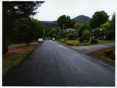 Marysville & District Historical Society
Photograph (Item) - Colour photograph, Unknown
A colour photograph of Darwin Street in Marysville in Victoria.A colour photograph of Darwin Street in Marysville in Victoria. Darwin Street was named after Charles Robert Darwin. Charles Robert Darwin was an English naturalist, geologist, and biologist, widely known for his contributions to evolutionary biology. His theory that all species of life have descended from a common ancestor is now generally accepted and considered a fundamental concept in science. In a joint publication with Alfred Russel Wallace, he introduced his scientific theory that this branching pattern of evolution resulted from a process he called natural selection, in which the struggle for existence has a similar effect to the artificial selection involved in selective breeding. Charles Darwin has been described as one of the most influential figures in human history and is buried in Westminster Abbey. charles robert darwin, darwin street, marysville, victoria, photograph -
Clunes Museum
Financial record - LEDGER
Used in Theo Harden's Boot and Shoe Emporium in Fraser Street Clunes. Received from Anne and Dennis Robinson of 126 Bailey Street, ClunesLeather ledger with green cover and red "Ledger" label on spine. From Harden's Shoe Shop in Fraser Street.local history, books, ledgerbusinesses of clunes -
 Stawell Historical Society Inc
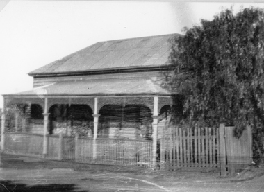
Photograph, Upper Main Street Stawell with a Weatherboard Home – Reeve Family
The Photgraph of a Weatherboard Home which was situted Upper Main Street on the left side of the street– It was the home of the Reeve Family. Black and White photgraph of a weatherboard home with veranda across the front, around which a wooden fence and gateway, onto the street.stawell, reeve -
 Warrnambool and District Historical Society Inc.
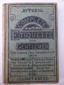
Book, The Complete Etiquette for Gentleman, c.1890
This book has the sub-title: ‘A Complete Guide to the Table, the Toilette and the Ball Room with hints on Courtship, Music and Manners’. It was sold in Warrnambool at the book shop of C. & R. Lavery. They were early Warrnambool settlers and opened their bookselling and newsagent business in 1877. The shop was in the Oddfellows Hall in Koroit Street. This book is of interest as an example of the type of book produced in the late 19th century as an instructional manual for men in the area of manners and etiquette. It is also of interest because it was sold by a local bookstore in Warrnambool. This is a hard cover book of 184 pages. The cover is green with black lines on the cover edges and the titles printed in black lettering. The book has several pages at the front and the back giving information on other books produced by the same publisher (Ward, Lock, Bowden & Co.). These advertisements are accompanied by black and white illustrations. The book has an introduction and 24 sections on etiquette for men for various places and occasions. Each section starts with an ornamental first letter in black and white. The book cover has partly come apart from the pages and the cover is somewhat stained and very faded on the spine. Several of the pages at the back are torn and stained with some of the text missing. There is a label with the sellers’ information pasted on to the back of the front cover. ‘C. & R. Lavery Booksellers Koroit Street Warrnambool’ lavery family, warrnambool, history of warrnambool -
 Clunes Museum
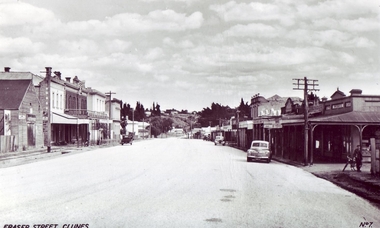
Photograph, KODAK, 1942-52
CLUNES MAIN STREET, CAMP PARADE IN BACKGROUND..1 .2 BLACK AND WHITE POSTCARD PHOTOGRAPH OF FRASER STREET, CLUNES. CURRENT CLUNES MUSEUM ON LEFT WITH CLUB HOTEL AND OLD BANK BUILDINGS. CARS IN MAIN STREET. .3 BLACK AND WHITE COPY OF THE ABOVE PHOTOGRAPH PRINTED ON GLOSS PHOTOGRAPHIC PAPERphotographs, museum ect., clunes township -
 Surrey Hills Historical Society Collection
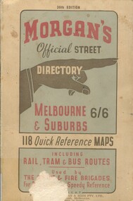
Book, Morgan's Official Street Directory, c1940s
incl.index. This Street Directory of Melbourne and suburbs, c1940s, includes a list of suburbs, their mileage from the city and how to reach them; an index to localities as well as the index to streets appearing on the maps. It also shows bus routes, railways and tramways routes on the maps.incl.index. This Street Directory of Melbourne and suburbs, c1940s, includes a list of suburbs, their mileage from the city and how to reach them; an index to localities as well as the index to streets appearing on the maps. It also shows bus routes, railways and tramways routes on the maps.melbourne metropolitian area, suburbs, cities and towns, maps -
 Eltham District Historical Society Inc
Book, Melway Great Melbourne street directory including Geelong, Phillip Island Healesville, Bellarine & Mornington Peninsulas, 1998
... streets ...25th edition. Coloured detailed maps accessed by a street or location index. Cover: (Includes) New Southbank map including Crown Complex, enlargements of Footscray and Kensington, bike paths, walking tracks & horse trails, latest public transport information, South east Australia tours maps, Vic Roads new route numbers, map of Australia1 atlas (22, 772 p.) : col. maps ; ISSN 03113957streets, maps, roads, melbourne -
Tatura Irrigation & Wartime Camps Museum
Photograph - copy, D. Clark, Waiting for the Queen 1954, 1989 copy
Crowds lined Hogan Street, Tatura, as Queen Elizabeth and Prince Phillip drove down Hogan Street. The Royal car can now be hired for weddings.Black and white copy of photograph of crowds waving to the Royal couple in Hogan Street. T. Flanagan's house in background.on back: Royal Visit 1954 -
Tatura Irrigation & Wartime Camps Museum
Photograph, D. Walker, Criterion Hotel Tatura 1986, 1986
Photograph of Criterion Hotel, Hogan Street, Tatura 1986. The original Criterion, a one storied buildings built by P. F. Ryan, Rochester c 1874. Present hotel erected in 1901. Later owners included D. Heapy, T. Quinn, M. Fletcher. Guardian office is in hotel building.Black and white photograph of Criterion Hotel, Tatura 1986.on back: Criterion Hotel 1986 Hogan Street Tatura.criterion hotel tatura, d. heapy, t. quinn,, m. fletcher., guardian office