Showing 1830 items
matching church buildings
-
 Rutherglen Historical Society
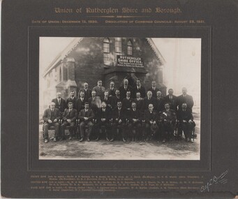
Image, Alf L. Bowden, The Studio, Union of Rutherglen Shire and Borough, 1920 (Exact)
Copy of a photograph of Wesleyan Church used as temporary Shire Office during building of new office. Group portrait of Councillors in front of building."Union of Rutherglen Shire and Borough / Date of Union: December 15, 1920. Dissolution of Combined Councils: August 25, 1921. Rutherglen Shire Office. The Secretary Attends Monday & Friday 10am till 4pm" Front row (left to right) Ex. Cr. S.P. Gollings, Cr. R. Ready, Cr. E.E. Cock, Cr. J. Burch (Ex Mayor), Cr. C.H. Morris (Shire President), J. Hiskins (Ex President), Cr. R.J. Burrowes, Cr. D.B. Smith, Cr. P. Gullifer / Centre Row (left to right) Cr. H.G. Richards, Cr. W.H. Chambers, Cr. R.H. Berryman, Cr. R.J. Harvie, Cr. W.R. McRae, Cr. W.V. McDonald, Cr. C.L. Dobbin, Cr. R.A. McLaurin, Cr. P.M. Seymour, Cr. M.T. Graham, Cr. F. Fuge, Cr J. Milthorpe / Back Row (left to right) T. Trenen (Editor "Sun"), P. Lingford (Shire Engineer), W.C. Bayliss (Banker), A.H. Thompson (Shire Secretary, A.C. Carter (Inspector), N.F. Turnbull (Assistant Secretary)" -
 Rutherglen Historical Society
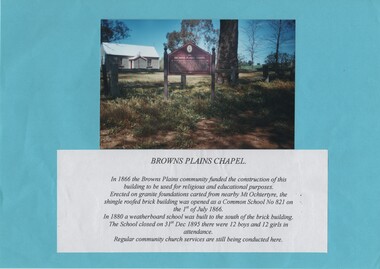
Image, c1985
Colour photograph of a small painted brick building with a story board in front of it. The photograph is mounted on a bright blue sheet of paper, along with a typed caption of the text from the story board.Caption text: "Browns Plains Chapel. In 1866 the Browns Plains community funded the construction of this building to be used for religious and educational purposes. Erected on granite foundations carted from nearby Mt Ochtertyre, the shingle roofed brick building was opened as a Common School No 821 on the 1st of July 1866. In 1880 a weatherboard school was built to the south of the brick building. The School closed on 31st Dec 1895 there were 12 boys and 12 girls in attendance. Regular community church services are still being conducted here."browns plains, churches, schools, common school no 821 -
 Rutherglen Historical Society
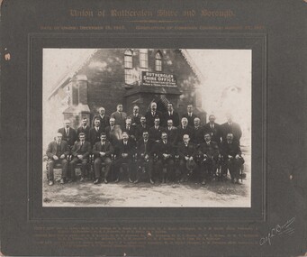
Photograph - Image, Alf L. Bowden, The Studio, Union of Rutherglen Shire and Borough, 1921
The building is the old Shire Hall (formerly a Church) in High Street. Roy Ready Senior bought the land and building and built his house with it as a part.Black and white photograph, mounted on cardboard, of a number of men in front of a building labelled Rutherglen Shire Office. Printed at top of mount: "Union of Rutherglen Shire and Borough | Date of Union: December 15, 1920. dissolution of Combined Councils: August 25, 1921." Complete list of individual names printed at bottom of mount. At bottom right of mount: "Alf L Bowden, The Studio, Corowa, N.S.W." Note from donor pasted on back of mount.rutherglen shire, rutherglen borough, shire buildings, rutherglen shire councillors, roy ready -
 Wodonga & District Historical Society Inc
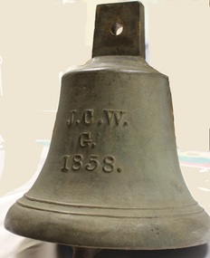
Functional object - Gordon Family Orchard Bell
The Gordons were architects and were associated with many buildings still standing in Albury and Wodonga, St Patrick's Church and the de Kerilleau Homestead among them. They established Vermont Orchard on 74 acres to the south of the Wodonga settlement. Here they grew fruit and nuts for the domestic and export market. The enterprising family also set about transforming some of the land by clearing it, creating streets and making general improvements. It was the biggest subdivision in Wodonga at the time. The 234 allotments in the Wodonga Estate were put up for sale by auction in May 1890. A total of 200 people were said to have attended. Gordon, William, Charles and Vermont streets in Wodonga are named after the family. This bell was used at the Vermont orchard to signal the beginning and end of the working day, as well as lunch breaks.The Gordon Family orchard bell is made of cast iron. It includes the inscription "J. C. W../G./1858." This is thought to represent the initials of John Gordon and sons Walter Joseph and Charles Goodwin Sylvester Gordon. There is some conjecture about this due to the date "1858". John was born in London, England in 1823 and died in 1880. Walter is generally accepted to have been born in 1857 and died 1903. In one family tree Charles is recorded as being born on 28 January 1858 but his birth was registered in 1860. The mystery of the date is therefore not fully resolved.On one side of the bell "J. C. W../G./1858."gordon family wodonga, gordon and gordon architects, vermont wodonga -
 Tarnagulla History Archive
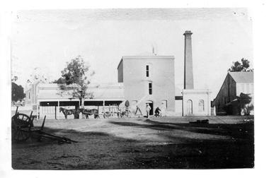
Photograph of Flour Mill complex, Tarnagulla, Flour Mill complex, Tarnagulla, circa 1882-1920
Murray Comrie Collection. Information written by Murray Comrie: A meeting was called at the Golden Age Hotel on 11th June 1868 when it was resolved to build a flour mill. Thomas Comrie was the proprietor and was responsible for the Mill being built. Tenders were called by H.C. Bristol, in the Tarnagulla Courier of January 10, 1874, for the erection of the mill. Building of the Mill commenced in 1874. Pipes were laid to Company's Dam to obtain water for the Mill's boilers. Steam was got up for the first time on 30th March, 1882. A boiler burst about April 29th. Two men (J.H. Smith and W. Hargreaves) died as a result and two others were seriously injured. The mill commenced operations on 13th June 1882 with Mr. W. Fitzgerald as manager. The Mill operated with grinding stones until 1899 when new rollers and a considerable amount of new equipment was installed, including a new, more powerful engine to drive the Mill. In January 1901, 6,000 bags of wheat were received weekly and it was a common sight to see the streets lined with wagons. In 1913, 15,000 bags of wheat were bought at three shillings and four pence per bushell. In January 1914, wheat came in at the rate of 1500 bags a day with 20,000 bags in storage. Thomas Comrie died on 4th August 1910. The Mill was carried on by his executors, then closed for a short period prior to being sold in September 1918 to a Mr. O. Albert of Talbot. Albert operated the Mill for a few years but during the 1920s it was closed down and then pulled down. It was later re-erected at Mildura where it operated for many years. The far left section of the complex was originally John Pierce's Southern Cross General Store, a wholesale grocer and spirit merchant. It was put up for sale after Pierce's death in 1871, and later incorporated into the Mill complex. This is a poor copy of an older original. Copy probably made by Murray Comrie in the 1960s. Monochrome photograph of men, horses and a wagon outside the Flour Mill complex formerly situated on the south east corner of King Street and Commercial Road in Tarnagulla. At far left the Methodist church is partially visible in the background. At far right is part of the Mill's storage shed. Same image as THA-2019.0211Written on reverse: 'M. Comrie'tarnagulla, commerce, agriculture, food production, mill, milling, horses, transport, buildings, commercial road, main street -
 Tarnagulla History Archive
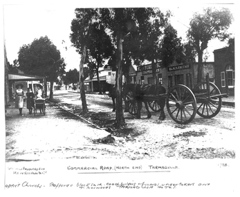
Photograph of the north end of Commercial Road, Tarnagulla, North end of Commercial Road, Tarnagulla, c. 1909
... norwood mcnamee buildings hotels churches commercial road main ...Murray Comrie Collection. This photograph shows business on the north end of Commercial Road, Tarnagulla. From right: the brick Baptist Church (now private residence), Stafford's Blacksmith Coachbuilders and funeral/undertakers (since demolished), & Norwood's Tarnagulla Hotel. Information collated by Murray Comrie: Stafford's premises were built on land previously occupied by the stables of the George Hotel. The Stafford's building was later taken over and run by Frank McNamee. This photograph is a dark copy created from an older original. Copy probably made by Murray Comrie in the 1970s. Monochrome photograph depicting the north end of Commercial Road, Tarnagulla. A large wagon with team of horses is standing in the road. Three girls are walking down footpath at left side of image.Written on the original: 'Specially produced for Renshaw & Co' and 'Commercial Road (North End) Tarnagulla'. Written on this copy: 'Baptist Church Staffords Blacksmith Coachbuilders and funeral/undertakers, & Norwood's Tarnagulla Hotel'.tarnagulla, commerce, industry, blacksmithing, smithing, coachbuilding, businesses, stafford, norwood, mcnamee, buildings, hotels, churches, commercial road, main street -
 Whitehorse Historical Society Inc.
Document, Colombo Street Buildings, 1/06/2004 12:00:00 AM
Detailed plans and drawings of proposed multi-storey buildings for Colombo Street, Mitcham.Detailed plans and drawings of proposed multi-storey buildings for Colombo Street, Mitcham. Also includes photos of Mitcham area around the buildings.Detailed plans and drawings of proposed multi-storey buildings for Colombo Street, Mitcham.colombo street, mitcham, mitcham, whitehorse road, mitcham, mitcham railway station, st johns catholic church, mitcham, station street, mitcham, high rise buildings -
Whitehorse Historical Society Inc.
Document, Vermont in the early days, 1/03/2003 12:00:00 AM
Recollections of Vermont by Frances Warren. Descriptions of shops and other buildings.Recollections of Vermont by Frances Warren. Descriptions of shops and other buildings.Recollections of Vermont by Frances Warren. Descriptions of shops and other buildings.vermont, vermont store, barnard family, wigg family, st lukes anglican church, vermont, wallace, wilbur, harrington family, jennings family -
Whitehorse Historical Society Inc.
Document, Whitehorse Heritage Review 2001, 2003
... of Whitehorse Heritage studies Houses Churches Historic Buildings Part 2 ...Part 2 : assessment of precincts. Contract No 02048. Project report, includes 'Proposed heritage overlay plans'.Part 2 : assessment of precincts. Contract No 02048. Project report, includes 'Proposed heritage overlay plans'.Part 2 : assessment of precincts. Contract No 02048. Project report, includes 'Proposed heritage overlay plans'.city of whitehorse, heritage studies, houses, churches, historic buildings -
 Ballarat Heritage Services
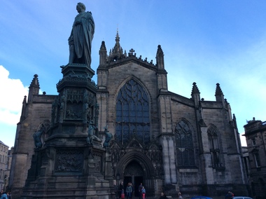
Digital Photograph, St Giles Cathedral, Edinburgh, Scotland, 10/2016
St Giles, also known as the High Kirk of Edinburgh is the principal place of worship for the Church of Scotland. It is very interesting for the mason's marks found on its many stone columns inside the church, and for its connections to the graveyard outside. According to wikipedia, "There is record evidence of a church here, very likely on the present site, in the year 854. In 1120 King Alexander I, rebuilt the church in the Norman style. Of this building characteristic features survived until 1798. During the fourteenth century, Edinburgh was captured and plundered by the English under Edward II. and Edward III., and twice St Giles was laid waste. After restoration, the church was more thoroughly ruined at the Burnt Candlemas in 1387, when Richard II. sacked the city. The western part of the fabric was soon in use again ; but the restoration of the choir and transepts, which were much enlarged, lasted on into the sixteenth century. In 1467 the city endowed St Giles as a collegiate church. It now became usual to speak of the nave, where the stonework was ancient, as the Old Kirk, while the eastern part of the building was called the New Kirk. When the movement for reform drew large crowds to St Giles, separate services began to be regularly held in the Old and New Kirks. Soon this was not enough, and the great church was partitioned off into smaller sections. In 1571 St Giles was seized by Kirkcaldie of Grange, and held by him as a stronghold for Queen Mary. This resulted in serious damage to the structure.Colour photograph of St Giles Cathedral, Edinburgh, Scotlandst giles cathedral, edinburgh, scotland, architecture -
 Ballarat Heritage Services
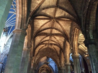
Digital Photograph, Dorothy Wickham, Interior, St Giles Cathedral, Edinburgh, Scotland, 10/2016
St Giles, also known as the High Kirk of Edinburgh is the principal place of worship for the Church of Scotland. It is very interesting for the mason's marks found on its many stone columns inside the church, and for its connections to the graveyard outside. According to wikipedia, "There is record evidence of a church here, very likely on the present site, in the year 854. In 1120 King Alexander I, rebuilt the church in the Norman style. Of this building characteristic features survived until 1798. During the fourteenth century, Edinburgh was captured and plundered by the English under Edward II. and Edward III., and twice St Giles was laid waste. After restoration, the church was more thoroughly ruined at the Burnt Candlemas in 1387, when Richard II. sacked the city. The western part of the fabric was soon in use again ; but the restoration of the choir and transepts, which were much enlarged, lasted on into the sixteenth century. In 1467 the city endowed St Giles as a collegiate church. It now became usual to speak of the nave, where the stonework was ancient, as the Old Kirk, while the eastern part of the building was called the New Kirk. When the movement for reform drew large crowds to St Giles, separate services began to be regularly held in the Old and New Kirks. Soon this was not enough, and the great church was partitioned off into smaller sections. In 1571 St Giles was seized by Kirkcaldie of Grange, and held by him as a stronghold for Queen Mary. This resulted in serious damage to the structure.Two colour photographs of the interior if St Giles Cathedral, Edinburgh, Scotlandst giles cathedral, architecture, mason's marks, stonemasons, church of scotland -
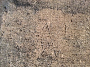 Ballarat Heritage Services
Digital Photograph, Stonemason's marks, St Giles Cathedral, Edinburgh, Scotland, 10/2016
St Giles, also known as the High Kirk of Edinburgh is the principal place of worship for the Church of Scotland. It is very interesting for the mason's marks found on its many stone columns inside the church, and for its connections to the graveyard outside. According to wikipedia, "There is record evidence of a church here, very likely on the present site, in the year 854. In 1120 King Alexander I, rebuilt the church in the Norman style. Of this building characteristic features survived until 1798. During the fourteenth century, Edinburgh was captured and plundered by the English under Edward II. and Edward III., and twice St Giles was laid waste. After restoration, the church was more thoroughly ruined at the Burnt Candlemas in 1387, when Richard II. sacked the city. The western part of the fabric was soon in use again ; but the restoration of the choir and transepts, which were much enlarged, lasted on into the sixteenth century. In 1467 the city endowed St Giles as a collegiate church. It now became usual to speak of the nave, where the stonework was ancient, as the Old Kirk, while the eastern part of the building was called the New Kirk. When the movement for reform drew large crowds to St Giles, separate services began to be regularly held in the Old and New Kirks. Soon this was not enough, and the great church was partitioned off into smaller sections. In 1571 St Giles was seized by Kirkcaldie of Grange, and held by him as a stronghold for Queen Mary. This resulted in serious damage to the structure.Colour photographs of tonemason's marks, St Giles Cathedral, Edinburgh, Scotlandmason's marks, st giles cathedral -
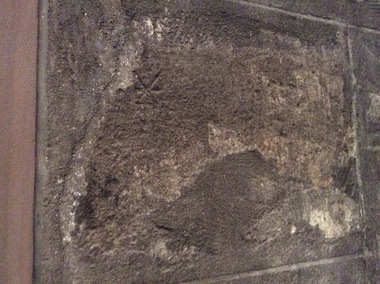 Ballarat Heritage Services
Photograph - Digital Photograph, Stonemason's marks, St Giles Cathedral, Edinburgh, Scotland, 10/2016
St Giles, also known as the High Kirk of Edinburgh is the principal place of worship for the Church of Scotland. It is very interesting for the mason's marks found on its many stone columns inside the church, and for its connections to the graveyard outside. According to wikipedia, "There is record evidence of a church here, very likely on the present site, in the year 854. In 1120 King Alexander I, rebuilt the church in the Norman style. Of this building characteristic features survived until 1798. During the fourteenth century, Edinburgh was captured and plundered by the English under Edward II. and Edward III., and twice St Giles was laid waste. After restoration, the church was more thoroughly ruined at the Burnt Candlemas in 1387, when Richard II. sacked the city. The western part of the fabric was soon in use again ; but the restoration of the choir and transepts, which were much enlarged, lasted on into the sixteenth century. In 1467 the city endowed St Giles as a collegiate church. It now became usual to speak of the nave, where the stonework was ancient, as the Old Kirk, while the eastern part of the building was called the New Kirk. When the movement for reform drew large crowds to St Giles, separate services began to be regularly held in the Old and New Kirks. Soon this was not enough, and the great church was partitioned off into smaller sections. In 1571 St Giles was seized by Kirkcaldie of Grange, and held by him as a stronghold for Queen Mary. This resulted in serious damage to the structure.Three photographs of stonemason's marks, St Giles Cathedral, Edinburgh, Scotlandmason's marks, st giles cathedral -
 Ballarat Heritage Services
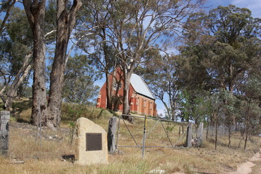
Photograph - Photograph - Colour, Clare Gervasoni, Former Franklinford Church, 2015, 25/10/2015
Franlinford is associated with the Mt Franklin Aboriginal Protectorate. Photograph of a brick building - the former Mt Franklin Church, and associated plaque.franklinford, religion, church, e.s. parker -
 Ballarat Heritage Services
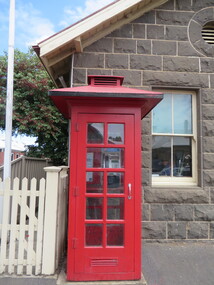
Photograph - Photograph - Colour, Clare Gervasoni, Koroit Post Office, 2015, 21/12/2015
The town borrows its name from the Koroitch Gundidj people who occupied the area prior to European settlement. (https://en.wikipedia.org/wiki/Koroit, accessed 21 December 2016) Koroit was first surveyed as a township in 1847. Around the 1850 the district had the highest population of Irish immigrants in rural Australia. The Koroit Post Office was designed by architect and engineer John Mason of Port Fairy. (Moyne Shire Heritage Study 2006 Stage 2, Volume 2: Environmental History, Prepared for Moyne Shire Council Helen Doyle in association with Context Pty Ltd, 2006.) Rosebrook Bridge, Rosebrook (1853; replaced) Post Office buildings, Bank Street, Port Fairy (c.1857) The author Henry Handel Richardson lived in the Koroit Post Office as a child after her family moved to Koroit in 1878. Remembering Koroit from her youth, the third volume in her The Fortunes of Richard Mahony trilogy is set in the town. When the author was six, her father Walter died in Koroit on 1 August 1879 and was buried at the Koroit cemetery. (https://en.wikipedia.org/wiki/Koroit, accessed 21 December 2016) In 1878 Mary Richardson was appointed postmistress of the Koroit Post Office at a salary of 72 pounds with free quarters, firewood and kerosene. She lived at the back of the Post Office. (From a Green and Pleasant Land by H. McCorkell and P. Yule.) Photographs showing the bluestone Koroit Post Office, phone box and postbox. It is located at 99 Commercial Road, Koroit. "Historic Area Statement of Significance: The significance of Koroit derives from its role as the urban centre of one of the most concentrated Irish Roman Catholic rural districts in Australia, noted for its mixed livestock and cropping argicultural patterns. This is reflected in two separate and distinctive areas in the town - the administrative/commercial area and the church precinct. The administrative and commercial area (focussing on the Boundary-Commercial Road/High Street intersection and the Koroit Hotel) consists of a number of significant public buildings and leads to a street of relatively intact humble shopfronts and kerbline verandahs, visually punctuated by opposing bank facades. The church precinct is dominated by a group of Catholic buildings larger in scale and more complete in range than those in any comparably sized Victorian town." http://vhd.heritagecouncil.vic.gov.au/places/69338#sthash.ELLuSMvg.dpuf, accessed 21 December 2016."koroit, post office, phone box, payphone, bluestone, henry handel richardson, koroit post office -
 Ballarat Heritage Services
Photograph - Digital Photograph, Leicester Guildhall
The Leicester Guildhall is adjacent to Leicester Cathedral where King Richard III has been reinterred. The interpretative centre nearby is situated upon the car park where his remains were uncovered. The Great Hall was built in 1390 and dates back to medieval days. It was a meeting place for the Guild of Corpus Christi, a select group of influential businessmen and gentry founded in 1343. The Guild had their own altar in the Church of St Martin (now Leicester Cathedral) and used the Great Hall for banquets. By 1563 the building was Leicester's Town Hall. guild hall -
 Ballarat Heritage Services
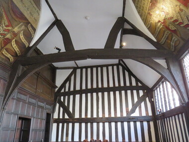
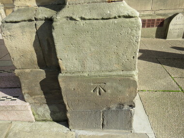
Digital Photograph, Stonemason mark, Ashbourne Town Hall, UK
Ashbourne is one of Derbyshire's fines and most vibrant market towns. It combines a wealth of historic buildings and shops. The Market Place is cobbles with hidden alleys and yards that lead to the carparks behind the main street. The wide and elegant Church Street is considered to be the finest street of Georgian buildings in Derbyshire. Tissington Hall and Village are in the nearby vicinity. Built by Francis Fitzherbert in 1609 Tissington Hall has been lived in by the Fitzherbert family ever since. The estate village has a number of micro businesses and a beautiful duck pond. Reference: Information from the Ashbourne Tourist pamphletmason marks ashbourne derbyshire market town francis fitzherbert tissington -
 Ballarat Heritage Services
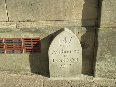
Digital Photograph, Milestone, Ashbourne, UK
Ashbourne is one of Derbyshire's fines and most vibrant market towns. It combines a wealth of historic buildings and shops. The Market Place is cobbles with hidden alleys and yards that lead to the carparks behind the main street. The wide and elegant Church Street is considered to be the finest street of Georgian buildings in Derbyshire. Tissington Hall and Village are in the nearby vicinity. Built by Francis Fitzherbert in 1609 Tissington Hall has been lived in by the Fitzherbert family ever since. The estate village has a number of micro businesses and a beautiful duck pond. Reference: Information from the Ashbourne Tourist pamphlet -
 Ballarat Heritage Services
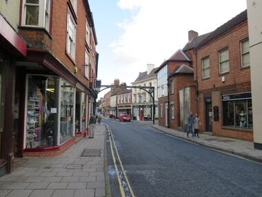
Digital photograph, Sign, Ashbourne, UK
Ashbourne is one of Derbyshire's fines and most vibrant market towns. It combines a wealth of historic buildings and shops. The Market Place is cobbles with hidden alleys and yards that lead to the carparks behind the main street. The wide and elegant Church Street is considered to be the finest street of Georgian buildings in Derbyshire. Tissington Hall and Village are in the nearby vicinity. Built by Francis Fitzherbert in 1609 Tissington Hall has been lived in by the Fitzherbert family ever since. The estate village has a number of micro businesses and a beautiful duck pond. Reference: Information from the Ashbourne Tourist pamphletGreen Man and Black's Head Royal Hotelashbourne derbyshire church st francis ftizherbert market town georgian tissington -
 Ballarat Heritage Services
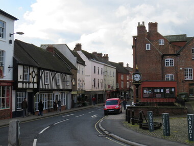
Digital Photograph, Ashbourne, UK
Ashbourne was the village of an historical event. At Ashbourne on 3 December 1745 Charles Edward Stuart declared his father James King of England, Wales and Scotland. Ashbourne is one of Derbyshire's fines and most vibrant market towns. It combines a wealth of historic buildings and shops. The Market Place is cobbles with hidden alleys and yards that lead to the carparks behind the main street. The wide and elegant Church Street is considered to be the finest street of Georgian buildings in Derbyshire. Tissington Hall and Village are in the nearby vicinity. Built by Francis Fitzherbert in 1609 Tissington Hall has been lived in by the Fitzherbert family ever since. The estate village has a number of micro businesses and a beautiful duck pond. Reference: Information from the Ashbourne Tourist pamphlet -
 Ballarat Heritage Services
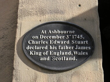
Digital Photograph, Plaque, Ashbourne, UK
Ashbourne is one of Derbyshire's fines and most vibrant market towns. It combines a wealth of historic buildings and shops. The Market Place is cobbles with hidden alleys and yards that lead to the carparks behind the main street. The wide and elegant Church Street is considered to be the finest street of Georgian buildings in Derbyshire. Tissington Hall and Village are in the nearby vicinity. Built by Francis Fitzherbert in 1609 Tissington Hall has been lived in by the Fitzherbert family ever since. The estate village has a number of micro businesses and a beautiful duck pond. Reference: Information from the Ashbourne Tourist pamphletAt Ashbourne on December 3rd 1745, Charles Edward Stuart declared his father James King of England, Wales and Scotland.king james, ashbourne -
 City of Ballarat Libraries
Photograph - Card Box Photographs, Wesley Church, School of Mines and Court House, Ballarat circa 1900
... Court House Buildings Streetscape Church Public ...These buildings were located on Lydiard Street South. The court house was relocated to Camp Street.wesley church, school of mines, ballarat court house, buildings, streetscape, church, public -
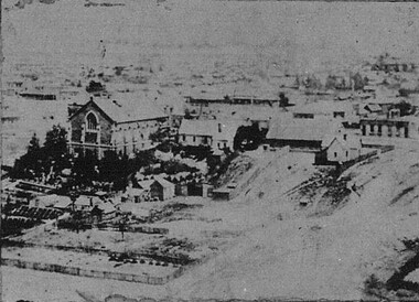
 City of Ballarat Libraries
Photograph - Card Box Photographs, Second St Andrew's Kirk, Ballarat circa 1860
... Station Building Sturt Street Church ...Photograph taken from Ballarat City Fire Station tower. st andrew's kirk, ballarat city fire station, building, sturt street, church -
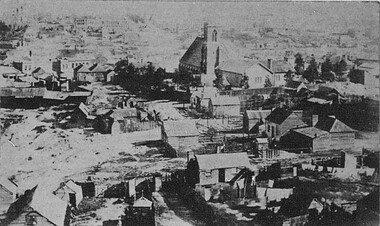
 City of Ballarat Libraries
Photograph - Card Box Photographs, Wesley Church, Ballarat circa 1870
... Building Garden Church ...Photograph was taken from the Ballarat Gas Company chimney to the west. In the foreground might be R.U. Nicholls Nursery.wesley church, r.u. nicholls nursery, building, garden, church -
 City of Ballarat Libraries
Photograph - Card Box Photographs, View from the tower East Ballarat Fire Tower towards the west circa 1862
... Fire Station Church Building Private Dwelling ...St Paul's Church can be clearly seen.st paul's church, east ballarat fire station, church, building, private dwelling -
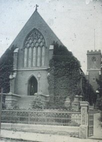 City of Ballarat Libraries
Photograph - Card Box Photographs, St Paul's Church, Bakery Hill 1958
... Street South. St Paul's Church Humffray Street South Building ...St Paul's Church is located in Humffray Street South.st paul's church, humffray street south, building -
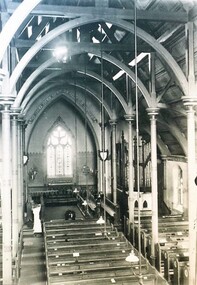 City of Ballarat Libraries
Photograph - Card Box Photographs, Interior of St Paul's Church, Bakery Hill 1958
... in Humffray Street South. St Paul's Church Building ...The church is located in Humffray Street South.st paul's church, building -
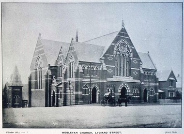 City of Ballarat Libraries
Postcard - Card Box Photographs, Wesleyan Church, Lydiard Street
... Ballarat Lydiard Street South Building Church ...Plate 10. Black Photo.wesley church, ballarat, lydiard street south, building, church -
 City of Ballarat Libraries
Postcard - Card Box Photographs, St Peter's Anglican Church, Sturt Street
... Peter's Church Sturt Street Building Church Public ...Plate 30, Chuck Photo series.st peter's church, sturt street, building, church, public -
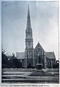 City of Ballarat Libraries
Postcard - Card Box Photographs, St Andrew's Presbyterian Church, Sturt Street
... Sturt Street Peter Lalor Building Statue Public Church ...The statue in the foreground is of Peter Lalor. Plate 31 Black Photo series.st andrew's church, sturt street, peter lalor, building, statue, public, church