Showing 10954 items matching "land "
-
 Bacchus Marsh & District Historical Society
Map, Plan of Survey of Part of Crown Allotment 9, Parish of Korkuperrimul, 1890
This map documents a transfer of an allotment of land in Clarke Street Bacchus Marsh in 1890. Clarke Street is located on the eastern side of Bacchus Marsh not far from Main Street and Crook Street. It is now known as Candeloro Street. The map indicates J. Booth as the owner of the land and H. Simpson as the occupier. Next to this allotment is a an allotment of land owned by J. Elmore,Single page map showing Crown allotment 9, Parish of Korkuperrimul, County of Bourke. Scale 100 feet to inch. Part of a set of maps which are pasted into a bound volume containing 76 maps or plans in total. High resolution digital image stored on BMDHS computer network. At bottom of map: I hereby certify that I have made this survey expressly for the purpose of an application under the Transfer of Land Statute that this plan is correct. Barry B???, Lic. Surveyor, 16.10.90bacchus marsh victoria maps, clarke street bacchus marsh maps -
 Whitehorse Historical Society Inc.
Document, You too can wander, 1985
The land of the Woiworung.The land of the Woiworung.The land of the Woiworung.woiworung aboriginal tribe, aborigines, aboriginal artefacts -
 Federation University Historical Collection
Accessory - Bookmark, Adam And Charles Black, The English Lakes and Religious Bookmark, 1949
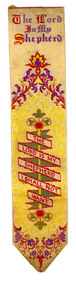
This bookmark was found in a book called 'The English Lakes' owned by Elizabeth Chatham-Holmes. The bookmark is a Stevenograph. In 1854 Thomas Stevens began with weaving plain and fancy ribbons, but was soon experimenting with a development of jacquard weaving to produce pictures. For this, the picture was plotted on squared paper, in the fashion of a cross-stitch embroidery design, and a large card then perforated to represent each colour appearing in every "line" of the picture. The cards, arranged in an endless chain and attached to the loom, controlled the manipulation of the warp threads. Each time the shuttle crossed the loom a different card came into use, changing the arrangement of the warp threads and, consequently, the pattern woven..When the industry collapsed in 1860, Stevens determined to make use of his experiments by producing pictures in such variety as to appeal to all tastes. The earliest productions seem to have been bookmarkers... The pictures included portraits of celebrities and local scenes, scriptural texts, hymns and psalms, and verses from the poets. Stevens also introduced to the Admiralty a hat ribbon with the name of the ship woven in gold wire. This he patented; it was adopted and for many years the firm was the sole supplier to the Admiralty Contracts Department. https://stevengraphs.com/thomstevandh.html Also found in the book was a small card with dried flowers glued with the words 'Flowers from the Holy Land' and a WW2 photograph of the bust of a man in uniform with a cap..1) Red hard covered book called 'The English Lakes' by W.T. Palmer. .2) Woven silk bookmark with white (now cream) and yellow background and red, purple, green and yellow detail and the start of Psalm 23 woven into the bookmark. Possibly made in the late nineteenth century. .3) Small card with dried flowers glued with the words Flowers from the Holy Land .4) WW2 photograph of the bust of a man in uniform with a cap. .1) Inside front cover "E.S. Holmes Ascot" .2) Woven into the bookmark - The Lord is my Shepard I shall not want, & T. Stevens, Coventry .3) Printed on the front - Flowers from the Holy Land, Placed on the Holy Sepulchreholmes, ec holmes, ascot, religious, religion, bookmark, english lakes, w.t. palmer, chatham-holmes collection, flowers from the the holy land, stevengraph -
Lakes Entrance Historical Society
Book, Morrissey D W and Morrissey E W, Lakes Entrance a Short History and Tourist Guide
A short history of lakes Entrance from early settlement, including references to forest survey, land sales, shipping, fishing industry and development of the town and tourist industry A short history of lakes Entrance from early settlement, including references to forest survey, land sales, shipping, fishing industry and development of the town and tourist industrysettlers, land settlement -
 Surrey Hills Historical Society Collection
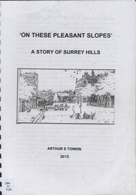
Book, On these pleasant slope's: a story of Surrey Hills, 2015
Sourced via conversations with those interested in Surrey Hills History. Including Alan Holt, Jack McLean, Frank Bamford, Jocelyn Hall. Includes: Topographical maps, first Elgar Survey. First Wesleyan Church in Surrey Hills. Bibliography on P.50 (last numbered page) Provides a chronological history of Surrey Hills. Includes: First settlers, location, early land sales, commerce and trade.Provides a chronological history of Surrey Hills. Includes: First settlers, location, early land sales, commerce and trade.Back of Title page: To the Surrey Hills Historical / Arthur E. Tonkinfreehold investment and banking company, windsor park estate, (mr) dennis delany, mont albert village, surrey hills - history, royal hotel, surrey hills, humberstone's hotel, chatham state school, holy trinity church, lydswood, lugano, (mr) john butler maling, (mr) john hanlon knipe, mont albert primary school, (mr) james sneddon, (mr) arthur tonkin -
Port Melbourne Historical & Preservation Society
Document - Transfer of land, Graham Street, Port Melbourne, 5 Feb 1872
Application by Henry Gale under Transfer of land statute re land in Graham Streettown planning, henry gale, land sales -
Lakes Entrance Historical Society
Book, McDonald, Geoff, Red Over Black, 1982
Behind the Aboriginal Land Rights - account of the Communist Party influence on Aboriginal Land Rights.ISBN 0949667501aboriginals -
 Bendigo Historical Society Inc.
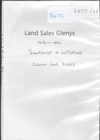
Archive - LAND SALES 1854-1882, 1854-1882
DVD. Land sales Glenys 1854-1882. Sandhurst and Outlaying. Crown land sales. -
 Linton and District Historical Society Inc
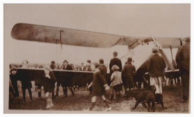
Photograph, Aeroplane Landing at Linton Park, 1928, 1928
Picture in photograph album donated by Mrs Faull. The plane landed at Linton Park as part of an advertising campaign by Astor Radios in 1928. Information provided by Ron Preston of Linton: "The day the plane landed in Linton Park / late 20s. Fairbanks and Harrison operated a garage in Sussex St opposite Bryant's shop. Fairbanks was married to Carrie Murrell's sister Dorrie and William (Bill) Harrison was married to Dulcie Nicol. Among other things that the garage sold were ASTOR RADIOS. To promote ASTOR RADIO a Gypsy Moth double seater aircraft flew low over towns to advertise. ASTOR RADIO was written under both wings. by Boltes) staying overnight. Both Harrison & Fairbanks were taken up for a ride. The pilot "dive-bombed" the local children, many of them seeking shelter under the bridge, as they were frightened, not having seen a plane up close before." Sepia photograph of a biplane surrounded by a crowd of people. One of three photographs of this occasion, the others are Registration nos. 627.1 & 627.2"1st aeroplane to land in Linton 1928". events, faull collection, aeroplanes, linton park -
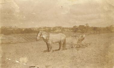 Ringwood and District Historical Society
Photograph, 'Quambee', North Ringwood - 1912
Sepia photograph showing man on horse drawn plough.Written on back of photograph: "Quambee land." -
Linton and District Historical Society Inc
Certificate of Title, Certificate of Title : Crown Allotments 27, 28, 29, 30, Section 4, Township of Linton
The land was transferred to Theophilus William Nelson and James Adolphus Nelson in 1929. James and Theo Nelson later (1955) acquired Allotment 36, Section 4 which adjoins these allotmentsCopy of Certificate of Title for several adjacent blocks of land on the corner of Clyde Street and Grantley Street in Linton. Copy is comprised of photostat sheets held together by tape.theophilus william nelson, james adolphus nelson, certificates of title, allotments 27 - 30 township of linton -
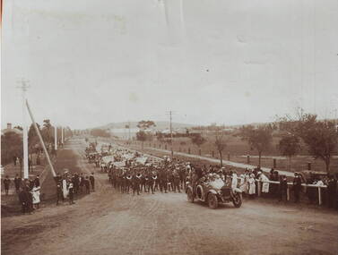 Sunbury Family History and Heritage Society Inc.
Photograph, A parade
The parade took place in Sunbury in 1919 and was held to welcome home the local returned soldiers, who had enlisted in World War 1. In the photograph the parade is approaching the intersection at Evans and Macedon Streets. Sunbury's Shopping complex now occupies the vacant land in the background, although for many years that land was the main sports ground. The building in the distance was the Sunbury Fire Brigade.Many Sunbury men enlisted to fight in World War 1. Sadly some did not return home but others did.A copy of a non-digital sepia photograph of a parade being led along a road by a vintage car. There is open land with a few buildings in the distance. Spectators are watching the parade on either side of the roadway.evans street, macedon street, world war 1., parades, welcome home receptions -
Whitehorse Historical Society Inc.
Article, Historic building reduced to rubble, 1988
An old homestead which belonged to the Mullens family for 5 generations.An old homestead which belonged to the Mullens family for 5 generations has been demolished by the Board of Works who now own the land. the Board demolished the house because it was a fire hazard.An old homestead which belonged to the Mullens family for 5 generations.burwood highway, vermont south, springvale road, vermont south, mullens, hugh, mullens, mary, mullens, elma, ellerton, andrew, tate, sherryn, melbourne and metropolitan board of works -
 Kiewa Valley Historical Society
Maps - Tawonga and Feathertop
Plan of Tawonga showing roads etc, rivers, use of land in 1968 and of Feathertop in 1969.Historical use of land in Tawonga and Feathertop.1. Topographical Map - Tawonga 803 Forests Commission of Victoria 1968. Cream paper with black print. Legend: Roads, tracks etc, rivers, Parishes and use of land. 2. Feathertop 813. 1969tawonga map 1968, tawonga parishes, feathertop map 1969 -
Whitehorse Historical Society Inc.
Document, Charles Edgerton, 1851 - 1908
Life history of Charles Edgerton.Life history of Charles Edgerton who purchased land in Edgerton Road, Mitcham from Carl Benno Schwerkolt in 1892 and an account of the 1905 bushfire in the area. Prepared by Anne Jones.Life history of Charles Edgerton.edgerton, charles, schwerkolt, carl benno, edgerton road, mitcham, jones, anne -
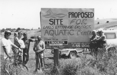 Lakes Entrance Historical Society
Photograph - Aquatic Centre, Lakes Post Newspaper, 1993
also one black and white photograph empty paddock with sign for proposed aquatic centre, with Council Offices at top of hill number in album 03515.02Black and white photograph taken at site of proposed aquatic centre Palmers Road, group of people beside prominent sign, Clark Warnock, Russell Smith with Kendra, Chris Newton, Ian McDougall, Lester Gedgin and Terry Barling. Lakes Entrance Victoriarecreational facilities, land -
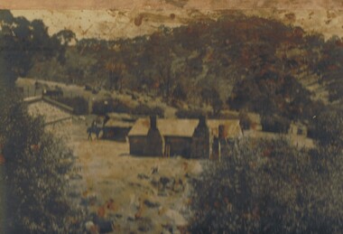 Bendigo Historical Society Inc.
Photograph - THE SPRINGS, SEDGWICK
Photograph - black and white. Photograph of 'The Springs, Sedgwick', 14 miles from Bendigo. Rocky, hilly landscape with scattered trees, two chimneys on the main building in the centre, horse and rider approaching the building. Also 3 current photographs taken by Phillip Wilkin on July,2009. The 3 current photo's showing bluestone ruins - it is the same building on the left of the old photo - not the building with 2 chimney's, the one hidden behind trees (you only see part of it). Phillip's grandfather (Charles Wirth) moved here in 1901, along with his parents and grew up in that building (now ruined), the family still own the land.place, land, the springs, sedgewick., the springs, sedgwick. -
 Greensborough Historical Society
Folder of documents, Nepean Street - fact or fiction?, by Peter Simmenauer, 2018_09
Record of ownership of 216 Nepean Street Greensborough 1916-1997, Grace Park areaPhotocopies of four Certificates of Title and other land documents, with summary of land ownership 1916-1997nepean street greensborough, grace park -
 Bendigo Historical Society Inc.
Photograph - NORM GILLIES COLLECTION: SITE OF GILLIES FAMILY FARM
Coloured photograph of open farm land rear note: Gillies Family farmed land on this property -
Whitehorse Historical Society Inc.
Article, Death of 'Strathdon' donor, 19/05/1971 12:00:00 AM
Article in Nunawading Gazette 19 may 1971.Article in Nunawading Gazette 19 may 1971 on the death of Mrs Mary Matheson who helped in the foundation of Blackburn, Vermont and Mitcham Presbyterian churches and donated the land for the Strathdon Homes for the Aged.Article in Nunawading Gazette 19 may 1971. matheson, mary, strathdon community, blackburn presbyterian church, vermont presbyterian church, mitcham presbyterian church -
 Bacchus Marsh & District Historical Society
Map, Bacchus Marsh Suburban Allotments Parwan Road Lodge & Dunn's Paddocks 1888
This map was created as a plan for an auction of land close to the Bacchus Marsh Railway Station. The auction took place on 23 October 1888. 102 allotments of land from an area known as Lodge and Dunn's paddocks was offered for sale. A single page paper map showing allotments of land for sale along the Parwan Road in Maddingley. The map is pasted into a bound volume containing 76 maps or plans in total. High resolution digital image stored on BMDHS computer network. land sales bacchus marsh, land sales maddingley, bacchus marsh victoria maps, maddingley victoria maps -
Beechworth Honey Archive
Hand-Written copy of Transfer of Land April 1919
Two pages included in this item. First Page: Hand-written copy of Transfer of Land. Frost (of Meldrum St, Wangaratta) to Pauline Louise Hills. £195.0.0 Parish of Mordialloc, County of Burke. Dated April 7th 1919 Second Page: Notes about agents fees. Both written with black ink on paper.hand written, hand-written, transfer, land, frost, hills, mordialloc, burke, beekeeper, beechworth honey -
 Hume City Civic Collection
Photograph, c late 1980s
The series of photographs show a number of sites included in the Rupertswood Estate. By 1851 William Clarke had acquired 31,375 acres of land in the Sunbury district. The foundation stone for Rupertswood Mansion was laid on 29th August 1874 by Mrs. W. J. Clarke, daughter-in-law of 'Big Bull'. The Salesian Fathers bought the Rupertswood property in June 1927 and established Salesian College.A coloured photograph of an open valley with scrub which is part of the original Rupertswood Estate. This land is north of the mansion and existing Salesian College.rupertswood estate, clarke, william j. t. 'big bull', salesian brothers, george evans collection -
Clunes Museum
Document - LEASE
LICENCE ISSUED TO MR. PATRICK KEIRCE [INCORRECT SPELLING KIERCE] ON 29TH AUGUST 1870PHOTOCOPY OF LEASE OF LANDASSISTANT COMMISSIONER OF LANDS AND SURVEY. BALLARAT.local history, document, lease, kierce, michael mr. -
 Clayton RSL Sub Branch
Photograph, Reinforcements from 7/37 Battalion
HMAT Ballarat was torpedoed by a German submarine in the english channel. All 1720 souls on board survived the torpedo attack. HMAT Ballart departed from Melbourne on 19.2.1917.photo of troops on landReinf 7/37 Batt. A.I.F Torpedoed on HMAT Ballarat on Anzac Day 25th April 1917 These troops when torpedoed upheld the best traditions of the race and their conduct was beyond praise. They were the recipients of the warmest praise from his Majesty the King; General Birdwood K.S.C.I. KCMG. CB. CIE, DSO. and the Commonwealth High Commissioner, The Hon Andrew Fisher. -
Whitehorse Historical Society Inc.
Document, Course family, 2008
The Course Family - pioneers of Forest Hill. Talk given by Pat Richardson at a Whitehorse Historical Society general meeting, 9 February 2008.The Course Family - pioneers of Forest Hill. Talk given by Pat Richardson at a Whitehorse Historical Society general meeting, 9 February 2008. With genealogical chart and documents relating to the family's English origins, migration and land holdings.The Course Family - pioneers of Forest Hill. Talk given by Pat Richardson at a Whitehorse Historical Society general meeting, 9 February 2008. forest hill, tainton family, fankhauser family, whitehorse historical society inc., course family -
 Bacchus Marsh & District Historical Society
Map, Plan of the second portion of the property of Messers Atkins and Clarke situate at Bacchus Marsh 1856
This plan of land allotments for sale indicates part of the property once owned by the Bacchus family in and around the township area of Bacchus Marsh. The Bacchus family sold their property in Bacchus Marsh to John Aitkins and Robert Nalder Clarke in March 1851. Aitkins and Clarke kept the property for a number of years until April 1856 when these allotments were put up for sale.This is a very early land sales plan for agricultural land close to the township of Bacchus Marsh. It therefore provides some clues as to how the early urban development of the township and agricultural development of the nearby area took place. Upon seeing the map in 1911 Bacchus Marsh Express newspaper editor Christopher Crisp wrote "The sale appears to have created the present township, which had a nucleus in earlier times further east", Express, 30 September, 1911, page 3.A single page paper plan showing allotments of land for sale. The subdivided land shown was owned by John Aitkins and Robert Nalder Clarke, but previously owned by the Bacchus Family and was in and around their Manor House (Mansion) property in Bacchus Marsh. This plan shows allotments in the second portion of land to be sold which was located east of the Manor House on the eastern side of the Lerderderg River. The land for sale was made up of 15 allotments. The plan is pasted into a bound volume containing 76 maps or plans in total. BMDHS Loc: AR/B12/S4 Bacchus Marsh Township and Nearby Districts Maps Volume In-house Digital copies: BMDHS, Computer Network: Maps\Bacchus Marsh Township and Nearby Districts Maps Volumebacchus marsh victoria maps, bacchus family, land sales, manor house bacchus marsh -
Whitehorse Historical Society Inc.
Article, Rezoning outrage, 22/09/1992 12:00:00 AM
Nunawading Council outraged by State Government's shock decision to immediately rezone land in the Eastern Arterial Road corridor without public consultation.Nunawading Council outraged by State Government's shock decision to immediately rezone land in the Eastern Arterial Road corridor without public consultation. The decision means the land set aside for the Eastern Arterial Road will be immediately rezoned to public open space by ministerial amendment jeopardising any future moves to construct the entire freeway. Council are considering Supreme Court action to stop the rezoning.Nunawading Council outraged by State Government's shock decision to immediately rezone land in the Eastern Arterial Road corridor without public consultation. local government, city of nunawading, eastern freeway, koonung mullum forestway association, mullum mullum creek -
 Bacchus Marsh & District Historical Society
Map, Coimadai Parish Map, County of Bourke. Circa 1890s-1900s
The cadastral Parish of Coimadai, a subdivision of the County of Bourke, lies directly north of the township of Bacchus Marsh. The date of this map is uncertain. T.F. McGauran the person who made a photo-lithographic copy of the map was in charge of photo-lithography at the Victorian Department of Lands and Survey in the late 19th century until about 1910.A single page paper map showing the map for the Parish of Coimadai in the County of Bourke. A cadastral map showing parish boundaries and land ownership. A rectangle shaped area is missing from the centre of the map due to a tear or deliberate excision. The map is pasted into a bound volume containing 76 maps or plans in total. High resolution digital image stored on BMDHS computer network. Photo-lithographed at the Department of Lands and Survey, Melbourne by T.F. McGauran 26.8.[??] NOTE. Photo litho from L.P showing temporary surveys and occupation of land prepared for departmental use onlybacchus marsh region parish plans, coimadai parish maps, coimadai parish plan -
Whitehorse Historical Society Inc.
Document, Details of Title Changes - 2 Gordon Crescent, Blackburn
Details of title changes of 2 Gordon Crescent, Blackburn.Details of title changes of 2 Gordon Crescent, Blackburn. Original owner of land was John Woods in 1855. He resold to George Coppin who resold to Freehold & Investment Banking Co. of Australia.Details of title changes of 2 Gordon Crescent, Blackburn. gordon crescent, blackburn, no. 2, woods, john, coppin, george seth, freehold investment and banking company of australia ltd, australian deposit and mortgage bank