Showing 11518 items matching "maps"
-
 Victorian Aboriginal Corporation for Languages
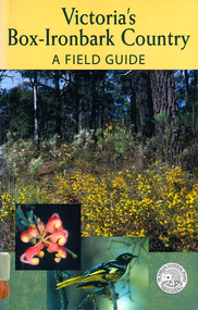
Book, Malcolm Calder et al, Victoria's box-ironbark country : a field guide, 2002
Gives thorough introduction to the dry-forest area and the plants and animals of that habitat.Maps, colour photographs, b&w illustrationsbox-ironbark forests, deforestation, sustainability, environment, biodiversity -
 Victorian Aboriginal Corporation for Languages
Book, Intechnics, Australian mammals : with Aboriginal perspectives and drawings
B&w illustrations, maps, word listseducation, australian fauna, monotremes, marsupials, mammals, primary school education, environmental education -
 Victorian Aboriginal Corporation for Languages
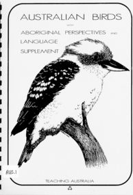
Book, Intechnics, Australian birds : with Aboriginal perspectives and language supplement
B&w illustrations, maps, word listsaustralian birds, education, primary school education, environmental education -
Port Melbourne Historical & Preservation Society
Card - Binder, Piers Festival, Polly Woodside Maritime Museum, c. 1990
These migrant ship cards were used loose by the former Maritime Museum (Polly Woodside), and donated to PMHPS by A Gibson, National Trust Victoria, bound in January 2013 for use in the PMHPS display on migrant ships in Princes Pier GatehouseOne of three sets of laminated information cards, punched and roughly bound into a book for information display at "Piers festival". (.01) - "Angelina Lauro" to "Esperance Bay" (.02) - "Fairsea" to "Moreton Bay" (.03) - "Northern Star" to "Stathmore"The backs of the cards are pasted with sections of nautical maps.transport - shipping, immigration, celebrations fetes and exhibitions, angelina lauro, arcadia, australis, canberra, captain cook, captain hobson, castel felice, chusan, dominion monarch, ellinis, esperance bay, fairsea, fairstar, fairsky, galileo galilei, himilaya, johan van olden barnevelt, largs bay, maasdam, mariposa, moreton bay, northern star, orion, oriana, oronsay, ormonde, orsova, otranto, patris, roma, southern cross, stathaird, statheden, stathmore, ss iberia, ss guglielmo marconi -
 Whitehorse Historical Society Inc.
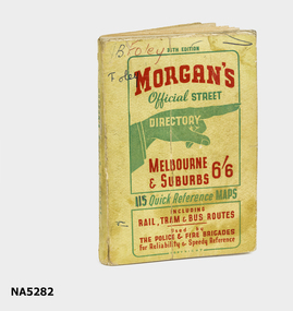
Map - Street directory, Morgans Official Street Directory
... Maps ...Morgan's street directories lack dates. Donor's parents, who lived in Blackburn, used this street directory .Small soft covered book of official street directory of Melbourne and suburbs.Morgans Official Street Directory Melbourne and Suburbs 6/6maps -
 Whitehorse Historical Society Inc.
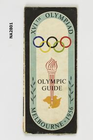
Memorabilia - Programme - Olympic, 1956
Program and guide map of city of Melbourne. Map of Melbourne and suburbs. Map of N.S.W. and Victoria.XVIth Olympiad Olympic Guide, Melbourne 1956.documents, programmes -
 Ringwood and District Historical Society
Map, Plan of Country Lands in the Parishes of Nunawading Ringwood and Scoresby - circa 1855
Blueprint copy of Survey Map detailing original Selectors' names and property locations. List of Parish map references including property bearings, distances in Links, and markings on trees. Descriptive remarks include areas marked "Farmer's Common", "Poor soil thickly/moderately timbered with stringy bark", and location of water and firewood reserves."Surveyed and plotted by N.M. Bickford, Superintendant of Mr. Hodgkinson's Field Party". "The land comprised in this survey is of inferior quality, moderately undulating, and thickly wooded. It is watered by Dandenong Creek and Deep Creek." Inset map showing location of (*proposed) cemetery on southern corner of Lillydale Road from Melbourne and Sawmill Road, later Mount Dandenong Road. (*Cemetery did not eventuate.) -
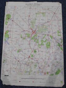 Bendigo Historical Society Inc.
Map - Bush Fire Control Map Bendigo District
A Bush Fire Control map is a valuable tool used by emergency services and communities to respond to respond to bushfires.Cream coloured parchment map showing roads, railway lines, telephone lines, rivers, creeks and water courses. Also marked are houses, Post Offices, Police stations, bush fire brigades, water channels, swamps, marshes, dense, medium and scattered timber, aqueducts and reservoirs. Villages, districts and Towns are clearly marked. Printed in red, green, black and blue. Very clear and easy to read. Undated.bush fires, bendigo area map -
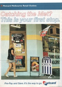 Melbourne Tram Museum
Pamphlet, VicTrip, "Catching the Met? - This is your first stop.", Apr. 1999
... Maps ...Pamphlet - four fold - special size - full colour titled "Catching the Met? - This is your first stop." giving the list of Metcard shops in central and suburban Melbourne, along with maps of the tram and train systems. The maps show both Yarra and Swanston trams with route numbers along with Bayside and Hillside trains and the various ticket zones at the time. The number of car parking spots at each station also shown. On the rear is general information about Metcard with ticket machines, and validators. List dated effective from April 1999.trams, tramways, maps, metcard, yarra trams, swanston trams, hillside trains, bayside trains, tickets -
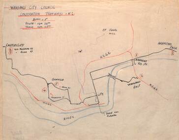 Ballarat Tramway Museum
Drawing - Wanganui NZ - Plan and Notes, Wal Jack, 12/1946
... maps ...Wal Jack had an extensive range of correspondents throughout Australia and the world who often provided him with detailed drawings and notes on various tramway systems. This set of notes on the Wanganui tram system and a list of the rolling stock dated Dec. 1946. The typed foolscap sheet listing the trams or rolling stock gives details on each tram. May have been used to prepare Wal's list. Map and the handwritten list of trams, based on the handwriting, prepared by Wal Jack himself. The typed list may have been prepared by others. Yields information about Wal Jack's extensive recording and research work.Drawing - black, red and blue ink or colour pencil, one hand written sheet and one double sided typed carbon copy foolscap sheet with ink notes over poor sections of type.tramways, wal jack, drawings, maps, tramcars, wanganui -
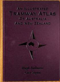 Ballarat Tramway Museum
Book, Hugh Ballment and Carl Segnit, "An Illustrated Tramway Atlas of Australia and New Zealand", 2018
... Maps ...Yields information about the extent and cities that had street tramway systems in Australia and New Zealand and in particular Ballarat.Book - hard cover, 9 sewn sections, full paper bound front covers, 120 pages, gloss paper printed in full colour titled "An Illustrated Tramway Atlas of Australia and New Zealand" with a table of contents by Hugh Ballment and Carl Segnit published by Transit Australia, 2018. Has a preface and acknowledgements, lists 23 Australian and 9 New Zealand cities that had public street tramway systems. Gives maps of the Tramway Museums at the time, trams on public displays and tramway museums that have closed. The Map for the Ballarat Tramway Museum line in Wendouree Parade is not correctly shown.trams, tramways, atlas, australian tramways, ballarat, maps, geelong, bendigo -
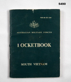 Bendigo Military Museum
Booklet - POCKET BOOK SOUTH VIETNAM, AUSTRALIAN ARMY, C 1962-1972
Aust soldiers going to South Vietnam were issued with this booklet Pocket size booklet. The cover is cardboards, jungle green colour. The printing is white. At the top of front cover is the Crest of Australia 72 pages- History of South Vietnam and culture. Enemy descriptions and drawings. Viet language. Ranks of US Army and SVN army. Maps Inside front cover.. Pte. P. J. PENNO 3790111 NUI DAT 67/68 Page 24 has a map of South Vietnam. A bird mark “x” has been placed on PHUOC TOY vietnam war, booklet -
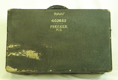 B-24 Liberator Memorial Restoration Australia Inc
Suitcase from Mason Day Frecker, 1930s
Suitcase issued to aircraft captains or crew by RAAF during World War II. The contents of M D Frecker's suitcase include World War II medals awarded to the owner, photographs, maps, pilots' handbooks, language dictionaries (Malay, Pidgin, Japanese), propaganda leaflets dropped by Japanese.Has historical and social significance, also research significance. Provenance known, owner piloted B-24 Liberator bombers and General Blamey's personal aircraft; item was donated by son. Great interpretive potential.Worn dark suitcase belonging to Mason Day Frekker, strong cardboard covered with 'leatherette', metal fasteners on front, with carry handle. Suitcase contains Flying Log Book RAAF, Wedding Photo, National Archives Record Search Mason Day Frecker, Distinguished Flying Medal Register WW2 x 3, Papers on Medals and Victorian Ground Crew Numbers, Files 1 - 2 - 3 - Photographs, Leaflets, Pilots' Notes, Maps - Germany (28 maps), Buttons and badges and other medals."RAAF/402653/Frecker/M.D." on top surface, "M.D.F." on front surface under handle.b24 liberator bomber, world war ii, raaf pilot, world war ii aerial photographs, a22.00 -
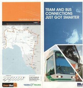 Melbourne Tram Museum
Pamphlet, Yarra Trams, "Tram and Bus connections just got smarter", 2008
... Maps ...Pamphlet - two fold DL full colour printed on semi gloss paper, titled ""Tram and Bus connections just got smarter", introducing Smart Bus route 903 from Mordialloc to Altona connecting with 9 different bus routes. Gives details of the smart bus system, its route, timetable information and has a map of the route on the rear. Dated 2008.trams, tramways, smart bus, buses, public transport, maps -
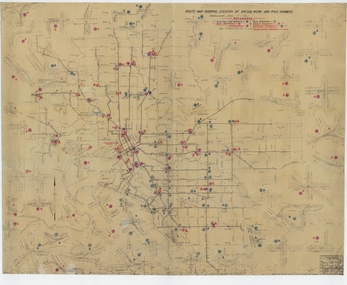 Melbourne Tram Museum
Drawing, Melbourne & Metropolitan Tramways Board (MMTB), "Route Map showing location of special work and pole numbers" "substations", late 1942
Map of the system shown at two inches = 1 mile. Drawing No. P5799. Shows crossovers, track layouts at junctions, signal cabins roads, railways, and stations. Originally signed by Perway Engineer - 20/12/1940, though originally drawn in 1922. The plan shows the lines to Maribyrnong Munitions works along Cordite Ave and Wests Road and the track from Moonee Ponds to Union Road, opened in July 1941, and the extension to Essendon Airport built in 1942, but not the Queen St North Essendon substation. Shows underground cables, tram and bus depot, workshop locations, and substation locations and their priority.Yields information about the MMTB substation locations in 1942.Drawing - dyeline cloth backed print - titled - "Route Map showing location of special work and pole numbers" and subtitled - "Substations". trams, tramways, mmtb, trackwork, tramways, junction, map, world war 2, substation -
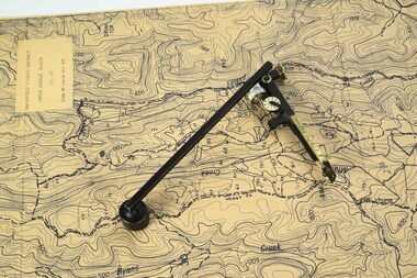 Department of Energy, Environment and Climate Action
Planimeter (fixed arm)
The heavy weight is pinned onto the map and the tracing arm is used to follow the boundary to be measured Reading the number of revolutions from the two the scale wheels the area in square inches could be measured. Knowing the scale of the mapsheet the figure was converted to areas or hectares Generally at least three measurements were taken to ensure accuracy and precisionPlanimeter used to measure areas from scale maps. Includes wooden box One revolution of the main wheel equaled 10 square inches. A smaller rotating scale on the side was used to subdivide the area.Benallaforests commission victoria (fcv), forest measurement, surveying -
Kew Historical Society Inc
Book, Geoffrey W Leeper, Introducing Victoria, 1955
Melbourne : Australian and New Zealand Association for the Advancement of Science ; Carlton, Vic. : Melbourne University Press, 1955 x, 306 p., 32 p. of plates (some col.) : ill., col. maps ; 22 cm. non-fictionvictoria -- history, victoria -- description and travel, victoria -- natural resources -
 City of Kingston
Map - Parish of Moorabbin
Warning: This object includes historical language referring to First Nations Peoples which is no longer appropriate but has been recorded for historical purposes. Produced in 1853, this map shows the land holdings of European families. While the majority of holdings are small there are also large land holdings as can be seen with Henry Dendy's Special Survey. Of particular note is the "Reserve for Aborigines" which was established in approximately 1841 and consisted of over 830 acres. This area is the current location of Mordialloc township and Attenborough Park, in Mordialloc, is the last remnant of the reserve. An Alfred Sikes, possibly the surveyor/cartographer who drew this parish plan, purchased land in Berwick in 1854.A handrawn map on fabric, with blue markings representing the coastline to Port Phillip Bay, red markings representing a proposed train line to Mordialloc, major roads and street, as well as a "Reserve for Aborigines", which constituted approximately 830 acres. In the bottom right hand corner, the map has been signed and dated.Handwritten in ink: Alfred Sikes / 38 Collins St East / June. 1853moorabbin, mordialloc, dendy, port phillip bay, aboriginal reserve, attenborough park -
Bendigo Historical Society Inc.
Map - HUNTLY ? (NO NAME ON PLAN), Circa 1876
Map: Huntly?. Hand Draughted parish plan. Originally in Map Cupboard. Relocated to Map Drawer 5 on 22.9.22. Too long for the map cupboard.map, bendigo, parish plan, huntly -
Whitehorse Historical Society Inc.
Map, Nunawading Planning Scheme, 7/06/1994 12:00:00 AM
... maps ...Local Section maps 1 - 4 with index. Geographical information system land Information Branch. Scale 1:10,000 Shows zoning under planning scheme.Local Section maps 1 - 4 with index. Geographical information system land Information Branch. Scale 1:10,000 Shows zoning under planning scheme.Local Section maps 1 - 4 with index. Geographical information system land Information Branch. Scale 1:10,000 Shows zoning under planning scheme.blackburn, blackburn north, blackburn south, forest hill, heatherdale, maps, nunawading, vermont, vermont south, town planning, burwood east, laburnum -
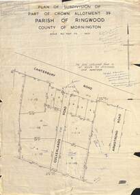 Ringwood and District Historical Society
Map - Plan of Subdivision, Part of Crown Allotment 39, Parish of Ringwood, County of Mornington - (Undated - circa 1930s)
Copy of land title map on light cardboard backing showing layout and size of 11 allotments in Canterbury Road and Culverlands Road, Heathmont, Victoria. Hand-written sales notations on map and backing include names and telephone numbers - Mr Robinson MJ2411, Mr Smith MX5425, Abicare WY1848. Later notation 12/12/67 - A. Robertson. Rubber stamp imprint in top left corner - D.H. Oliver, Civil Engineer & Licensed Surveyor, Bellevue Street Lilydale, Phone Lilydale 91. -
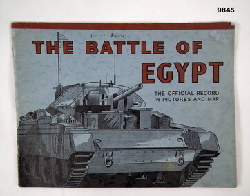 Bendigo Military Museum
Book - PICTORIAL, WW2, WAR OFFICE, "THE BATTLE OF EGYPT", 1942
Information from the front cover; "THE BATTLE OF/ EGYPT/ THE OFFICIAL RECORD/ IN PICTURES AND MAP" Part of the William (Bill) THOMASON Collection. Refer Cat. No. 4136P for more items.Soft cover book. Cover - blue colour cardboard, red and black colour print on front and back. Front illustration - black ink sketch of a tank. 35 pages - cut, plain, off white colour paper. Pictorial book with black and white photographs and map. Fastened with metal staples. Front cover - handwritten owner's information.Handwritten owner's information - black ink pen, "Norma Davis".publications, books, egypt, ww2, william (bill) thomason collection -
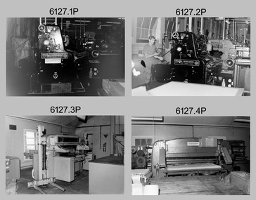 Bendigo Military Museum
Photograph - Print Troop – Lithographic Squadron – Army Survey Regiment, Fortuna, Bendigo, 1986
This collection of twenty photos was most likely taken in Lithographic Squadron, Army Survey Regiment, Fortuna, Bendigo in 1986. Print Troop’s technicians were most likely operating the Komoni, Planeta or Ultra-MAN-III offset printing presses and working in the map despatch dock. Although these photos are not annotated most personnel are positively identified.This is a set of twenty photographs of Print Troop personnel and equipment from Lithographic Squadron at the Army Survey Regiment, Fortuna, Bendigo, 1986. The photographs were on 35mm negative film and were scanned at 96 dpi. They are part of the Army Survey Regiment’s Collection. .1) - Photo, black & white, 1986, Original Heidelberg Printing Press. .2) - Photo, black & white, 1986, Original Heidelberg Printing Press, unidentified technician. .3) - Photo, black & white, 1986, Heavy-duty paper guillotine. .4) - Photo, black & white, 1986, Polygraph Heavy-duty paper guillotine. .5) - Photo, black & white, 1986, Newkoni Komori Printing Press .6) - Photo, black & white, 1986, Ultra-MAN-III Printing Press, Russ Mollenhauer. .7) - Photo, black & white, 1986, Print roller cleaning tank .8) - Photo, black & white, 1986, Planeta Polygraph Printing Press .9) - Photo, black & white, 1986, Planeta Polygraph Printing Press .10) - Photo, black & white, 1986, Roy Hicks, unidentified technician, Steve Egan, Dale Hudson. .11) and .12) - Photo, black & white, 1986, L to R: Paper drilling machine, wire stitcher. .13) - Photo, black & white, 1986, Map Despatch dock, Greg Rowe. .14) - Photo, black & white, 1986, Print area, Pear Andersen. .15) - Photo, black & white, 1986, Map Despatch dock, Pear Andersen. .16) - Photo, black & white, 1986, Map Despatch dock, .17) - Photo, black & white, 1986, Map Despatch dock, Russ Mollenhauer. .18) - Photo, black & white, 1986, Map Despatch dock, unidentified technician. .19) - Photo, black & white, 1986, Map Despatch dock. Peter Dillon, Mick Minchin. .20) - Photo, black & white, 1986, Map Despatch dock.No personnel are identifiedroyal australian survey corps, rasvy, army survey regiment, army svy regt, fortuna, asr, litho, printing -
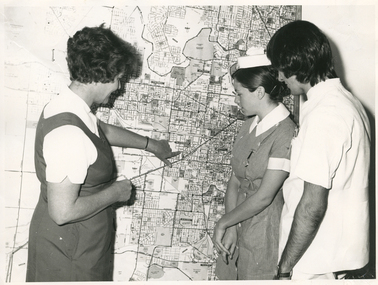 Royal District Nursing Service (now known as Bolton Clarke)
Photograph - Photograph, black and white, Barry Sutton, 01.05.1974
Sister Ellen Anderson is the Supervisor of the Royal District Nursing Service, (RDNS) Footscray Centre. She is wearing her RDNS uniform of a short sleeve white blouse under a royal blue V neck tunic style dress. Sr. Anderson is showing two Student nurses from Western General Hospital the map with the areas covered by Footscray Centre. The map had different colour pins to identify streets where patients lived who were currently receiving nursing care from RDNS Sisters working in these areas (districts).During their training, Student nurses from several hospitals either attended the Royal District Nursing Service (RDNS), Education Department, or, a RDNS Nurse Educator travelled to the appropriate hospital’s Education Department to educate the Trainees on District nursing through the RDNS Community Nursing Program. Following the lectures Students went to a RDNS Centre and each Student accompanied a Trained nurse (Sister) for a week observing and gaining knowledge of all facets of nursing care in the home. This gave them an insight into the home conditions and situations patients faced after discharge from hospital. During 1971 there were 584 Student nurses who received field experience with RDNS. From its inception as Melbourne District Nursing Society (MDNS), in 1885, their Trained nurses (Nurses) worked in specific areas, 'districts'. The first Nurse worked east and west, between Victoria Parade and Flinders Street and, north and south, between Spencer Street and Spring Street. When a second Nurse was employed they divided this area at Elizabeth Street so each Nurse could attend to patients in the same area giving continuity of care. As the Society expanded, becoming Melbourne District Nursing Service, then, with Royal patronage, Royal District Nursing Service (RDNS) many Centres were opened throughout the Melbourne Metropolitan area and outer suburbs. The District nurse's areas (districts) grew and were divided within Shire boundaries for e.g. Knox 1, Knox 2, Knox 3, Knox 4, within the area of the Shire of Knox. A map covering the Centre’s Districts was attached to a wall, and its different colour pins identified streets where patients lived who were currently receiving nursing care from the RDNS Trained nurses (Sisters) working in these areas (districts).On the left of this black and white photograph is Royal District Nursing Service (RDNS), Sister Ellen Anderson, who has short dark curly hair and is wearing her RDNS uniform of a short sleeve white blouse under a dark V neck tunic style frock. She is standing side-on, towards the right of the photograph, and with her left hand is pointing to an area on a large map attached to the wall in the background. To her right, is a Student nurse who is facing Sr. Anderson, and looking at the area on the map. Under her white nurses cap, she has her long dark hair drawn back, and is wearing her hospital uniform of a short sleeve checked dress with white collar and cuffs; a nursing watch is attached to its upper left; her hands are clasped in front of her. To her right, is a male Student nurse who has collar length straight dark hair, and is wearing white trousers and a short sleeve white top with pens in the left upper pocket. He is looking at the areas on the map.. Barry Sutton MA 77 informationroyal district nursing service, rdns, rdns education, rdns centre, rdns district map, sister ellen anderson -
 Woodend RSL
Map, Afghanistan South Western Oruzgan Helmad and Kandahar Province’s July 2009, September 2009
Map was used by Alan Mitchell-Lapin during patrols with Commando Regiment. Alan Mitchell-Lapin is a resident of Woodend.Alan Mitchell-Lappin is a member of the Woodend RSL who served with the Commandos in Afghanistan. Alan was awarded a Commendation for Gallantry for his service in Afghanistan. The map was utilised by Alan during his patrols.Patrol map for South Western Orguzgan Helmand and Kandahar Province’s. Scale 1:200,000. Produced by Australian Government Department of Defence Intelligence and Security. Table top right -Military Legend. Tables middle right - Language distribution, and translation glossary. Table bottom right hand corner - Topograhic Legend. Table centre bottom - Grid magnetic Diagrams. Table top left corner - Tarwin Kowt weather infromation.Produced by the Defence Imagery and Geospatial Organisation, Geospatial Analysis Centre, September 2009. Restricted at time of issue.afghanistan, map, orguzgan, helmand, kandahar, operation slipper, mitchell-lapin, 2009, digo 0098-0910, commando, special forces -
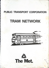 Melbourne Tram Museum
Book, Public Transport Corporation (PTC), "Tram Network", late 1980s
... Maps ...Titled "Metropolitan Tram Network" published by Public Transport Corporation with a drawing of an A class tram on the cover along with a The Met logo. Provides information in map form on each tram route in a large print format, contact numbers and some general information as a disability service. Gives details of Met customers services, office hours and Legend. See also item 1181 and 6000 for other examples. Possibly late 1980s as the Port Melbourne and St Kilda Light rail lines are detailed.Demonstrates the provision of information about Melbourne's tram routes at the time.Book - wire bound, 34 pages + card covers.tramways, ptc, the met, maps, disability services, tram routes, routes -
 Ringwood and District Historical Society
Document - Subdivision Map, Part of Crown Sections 18, 19, 24 & 25, Parish of Warrandyte, County of Evelyn, Vol 5228 Fol 472 - 1926. (Park Orchards, Victoria)
A3 and A4 sized photocopies showing map section of land title showing streets, easements and allotment numbers, some with handwritten names and pricing notations circa mid 1950s.Map includes Valley Road, Granard Avenue, Park Road, Arundel Avenue, Hylton Avenue, Aviemore Avenue, Bowmore Avenue, Hopetoun Road, Colin Avenue, Daintree Avenue, Brucedale Crescent, Feversham Avenue, Ennismore Crescent, Iona Grove, Elgin Crescent and Gosford Crescent, Park Orchards, Victoria. -
 Port Melbourne Historical & Preservation Society
Document, Hotels in Port Melbourne
The letter on the outside of the sheet is from Jim (?) to Les (Turner). It gives some of his childhood recollections of Port Melbourne Hotels These include the Shamrock which he understood that it was "... a weatherboard Building - very Badly Conducted and when it was burned down it was not rebuilt... I did know that there was a murder there."Inside is hand drawn map of Port Melbourne with the hotels marked in position as well as a Key down the left hand side. The accompanying typed sheet lists the 50 original hotels on the left hand side and the 20 remaining on the right.A large ruled sheet of paper with a letter on the outside & inside a hand drawn map of Port Melbourne with the location of hotels marked. A typed sheet lists the hotels.Hotels of Port Melbourne. Originally there were 50. today there are 20.business and traders - hotels, shamrock hotel, leslie stanley turner -
Bendigo Historical Society Inc.
Map - TARNAGULLA SHEET 3, No date Visible
Map: Tarnagulla Sheet 3, hand written on the side of the map. ( number 152 in Map Cupboard 1)map, parish plan, tarnagulla -
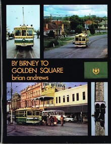 Melbourne Tram Museum
Book, Brian Andrews, "By Birney to Golden Square", 1973
... Maps ...Book, 78 pages including card cover, printed on gloss paper, titled "By Birney to Golden Square", written by Brian Andrews, published by Southern Cross Traction, Kensington Park SA. Sub-titled "The last years of Bendigo's tramways", 1973. Features both black and white and colour photographs, including tickets, photos along each route, Charing Cross, depot, notes on the rolling stock with an aerial photograph of Bendigo with the tram routes marked in and a fold out detailed map of Bendigo and its track layout.trams, tramways, secv tramways, bendigo, maps