Showing 173806 items
matching pitt-street
-
 Eltham District Historical Society Inc
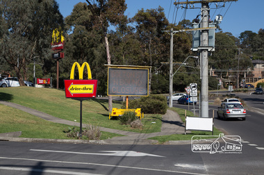
Photograph, Peter Pidgeon, McDonalds Restaurant, cnr Bridge Street and Bolton Street, Eltham, during Bolton Street upgrade, 13 November, 2017, 13/11/2017
North bound lane closureBorn Digitalbolton street, bolton street upgrade, eltham, streets, bridge street, mcdonalds restaurant -
 Eltham District Historical Society Inc
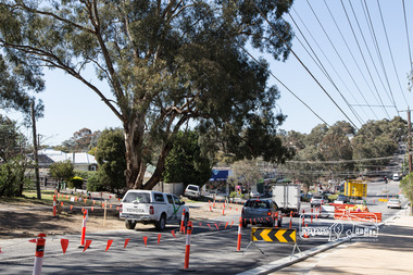
Photograph, Peter Pidgeon, Looking south towards Walsh Street and Bolton Street shops, Bolton Street upgrade, Eltham, 13 November, 2017, 13/11/2017
North bound lane closure. Born Digitalbolton street, bolton street upgrade, eltham, streets, walsh street, bolton street shops -
 Greensborough Historical Society
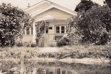
Photograph - Digital Image, Cherel Sartori, Electricity connected in Henry Street, 1950s, 1956c
Kell's Cottage with electricity connected 1950s. The house was built 1917, at 112 Henry Street Greensborough by William Mitchell on the 60 acre dairy farm owned by Ethel and Walter Kell. This collection of photographs was copied by Cherel Sartori (who owned the house from 1990-2000), following a visit by Claude Amiet who lived in the house as a child in the early 20th century.An indication of the rural aspect of this area in the mid-20th century.Digital copy of black and white photographkell's cottage, claude amiet, cherel sartori -
 Greensborough Historical Society
Photograph - Digital Image, Cherel Sartori, Paddock and gates in Henry Street, 1950s, 1956c
Paddock and driveway at Kell's Cottage 1950s. The house was built 1917, at 112 Henry Street Greensborough by William Mitchell on the 60 acre dairy farm owned by Ethel and Walter Kell. This collection of photographs was copied by Cherel Sartori (who owned the house from 1990-2000), following a visit by Claude Amiet who lived in the house as a child in the early 20th century.An indication of the rural aspect of this area in the mid-20th century.Digital copy of black and white photographkell's cottage, claude amiet, cherel sartori -
 Wangaratta RSL Sub Branch
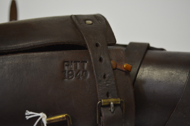
Uniform - Leather Leggings
Leggings were known to be worn by the Australian Light Horse and other units such as ArtilleryDark brown leather curved to leg shape, with leather straps and buckles.Pitt 1940light horse, leggings, uniform, wwii, world war 2 -
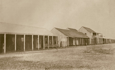
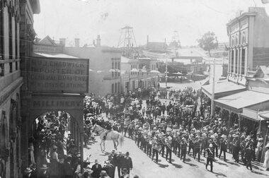 Stawell Historical Society Inc
Photograph, Upper Main Street Stawell procession with the band & a police constable on Horseback visible c1901
Main Street Procession East End Circa 1901. Stawell Brass Band plus Constable on Horseback visible. J Chadwick Importer of General Drapery with Boys Clothing on sign on left. Millinery on side of verandah. Commercial Hotel just visible on left. Sloane's & Scotchmans Poppet head Visible in background on right. Poppet Head in background on Big Hill on left is Crown Cross shaft.Croud of people lead by band in upper main street. Chadwick drapers on left. Mounted policeman on horseback in front of Commercial Hotel.stawell businesses streetscape -
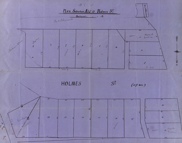 Federation University Historical Collection
Map, Plan subdivision: Allotment 12 Holmes Street, Ballarat
The Allotments drawn in Holmes Street appear to be hand drawn and showing one of the first subdivisions in Ballarat. This was begun in the 1860s. Some names are marked on the blocks - Taylor (9), Holmes (6), Robert Watson (3), Watson (16), Walter (18),Wetherly (11), Vacant (7)Blue paper with black ink showing the land blocks either side of Holmes Street Each block is numbered - 20 in all Names on some blocksNorth indicated with arrow Sizes of blocks - depth and width holmes street, subdivision, allotment 12, holmes, taylor, robert watson, watson, wetherly, vacant -
 Ringwood and District Historical Society
Envelope, Packet: Ringwood Council and Ron Pullin list of Street Names. 1971 and 1972
Street Names - List of names for consideration for streets in Ringwood +Additional Keywords: Pullin, E.V. -
 Ballarat Heritage Services
Photograph, Clare Gervasoni, House in South Street, Ballarat, 2020, 13/04/2020
Colour photograph of houses in Lyons Street South, Ballarat, near the intersection of South Street.ballarat, cast iron, lyons st, lyons street south -
 Ballarat Heritage Services
Photograph, Clare Gervasoni, House in Lyons Street South, Ballarat, 2020, 13/04/2020
Colour photograph of houses in Lyons Street South, Ballarat, near the intersection of South Street.ballarat, cast iron, lyons st, lyons street south, architecture -
 Ballarat Heritage Services
Photograph, Clare Gervasoni, House in Lyons Street South, Ballarat, 2020, 13/04/2020
Colour photograph of houses in Lyons Street South, Ballarat, near the intersection of South Street.ballarat, cast iron, lyons st, lyons street south, architecture -
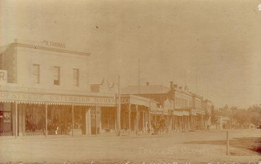 Clunes Museum
Photograph, C 1905
EARLY PHOTOGRAPH OF FRASER STREET, CLUNESORIGINAL SEPIA POSTCARD PHOTOGRAPH OF CLUNES MAIN STREET, FEATURING HORSE AND CART AND R. THOMAS CRITERION HOUSE DRAPER SHOP.FRASER STREET CLUNESlocal history, photography, photographs, shops, r. thomas criterion house draper shop., clunes township -
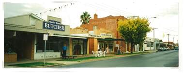 Tatura Irrigation & Wartime Camps Museum
Photograph, Douglas Quality Butchers Hogan Street Tatura
Shows picture of Douglas Quality Butcher, Hogan Street, Tatura. Also Bank of New South Wales and National Bank.Colour photograph showing Douglas Quality Butcher in Hogan Street, Tatura and other businesses to the right of the butchers including the Bank of New South Wales and National Bank. Photograph stuck onto piece of white cardboard. hogan street tatura, douglas butchers tatura, bank of new south wales tatura, national bank tatura -
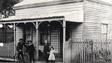 Linton and District Historical Society Inc
Photograph, The Todd House in Sussex Street, Linton, early 1900s
The Todd family lived in this house in the early 1900s. The house was next door to the butcher's shop which was run by members of the Todd family at the time. Stella Todd is the small child on the right of the photograph, whose hand is being held by her older sister (who is possibly Millie Todd). It is believed this house later burned down and was replaced by the house which currently occupies the site (65 Sussex Street).Black and white copy of original photograph which shows a weatherboard house with a front verandah and a picket fence. Two boys, one on a bicycle, and two girls, the older holding the younger's hand, are posing for the photograph in front of the fence.houses, todd family, stella todd -
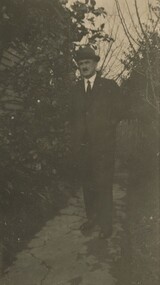 Surrey Hills Historical Society Collection
Photograph, David Miller Mair, 20 Barton Street
David Miller (Dave) Mair (1879-1938) married Lily Vipond Deakin (1890-1945) in 1910. They had 5 children: Geoffrey David (1913-1970), Beryl (1916-1976), Gwynneth (1917-1997), Isabel Lillian (1921-1997) and Shirley Inez (1928-1968). His parents were Isabella Brown (1856-1944) and William Mair (1850-1924). Personal communication from Laurie Newton, Beryl's daughter: Dave and Beryl initially lived in East Melbourne after they married. Geoffrey, Beryl and Gwynneth were born in East Melbourne. They subsequently moved to Louise Avenue, Mont Albert and Isabel may have been born while they were there. Later they purchased 20 Barton Street, Mont Albert. Shirley was born after they moved to Barton Street. The children attended Mont Albert Central School. Dave was an extremely keen sportsman (particularly bowls and cricket). He started the Kangaroo Cricket Club and worked for the Melbourne Cricket Club.This is part of a large donation related to the Deakin, Mair and Young families with connections to the Surrey Hills / Mont Albert area.A sepia copy photo with a cream border of a man in suit and tie, wearing a bowler hat and standing on a concreted area with bushes with either side of him.REAR: In blue biro - "Dad / David Millar Mair / South sideway of / Barton St" Handwriting is thought to that of Beryl Young (nee Mair). "indeciperable number" in lead pencil. -
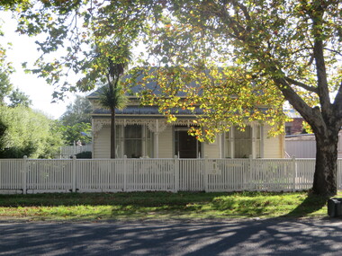
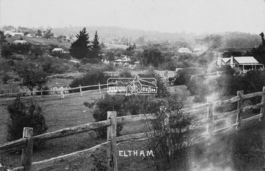 Eltham District Historical Society Inc
Photograph (item), J.H. Clark (poss), View of Eltham across Bridge Street, c.1907
The view is looking southeast from near Eltham Road (present-day Sherbourne Road) across Bolton and Bridge streets towards the village of Little Eltham running down the main road (Maria Street) . On the immediate right is Mrs Mary Jane Smart's family home located on the north side of Bridge Street at the intersection with Bolton Street, facing Bolton Street (now part of present day Brisbane Street and occupied by the Kitchen Design Centre). An original early settler's cottage, it was built by Mary Jane Smart's parents, Edwin Bailey and Jane (nee Matthews). Mary Jane Smart was born in the cottage. She married an Englishman, Alexander Wilson Smart who disappeared to Western Australia in the early 1900s in search of gold. He ultimately married again in W.A., committing bigamy and then committed murder and was hung in 1911. Visible att the top left are Watson's (two-storey) Eltham Hotel at the corner of Pitt Street and Maria Street and the Evelyn Hotel directly opposite. The photo was possibly taken by John Henry Clark of Clark Bros Photographers who operated from 25 Thompson Street, Windsor near Prahan 1894-1914.bridge street, clark bros. photo, early settlers, eltham, evelyn hotel, fountain of friendship hotel, j.h. clark photo, mary jane smart (nee bailey), smart family home, smart home, watsons hotel -
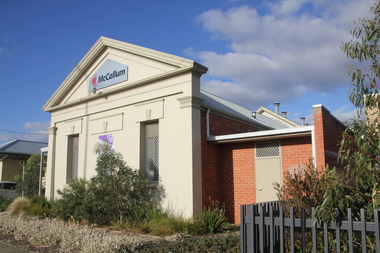 Ballarat Heritage Services
Photograph - Photograph - Colour, Former Masonic Lodge, Albert Street, Sebastopol, 2018, 12/03/2018
The Sebastopol, or Guiding Star Lodge was consecrated on 22 May 1999 following the amalgamation of ‘Hope No. 274’, ‘Orion No. 53’ and ‘Sebastopol No. 63’, three of Ballarat’s oldest Freemasons Lodges with a combined total of over 345 years of masonic history, and is chartered under the United Grand Lodge of Victoria. In 2011 the Sebastopol and other Central Ballarat Lodges were sold, with the lodges now meeting at 616 Barkly Street, Golden Point. Colour photograph of the former Sebastopol Masonic Lodge.sebastopol, sebastopol masonic lodge, guiding star lodge no 222 -
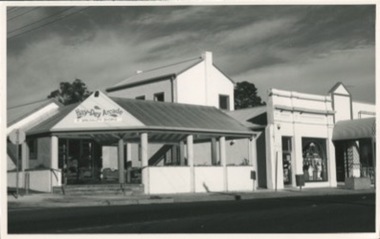 Kilmore Historical Society
Photograph, 11 and 13 Sydney Street
13 Sydney street was the site of J. Quinn bakery and the site of Breakells Bakery.20.5cm x 13cm black and white photograph of the Hey Dey Arcade which the main awning/gazebo of the complex is on the corner at 11 Sydney Street. Also to the right of the awning is the building which was Breakells Bakery. The shop at that premises in the photo is J.R. Menswear.Written on the back: 12/13 KOSR-245 560 63%bakers, bakery, bakers and bakeries -
 Stawell Historical Society Inc
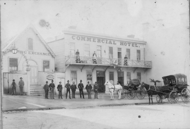
Photograph, Mining Exchange and Commercial Hotel built 1861 in Upper Main Street Stawell c1880
Upper Main Street Stawell. Mining Exchange and Commercial Hotel built 1861. Photo c1880. Hotel housed the Victoria Theatre. Commercial Hotel built and licensed in 1861 and added to over the years. About 1865 an assembly room/theatre was erected at the hotel, part of this was the assembly room of the Quartz Miners Hotel in Upper Main Street which had been demolished on account of the increased mining in the area. The assembly room was the only theatre at the Reefs until the Town Hall was erected. It was called the Victoria Theatre. In 1878 the Stawell paper reports that the Court of Petty Sessions had been held in the Victoria Theatre at the Commercial Hotel. Mr Sauerbrey was the owner of the Hotel in 1869 and he advertised extensive additions of sitting-rooms, bedrooms & bathrooms. First class stabling and carriage house. Rooms for Mining Meetings and bookings for Cobb & Co.Commercial Hotel with first floor balcony. Eight men lined up in street and three women on balcony. Two horse drawn buggies on right.stawell streetscape, hotel -
 Stawell Historical Society Inc
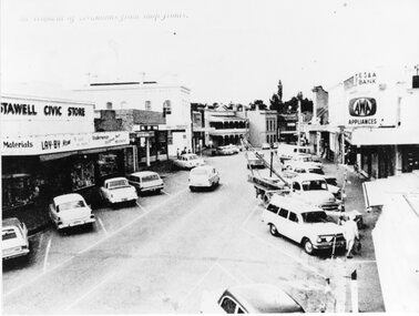
Photograph, Upper Main Street Removal of Verandahs, 1960's
Stawell Civic Store, Senghpa's, Commercial Hotel, Oriental Bank/Bank of Australasia, ES & A Bank Upper Main Street Taken from higher up with cars in Main Street looking eastThe removal of verandahs from shop frontsstreetscape -
 Whitehorse Historical Society Inc.
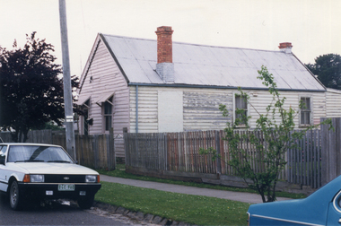
Photograph, House - Edward Street Mitcham
Coloured photograph of house in Edward Street Mitcham, since demolished for the Britannia Street Car Park.edward street, mitcham -
 Ballarat Heritage Services
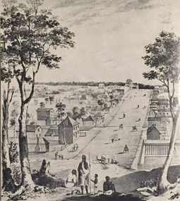
Image, Collins Street, Melbourne in 1840, 1934
A drawing of Collins Street, a main street in Melbourne Victoria. Aborigines stand in the foreground overlooking the scene. collins street melbourne, melbourne, aborigines -
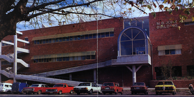 Federation University Historical Collection
Image - Colour, Ballarat School of Mines M.B. John Building, Albert Street, Ballarat, 1987, 1987
The M.B. John Trade–Art building (Albert Street front) of SMB was officially opened by the Hon. John Cain, Premier of Victoria, in the presence of Morgan B. John. Programs include 3 Dimensional Art, Painting & Decorating, and Engineering Trades. (SMB Institutional Plan 1989) The M.B. John Building (Building K), a three storey, face red brick, restrained Late Twentieth Century International styled building with an elongated, cuboid form (defined by the parapeted facades) that is offset by projecting exposed concrete framed, round‐arched entrance and stair wells on the east (Albert Street) elevation (the centrally located entrance breaking the brick façade with glazing). The facades are also characterised by banks of aluminium framed, horizontal ribbon windows, which wrap around the building corners. Metal shades project beyond the windows, while post‐supported bullnosed verandahs and hoods and projecting concrete stairs are other features. On the west elevation, the cuboid façade is punctuated by projecting curved concrete and glazed, elongated bays at first floor level. (David Rowe/Wendy Jacobs)Image of a multi-storey brick building on the Ballarat School of Mines campus. The building is known as the M.B. John Building.ballarat school of mines, m.b. john building, morgan b. john, albert street, m.b. john -
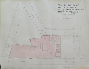 Federation University Historical Collection
Plan, Plan of Survey of Part of Section 9A City & Parish of Ballarat County of Grenville (Albert Street frontage), 1932
The M.B. John Trade Building was built on the Albert Street Frontage..1) Plan of SMB showing Albert, Grant, Lydiard and Dana streets, on paper with colored highlights undertaken by Ballarat School of Mines student George Murrowood in 1932 .2) Hand written page by George Murrowood, of technical description of land surveying Grade II 1932ballarat school of mines, surveying, george murrowood, albert street, alumni, m.b. john building, architectural plan -
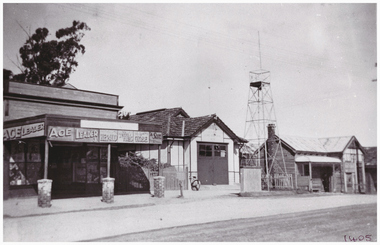
 Stawell Historical Society Inc
Photograph, Pleasant Creek Special School, Stawell Technical School Patrick Street Nov 1975, Nov 1975
Photographs taken by teacher at Pleasant Creek Training Centre to help train students in living skills and becoming familiar with what shops sold. Part of socializing students for leaving the training centre.Patrick Street Building education, streetscape -
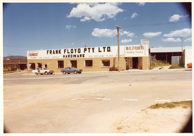 Stawell Historical Society Inc
Photograph, Pleasant Creek Special School, Frank Floyd Pty Ltd. Hardware Store, Wimmera Street Stawell Nov 1975, Nov 1975
Photographs taken by teacher at Pleasant Creek Training Centre to help train students in living skills and becoming familiar with what shops sold. Part of socializing students for leaving the training centre.Wimmera Street Stawell education, streetscape -
 Ballarat Heritage Services
Photograph - Photograph - Colour, Darwin Main Street, China Town, c1912, 1912
The main street of Darwindarwin, china town -
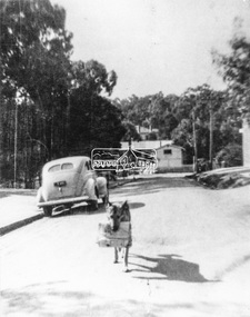 Eltham District Historical Society Inc
Negative - Photograph, Were Street, Montmorency, c.1948
Black and white photograph depicting a dog (named Jack) carrying newspaper delivery from the railway station up Were Street (to the Post Office). Mr. and Mrs Musselwhite ran the post office and owned Jack (the Alsatian dog) which was trained to go down to the railway station each day about 3pm and collect the daily parcel of evening newspapers, delivered by train, and take the bundle up to the newsagency. It is believed the Musselwhite's ran the Post Office from the mid 1930s to circa 1950.This photo forms part of a collection of photographs gathered by the Shire of Eltham for their centenary project book," Pioneers and Painters: 100 years of the Shire of Eltham" by Alan Marshall (1971). The collection of over 500 images is held in partnership between Eltham District Historical Society and Yarra Plenty Regional Library (Eltham Library) and is now formally known as 'The Shire of Eltham Pioneers Photograph Collection.' It is significant in being the first community sourced collection representing the places and people of the Shire's first one hundred years.Digital image 4 x 5 inch B&W Negsepp, shire of eltham pioneers photograph collection, montmorency, were street, musselwhite, newsagent, alsatian (dog), jack (dog), montmorency railway station, shopping centre, were street shops -
 Linton and District Historical Society Inc
Photograph, Murrell's Newsagency, Sussex Street, Linton, circa 1940
William Murrell ran a newspaper shop on the west side of Sussex Street until 1932, when he moved his business to a site formerly occupied by Dan Cornish (who ran it as a shoe shop). After William Murrell died the newsagency was run for many years by his daughter Carrie Murrell.Black and white photograph which shows buildings along the east side of Sussex Street, including Murrell's newsagency, the fire brigade building, and another shop or dwelling.murrell's newsagency, linton fire brigade building, buildings, shops, sussex street linton -
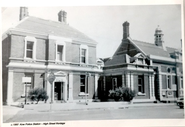 Kew Historical Society Inc
Postcard, Kew Police Station, c.1960
In c.1960, when the photograph was taken on which the postcard is based, both buildings were still owned by the Victorian Government and were a functioning police station and court house. In 1900, ownership of the post office had been transferred to the new Commonwealth Government. In the first decade of the twenty-first century, the police station and court house were offered for sale. They were subsequently purchased and renovated by the City of Boroondara. The Kew Historical Society raised over $5000,000 as a contribution to the restoration.Kew Police Station at left and Kew Court House at right. Monochrome (copied) postcard showing two buildings which are part of a larger complex (once including a post office) built by the Government of Victoria in 1888. The buildings are located at the junction of High Street and Cotham Roads in Kew. The frontages shown face High Street. "c.1960. Kew Police Station. High Street Frontage"kew court house -- high street -- kew (vic.), kew police station -- high street -- kew (vic.), public offices -- kew (vic), queen ann revival -- architectural style