Showing 28530 items
matching street street
-
 City of Kingston
Photograph - Black and white, 20 December 1945
... , (top left), Jellicoe Street, Argus Street, Bernard Street... on Chesterville Road near Bernard Street to establish a market garden ...Cheltenham is a suburb in the City of Kingston that was originally established as a rural market gardening community. The area is bordered by Highett, Mentone and Heatherton. The market gardens, farms and paddocks have gradually been sub-divided into housing and industrial estates. The Southland shopping centre is a major feature of the area.Cheltenham was established as a rural market gardening community. The Le Page family lived in Cheltenham since 1854 when Nicholas Le Page, a tailor from the Channel Island of Guernsey, bought two acres of land on Chesterville Road near Bernard Street to establish a market garden. Over the years the Le Pages purchased more land in the area. In 1875-76 Nicholas' son Frank and his wife Mary built 'Daphne Cottage' near the corner of Bernard and Wilson Streets. n the 1940s Frank's son, Everest Le Page, bought five more lots of land in Chesterville Road from the Tuck family. The Le Pages grazed horses, ponies and cows on this land, and grew pumpkins, carrots, parsnips, onions, potatoes and cabbages. Many buildings and locations within in Cheltenham commemorate the Le Page family's contribution to the Cheltenham community.Aerial photograph taken in 1945 of the Cheltenham district within the City of Kingston. The image includes Chesterville Road, the future site of Turner Road pool (now Waves) and Highett Reserve, (top left), Jellicoe Street, Argus Street, Bernard Street, Wilson Street, the Methodist Children Homes (now Southland), McIvor Street, Goulburn Street, Nepean Highway, Jamieson Street and Barker Street (bottom left), market gardens and paddocks. In the top centre of the image, "Daphne Cottage", the home of Frank T. Le Page is visible on the corner of Bernard and Wilson Streets. Much of the land depicted in this image was owned by the Le Page family. This image is possibly from the collection of aerial photographs commissioned by the Department of Crown Lands and Survey and taken by Adastra Airways.Black and white ink: 57250 White print: VIC-170 57250 20.12.45 Run 6 PROJ. No. 5 MELB. METROP AREA Black type 10200 FTS 30' LENS 20.12.45cheltenham, market gardens, industry, le page family -
 Bendigo Historical Society Inc.
Photograph - ESTELLAE HEWSTON COLLECTION: PHOTOGRAPH SANDHURST GRAMMAR SCHOOL CNR BARNARD & BANCROFT STREETS
... & Bancroft Streets Bancroft Street frontage... Inc. History House 11 Mackenzie Street Bendigo goldfields ...Colour photograph: Sandhurst Grammar School, cnr Barnard & Bancroft Streets Bancroft Street frontageEstelle Hewston -
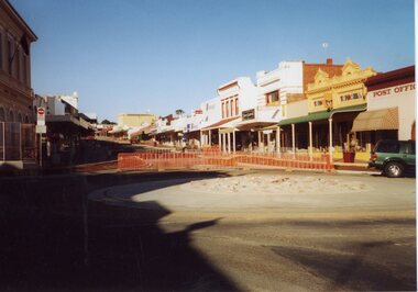 Stawell Historical Society Inc
Photograph, Gold Reef Mall -- Main Street Stawell 2003
... Gold Reef Mall -- Main Street Stawell 2003...Gold Reef Mall Main Street 2003...Colour Photograph: Looking Eastfrom the Main Street... grampians Gold Reef Mall Main Street 2003 stawell business Colour ...Gold Reef Mall Main Street 2003Colour Photograph: Looking Eastfrom the Main Street / Wimmera Street intersection, with roundabout partialy installedstawell business -
 Whitehorse Historical Society Inc.
Photograph, Home of Edgar Fredrick Walker, 1/09/1976 12:00:00 AM
... benares street... on the corner of Benares Street & Meerut Street... Mitcham melbourne benares street mitcham australian tesselated ...Black and white photo of Edgar Fredrick Walker's home on the corner of Benares Street & Meerut Streetbenares street, mitcham, australian tesselated tile co. pty. ltd. -
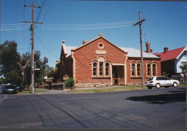
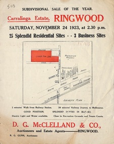 Ringwood and District Historical Society
Flyer, Subdivisional Auction Sale Brochure, Carralinga Estate, Ringwood, Vic. - 1923
... Subdivision includes Ringwood Street, Bourke Street... Street, Bourke Street and Bond Street. (Agent) D.G. McClelland ...Double sided folded page with black and red print on both sides advertising auction sale of residential and business sites and highlighting local facilities, services and layout of the estateSubdivision includes Ringwood Street, Bourke Street and Bond Street. (Agent) D.G. McClelland & Co., Auctioneers and Estate Agents. Phone 37. R.G. Gunn, Auctioneer. -
 Stawell Historical Society Inc
Photograph, Stawell Aerial View Centred on Town Hall in Main Street 1998 -- Coloured
... Stawell Aerial View Centred on Town Hall in Main Street.... Main Street. Scallan Street Childe Street Houston Street.... Main Street. Scallan Street Childe Street Houston Street ...Colour Aerial View of Stawell 1998 Centred on Town Hall. Main Street. Scallan Street Childe Street Houston Street and Ligar Street.stawell -
 Bendigo Historical Society Inc.
Document - MCCOLL, RANKIN AND STANISTREET COLLECTION: MAP OF MINE LEASES SYMONDS STREET, MCKENZIE ST WEST AREA BENDIGO, 2nd September, 1936
... LEASES SYMONDS STREET, MCKENZIE ST WEST AREA BENDIGO.... Streets include Holly Street, MacKenzie Street West, Symonds..., residential area and some residential lots marked. Streets include ...Blue waxed linen paper map. On top' Mining District of Bendigo' Parish of Sandhurst, County of Bendigo' Map shows lease 10135, area 32.1.19; lease 10371, area 30.0.23; lease 10179 area 41.3.4; lease 10370, area 49.0.1. Map indicates gully leading into and State Rivers and Water supply reservoir, water race; siphon, shaft, dam, residential area and some residential lots marked. Streets include Holly Street, MacKenzie Street West, Symonds Street, Aspinall Street, Emmett Street; Bendigo Creek marked at bottom of map. Scale 4 chains to one inch. Map is not dated.bendigo, mining, mccoll rankin & stanistreet -
 Bendigo Historical Society Inc.
Document - WES HARRY COLLETION: SURVEORS MAP ON LINEN OF HONEySUCKLE AND THISTLE STREETS
... & Thistle Streets, between Alley Street and Clark Street Unknown... & Thistle Streets, between Alley Street and Clark Street Unknown ...A surveyor's map to scale 4 chains to 1 inch of Honeysuckle & Thistle Streets, between Alley Street and Clark Street Unknown purpose of the plan - undated -
 The Beechworth Burke Museum
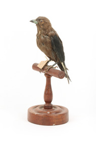
Animal specimen - Dusky Woodswallow, Trustees of the Australian Museum, 1860-1880
... William Street, William Street, NSW, Australia...The Beechworth Burke Museum Loch Street Beechworth high ...The Dusky Woodswallow is often found in flocks which can be located in two separate populations. The Eastern population if located in Atherton Tableland in Queensland south to Tasmania and west to Eyre Peninsula in South Australia. The other population is found in south-west Western Australia. They reside in open forests and woodlands. This species is surprisingly aggressive and may fight with other Woodswallows for territory and nest sights. They will even chase raptors away from their homes. This species flies in flocks of around 10 to 30 birds which cluster together. In terms of diet, these birds eat insects and nectar from flowers. This specimen is part of a collection of almost 200 animal specimens that were originally acquired as skins from various institutions across Australia, including the Australian Museum in Sydney and the National Museum of Victoria (known as Museums Victoria since 1983), as well as individuals such as amateur anthropologist Reynell Eveleigh Johns between 1860-1880. These skins were then mounted by members of the Burke Museum Committee and put-on display in the formal space of the Museum’s original exhibition hall where they continue to be on display. This display of taxidermy mounts initially served to instruct visitors to the Burke Museum of the natural world around them, today it serves as an insight into the collecting habits of the 19th century.This specimen is part of a significant and rare taxidermy mount collection in the Burke Museum. This collection is scientifically and culturally important for reminding us of how science continues to shape our understanding of the modern world. They demonstrate a capacity to hold evidence of how Australia’s fauna history existed in the past and are potentially important for future environmental research. This collection continues to be on display in the Museum and has become a key part to interpreting the collecting habits of the 19th century.The Dusky Woodswallow has largely deep brown colouring with some areas of grey on the head, neck and chest. There is a deeper brown colouring between the wings on the back of the specimen and the wings are black. This bird has a small curved bill which is grey and white. The legs are dark grey and the bird has long talons with an extra long toe in the centre. The eyes are made of brown glass with a back pupil. The bird is styalised standing on a wooden mount and has a paper identification tag attached to its right leg.[torn] / 9 /taxidermy mount, taxidermy, animalia, burke museum, beechworth, australian museum, skin, reynell eveleigh johns, bird, australian birds, swallow, woodswallow, dusky woodswallow -
 Orbost & District Historical Society
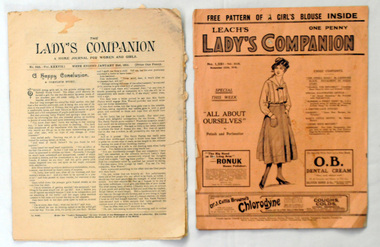
magazines, The Lady's Companion, 21.1.1911 ; 25,11,1916
... Fleet Street ; Exmoor Street, London, United Kingdom...Orbost & District Historical Society Ruskin Street Orbost ...Women's magazines developed rapidly through the 1800's reflecting marketing and social changes. Publications evolved from being journals aimed at the middle class to cheaper, chattier more domestic magazines more widely available. Alice Letitia Swan was the daughter of Edward Swan (tinsmith and plumber at Orbost) and Emma Dinah Jefferson. Alice married Herman Oswald (Ossie) Wehner (blacksmith, Orbost) on 4-4-1923. She was born in 1899 in Omeo and died 14-6-1979, aged 80 in Orbost.(info. from John Phillips)These are early 20th century examples of English women's magazines. They give practical advice on needlework and they evidence the widespread interest in contemporary fashion. In doing so they show what were the fashionable, but broadly affordable, women's and children's clothing styles of their day. These magazines also reflect women's interests in fiction at that time.Two magazines, titled The Lady's Companion. 2424.1 was printed on 21.1.1911 and cost one penny. 2424.2 is dated 25.11.1916 and is titled Leach's Lady's Companion and has a pink cover. Both contain illustrations of the current fashions, interesting facts and selected fiction. 2424.2 : on back in red pen - Miss Alice Swan Nicholson St Orbostwomen's-magazines lady's-companion swan-alice -
 The Beechworth Burke Museum
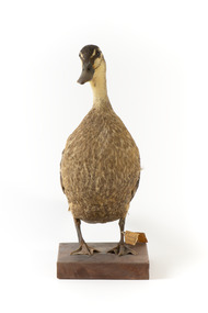
Animal specimen - Pacific Black Duck, Trustees of the Australian Museum, 1860-1880
... William Street, William Street, NSW, Australia...The Beechworth Burke Museum Loch Street Beechworth high ...The Pacific Black Duck is also known as the Grey Duck in New Zealand. Despite these names, the plumage of the bird is brown in colour with the occasional cream and small amount of black. This species of Duck is located in all of Australia with the exception of the most arid zones. They can also be found throughout the Pacific region. The Pacific Black Duck resides in a range of different habitats that have some sort of water. These birds feed on aquatic plants, crustaceans, molluscs and aquatic insects. To catch their food, these birds plunge their heads and necks under the water with their rear raising above the top of the water. This technique is termed "dabbing". This specimen is part of a collection of almost 200 animal specimens that were originally acquired as skins from various institutions across Australia, including the Australian Museum in Sydney and the National Museum of Victoria (known as Museums Victoria since 1983), as well as individuals such as amateur anthropologist Reynell Eveleigh Johns between 1860-1880. These skins were then mounted by members of the Burke Museum Committee and put-on display in the formal space of the Museum’s original exhibition hall where they continue to be on display. This display of taxidermy mounts initially served to instruct visitors to the Burke Museum of the natural world around them, today it serves as an insight into the collecting habits of the 19th century.This specimen is part of a significant and rare taxidermy mount collection in the Burke Museum. This collection is scientifically and culturally important for reminding us of how science continues to shape our understanding of the modern world. They demonstrate a capacity to hold evidence of how Australia’s fauna history existed in the past and are potentially important for future environmental research. This collection continues to be on display in the Museum and has become a key part to interpreting the collecting habits of the 19th century.Despite its name, the Black Duck is largely brown in colouring. It has a mixture of light brown and cream plumage on the neck, face and stomach. The wings and rear of the duck are a darker brown. Each brown feather is bordered with a cream colour which separates the feathers from each other. The top of the head is also dark brown and there is a darker stripe of black colour horizontally on either side of the eye. The specimen has two brown and black glass eyes and a black bill. The legs and webbed feet are a dark brown and black colour. Tied around the left leg is a paper identification tag. The number 134 is inscribed on the left side of the wooden platform on which the bird is standing. This specimen is stocky.3a. / Australian Wild Duck / See Catalogue, Page 38. /taxidermy mount, taxidermy, animalia, burke museum, beechworth, australian museum, skin, reynell eveleigh johns, bird, australian birds, duck, pacific black duck, grey duck, australian duck -
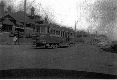 St Kilda Historical Society
Photograph, Railway Tram, c. 1950s?
... Barkly Street Carlisle Street, St Kilda, Victoria... Carlisle Street St Kilda melbourne Railway Tram travelling south ...black and white photograph laminatedRailway Tram travelling south in Barkly St, St Kilda at Carlisle St corner -
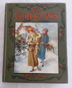 Mont De Lancey
Book, The Girl's Own Annual, 1924
... 4 Bouverie Street, Fleet Street, London, England, Great ...The contents of the book are for girls and women with stories, knitting and sewing patterns, handy home hints, factual information and more. There is an emphasis on Royal Family life.A large thick, heavy green hardcover Girl's Own Annual Volume 46 with a large square picture depicting two women walking in the snow holding bunches of holly. The title is in red print and there is holly surrounding the illustration. The spine has the title printed in gold lettering, holly leaves and Vol 46 in black type at the bottom. It is a 1924 edition of this series. The end papers show green tinted woods and a stream. The coloured frontispiece is of a woman decorating a Christmas Tree from the story - The Christmas Fairy. Tissue paper protects this page. The contents of the book are for girls and women with stories, knitting and sewing patterns, handy home hints, factual information and more. There is an emphasis on Royal Family life. Inside is a 1997 religious bookmark for a Ekankar Seminar, Brisbane Australia. A bookplate is pasted at the front of the book. non-fictionThe contents of the book are for girls and women with stories, knitting and sewing patterns, handy home hints, factual information and more. There is an emphasis on Royal Family life.books, children's books, awards, adventure stories, family life fiction, family life -
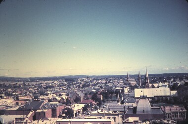 Bendigo Historical Society Inc.
Slide - BENDIGO & EASTER FAIR, 1963
... street and Forest Street, church in Forest Street in slide.... Inc. History House 11 Mackenzie Street Bendigo goldfields ...View from Rosalind Park tower looking south across View street and Forest Street, church in Forest Street in slide.slide, bendigo, city view -
 Bacchus Marsh & District Historical Society
Map, Atkins and Clarke Land Sale situate at Bacchus Marsh 1856 Copy 2
... indicate the name Crook Street on the map. As the Crook family were.... The land for sale is bounded by the present day streets of Main... indicate the name Crook Street on the map. As the Crook family were ...This plan of land allotments for sale indicates the property once owned by the Bacchus family in and around the township area of Bacchus Marsh. The Bacchus family sold their property in Bacchus Marsh to John Atkins and Robert Nalder Clarke in March 1851. Atkins and Clarke kept the property for a number of years until April 1856 when these allotments were put up for sale.This plan is almost identical to another copy held by the Bacchus Marsh and District Historical Society, VC Record 707, BMDHS collection). This plan, VC Record 452 Copy 2, contains a less detail than than VC Record 707 Copy 1. For example the selling agents and the surveyor who created the plan are not indicated on this copy of the plan. This copy of the plan does indicate the name Crook Street on the map. As the Crook family were the buyers of the Manor House property and surrounding land from Atkins and Clarke in 1856 it suggests that this copy is a later one of the earlier version. It is unlikely that the Crook family would have had the adjacent street named after them prior to purchasing the house and property. This is a very early land sales plan for the township of Bacchus Marsh and it therefore provides some clues as to how the early urban development of the township took place. Upon seeing the map in 1911 Bacchus Marsh Express newspaper editor Christopher Crisp wrote "The sale appears to have created the present township, which had a nucleus in earlier times further east", Express, 30 September, 1911, page 3. A single page paper map showing a portions of land available for sale in Bacchus Marsh in 1856. The subdivided land shown was owned by John Atkins and Robert Nalder Clarke, but previously owned by the Bacchus Family and was in and around their Manor House (Mansion) property in Bacchus Marsh.There are 5 portions of land further divided into numerous small portions. The land for sale is bounded by the present day streets of Main Street, Young Street, McFarland Street, Morton Streets, Crook Street, and part of the eastern section extends to the Lerderderg River. Scale: 4 chains to 1 inch. The map is pasted into a bound volume containing 76 maps or plans in total. High resolution digital image stored on BMDHS computer network. Plan of the first portion of land. The property of Messers Atkins and Clarke situate at Bacchus Marsh.land sales, land sales bacchus marsh, manor house bacchus marsh, crook family bacchus marsh -
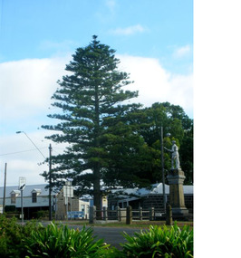 Mortlake and District Historical Society
The Peace Tree
... Street, Shaw Street and Jamieson Avenue intersection.... Centre 27 Shaw Street Mortlake great-ocean-road This Norfolk ...This Norfolk Island pine tree was planted in 1919 as 'The Peace Tree'. A community gesture signifying the embrace of 'peace' as a valuable concept symbolised by the planting of a tree. [from Mortlake Dispatch] PEACE DAY 1919. Throughout the Empire three days were marked as Public Holidays including Peace Day in July 1919. Mortlake observed Peace Day by Peace Medals being distributed at the State School, Union Jacks being flown from many buildings and houses and the Peace Tree being planted at the intersection of Officer Street, Jamieson Avenue and Shaw Street. Then followed a procession [of local people]. It is assumed the Progress Association, which undertook the Avenue of Honour, also was responsible for planting the Peace Tree. Norfolk Pine tree located on eastern corner of Officer Street, Shaw Street and Jamieson Avenue intersection.1919, peace, norfolk island pine -
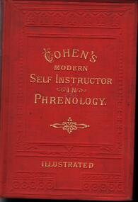 Bendigo Historical Society Inc.
Book - COHEN'S MODERN SELF INSTRUCTOR IN PHRENOLOGY
... Street & Kings Street, Huddersfield.... Inc. History House 11 Mackenzie Street Bendigo goldfields ...271 page hardcover titled 'The Modern Self Instructor in Phrenology, Physiognomy and physiology or The Peoples Hand book of Human Nature. Red in colour with gold print.The first page is yellow paper which has a hand written note in black ink which reads: 'Presented to Henry Gough by his teacher A. Hampson for obtaining the highest number of marks during 1887 in his class at St. Paul's Sunday School dated 1/04/88. The book is Cohen's view into the mind, body, and sole of human beings.Gustavus Cohen. George Whitehead & Sons, Printers, New Street & Kings Street, Huddersfield.medicine, mental health, phrenology, henry gough, a. hampton -
 Robin Boyd Foundation
Slide, Robin Boyd, 1950
... Colour slide in a mount. Street in Hatfield, Hertfordshire...England Street (Handwritten) / Street in Hertfordshire...Robin Boyd Foundation 290 Walsh Street South Yarra ...Penleigh Boyd, Robin and Patricia Boyd's son, writes “Prior to 1950 Robin, like most other amateur or hobby photographers, took black and white printed photographs. The oldest slides date from 1950 when Robin and Patricia travelled to Europe on Robin’s Robert Haddon Travelling Scholarship.” In 1948 Robin Boyd was awarded ‘joint first place’ in the Robert Haddon competition for his design of Mildura art gallery. The scholarship helped fund their first overseas trip. Robin and Patricia were passengers on the Greek ship “Cyrenia” departing in May 1950, passing through the Suez Canal and landing in Genoa five weeks later. For six months, they travelled extensively throughout Europe (predominantly driving themselves) - France, Italy, United Kingdom, Sweden, Denmark, Germany, Austria, Switzerland and Spain.Colour slide in a mount. Street in Hatfield, Hertfordshire, leading to Hatfield House, Hatfield, EnglandEngland Street (Handwritten) / Street in Hertfordshire Leading to Hatfield House (Marquess of Salisbury) (Handwritten)haddon travelling scholarship, haddon, robin boyd, slide -
 Bacchus Marsh & District Historical Society
Map, Maddingley Township, Parish of Parwan, County of Grant, 1856
... on this map is an area bounded by Bacchus Street, Moore Street...A single page paper map showing land allotments, streets... on this map is an area bounded by Bacchus Street, Moore Street ...Maddingley is a locality or township within the broader township area of Bacchus Marsh. This map is dated 1856 but is based on an earlier survey in 1843. The main area of Maddingley shown on this map is an area bounded by Bacchus Street, Moore Street, Griffith Street and Franklin Street. Other streets visible are Inglis Street, Labilliere Street, McCrae Street. The area to the east of Franklin Street is not sub-divided and is described as an 'alluvial flat. A single page paper map showing land allotments, streets, and natural watercourses in the township of Maddingley. The map is pasted into a bound volume containing 76 maps or plans in total. Two inscriptions: 1. A.J. Skene Surveyor, 1843. ; 2. Surveyor-General's Office Melbourne, Sept 6, 1856. (Lithographed by R. Meikle)bacchus marsh victoria maps, maddingley victoria maps, land use, maddingley victoria history -
 Surrey Hills Historical Society Collection
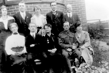
Photograph, Davis, Johns and Street families in Surrey Hills, c1919
... Davis, Johns and Street families in Surrey Hills, c1919...lightfoot street... a home in Scheele Street and lived there until he was promoted... a home in Scheele Street and lived there until he was promoted ...Identification provided by the donor, Mrs Ruth Edgar (nee Johns), as follows: Back row - L to R: Miss Hilda Davis (later Mrs F A McLaughlin), of 16 Valonia Avenue, aged 103 in 1995 and the only one in the photo then alive; E Murray Johns, eldest son of Rev and Mrs Wesley Johns of Mont Albert; he married and built a home in Scheele Street and lived there until he was promoted to Head Office of the Bank of NSW; brother of the donor; Miss Ethel Street from Wodonga, daughter of Mrs Theresa Street in the front row; an unidentified friend; Mr Walter E Davis, Manager of the Telegraph Branch of the G.P.O. and a keen member of the Surrey Hills Bowling Club, owner of 40 Windsor Crescent and an active member of the Surrey Hills Methodist Church. Front row - L to R: Mrs W E Davis, sister of E J Nuttall of Surrey Hills, one of the co-designers of the Australian flag; W Lyndon Davis, son of Mr & Mrs W E Davis, who built and lived in Lightfoot Street; Mrs Theresa Street from Wodonga, sister of Mr W E Davis & Mrs Wesley Johns; Mr Walter Street, son of Mrs T Street, newly returned from WW1 with his young English bride, Helen. Walter Edwin Davis - born 1858, married Bertha Amy Nuttall / Davis (1864-1941) in 1889. Walter Lyndon Davis (1895-1970) Ruth Lilian Johns (1911-2004) daughter of Wesley Johns & Elizabeth Davis. The photo was enlarged & reprinted from a 75 year-old photo 2 inches by 3 inches by a local firm "Think Negative" in Mont Albert. A black and white photograph of 5 women and 5 men assembled in a group in the garden of a building. One man is in uniform, the other men are wearing suits. The ladies are wearing long skirts.valonia avenue, windsor crescent, lightfoot street, world war, 1914-1918, helen (mrs), mr e murray johns, rev wesley johns, scheele street, miss ethel street, mrs w e davis, miss bertha amy nuttall, walter lyndon davis, walter edwin davis, miss hilda davis, mrs frederick arthur mclaughlin, mrs theresa street, miss theresa emily davis, miss elizabeth davis, mrs elizabeth johns, walter frederick street, mrs helen swtreet, miss helen hewlett, ernest murray johns -
Whitehorse Historical Society Inc.
Article, Top policeman's efforts rewarded, 3/02/1993 12:00:00 AM
... He played an integral role in the Russell Street bombing... in the Russell Street bombing, Walsh Street shootings and 'Mr Stinky... Mitcham melbourne He played an integral role in the Russell Street ...Chief Superintendent Kevin Holliday was awarded an Australian Police Medal awarded for distinguished service in the Australia Day honours list.Chief Superintendent Kevin Holliday was awarded an Australian Police Medal awarded for distinguished service in the Australia Day honours list. He played an integral role in the Russell Street bombing, Walsh Street shootings and 'Mr Stinky' Raymond Edwards.Chief Superintendent Kevin Holliday was awarded an Australian Police Medal awarded for distinguished service in the Australia Day honours list. holliday, kevin, police -
 City of Kingston
Pamphlet - Colour, Fergusson & Mitchell Lith, Sandringham Rises, c. 1888
... by Bluff Road, Bay Road and William Street, and incorporating... by Bluff Road, Bay Road and William Street, including Frances... by Bluff Road, Bay Road and William Street, and incorporating ...Sales plan for land in the suburb of Sandringham, bounded by Bluff Road, Bay Road and William Street, and incorporating Frances Street.The developing urban area of Highett (then called Sandringham) within the City of Kingston. This land sale pamphlet illustrates the subdivision of land within the municipality and the changing demographic of the district as new houses are constructed close to infrastructure.Colour pamphlet advertising for sale 35 lots in Sandringham Rises, Sandringham. Incorporates a map of the estate bordered by Bluff Road, Bay Road and William Street, including Frances Street.Handwritten in grey pencil next to the words 'THREE O'CLOCK': 1888 Handwritten in blue ben next to the words '& BUSINESS SITES': 1888land sales, sandringham, highett -
 Ringwood and District Historical Society
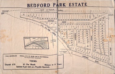
Plan - Sub-division, Bedford Park Estate, Ringwood, Victoria - 1924
... Street, Anderson Street, and Adams Street. Solicitors - W.R.R... Bedford Road, Graham Road, Joyce Street, Anderson Street ...Bedford Park subdivisional development did not eventuate. The land adjoining the railway line became parkland with provision for sporting facilities and the remainder was purchased by the Education Department as the site for Ringwood High School/Secondary College. Poster size land sale advertisement.Subdivision plan includes Bedford Road, Graham Road, Joyce Street, Anderson Street, and Adams Street. Solicitors - W.R.R. Blair, Son & Falconbridge, 405 Collins Street, Melbourne. -
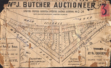 Ringwood and District Historical Society
Poster - Land Sale, Wm J. Butcher, Auctioneer - Albert Park Estate, Ringwood - c.1890
... Dandenong Road), Joseph Street, Dynes Street, Albert Street (later...Solicitors - Jenningw & Wright, Queen Street. Surveyors...Solicitors - Jenningw & Wright, Queen Street. Surveyors - J ...Central section of land sale subdivision advertisement glued to heavy cardboard backing. Photocopied SLV image of original advertisement shows map of 117 allotments for sale in Main Lilydale Road (later Old Lilydale Road), Wandin Road (later Mount Dandenong Road), Joseph Street, Dynes Street, Albert Street (later Wyrunga Street) and Government Road (later Carcoola Road), Ringwood East.Solicitors - Jenningw & Wright, Queen Street. Surveyors - J.&H. Tarrant, Elizabeth Street. Terms £2 10s cash deposit, balance three years at six per cent. -
Port Melbourne Historical & Preservation Society
Plan - Fencng, Sandridge, Engineering Department, Borough of Sandridge, 1879
... Design for fencing Block 19 (bounded by Lyons Street... Melbourne Town Hall 333 Bay Street Port Melbourne melbourne ...Design for fencing Block 19 (bounded by Lyons Street, Liardet Street and Esplanade West), Borough of Sandridge, 1879Signed by R Gabell (7-4-1879) and Chas. Clay, Surveyor (15-3-1879) and E. Clark, Town Clerk (14-4-1879):"Contract No. 355"engineering - fences, edward clark, town clerks, charles clay, r gabell -
 Camberwell Historical Society
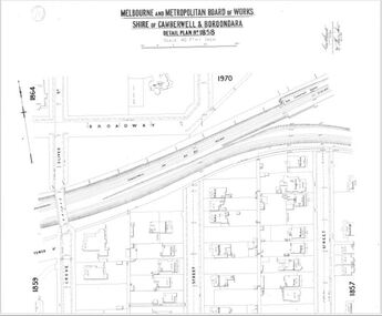
Map (Item) - MMBW map, Melbourne and Metropolitan Board of Works, Melbourne and Metropolitan Board of Works - Shire of Boroondara and Camberwell - Detail Plan no. 1858, August 1904
... MMBW Detail Plan showing Kingsley Street, Moorhouse Street.... MMBW Detail Plan showing Kingsley Street, Moorhouse Street ...Lithographer E.H.H., Exd J.W.D, Aug 1904, No. 103. 40P.15W.melbourne and metropolitan board of works, map, camberwell, cartography -
 Bendigo Historical Society Inc.
Document - MCCOLL, RANKIN AND STANISTREET COLLECTION: GOLD MINING LEASE NORTH DEBORAH MINING COMPANY, 6th May, 1941
... . Streets: Sullivan Street, Hargreaves Street, Violet Street, Queen... Mine J Stanistreet Sullivan Heargreaves Queen King Streets. 6 ...6 page indenture document plus plan, between King George VI and North Deborah Mining company, no liability, Parish of Sandhurst, dated 6th May 1941. Lease number 11146 Bendigo. ' all that piece of land above a depth of one hundred feet below the surface of the land delineated and coloured yellow' Signed by J. Stanistreet, manager. Plan shows excised area in pink. Excised below 100ft shown in yellow ( lease 11146 ) On top of plan ' Mining district of Bendigo, County of Bendigo, Parish of Sandhurst. Area section has been amended to show 1 rood, 14 perches. Leases on plan : No. 9988, 11013, 11062, 11033, 11146, 10753, 11020. Streets: Sullivan Street, Hargreaves Street, Violet Street, Queen Street, King Street. Railway line shown. Scale 8 chains to 1 inch.bendigo, mining, north deborah mining company, north deborah mine, j stanistreet, sullivan heargreaves, queen, king streets. -
 Bacchus Marsh & District Historical Society
Map, Maddingley Township, Parish of Parwan, circa 1890s
... by Bacchus Street, Barry Street, Griffith Street and Maddingley Road...A single page paper map showing land allotments, streets... by Bacchus Street, Barry Street, Griffith Street and Maddingley Road ...Maddingley is a locality or township within the broader township area of Bacchus Marsh. This map is not dated. However features in Maddingley which appeared in the 1880s and 1890s are present in the map, These include the Bacchus Marsh Railway Station and the Bacchus Marsh Showgrounds. The main residential and commercial area of Maddingley is shown on this map in an area bounded by Bacchus Street, Barry Street, Griffith Street and Maddingley Road. Other streets visible are Franklin Street, Inglis Street, Labilliere Street, McCrae Street, Moore Street and part of Station Street.A single page paper map showing land allotments, streets, rivers, creeks, park lands, the railway line and Bacchus Marsh railway station in the township of Maddingley. The map is pasted into a bound volume containing 76 maps or plans in total. bacchus marsh victoria maps, maddingley victoria maps, land use, maddingley victoria history -
Port Melbourne Historical & Preservation Society
Plan - Traffic census, Port Melbourne, 6 Mar 1947
... at Ingles Street and Williamstown Road (no 84), Lorimer Street... Melbourne Town Hall 333 Bay Street Port Melbourne melbourne ...Traffic census 6th March 1947 showing intersections at Ingles Street and Williamstown Road (no 84), Lorimer Street and Salmon Street )no 90) Beach Street and Bay Street (no 113) Williamstown Road and Beach Road (no 112), Railway Crossing Graham Street (no 77)engineering - roads streets lanes and footpaths -
Bendigo Historical Society Inc.
Document - Hustler Mine Sites
... ft. Great Extended Hustlers Great Extended Streets... ft. Great Extended Hustlers Great Extended Streets ...One page photocopy: section of a mining map, showing contour lines and mine locations of the following mines: Hustlers Royal Reserve 1775 ft Park Shaft Royal Hustlers Shaft 1150 ft Imperial Hustlers Shaft Hustlers Extended Hustler Trib Shaft 1970 ft. Great Extended Hustlers Great Extended Streets on the map: Barkly Street, Drought Street, Rosalind Street and Hope Street.