Showing 27608 items
matching yarra-river
-
 Greensborough Historical Society
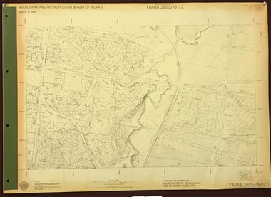
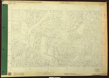
Map, Melbourne and Metropolitan Board of Works. Survey Division, MMBW, Yarra 2500 / 15.22. Eltham North. Allendale Road, 1979_08
Melbourne and Metropolitan Board of Works. Yarra 2500 [base map] 15.22. Eltham North, Allendale Road. Parish of Nillumbik. Municipalities of Eltham 238 and Diamond Valley 257. Prominent streets include: Allendale Road, Godber Road and Ryans Road. Features include the Diamond Creek.MMBW Map in 1:2500 [scale] series. Cream parchment with green tape reinforcing on edges and punched holes on left edge.mmbw, melbourne and metropolitan board of works, shire of diamond valley, nillumbik, eltham - maps -
 Greensborough Historical Society
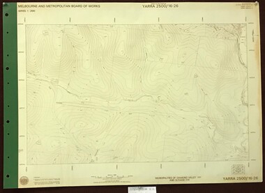
Map, Melbourne and Metropolitan Board of Works. Survey Division, MMBW, Yarra 2500 / 16.26. Diamond Creek, Broadgully Road, 1978_07
Melbourne and Metropolitan Board of Works. Yarra 2500 [base map] 16.26. Diamond Creek, Broad Gully Road. Municipalities of Diamond Valley 257 and Eltham 238. Prominent streets include: Wadeson Road, Broad Gully Road and Glenhaven Road. Features include the Diamond Creek.MMBW Map in 1:2500 [scale] series. Cream parchment with green tape reinforcing on edges and punched holes on left edge.mmbw, melbourne and metropolitan board of works, shire of diamond valley, diamond creek - maps -
 Melbourne Tram Museum
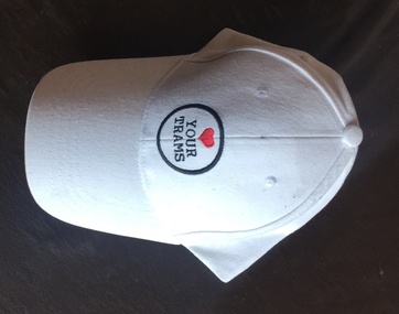
Uniform - Cap, Yarra Trams, c2010
White baseball style cap, with a "Love your trams" symbol on the front and "Yarra Trams" logo on the rear. Velcro strap on rear. Sew with white cotton, button on top, stiff card peak to the cap.trams, tramways, cap, yarra trams -
 Greensborough Historical Society
Photograph - Digital image, Frank Robinson, Willows in the Plenty River, looking south west to cliffs, 1954_
Willows in the Plenty River, looking south west to cliffs. The Blackjack property, house and acres of fruit orchards ran down to the Plenty River off Hume Street Greensborough and was the home of the Robinson family to late 1956. The photographs were taken as slides by Frank Robinson and digitised by his son James in 2015. Oral history has it that Anthony Beale was the first to bring willow cuttings from the island of St Helena, to Australia.Digital copy of colour photograph.robinson family, blackjack, plenty river -
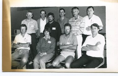 Orbost & District Historical Society
black and white photograph, Snowy River Mail, October 1987
This a photograph of the Gippsland representatives at the C.A.T.S. conference. This photograph was taken at the Curriculum and Technology in Schools workshop held in Bendigo, Victoria in October 1987. Eighty rural primary schools were involved including many from East Gippsland. From the Snowy River Mail; " A large number of technologies was......demonstrated at the conference. Participants were given hands on experience with audio and computer conferencing, CD Rom. an Invicon booth ( individual video console (INVICON) enables any teacher to produce short, relevant teaching videos for individual pupils without assistance), packet radio, videodisk, robotics and many more...." In the back row are: Al Balfour (Bairnsdale Min of E); Graeme Rodier (OHS); Roger Nink (Swifts Creek); John Hillier (Mallacoota); Barry Lay ( Bairnsdale HS); Ross Burn ( Bairnsdale HS), In the front row are: Jeff Wilson (Mallacoota); Bea Lay (Bairnsdale HS); Rick Box ( Swifts Creek) and Brian Pomeroy (AVRB Bairnsdalel). Al Balfour was a noted educator, local identity and one of country Victoria's strongest advocates.This is a pictorial record associated with education in East Gippsland.A black / white photograph of a group of people. The back row is standing and the front is sitting on chairs.education-east-gippsland technology -
 Melbourne Tram Museum
Document - Folder with papers, Yarra Trams, "M>Tram Q&A pack", Feb. 2004
Set of seven press releases and other information documents contained within a white card board folder marked ""M>Tram Q&A pack" issued at the time Yarra Trams entered into the new partnership arrangement to merge M>Tram operations into Yarra and operate a single tram network. Has a M>Tram logo on the front cover. All dated 19/2/2004 unless otherwise noted and all A4 size on white paper. .1 - folder with following papers: .2 - Single page letter from Des Davies Manager Human Resources Yarra Trams to all M>Tram staff. .3 - single page letter from Colin Nicol and Peter Anderson Receivers of M>Tram at KPMG to all M>Tram, M>Train and Bayside Maintenance staff. .4 - Media Release from Connex group, 2 pages, "Connex Awarded Melbourne Train Franchise" with Veolia and Connex logos. .5 - Media release from Yarra Trams, 4 sheets, 7 pages, from Yarra Trams "Yarra Trams services to expand across the entire Melbourne Tram network" .6 - Media release from the Premier of Victoria - 5 sheets including two fact sheets - "Stability returns to State's tram and train system" .7 - M>Tram "Staff Update - Refranchising Announcement" - two pages - signed by Bernie Carolan .8 - DL size three fold pamphlet, "New Public Transport Partnerships" published by Victorian Government Dept. of Infrastructure, with message from Peter Batchelor, Minister for Transport.trams, tramways, yarra trams, m>tram, victorian government, transport, press release, media release, connex -
 Federation University Historical Collection
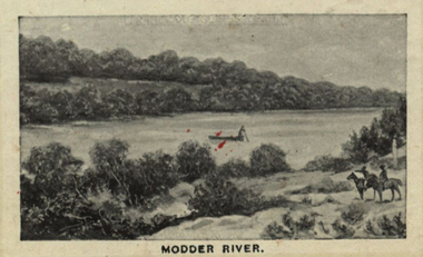
Photograph (black & White), Modder River - South Africa
When war broke out in 1899, and early target for the Boers was the diamond-mining centre of Kimberley. This was located near the point where the Transvaal, Orange Free State and Cape Colony met. General Sir Redvers Buller detached the 1st Division under Lieutenant General Lord Methuen to relieve the Siege of Kimberley. This decision was made partly for reasons of prestige. To capture Kimberley (which contained the famous imperialist and former Prime Minister of Cape Colony, Cecil Rhodes) would be a major propaganda victory for the British. Methuen's force advanced north and won two engagements against the Boers of the Orange Free State. Reinforcements from Transvaal under General Koos de la Rey arrived and he convinced the Boers to follow his plans for attacking the British. Instead of relying on the hills for protection and missing their targets, de la Rey proposed they make use of the flat veld and introduced them to the Mauser rifle with its flat trajectory. Trenches were built in the banks of the Modder River from which they could sweep the veld for a great distance. The trenches were built on the south side of the river and on the smaller Riet River where they meet at Modder River Station. Methuen's force began advancing towards the Modder planning to cross the river. The Boers opened fire and the British troops were unable to find cover on the veld. They had to lay flat so as not to be seen or hit. The British guns pounded the buildings near Modder River Station and the north bank of the river, missing the trenches on the south bank. The battle became a stalemate. The British found an opening on the Boer's right flank at Rosmead ford downstream and drove the Boers out of Rosmead. De la Rey drove them back into a small insecure bridgehead. The Boers feared they were vulnerable and withdrew during the night. Methuen reported that the battle had been "one of the hardest and most trying fights in the annals of the British army". Individual image from photographed poster of tobacco and cigarette cards.boers, diamind-mining, kimberley, transvaal, orange free state, cape colony, sir rdvers buller, lieutenant general lord methuen, siege of kimberley, cecil rhodes, general koos dde la rey, mauser rifle, veld, modder river, modder river station, trenches, riet river, rosmead -
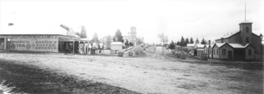 Yarra Glen & District Historical Society
Black and white photographs, Bell Street Yarra Glen looking north c.1900
View of Bell Street Yarra Glen looking north from junction with King Street. On left hand side is Scott & Allen's General Store, next to that is a bootmaker, then the house of Charles Bath, the Grand Hotel and the Colonial Bank building. On the eastern side of Bell Street (right hand side of photograph) is the Victoria Hall. Beyond that is W.J.Dawborn's General Store, then Smith's bakery, and on top of the hill the trees surrounding 'Point Pleasant' owned by the Herbert family.yarra glen, point pleasant, grand hotel, victoria hall, bell street, charles bath, general store, colonial bank, bank building, w j dawborn, scott and allen, bootmaker, smith, bakery, baker s shop, herbert -
 Greensborough Historical Society
Article, Anne Paul, History of the Plenty River Pioneer Children's Cemetery, by Anne Paul, 2012_12
Unmarked graves of the seven children of the Whatmough and Partington families who died between 1848 and 1860 are in a private cemetery on the east bank of the Plenty River1 p., text with colour photographspioneer childrens cemetery, anne paul, whatmough family, partington family, cemeteries -
 Greensborough Historical Society
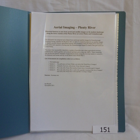
Folder, Aerial Imaging - Plenty River: by Ian Bryant, 2011_11
Investigates early land use along the Plenty River from north of the main aqueduct crossing in Greensborough to south of the golf course in Lower PlentyHistorical features seen from aerial and satellite images of the modern landscape may indicate earlier agricultural land usage.9 x A4 pages of text and colour annotated maps downloaded from nearmap.com.plenty river, ian bryant, lower plenty, greensborough, yallambie park, aerial photography -
 Greensborough Historical Society
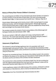
Article, History of Plenty River Pioneer Children's Cemetery by Anne Paul, 1848-1860
The Plenty River Pioneer Children's Cemetery contains unmarked graves of children from the Whatmough and Partington families who died between 1848 and 1860.The cemetery's significance lies in its connection with two of Greensborough's pioneer families. 4 pages, text and photographs.plenty river pioneer childrens cemetery, anne paul, partington, whatmough -
 Greensborough Historical Society
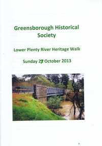
Booklet, Lower Plenty River Heritage Walk Sunday 27 October 2013, 27/10/2013
This booklet was used during the Heritage Walk along the Lower Plenty River in October 2013. It outlines natural and built landscapes of interest along this trail. 24 pages, illus. (some col.), maps.lower plenty, plenty river, lower plenty river heritage walk -
 Greensborough Historical Society
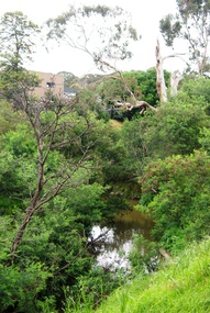
Photograph - Digital Image, Marilyn Smith, Plenty River near Willinda Park, 06/11/2017
This group of photographs shows the Plenty River adjacent to Willinda Park. Willinda Park is situated in Beatrix Street Greensborough and has an athletics track and field. Digital copy of colour photographswillinda park, beatrix street greensborough, athletics, plenty river -
 Greensborough Historical Society
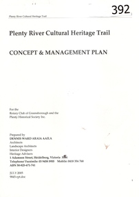
Report, Plenty River Cultural Heritage Trail : Concept & management plan, 2005_07
Prepared for the Rotary Club of Greensborough and Plenty Historical Society by Dennis Ward, this report outlines the heritage importance of the Plenty River Trail around Greensborough.This is an ongoing project by Dennis Ward. This report is an early version of the 2011 Squatters, speculators and settlers: Plenty River Cultural heritage trail. (Item 258) 66 page report, Illus, (some col.) , maps. In red 2-ring binder.Some handwritten notes in last pages.plenty river cultural heritage trail, dennis ward, rotary club of greensborough, plenty historical society, plenty river -
 Malmsbury Historical Society
Photograph (Item), Two Men Fishing In A River (Coliban?), Malmsbury c1900
People - "Townsend, E; Hall, Percy; Smith, W. H. (Photographer)" Buildings - River (Coliban?) Associated with - "Smith, W.H. (Photographer); Bank Of Victoria" -
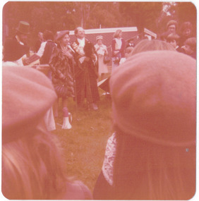
 Kew Historical Society Inc
Photograph - Historic re-enactment during the Festival of Kew, 1978
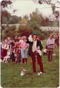
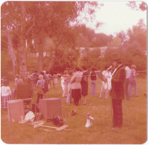
At the 1978 Festival of Kew, a number of organisations, including the City of Kew, the Kew Historical Society, Trinity Boys Grammar School and local Girl Guides participated in a re-enactment of the expedition of the party of Charles Grimes in surveying the Yarra River as far as Kew in February 1803. The location for the event was Yarra Bend Park near the Studley Park Boat House. The event was organised by the Kew Historical Society. The re-enactment was captured by a number of amateur photographers as well as by a photographer from the local Progress Press.Local communities select events to commemorate according to their shared history and values. Commemorations of colonial exploration were popular with local historical groups such as the Kew Historical Society in the twentieth century. In re-enacting events such as the Grimes survey of the Yarra, students from a local school were encouraged to take on specific roles, including play-acting individuals involved in the survey party as well as members of the local Wurundjeri People. The photographs, taken by amateur and professional photographers, represent a period in time when the dominant values were those shared by the descendants of European settlers in Victoria. Original colour photographic positive of Cr Allan Hutchinson, role-playing a town crier in the re-enactment.Annotated on reverse: "CR ALLAN HUTCHINSON AS TOWN CRIER, RE-ENACTMENT OF GRIMES' JOURNEY 1803 / KHS CONTRIBUTION TO FESTIVAL OF KEW 1978 / TAKEN BY S. WEST"kew historical society, trinity grammar school, kew girl guides, city of kew, yarra river, charles grimes, collins expedition, wurundjeri people, yarra bend park, colonial surveys, historic re-enactments, festival of kew, kew festival, cr allan hutchinson -
 Kew Historical Society Inc
Photograph - Historic re-enactment during the Festival of Kew, 1978
At the 1978 Festival of Kew, a number of organisations, including the City of Kew, the Kew Historical Society, Trinity Boys Grammar School and local Girl Guides participated in a re-enactment of the expedition of the party of Charles Grimes in surveying the Yarra River as far as Kew in February 1803. The location for the event was Yarra Bend Park near the Studley Park Boat House. The event was organised by the Kew Historical Society. The re-enactment was captured by a number of amateur photographers as well as by a photographer from the local Progress Press.Local communities select events to commemorate according to their shared history and values. Commemorations of colonial exploration were popular with local historical groups such as the Kew Historical Society in the twentieth century. In re-enacting events such as the Grimes survey of the Yarra, students from a local school were encouraged to take on specific roles, including play-acting individuals involved in the survey party as well as members of the local Wurundjeri People. The photographs, taken by amateur and professional photographers, represent a period in time when the dominant values were those shared by the descendants of European settlers in Victoria. Original colour photographic positive of Cr Allan Hutchinson, dressed as a town crier in the re-enactment.Annotated on reverse: "CR HUTCHINSON 1978 / TOWN CRYER"kew historical society, trinity grammar school, kew girl guides, city of kew, yarra river, charles grimes, collins expedition, wurundjeri people, yarra bend park, colonial surveys, historic re-enactments, festival of kew, kew festival, cr allan hutchinson -
 Kew Historical Society Inc
Photograph - Historic re-enactment during the Festival of Kew, 1978
At the 1978 Festival of Kew, a number of organisations, including the City of Kew, the Kew Historical Society, Trinity Boys Grammar School and local Girl Guides participated in a re-enactment of the expedition of the party of Charles Grimes in surveying the Yarra River as far as Kew in February 1803. The location for the event was Yarra Bend Park near the Studley Park Boat House. The event was organised by the Kew Historical Society. The re-enactment was captured by a number of amateur photographers as well as by a photographer from the local Progress Press.Local communities select events to commemorate according to their shared history and values. Commemorations of colonial exploration were popular with local historical groups such as the Kew Historical Society in the twentieth century. In re-enacting events such as the Grimes survey of the Yarra, students from a local school were encouraged to take on specific roles, including play-acting individuals involved in the survey party as well as members of the local Wurundjeri People. The photographs, taken by amateur and professional photographers, represent a period in time when the dominant values were those shared by the descendants of European settlers in Victoria. Original colour photographic positive of Cr Allan Hutchinson, dressed as a town crier in the re-enactment. Spectators and Kanes Bridge is in the background.Annotated on reverse: "FESTIVAL 1978 / CR ALLAN HUTCHINSON"kew historical society, trinity grammar school, kew girl guides, city of kew, yarra river, charles grimes, collins expedition, wurundjeri people, yarra bend park, colonial surveys, historic re-enactments, festival of kew, kew festival, cr allan hutchinson -
 Kew Historical Society Inc
Photograph - Historic re-enactment during the Festival of Kew, 1978
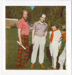
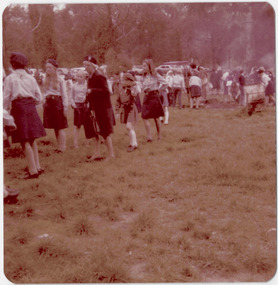
At the 1978 Festival of Kew, a number of organisations, including the City of Kew, the Kew Historical Society, Trinity Boys Grammar School and local Girl Guides participated in a re-enactment of the expedition of the party of Charles Grimes in surveying the Yarra River as far as Kew in February 1803. The location for the event was Yarra Bend Park near the Studley Park Boat House. The event was organised by the Kew Historical Society. The re-enactment was captured by a number of amateur photographers as well as by a photographer from the local Progress Press.Local communities select events to commemorate according to their shared history and values. Commemorations of colonial exploration were popular with local historical groups such as the Kew Historical Society in the twentieth century. In re-enacting events such as the Grimes survey of the Yarra, students from a local school were encouraged to take on specific roles, including play-acting individuals involved in the survey party as well as members of the local Wurundjeri People. The photographs, taken by amateur and professional photographers, represent a period in time when the dominant values were those shared by the descendants of European settlers in Victoria. Original colour photographic positive of from left: Cr Allan Hutchinson, Cr Noel Whiting, Mayor of Kew, and Trinity Grammar boys dressed in sailor costumes.Annotated on reverse: "MAYOR, CR HUTCHINSON AND SAILORS"kew historical society, trinity grammar school, kew girl guides, city of kew, yarra river, charles grimes, collins expedition, wurundjeri people, yarra bend park, colonial surveys, historic re-enactments, festival of kew, kew festival, cr allan hutchinson, cr noel whiting -
 Kew Historical Society Inc
Photograph - Historic re-enactment during the Festival of Kew, 1978
At the 1978 Festival of Kew, a number of organisations, including the City of Kew, the Kew Historical Society, Trinity Boys Grammar School and local Girl Guides participated in a re-enactment of the expedition of the party of Charles Grimes in surveying the Yarra River as far as Kew in February 1803. The location for the event was Yarra Bend Park near the Studley Park Boat House. The event was organised by the Kew Historical Society. The re-enactment was captured by a number of amateur photographers as well as by a photographer from the local Progress Press.Local communities select events to commemorate according to their shared history and values. Commemorations of colonial exploration were popular with local historical groups such as the Kew Historical Society in the twentieth century. In re-enacting events such as the Grimes survey of the Yarra, students from a local school were encouraged to take on specific roles, including play-acting individuals involved in the survey party as well as members of the local Wurundjeri People. The photographs, taken by amateur and professional photographers, represent a period in time when the dominant values were those shared by the descendants of European settlers in Victoria. Original colour photographic positive of the site where the re-enactment of Charles Grimes' survey party of 1803 took place during the Kew Festival of 1978.Annotated on reverse: "GRIMES LANDING SITE / 1978 / DONATED BY MRS DEAN"kew historical society, trinity grammar school, kew girl guides, city of kew, yarra river, charles grimes, collins expedition, wurundjeri people, yarra bend park, colonial surveys, historic re-enactments, festival of kew, kew festival -
 Kew Historical Society Inc
Photograph - Historic re-enactment during the Festival of Kew, 1978
At the 1978 Festival of Kew, a number of organisations, including the City of Kew, the Kew Historical Society, Trinity Boys Grammar School and local Girl Guides participated in a re-enactment of the expedition of the party of Charles Grimes in surveying the Yarra River as far as Kew in February 1803. The location for the event was Yarra Bend Park near the Studley Park Boat House. The event was organised by the Kew Historical Society. The re-enactment was captured by a number of amateur photographers as well as by a photographer from the local Progress Press.Local communities select events to commemorate according to their shared history and values. Commemorations of colonial exploration were popular with local historical groups such as the Kew Historical Society in the twentieth century. In re-enacting events such as the Grimes survey of the Yarra, students from a local school were encouraged to take on specific roles, including play-acting individuals involved in the survey party as well as members of the local Wurundjeri People. The photographs, taken by amateur and professional photographers, represent a period in time when the dominant values were those shared by the descendants of European settlers in Victoria. Original colour photographic positive of the [unhistoric] report by a Trinity Grammar School student, dressed in costume as the surveyor Charles Grimes, reporting to the then Mayor of Kew, Cr Noel Whiting. Wurundjeri warriors are in the foreground. .Annotated on reverse: "GRIMES REPORTING TO MAYOR"kew historical society, trinity grammar school, kew girl guides, city of kew, yarra river, charles grimes, collins expedition, wurundjeri people, yarra bend park, colonial surveys, historic re-enactments, festival of kew, kew festival -
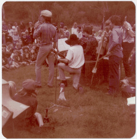 Kew Historical Society Inc
Photograph - Historic re-enactment during the Festival of Kew, 1978
At the 1978 Festival of Kew, a number of organisations, including the City of Kew, the Kew Historical Society, Trinity Boys Grammar School and local Girl Guides participated in a re-enactment of the expedition of the party of Charles Grimes in surveying the Yarra River as far as Kew in February 1803. The location for the event was Yarra Bend Park near the Studley Park Boat House. The event was organised by the Kew Historical Society. The re-enactment was captured by a number of amateur photographers as well as by a photographer from the local Progress Press.Local communities select events to commemorate according to their shared history and values. Commemorations of colonial exploration were popular with local historical groups such as the Kew Historical Society in the twentieth century. In re-enacting events such as the Grimes survey of the Yarra, students from a local school were encouraged to take on specific roles, including play-acting individuals involved in the survey party as well as members of the local Wurundjeri People. The photographs, taken by amateur and professional photographers, represent a period in time when the dominant values were those shared by the descendants of European settlers in Victoria. Original colour photographic positive of a bush band comprised of students from Trinity Grammar School, performing at the Festival of Kew in 1978..Annotated on reverse: "BUSH BAND TRINITY / FESTIVAL 1978 / PLAYING TO CROWD"kew historical society, trinity grammar school, kew girl guides, city of kew, yarra river, charles grimes, collins expedition, wurundjeri people, yarra bend park, colonial surveys, historic re-enactments, festival of kew, kew festival -
 Kew Historical Society Inc
Photograph - Historic re-enactment during the Festival of Kew, 1978
At the 1978 Festival of Kew, a number of organisations, including the City of Kew, the Kew Historical Society, Trinity Boys Grammar School and local Girl Guides participated in a re-enactment of the expedition of the party of Charles Grimes in surveying the Yarra River as far as Kew in February 1803. The location for the event was Yarra Bend Park near the Studley Park Boat House. The event was organised by the Kew Historical Society. The re-enactment was captured by a number of amateur photographers as well as by a photographer from the local Progress Press.Local communities select events to commemorate according to their shared history and values. Commemorations of colonial exploration were popular with local historical groups such as the Kew Historical Society in the twentieth century. In re-enacting events such as the Grimes survey of the Yarra, students from a local school were encouraged to take on specific roles, including play-acting individuals involved in the survey party as well as members of the local Wurundjeri People. The photographs, taken by amateur and professional photographers, represent a period in time when the dominant values were those shared by the descendants of European settlers in Victoria. Original colour photographic positive of the District Commissioner and girl guides at the Charles Grimes re-enactment.Annotated on reverse: "DIST. COMMISSIONER / GIRL GUIDES AT FESTIVAL"kew historical society, trinity grammar school, kew girl guides, city of kew, yarra river, charles grimes, collins expedition, wurundjeri people, yarra bend park, colonial surveys, historic re-enactments, festival of kew, kew festival -
 Kew Historical Society Inc
Photograph - Historic re-enactment during the Festival of Kew, 1978
At the 1978 Festival of Kew, a number of organisations, including the City of Kew, the Kew Historical Society, Trinity Boys Grammar School and local Girl Guides participated in a re-enactment of the expedition of the party of Charles Grimes in surveying the Yarra River as far as Kew in February 1803. The location for the event was Yarra Bend Park near the Studley Park Boat House. The event was organised by the Kew Historical Society. The re-enactment was captured by a number of amateur photographers as well as by a photographer from the local Progress Press.Local communities select events to commemorate according to their shared history and values. Commemorations of colonial exploration were popular with local historical groups such as the Kew Historical Society in the twentieth century. In re-enacting events such as the Grimes survey of the Yarra, students from a local school were encouraged to take on specific roles, including play-acting individuals involved in the survey party as well as members of the local Wurundjeri People. The photographs, taken by amateur and professional photographers, represent a period in time when the dominant values were those shared by the descendants of European settlers in Victoria. Original colour photographic positive of Cr Allan Hutchinson reciting the program of events at the Charles Grimes re-enactmentAnnotated on reverse: "CR HUTCHINSON READING PROGRAM / 1978 FESTIVAL"kew historical society, trinity grammar school, kew girl guides, city of kew, yarra river, charles grimes, collins expedition, wurundjeri people, yarra bend park, colonial surveys, historic re-enactments, festival of kew, kew festival -
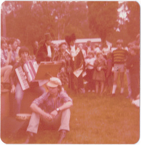 Kew Historical Society Inc
Photograph - Historic re-enactment during the Festival of Kew, 1978
At the 1978 Festival of Kew, a number of organisations, including the City of Kew, the Kew Historical Society, Trinity Boys Grammar School and local Girl Guides participated in a re-enactment of the expedition of the party of Charles Grimes in surveying the Yarra River as far as Kew in February 1803. The location for the event was Yarra Bend Park near the Studley Park Boat House. The event was organised by the Kew Historical Society. The re-enactment was captured by a number of amateur photographers as well as by a photographer from the local Progress Press.Local communities select events to commemorate according to their shared history and values. Commemorations of colonial exploration were popular with local historical groups such as the Kew Historical Society in the twentieth century. In re-enacting events such as the Grimes survey of the Yarra, students from a local school were encouraged to take on specific roles, including play-acting individuals involved in the survey party as well as members of the local Wurundjeri People. The photographs, taken by amateur and professional photographers, represent a period in time when the dominant values were those shared by the descendants of European settlers in Victoria. Original colour photographic positive of the Trinity Grammar School bush band with Mrs Hutchinson and Whiting in the background. The band played at the re-enactment in period costume. Annotated on reverse: "BAND LEADER / 1978 FESTIVAL"kew historical society, trinity grammar school, kew girl guides, city of kew, yarra river, charles grimes, collins expedition, wurundjeri people, yarra bend park, colonial surveys, historic re-enactments, festival of kew, kew festival, cr allan hutchinson, cr noel whiting -
 Kew Historical Society Inc
Photograph - Historic re-enactment during the Festival of Kew, 1978
At the 1978 Festival of Kew, a number of organisations, including the City of Kew, the Kew Historical Society, Trinity Boys Grammar School and local Girl Guides participated in a re-enactment of the expedition of the party of Charles Grimes in surveying the Yarra River as far as Kew in February 1803. The location for the event was Yarra Bend Park near the Studley Park Boat House. The event was organised by the Kew Historical Society. The re-enactment was captured by a number of amateur photographers as well as by a photographer from the local Progress Press.Local communities select events to commemorate according to their shared history and values. Commemorations of colonial exploration were popular with local historical groups such as the Kew Historical Society in the twentieth century. In re-enacting events such as the Grimes survey of the Yarra, students from a local school were encouraged to take on specific roles, including play-acting individuals involved in the survey party as well as members of the local Wurundjeri People. The photographs, taken by amateur and professional photographers, represent a period in time when the dominant values were those shared by the descendants of European settlers in Victoria. Original colour photographic positive of the Mayor of Kew, Cr Noel Whiting, and Cr Allan Hutchinson in period costume as a 'town crier'. Two 'brownies', part of a larger group, stand with their backs to the camera in the foreground. Annotated on reverse: :BROWNIES AT FESTIVAL / [UPPER RIGHT] M.ROLLEY, J. STEWART"kew historical society, trinity grammar school, kew girl guides, city of kew, yarra river, charles grimes, collins expedition, wurundjeri people, yarra bend park, colonial surveys, historic re-enactments, festival of kew, kew festival, mavis rolley, joy stewart -
 Kew Historical Society Inc
Photograph - Historic re-enactment during the Festival of Kew, 1978
At the 1978 Festival of Kew, a number of organisations, including the City of Kew, the Kew Historical Society, Trinity Boys Grammar School and local Girl Guides participated in a re-enactment of the expedition of the party of Charles Grimes in surveying the Yarra River as far as Kew in February 1803. The location for the event was Yarra Bend Park near the Studley Park Boat House. The event was organised by the Kew Historical Society. The re-enactment was captured by a number of amateur photographers as well as by a photographer from the local Progress Press.Local communities select events to commemorate according to their shared history and values. Commemorations of colonial exploration were popular with local historical groups such as the Kew Historical Society in the twentieth century. In re-enacting events such as the Grimes survey of the Yarra, students from a local school were encouraged to take on specific roles, including play-acting individuals involved in the survey party as well as members of the local Wurundjeri People. The photographs, taken by amateur and professional photographers, represent a period in time when the dominant values were those shared by the descendants of European settlers in Victoria. Original colour photographic positive of six students from Trinity Grammar School, dressed in period costume, enacting in 1978 the arrival of the surveyor Charles Grimes at Studley Park in 1803. Annotated on reverse: "BOAT CREW / TRINITY BOYS AS GRIMES PARTY / 1978"kew historical society, trinity grammar school, kew girl guides, city of kew, yarra river, charles grimes, collins expedition, wurundjeri people, yarra bend park, colonial surveys, historic re-enactments, festival of kew, kew festival -
 Greensborough Historical Society
Map, Melbourne and Metropolitan Board of Works. Survey Division, MMBW, Yarra 2500 / 14.21. St Helena, Weidlich Road, 1979_08
Melbourne and Metropolitan Board of Works. Yarra 2500 [base map] 14.21. St Helena, Weidlich Road. Parish of Nillumbik 3310. Municipality of Diamond Valley 257. Prominent streets St Helena Road, Weidlich Road, Karingal Drive and Progress Road. Features include the Blair Reserve.MMBW Map in 1:2500 [scale] series. Cream parchment with green tape reinforcing on edges and punched holes on left edge.mmbw, melbourne and metropolitan board of works, shire of diamond valley, st helena - maps -
 Greensborough Historical Society
Map, Melbourne and Metropolitan Board of Works. Survey Division, MMBW, Yarra 2500 / 16.23. Diamond Creek, 1978_02
Melbourne and Metropolitan Board of Works. Yarra 2500 [base map] 16-23. Diamond Creek. Parish of Nillumbik 3310. Municipalities of Diamond Valley 257 and Eltham 238. Prominent streets include: Phipps Crescent, Bishop Avenue, and Reynolds Road. Includes the former Diamond Creek Technical School.MMBW Map in 1:2500 [scale] series. Cream parchment with green tape reinforcing on edges and punched holes on left edge.mmbw, melbourne and metropolitan board of works, shire of diamond valley, diamond creek - maps -
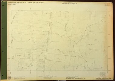 Greensborough Historical Society
Map, Melbourne and Metropolitan Board of Works. Survey Division, MMBW, Yarra 2500 / 14.24. Plenty, 1979_05
Melbourne and Metropolitan Board of Works. Yarra 2500 [base map] 14.24. Plenty. Parishes of Nillumbik 3310 and Morang 3183. Municipality of Diamond Valley 257. Prominent streets include: Heard Road, Hillmartin Road and Yan Yean Road. Features include Plenty Primary School and Plenty Park.MMBW Map in 1:2500 [scale] series. Cream parchment with green tape reinforcing on edges and punched holes on left edge.mmbw, melbourne and metropolitan board of works, shire of diamond valley, plenty - maps