Showing 123797 items matching "main-road"
-
 Melbourne Tram Museum
Pamphlet - Tram works on Swan St, Yarra Trams, Tram Service Changes, 2022
.1 - pamphlet provided at tram stops giving details of the works for 70 .2 - ditto - for Tram Network Upgrade - Swan St and Wallen Road Bridge, Richmond .3 - as for .1 - track reconstruction in Swan St between Stanley St and Stawell St Richmond or BurnleyShows the methods that Yarra Trams customers are advised of changes due to track replacement works. .1>.2 - Pamphlet - DL, four fold DL - Tram Service changes - 11/2022 to 18/2/2022 - Route 70 .3>.4 - Pamphlet - DL, four fold DL - Tram Network Upgrade - Swan St and Wallen Road Bridge, Richmond .5 - Newspaper clipping - Tram works on Swan Sttram works, track work, yarra trams, ptv, bridges, trams, tramways, richmond, burnley, route 70, wallen road bridge -
 Mt Dandenong & District Historical Society Inc.
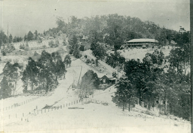
Photograph, The Gap Under Snow 1921, 1921
Snow scene looking up through The Gap (FiveWays) with Mountjoy Guest House on the hill to the right. The shop and post office are seen in the centre of the picture. This photograph has a detailed inscription on the back handwritten by John Lundy-Clarke in 1974.The Gap under snow 1921. “Mountjoy” on hill. New CRB road formation (unmetalled) comes into picture lower left corner, passes left of dray under the elms, then circles around behind the trees behind Miss Hands shop and home and Post Office (Mt Dandenong North) to pass out of picture left in centre of picture. It passes between Ted Prices Hay & Corn store and Walker’s house where the Estate Agency was later placed. Main Road then in centre of picture bend right behind Mountjoy. Price’s house and shop behind the blackwood left of road bend. CRB cuts across Barbers left of Elm trees.john lundy-clarke, kalorama, mountjoy, mountjoy, the gap, post office, mt dandenong north, snow -
 Melbourne Legacy
Photograph, Legatee William Donovan Joynt, V.C. book launch, 1979
Photograph taken to record the launching of Donovan Joynt VC's autobiography, Breaking the Road for the Rest (see Cat. No. 01353). The Legacy torch on the wall behind indicates that the launch took place at Legacy House in Swanston Street, and is confirmed in the text of the newspaper cutting. The cutting also records the fact that Joynt was then the oldest surviving member of Melbourne Legacy. A further newspaper cutting by Geoffrey Hutton reviews the book in detail.A record that the Governor of Victoria launched the book is an indication of the high profile of both Joynt and Melbourne Legacy.Black and white photo of L/- Donovan Joynt and Governor WinnekeOn back of photo: 'MELBOURNE LEGACY' stamped in purple. '19.3.79' written in blue biro 'The Governor Henry Winneke launching Donovan Joynt's book Breaking the Road for the Rest' in green biro On newspaper cutting: 'L11' in blue biro donovan joynt, biography -
 Eltham District Historical Society Inc
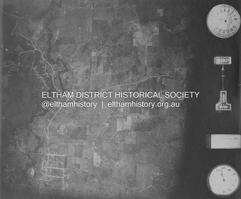
Photograph - Aerial Photograph, Landata, Eltham and Eltham East, Nov. 1931
Centred over present-day Beard Street bewteen Park Road and Main Road, Eltham East Historic Aerial Imagery Source: Landata.vic.gov.au Aerial Photo Details: Project No :1931 Project : MALDON PRISON Run : 20 Frame : 3135 Date : 11/1931 Film Type : B/W Camera : F8 Flying Height : 11000 Scale : 18860 Film Number : 60 GDA2020 : 37°42'16"S, 145°09'41"E MGA2020 : 337912, 5825386 (55) Melways : 22 B2 (ed. 42)aerial photo, eltham, neil webster collection, beard street, eltham east, main road, park road -
 Eltham District Historical Society Inc
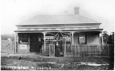
Photograph, General Store, Research, c.1900-c.1910
The original General Store at Research was also known as Doneys. It was located near where the present Main Road Research Shops are situated (opposite Ingrams Road). Charles Doney shown in front of the store. His wife Blanche is at the gate and his mother on the verandah. They had two boys Lance and Bill. The mother gave her daughter the opportunities and the graces. One of the children lived in a railway carriage behind the Church of England Research. A single chimney was unusual for a building like this. Store was demolished c. 1968 Cross Ref: SEPP_0501This photo forms part of a collection of photographs gathered by the Shire of Eltham for their centenary project book,"Pioneers and Painters: 100 years of the Shire of Eltham" by Alan Marshall (1971). The collection of over 500 images is held in partnership between Eltham District Historical Society and Yarra Plenty Regional Library (Eltham Library) and is now formally known as the 'The Shire of Eltham Pioneers Photograph Collection.' It is significant in being the first community sourced collection representing the places and people of the Shire's first one hundred years.Digital image, 18.5 x 29.5 cm print, 15.5 x 25.5 cm print and 120 format B&W negativesepp, shire of eltham pioneers photograph collection, research (vic.), general store, post office, doney family -
 Mission to Seafarers Victoria
Photograph - Photograph, Colour, 1991?
The centre is at the main dock gate (Corry Road) within easy walking distance of most ships on North Shore. Facilities include a Flying Angel Centre with free Wifi & computer access, a bar and café, currency exchange, a choice of mobile phone & internet cards, pool table, chapel, gift shop, clothes shop and lounge area. Belfast is one of the many centres from the Mission to Seafarers network around the world.Mission located in the docks in Belfast North Ireland. Behind is the St Joseph's Church Sailortown.mission to seafarers, seamen's mission, mission to seamen, belfast, north ireland, ports -
 Greensborough Historical Society
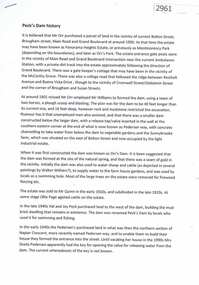
Document, Judith Dodd?, Peck's Dam history, 1900o
History of a parcel of land bounded by Bolton Street, Brougham Street, Main Road and Grand Boulevard purchased by Mr Orr around 1900. It may have been called Panorama Heights Estate, Montmorency Park and later, Orr's Park. Orr had a dam made, which was called Peck's dam by locals in the 1940s-1950s.2p. typescriptorrs park, montmorency, pecks dam -
 Eltham District Historical Society Inc
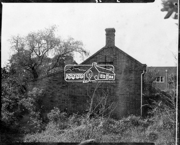
Photograph, Side view of Shillinglaw Cottage
Side view of 'Shillllinglaw Cottage' in its original location on Main Road Eltham, 1964. The cottage was built by George Stebbings about 1859 and is made from hand made bricks laid in a Flemish bond pattern. In the 1960s it was marked for demolition to make way for the construction of new council buildings but a community campaign saved the cottage and it was re-located.Shillinglaw Cottage is itself historically, aesthetically and socially significant to the Shire of Nillumbik and is registered on the Victorian Heritage Database. This photo forms part of a collection of photographs gathered by the Shire of Eltham for their centenary project book, "Pioneers and Painters: 100 years of the Shire of Eltham" by Alan Marshall (1971). The collection of over 500 images is held in partnership between Eltham District Historical Society and Yarra Plenty Regional Library (Eltham Library) and is now formally known as 'The Shire of Eltham Pioneers Photograph Collection.' It is significant in being the first community sourced collection representing the places and people of the Shire's first one hundred years.Digital imagesepp, shire of eltham pioneers photograph collection, eltham, shillinglaw cottage -
 Eltham District Historical Society Inc
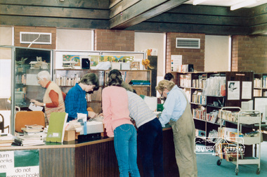
Photograph, Eltham Library, 1985, 1985
Eltham Library opened in 1971 after a wing was added to the south side of the Shire of Eltham offices in Main Road Eltham. This library closed in 1994 when the new library in Panther Place was opened. Shire of Eltham Archives Series 13, Photograph Album, 1985. Originally contained in a 2-ring PVC binder and document sleevesFive colour photographsseries 13, shire of eltham archives, eltham library -
 Warrnambool and District Historical Society Inc.
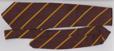
Textile - Warrnambool Primary School 1743 Tie, Circa 1950’s
Warrnambool State School, No, 1743 was opened in 1876. The site in Jamieson St was easy to access from the surrounding areas of Belfast, Woodford, and Allansford roads. It was the main school in Warrnambool, before the development of Primary schools at East and West Warrnambool. A large part of Warrnambool’s children have attended this school over the 140 years it has been in existence.A common item with which a large number of Warrnambool residents would identify. Brown woven woollen tie with diagonal yellow stripes. White tag with black and red writing sewn into back seam.Tee- Dee, pure wool, school and college wear. warrnambool, warrnambool jamieson street primary school, no 1743, school tie, warrnambool primary school -
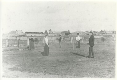 Lake Bolac & District Historical Society
Black and white photograph, Lake Bolac, original tennis court, 1895
The original tennis court at Lake Bolac in 1895 was located at the Recreation Reserve behind the linear development along the main road. This was a grass court, lines were clearly painted and the tennis-net was a chicken-wire fence. In the photograph are from left; Eva Veale, Alice Veale, Thomas Ward, Annie Veale and William Veale jr.lake bolac, tennis, veale, ward -
 Eltham District Historical Society Inc
Photograph, Charles Withers (aka Bill) and his friend Mervyn Britain (right) in their trench at Southernwood, Eltham, 1916
Charles Withers (aka Bill) with his good friend from school, Mervyn Britain with mock trenches and rifles at the Withers family home, Southernwood, Eltham. The view is looking to the east with Main Road and associated buildings near ridge in distance. [Charles son, John Withers explained that his father and friend liked to play war games.]On back of photo: "Bill (left) Mervyn (right) in their trench 1916" Many items in this collection have suffered from significant water damage and black mouldjohn withers collection, eltham, 1916, main road, southernwood, trenches -
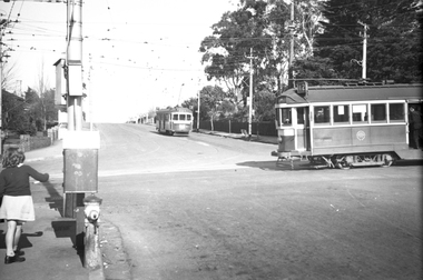
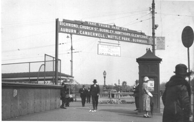 Melbourne Tram Museum
Photograph - Princes Bridge - Batman Ave tram signage, 1920s
Photo shows the signage at the Batman Ave tram terminus showing which suburbs or locations, trams ran to, for both Batman Ave and St Kilda Road. Under the main sign is a sign stating "Melbourne V Collingwood Semi-finals today". Based on https://www.afltables.com/afl/seas/1926.html - could be either 1926 or 1928.Yields information about the MMTB signage at the Batman Ave tram stop c1920.Black and white photograph with a plain back.tramways, batman ave, princes bridge, football -
 City of Kingston
Photograph - Black and white, 3 March 1954
Cheltenham and Moorabbin are suburbs within the City of Kingston that were originally established as rural market gardening communities The area is bordered by Highett and Mentone. The market gardens, farms and paddocks have gradually been sub-divided into housing and industrial estates. Highett is developed with residential homes but was also the site of major facilities such as the Highett Gas Works. This aerial image covers a diverse section of the City of Kingston, taking in the suburbs of Moorabbin, Cheltenham, Highett and Mentone Residential housing development is prominent along the Frankston Railway line and the area still retains extensive market gardens and paddocks yet to be converted to a large industrial and commercial zone.Aerial photograph of Mentone, Cheltenham and Moorabbin within the City of Kingston. The area depicted in this 1954 aerial view includes Warrigal Road and Centre Dandenong Road intersection (top left); Charman Road, Patty Street, Bourke Street, Collins Street Mentone (top right); Keys Road Moorabbin (bottom left); Bay Road, Cheltenham (bottom right), Friendship Square, Cheltenham Park, Victoria Golf Club and Jack Barker Oval are visible. Nepean Highway and the Frankston railway line run centrally through the image. Highett Gasworks is also evident.White handwriting and type [indecipherable]. White image of clockface White image of compass White type 42956 Black handwriting 3/3/54 Williams [indecipherable] Black pencil: S [arrow] Black ink: 3/3/1954cheltenham, moorabbin, mentone, highett, market gardens -
 Bendigo Historical Society Inc.
Map - LONG GULLY HISTORY GROUP COLLECTION: MAP OF LONG GULLY/CALIFORNIA GULLY AREA
BHS CollectionTwo copies of a map, printed on yellow paper, of the Long Gully/California Gully Area. It shows Eaglehawk Road from Craig Street then Mr Korong Road,to the Murray Valley Highway to just past Avenue Street. Sandhurst Road and Holmes Road are to the right. To the left is California Gully Road. Water Supply Purposes Reserve, Mental Hygiene Authority, Comet Hill State School Reserve, Agricultural Showgrounds and Recreation Reserve, Rubbish Reserve and two un-named State Schools are shown. Some contours are also shown.bendigo, history, long gully history group, the long gully history group - map of long gully/california gully area -
 National Wool Museum
Work on paper - Women's Village/Travel Uniform Design Drawings, Wendy Powitt, c. 1992
A set of laminated A3 sketchbook pages depicting designs for the 1992 Barcelona Olympic Women's Village/Travel Uniform designed by Wendy Powitt. On the 1992 Barcelona Olympic Games donor Doug Pleasance wrote- The 1992 Barcelona Olympic Games saw an evolutionary change in designer selection. A Declaration of Interest Form was communicated to over forty potential designers. The task and especially tight timelines that were involved deterred many aspirants, however, there remained eight designers with the potential we were seeking. These eight designers were paid $3,000 per submission and the winning designer, Wendy Powitt, was paid $15,000. For the first time the judging panel included two athletes, one male swimmer and one female basketballer, their influence was pivotal. The village clothing was designed to be a highly visible garment meaning that it was easy to "Spot the Aussies" and helped to contribute to a good team spirit. Blocks of contrasting colours were a feature of the pure wool shirts. A newly developed stretch 50:50 wool/cotton fabric by Bradmill was made into shorts and jeans by Fletcher Jones.8118.1- A laminated A3 sketchbook page depicting a design for the 1992 Barcelona Olympic women's Village/Travel Wear Uniform. The main drawing shows the design for a pair of yellow shorts with a yellow and green printed, striped shirt, cinched at the waist by a brown woven belt. At the bottom of the page is a detailed drawing of the weave of the belt with an Australia shaped belt buckle. A small drawing to the right of the main image also details a small bag/pouch that attaches to the belt. 8118.2- A laminated A3 sketchbook page depicting a design for the 1992 Barcelona Olympic women's Village/Travel Wear Uniform. The main drawing shows the design for a pair of yellow shorts paired with a block colour shirt in green, red, white and yellow with a symbol in the shape of Australia on the right side of the shirt. There are small detail images of shorts and a skirt to the left of the main image and a detail drawing of a brown leather shoe to the right.1992 barcelona olympics, sport, athletes, fashion, design, artwork, drawing, uniform -
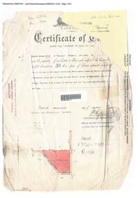 Ringwood and District Historical Society
Document, Certificate of Title - Edward Thomas Miles, Gentleman, "Woorara", Ringwood - part of Crown Section 20, Parish of Warrandyte, County of Evelyn - 1913
A4 copies of damaged Landata Victoria Historical Search documents - Vol 3726 Fol 200 - incomplete proprietor and transfer details.Edward Thomas Miles is now the proprietor of an Estate in Fee-simple subject to the Encumbrances notified hereunder ... 27 acres 19 perches or thereabouts, together with a right of carriage way over roads coloured brown. Subdivision map includes un-named roads - western side is Wonga Road (later Warranwood Road), and eastern side is Grandview Grove (later Bemboka Road), both north of Plymouth Road, Ringwood, Vic. Transfers include (illegible) Dobbs, November, 1927 - 5 acres Harry Temple Marshall, 1st December, 1928 - 10ac 3r David Edward Meyland, 4th October, 194-? (illegible). -
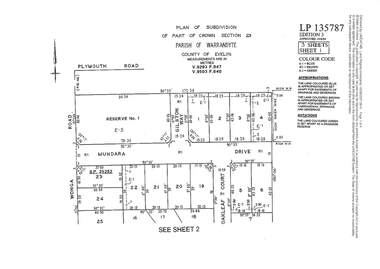 Ringwood and District Historical Society
Document - Subdivision Plan, LP135787 Part of Crown Section 23, Parish of Warrandyte, County of Evelyn, Vol 9293 Fol 947 and Vol 9503 Fol 640 - 1984
LANDATA Land Victoria 3-sheet plan printout dated 2007Sheet 1 includes Wonga Road, Mundara Drive, Gilston Way and Oakleaf Court, Ringwood. Additional markings include SP25252. Sheet 2 includes Wonga Road and Oakleaf Court, Ringwood. Sheet 3 includes Wonga Road, Wyndarra Court and Gem Close, Ringwood. -
 Southern Sherbrooke Historical Society Inc.
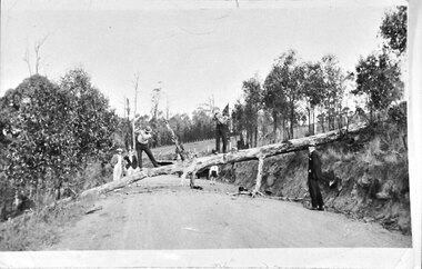
Photograph - Chopping up a fallen tree just before Herman's Corner
Photo shows a tree lying across a road, having fallen from a high bank on the right. Two men are standing on the tree and appear to be cutting it with axes. Three other men are watching. A child stands further down the road, partially obscured by the tree. This is near Hermons Corner on the (now) Belgrave-Gembrook Road, Menzies Creek. The land on either side of the road is part of the Breen farm and the two axemen are the Breen brothers. -
 Ballarat Tramway Museum
Photograph - Colour Photograph/s set of 2, Warren Doubleday, 13/03/1998 12:00:00 AM
Set of two colour photographs of the depot floor at the rear of No. 2 and 3 road after hotmixing and No. 2 road, between the rails on Friday March 13. Photographs by Warren Doubleday. On Kodak Paper. 848.1 - shows area at the rear of No. 2 and 3 road, with change room in the background. 848.2 - shows area between 1 and 3 roads, with 39, 26 and 38 in background. See March 1998 Fares Please!depot, floor surface -
 Melbourne Tram Museum
Negative, Wal Jack, 24/07/1944 12:00:00 AM
Black and white negative, by Wal Jack, of W2 638 (Route 42) in Whitehorse Road crossing Burke Road, Camberwell, with SW6 883 (City Route 7) at the terminus. Note the curves in front of the tram which allowed for cars to turn from Whitehorse Road Westbound into Burke Road. Note the conductor standing in the doorway. Photo dated 24-7-1944 in the Wal Jack album along with details of the location and the tramcar.trams, tramways, balwyn, whitehorse road, burke road, w2 class, sw6 class, tram 638, tram 883 -
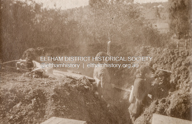
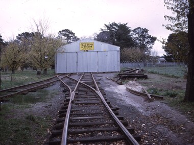
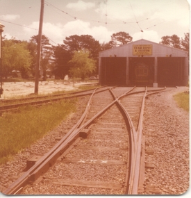 Ballarat Tramway Museum
Photograph - Colour Photograph/s - set of 2, Stephen Butler, c9/1978
Yields information about the construction of the BTPS Depot extensions c Sept. 1978.Set of 2 colour prints of tram the depot extensions being constructed c September 1978. .1 - view from 2 /3 road points with a tram on the 3 road extension. .2 - photo of 4 road pit with water in it. See Annual Report and September 1978 Fares Please!trams, tramways, btps, depot extensions -
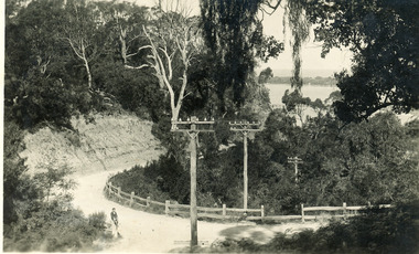 Lakes Entrance Historical Society
Postcard, Bulmer H D, 1940c
Black and white postcard of a bend in the Prince's Highway as it winds around Jemmys Point. Steep road cutting on upper side of gravel road, post and rail fence on lower side, schoolboy sitting on fence in foreground, dense vegetation on top of cutting and gully beneath road. Lakes Entrance VictoriaA bend in the Princes Highway, Lakes Entrancefences, transport, roads and streets, islands -
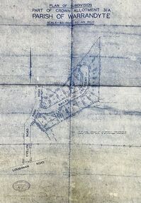 Ringwood and District Historical Society
Map - Plan of Subdivision, Part of Crown Allotment 31A, Parish of Warrandyte - (Undated)
Facsimile blueprint copy of 24 residential allotments with property dimensions in Bailey Crescent (later Gabriella Court) and McEwan Street (later Suzanne Court) off Park Road and Evelyn Road, Ringwood North. Attached photocopy of undated map of allotment on south-east corner of Evelyn and Park Roads.Rubber stamp impression - J. Horne, Licensed Surveyor, 458 Nepean Highway, Frankston 31736. -
 Bacchus Marsh & District Historical Society
Photograph, Timmons. Clothier and Draper. Victoria House. 1883
This building was part of a range of shops known as Victoria House, built by Vere Quaile, blacksmith, in 1857. It consisted of a shop, a blacksmith's forge and wheelwright, and was located to the east of the blacksmith's forge in Main Street. Between 1874 and 1892 Francis Timmons operated a clothier and drapers business in this building.Small sepia unframed photograph on card with gold border framing photograph. The name of the business can be clearly seen above the awning. Less clear is the name "Victoria House', also above the awning. Housed in the album, 'Photographs of Bacchus Marsh and District in 1883 by Stevenson and McNicoll'.On the front: Stevenson & McNicoll. Photo. 108 Elizabeth St. Melbourne. COPIES CAN BE OBTAINED AT ANY TIME. On the back: LIGHT & TRUTH inscribed on a banner surmounted by a representation of the rising sun. Copies of this Portrait can be had at any time by sending the Name and Post Office Money Order or Stamps for the amount of order to STEVENSON & McNICOLL LATE BENSON & STEVENSON, Photographers. 108 Elizabeth Street, MELBOURNE. In handwriting: 'Victoria House'. Clothier + Draper. Main St. c.1857. Next to Blacksmith Cottage. Courtesy Mrs. Jeremeas. Photo 1883.stevenson and mcnicoll 1883 photographs of bacchus marsh and district, shops bacchus marsh vic., clothing shops, drapers bacchus marsh vic -
 Hume City Civic Collection
Photograph, 1/08/1980
On 4th August 1978 the construction of the Goonawarra Estate commenced. The estate was formerly known as the Goonawarra Farm and overlooked the Sunbury town and the Jacksons Creek valley. Plans for the development included a golf course, houses, community and recreational facilities..The golf course opened in 1980 and the housing construction continued throughout the last two decadesd of the twentieth century and into the twenty firsat century.A coloured photograph showing the signpost indicating the entrance to the Goonawarra Estate from Sunbury Road. Trees are growing on either side of the road and Mt. Holden can be seen across the skyline.goona warra golf club, goonawarra farm, goonawarra housing estate, sharkey, robert b., kilkenny homes, australian ideas homes pty.ltd., craftsmen homes., glamor homes, villa bella homes, mt. holden, george evans collection -
Whitehorse Historical Society Inc.
Legal record - Document, Certificate of Title, 1977
Certificate of Title vol. 5564 fol. 1112691 for part of Lot 13 Plan of Subdivision no. 4488, cnr. Creek Road and East Road Mitcham, owned by George Albert SmithCertificate of Title vol. 5564 fol. 1112691 for part of Lot 13 Plan of Subdivision no. 4488, cnr. Creek Road and East Road Mitcham, owned by George Albert SmithCertificate of Title vol. 5564 fol. 1112691 for part of Lot 13 Plan of Subdivision no. 4488, cnr. Creek Road and East Road Mitcham, owned by George Albert Smithcreek road mitcham, smith, george albert, east road mitcham -
 Whitehorse Historical Society Inc.
Photograph, Vermont Intersection C.1967, C.1967
Part of Tim Shambrook's Collection for 'This is Vermont'. Not used.Coloured photo of Shell Service Station (since replaced with Convenience Store) on corner of Boronia & Canterbury Roads, Vermont. Taken outside St. Lukes Anglican Church on Mitcham Road.shell service station, vermont, boronia road, canterbury road, mitcham road, st. lukes anglican church, shambrook, tim -
 Ballarat Tramway Museum
Slide - 27 mm sq slide/s, Andrew Howlett, BTPS depot under construction, Jun. 1973
Yields information about the BTPS Tram depot construction and track work.Colour slides, Kodak white cardboard mount, developed June 1973 of the BTPS depot with the track to Nos. 2 and 3 road constructed and the hole for the overhead in No. 2 road made."Sebastopol term" in red ink.ballarat, tramways, trams, btps, depot, trackwork -
 Kew Historical Society Inc
Photograph, Deepdene
Rare photograph of a significant Melbourne home.Photograph of the historically significant house, Deepdene, which was located before demolition on the southeast corner of Burke Road and Cotham Road. The photograph is on the back of a subdivision plan of the Auburn Heights Estate.deepdene