Showing 123551 items matching "main-road"
-
 Bendigo Historical Society Inc.
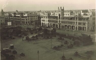
Postcard - ACC LOCK COLLECTION: B&W PHOTO OF BUILDINGS FACING A TOWN SQUARE, POSTCARD, 1914-1918
Postcard, WW1, B&W photo of a row of buildings facing a town square. Two copies of the same photo. On the back of one postcard - handwritten in ink 'View of Heliopolis from Palace Hospital Feb'16. Town identified as Heliopolis, a suburb of Cairo, Egypt. Main building with tower probably contains shops. Vehicles parked at lower left includes an ambulance. A tram along the main steet is partially hidden by trees.postcard, postcard, ww1, heliopolis, egypt -
 Creswick Museum
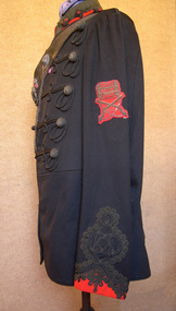
Officer's Uniform Creswick Volunteer, Circa 1880
Uniform used by Major Philip Ketch, Commanding Officer Creswick Volunteers (1883). Was on display for many years at Ballarat Ranger Barracks but at the families request returned to Creswick MuseumOnly known uniform on display of the Creswick (Ballarat) Volunteers.Creswick Volunteers Officer's Dress Tunic. Main body in black wool fabric with rounded red stand up collar and braid. Sleeves end with red wool pointed cuffs with braid. Braiding on main body of uniform. Froged with 5 rows of braid ending with netted button. On sleeve badge with crossed rifles year 1883 and above years 1880, 1881, & 1882. Leather belt across shoulder with whistle attached.volunteer uniform, creswick, philip ketch -
 Kiewa Valley Historical Society
7 small black and white photographs of Pretty Valley, c1948
In 1947 it was proposed to construct a dam on the Pretty Valley branch of the East Kiewa River. This was part of the initial planning in 1937. The Pretty Valley Reservoir was to be part of a pumped-storage scheme with a pumping station located immediately below the main structure. Preparatory work was commenced in 1946 with erection of staff accommodation. Between 1947 and 1950 the main camp was erected, access roads, constructed and banks and benches at the dam site undertaken. Following the financial crisis in 1951, a review of the scheme was carried out and work ceased in June 1951. Construction of the dam was deleted from the programme of works and all buildings removed.A pictorial history of part of the initial planning in 1937 for a dam to be constructed at Pretty Valley as part of the Kiewa Hydro Electric Scheme.7 small black and white photographs of Pretty ValleyAll photos have a circular stamp on the back with 'Print by Willson White Albury' enclosed. Photo 1 - on the back, handwritten in ink 'New 22Kv pump line - Pretty Valley Nov. 1948'. In pencil '18'. Photo 2 - On the back, handwritten in ink 'Pretty Valley - Staff mess on right Nov. 1948'. In pencil '18'. Photo 3 - On the back, handwritten in ink 'Pretty Valley Basin - looking S.E. Nov. 1948'. In pencil '5'. Photo 4 - On the back, handwritten in ink 'New pump 22Kv line, Pretty Valley - looking towards Mt. Mackie. Nov. 1948'. In pencil '5'. Photo 5 - On the back, handwritten in ink 'Pretty Valley. Mt. Cope just out of picture extreme right. Nov. 1948'. In pencil '78'. Photo 6 - on the back, handwritten in ink 'View from Pretty Valley Ruined Castle in Background Nov. 1948'. In pencil '78'. Photo 7 - on the back, handwritten in ink 'Pretty Valley Pump line (Nov. 1948)'. In pencil'78'.construct, dam, pretty valley -
 Ringwood and District Historical Society
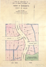
Document - Real Estate Folder, Savernake Estate, Ringwood, Victoria - Stage one - 1967
Plan of Subdivision, Part of Crown Allotment 31A and advertisement for sale of residential allotments with map showing layout of subdivision. Typewritten pricelist attached outlining suggested terms of sale as of 14 September, 1967.Subdivision includes Evelyn Road, Cameron Road, Klead Court, and San Remo Road. Agent - C.E. Carter & Son., 126 Whitehorse Road, Ringwood. (Phone) 87-6024, 87-6830, 870-2519, After hours: 723 3298, 878 2648. Subdivision Plan stamped Donald Cameron Consultants Pty. Ltd., Consulting Engineers, 472 Bourke Street Melbourne - 67-2602. -
 Ringwood and District Historical Society
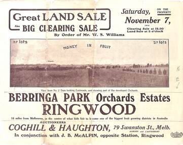
Pamphlet - Auction Sale, Berringa Park Orchards Estate, Ringwood, Victoria - 1914
Multi-fold brochure advertising public auction of 37 lots on Saturday 7th November, 1914. Brochure includes terms of sale, description of subdivision features and local facilities, and photographic images of the area. Three-page Park Orchards Estate Price List attached.Subdivison includes Smedley Road, Oban Road, Berringa Road, and Williams Road, North Ringwood. Auctioneers: Coghill & Haughton, 79 Swanston Street, Melbourne, in conjunction with J.G. McAlpin, Ringwood. Brochure includes Clearing Sale to be held same day for "everything required to work these orchards, from a packing needle to a traction engine ... comprising the most up-to-date and extensive farm & chaffcutting plant in this great district". -
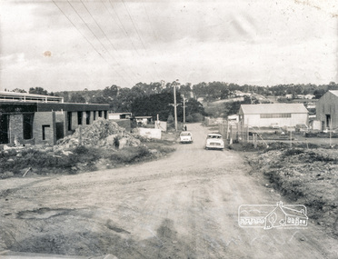
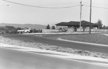 Ringwood and District Historical Society
Photograph, View Southwest across the Wonga-Oban Roads roundabout. 1981
Written on back of photograph, "1/7/81. View Southwest across the Wonga-Oban Roads roundabout. Oban Road in foreground. Wonga Rd goes right up centre" -
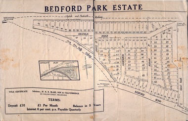 Ringwood and District Historical Society
Plan - Sub-division, Bedford Park Estate, Ringwood, Victoria - 1924
Bedford Park subdivisional development did not eventuate. The land adjoining the railway line became parkland with provision for sporting facilities and the remainder was purchased by the Education Department as the site for Ringwood High School/Secondary College. Poster size land sale advertisement.Subdivision plan includes Bedford Road, Graham Road, Joyce Street, Anderson Street, and Adams Street. Solicitors - W.R.R. Blair, Son & Falconbridge, 405 Collins Street, Melbourne. -
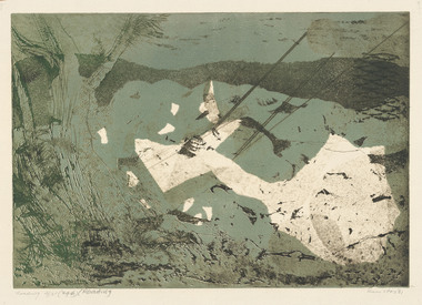 Latrobe Regional Gallery
Print, HOS, Kees. Born 1916, The Hague, Holland, Roading (296), 1961
PrintTitled and edition 'Roading 4/25 (296) (Roading' lower left under printed image. Signed 'Kees Hos '61' lower right corner under printed image. -
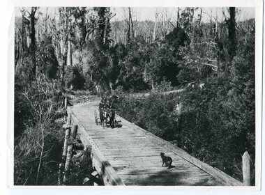 Orbost & District Historical Society
black and white photograph, 1913
This photograph is of the low level bridge across the Bemm River about 50 km east of Orbost in East Gippsland.This is a pictorial record of the 1913 low level bridge across the Bemm River, East Gippsland.A large black / white photograph of a horse - drawn wagon on the low level Bemm River bridge. In the foreground on the bridge is a dog.on back - "Country Roads Board Princes Highway low level bridge" -
 Eltham District Historical Society Inc
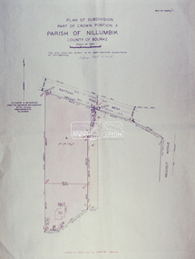
Slide - Photograph, Eltham Shire Council, Plan of Subdivision, Part of Crown Portion 3, Parish of Nillumbik, County of Bourke, 1969
35mm colour positive transparency blue Agfacolour Service plastic mountC5C, Delbridge, 4 lots, Rattray Road, 4 August 1969infrastructure, map, montmorency, planning, rattray road, subdivison lots, reichelt avenue -
 Eltham District Historical Society Inc
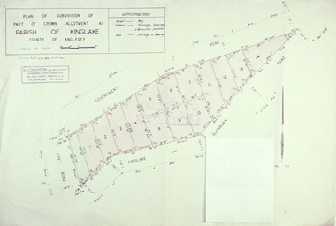
Slide - Photograph, Eltham Shire Council, Plan of subdivision of Part of Crown Allotment 41, Parish of Kinglake, County of Anglesey, 1969
35mm colour positive transparency blue Agfacolour Service plastic mountC8, N. Johnson, Kinglake-Glenburn Road, 4 August 1969infrastructure, map, planning, subdivison lots, n. johnson, kinglake-glenburn road, kinglake -
 Eltham District Historical Society Inc
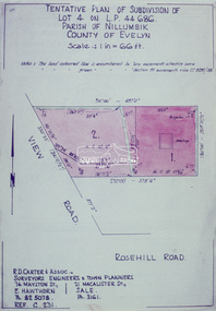
Slide - Photograph, Eltham Shire Council, Tentative Plan of Subdivision of Part of Lot 4 on L.P. 44 686, Parish of Nillumbik, County of Evelyn, 1969
35mm colour positive transparency blue Agfacolour Service plastic mountB3 Robinson prelim subdivision, View Road, 4 August 1969infrastructure, map, planning, subdivison lots, view road, rosehill road, lower plenty -
 Eltham District Historical Society Inc
Slide - Photograph, Eltham Shire Council, Plan of Subdivision, Part of Crown Portion 3, Parish of Nillumbik, County of Bourke, 1969
35mm colour positive transparency blue Agfacolour Service plastic mountB3 Robinson prelim subdivision, View Road, 4 August 1969infrastructure, map, planning, subdivison lots, rattray road -
 Bendigo Military Museum
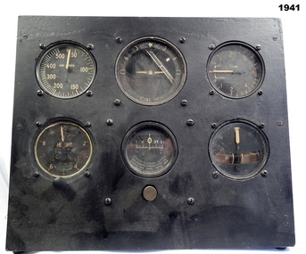
Equipment - INSTRUMENT PANEL RAAF, Early WW2
Belonged to Maxwell Lennox Matheson 418447 RAAF. Refer 1959 for his service history.Wood frame block with six (6) instruments, round shape set in the wood frame. The 6 instruments all different all represent a replica of a standard "sperry flight instrument panel". These parts were fitted to most RAF and RAAF aircraft. "M Matheson 87 Reservoir Road Strathdale Bendigo" (Label on rear).instruments, equipment, raaf -
 Eltham District Historical Society Inc
Photograph, Brisbane Street, Eltham (unmade) from west end, 1969, 1969
Brisbane Street, Eltham (unmade) from west end, showing light industrial area 1969black and white photograph with white borderverso: Brisbane Street before road made 1967 looking east eltham, 1969, roads, streets, brisbane street, light industrial area -
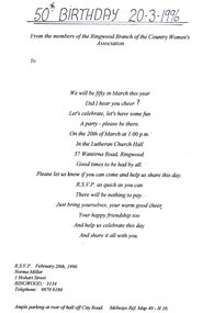 Ringwood and District Historical Society
Flyer, Invitation to 50th birthday of CWA Ringwood Branch in 1996
Kindly scanned from Ringwood Branch archival collectionAt the Lutheran Church Hall, City Road, Ringwood on 20th March 1996 -
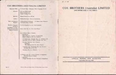 Bendigo Historical Society Inc.
Document - COX BROTHERS ( AUSTRALIA) LIMITED, 31 July 1969
Document, Cox Brothers ( Australia ) Limited, (Incorporated in Victoria), Annual Report and Accounts Year ended 31st July,1969.Subsidiaries: include Foy & Gibson Limited (Victoria); 75 Flinders Lane (Bendigo)Pty, Ltd.( Victoria)----In Liquidation (Formerly Myers (Bendigo) Pty. Ltd.Wilke and Company Limited, 37-49 Browns Road, Clayton, Victoria.document -
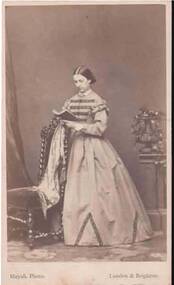 Bendigo Historical Society Inc.
Photograph - PORTRAIT OF A LADY
Small full length portrait of a lady standing beside a chair reading a book which is resting on the back of the chair. She is wearing a long high neck dress with frills at the sleeve tops and dark bands across the bodice. The dark material is also repeated at the hem in a V shape. Photographer's name and address printed on the front and back.Mayall, 224 Regent Street, London. 90 King's Road, Brightonphotograph, portrait, female, portrait of a lady, mayall -
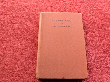 Robin Boyd Foundation
Book, A.G. Macdonell, The Fur Coat, 1944
Hardcover, No Dust Jacket"Patricia Boyd, 11A Clendon Road, SE3" inside front coverwalsh st library -
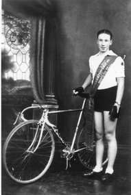 Stawell Historical Society Inc
Photograph, Mr Ron Bates 1935 -- Studio Portrait
Ron Bates in Cycling clothing & championship sash across his chest holding onto his bike seat with his right hand. He has cycling gloves on.Bike has Healing written on it. Australian Junior Road Championship 1935 -
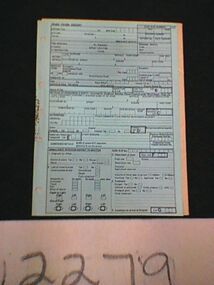 Ambulance Victoria Museum
Form, Booklet, Patient Care record, Road Crash Reports, circa early 1970's
Booklet /pad of pale blue paper forms with black print. Many fields on which to record patient information. The forms are glued along the left hand edge and punched with holes to allow insertion into ring binder.These include the following ; ROAD CRASH REPORT AMBULANCE OFFICERS REPORT TO DOCTOR road crash report, form, patient care form -
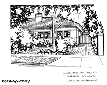 Hawthorn Historical Society
Drawing - Property Illustration, 16 Currajong Street, Hawthorn East
'After training as a Cartographic Draftsman within the mining industry, I worked as a property illustrator for real estate firms in the eastern suburbs of Melbourne for 23 years from 1983. I initially photographed houses with a Polaroid camera and made a 'thumbnail' sketch while there. The photos were used to scale off a sketch in pencil and then that sketch was overlaid with drafting film and the 'pen and ink' completed. The pens I used were the Rotring ‘Rapidigraph’ drafting pens. The ink was also made by Rotring (German).The film was ‘Rapidraw’, polyester drafting film, double matte. It takes a very fine line and doesn’t bleed. As well as house sketches, there were often floor plans and site plans ordered. Aerial sketches were ordered when the property needed an overall view.' (Margaret Picken, 2020)This property illustration is one of a series created by Margaret Picken for a range of real estate agents in Melbourne between c. 1983 and c. 2006. Each work is signed and dated by the artist.Gift of Margaret Picken, 2020Pen and ink property illustration on drafting film of 16 Currajong Street, Hawthorn East by Margaret Picken.16 Currajong Road, Haw, Margaret Picken '94. Woodards - Hawthorn.artist - margaret picken 1950- -
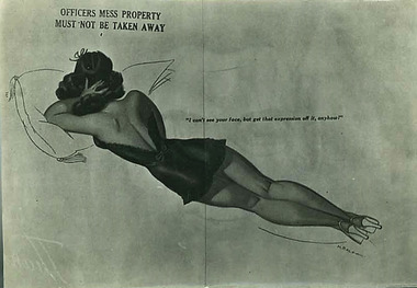 Ringwood RSL Sub-Branch
Photograph - Various Photos of ladies painted on aircraft WW2, c. WW2
Set of photographs documenting ‘pin up’ nose artwork on American bombers in the Pacific theatre. 27 black and white photographs of aircraft nose artwork. .1) ‘Officers Mess’ .2) ‘The Strip Polka’ .3) ‘Lazy Lady’ .4) ‘Norma’ .5) ‘ The Rube’ .6) ‘Bubbles’ .7) ‘Cookie’ .8) ? .9) ‘Windy City Kitty’ .10) ‘Heaven Can Wait’ .11) ‘Baby’ .12) ‘Jose’s El D’ablo’ .13) ‘Pride of the Yanks’ .14) ‘Nobody’s Baby’ .15) ‘Pistol Packin’ Mama .16) “Target for Tonight’ .17) ‘Louisiana Lullaby’ .18) ‘Jack Pot’ .19) ‘The Lonesome Angel’ .20) ‘Whooo’ .21) ‘Sky Witch’ .22) ‘ Flying High’ .23) ‘Yankee Doodle Dandy’ .24) ‘Margie’ .25) ‘Twin Nifty’s’ .26) ‘Blonde Baby Eva’ .27) No name .28) No Name .29) Un redable .30) ‘Gone With the Wind’ .31) ‘The Strip Polka’On Back of .1) Coulsan, 120 Hampden Road, Artarmon, NSW, 2064pin up art -
 Emerald Museum & Nobelius Heritage Park
Postcard - Postcard of Welsh village
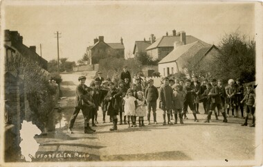
The donor's maternal great-grandfather, Evan Rees, was born in Llangendeirne, Wales in 1862 and emigrated to Australia in 1887. This postcard appears to be circa 1900s from the clothes worn by the children. The donor believes this postcard belonged to her father's mother, Maggie Johnston Rees (1867-1964). These and other postcards and photos came from the estate of David Moyle (1938-2015) who was a police officer in Emerald during late 1960s-early 1970s, and subsequently at Belgrave in the early 1980s. David Moyle was closely associated with the now defunct Sherbrooke Historical Association.This postcard is significant because it was part of a collection belonging to a community member who had a close association with a local historical society.A group of children standing for a photographer in a street in a village. The children's dress suggests they are not well-off and that the period in c1900s.Printed on bottom of postcard (partly obscured): 'B...S...FFOSFELEN ROAD'david moyle, police, evan rees, wales, emerald, belgrave -
 University of Melbourne, Burnley Campus Archives
Plan, Circus Site, c. 1990
(1) Copy of Plan: City of Richmond City Engineers Department Circus Site: includes Descriptions of Site Preparation, Plant List and Plant Order List. (2) On tracing paper: Plant Plan. (3) On tracing paper: "Yarra Vegetation Survey - Site 3," Plant Plan(1) Handwritten on reverse, "Richmond Council - Yarra Blvd to Bridge Road."circus, survey, richmond, vegetation survey, colin mock, yarra river -
 Flagstaff Hill Maritime Museum and Village
Photograph - Set of Photographs, John Chance, late 1960s to early 1970s
This set of glossy black and white photographs is a set of images of Glenample Homestead circa late 1960s to early 1970s. They were taken by John Chance and are part of the John Chance Collection. The Colonial Georgian style Glenample Homestead was built from 1866 to 1869 from locally quarried sandstone. In is built on the top of a hill amongst trees. There are paddocks below and around the building. The building is basically a rectangular shape with a recessed room on the right side of the front. The pitched roof is covered in corrugated iron. The veranda, added in 1886, also has a corrugated iron room and is supported by square posts with decorative tops. It shelters three sides of the building. The edge of the veranda is decorated with scalloped shapes along the front and left side of the building. On the right is a brick wall incorporating a chimney. Another chimney on the left is contained within the building. The four-panelled outside doors are visible in some of the photos, as are the 12-paned glass windows, which are framed in contrasting stone. The veranda is trimmed with scalloped metal work on two sides and had some enclosed corners. There appears to be a cubical water tank on the roof line. Out-buildings include a toilet built against the house's brick wall. Another building appears to have two rooms with outside doors, perhaps for workers. There is the remains of a two-wheeled cart under a shelter. GLENAMPLE & the LOCH ARD Glenample Homestead became famous after the disastrous wreck of the sailing ship Loch Ard on June 1, 1878. The owners, Hugh Hamilton Gibson and Peter McArthur, were involved in the rescue and recovery of the only two survivors, as well as overseeing the salvage of items from the shipwreck and the burial of those who lost their lives. Glenample Homestead is on the Great Ocean Road at Princetown. Originally the land was part of Kennan’s Station lease, one of the district’s early settlements, circa 1847. James Murray bought Kerman’s land in 1856-57, combined it with nearby land, and named it Glenample Homestead. The ruins of huts Murray built on the property were still there until recently. Glenample was sold in 1866 to the partnership of Gibson and McArthur, who built a Georgian style house there using local sandstone, completing it by 1869. On 1st June 1878 the Loch Ard was wrecked at what is now called Loch Ard Gorge. Apprentice crewman Tom Pearce and eighteen year old passenger Eva Carmichael were the only survivors. Pearce had brought Eva ashore and sheltered her in a cave, reviving her with whiskey found amongst items washed up from the wreck. He climbed the cliffs and came across two riders from Glenample. No other survivors were found and sadly, Eva’s family members were amongst those who drowned. Hugh and Lavinia Gibson cared for Pearce and Eva at Glenample and extended their hospitality to Eva, who stayed on for about six weeks as she recovered from the ordeal physically and emotionally. Mrs Gibson introduced Eva to Jane Shields and the young ladies became lifelong friends. Years after Eva had returned to England, Jane’s daughter visited her. Eva handed her a blue china tea set to pass onto her mother as a gift. A descendant of Jane’s donated part of the tea set to Flagstaff Hill Maritime Village while another descendant donated her inherited share of the tea set to the Warrnambool and District Historical Society. In 1886 Glenample Homestead was updated to include a veranda on three sides. In 1887 Gibson sold his share to partner Peter McArthur. McArthur’s son Ernest inherited the property in 1897. Ernest established the Glenample Cheese Factory in around 1911. It was closed due to the World War and reopened in 1929 by McArthur’s sons, Robert and Colin, when they took control. In 1945 they sold Glenample and several owners followed but it was left unoccupied and became dilapidated. It was during this time that John Chance visited the property and photographed the buildings. In the 1980s the National Parks Service acquired the Glenample Homestead and began a restoration program. Work began in 1989 by Cathedral Stone, which was established in 1989 by James Charlwood, a specialist stonemason and son of maritime author Don Charlwood. This set of photographs are significant as a record of Glenample Homestead as it was from around the late 1860s to the late 1960s. The photographs are also significant as they were taken by John Chance, a diver from the wreck of the Loch Ard in the 1960s-70s. Items that come from several wrecks along Victoria's coast have since been donated to the Flagstaff Hill Maritime Village’s museum collection by his family, illustrating this item’s level of historical value. The photographs are significant as a link between Glenample, the vessel Loch Ard, and the only survivors of the Loch Ard. Glenample Homestead is of historical, social and architectural significance to the State of Victoria and is listed on the Victorian Heritage Register (VHR H0392). It is a historical example of early settlement and development of a run in the coastal land of South West Victoria, and it is constructed from locally quarried sandstone but doesn’t take away from its Georgian design. Glenample Homestead is of State significance through its unique connection with the wreck of the ship Loch Ard and the connection to its owners, Hugh and Lavinia Gibson and Peter McArthur, played a historically and socially significant role in the rescue and care of the survivors, the salvage of goods and the burial of those who lost their lives. The shipwreck of the Loch Ard itself is of significance for Victoria and is registered on the Victorian Heritage Register (S417). The set of ten rectangular black and white photographs of the Glenample Homestead, taken in the late 1960s or early 1970s, give san overview of the Glenample property. The views include the front, back and one side of the building, three outbuildings, and the situation of the homestead on the property. The details on the photographs show the materials used and the Colonial Georgian style. The photographs are also a record of the deterioration of the property over the years it was unoccupied.flagstaff hill, warrnambool, flagstaff hill maritime museum, maritime museum, shipwreck coast, flagstaff hill maritime village, great ocean road, kennans station, glenample homestead, georgian homestead, loch ard, princetown, victoria, james murray, hugh hamilton gibson, lavinia gibson, jane shields, eva carmichael, tom pearce, blue china tea set, peter mcarthur, ernest mcarthur, robert mcarthur, colin mcarthur, glenample cheese factory, cathedral stone, don charlwood, james charlwood, antique door key, glenample photographs, john chance, victorian heritage database 392 -
 Bendigo Historical Society Inc.
Document - Rocky Vale Beebe House, 2010 to 2015
The Beebe name was well-known in Bendigo in the last quarter of the 19th and the early part of the 20th centuries. From 1875, William Beebe senior, monumental mason, occupied a site in the centre on the city, in Mitchell Street opposite King Street. Death was more part of life in those days, and the Beebes were there to provide the burial monuments. Later, he took his sons into the business, which grew as Beebe and Son. Many examples of their work can be found in the local cemeteries. William Beebe senior (1830-1891) was born in Rutland, the smallest English county in 1830, to stonemason Chamberlain Beebe and Susannah Clements. William emigrated to Victoria in 1854 and after engaging on unknown works in Port Fairy, Dunkeld, and Melbourne arrived in Bendigo. His obituary records that he commenced work here on the site of the Bank of Australasia (opposite the Shamrock Hotel), which would have been no later than 1856. He took up a 13 acre selection on the site of Rocky Vale Villa in 1864 and continued to select or purchase further parcels of adjoining land until he owned some 150 acres, much of it unfit for cultivation. He was a keen gardener and had a garden and orchard around the house. William took over 20 years to build the two-story sandstone and granite house "Rocky Vale Villa". The house was constructed from sandstone sourced "from an adjacent ridge of rocks" (Bendigo Advertiser 28/9/1891). Granite from Harcourt was used for lintels and quoins. Not long before he died, William was still adding to the house. In the Codicil to his will, he states that "I have just built and completed two additional rooms to my Dwelling house situe at Inglewood Road aforesaid" (dated 19/9/1891). William died one week later on the 26th September 1891.Photographs and Historical Documents relating to Rocky Vale Villa, 7 Wicks Road, Maiden Gully, Bendigo by the Bendigo Historical Society.history, bendigo, rocky vale villa maiden gully, william beebe stonemason bendigo -
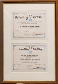 National Vietnam Veterans Museum (NVVM)
Document - Citation, Gallantry Cross, Republic of Vietnam
The Republic of Vietnam Cross of Gallantry with Palm Unit Citation was conferred by General Cao Van Vien, Chief of the Joint General Staff, Armed Forces of the Republic of Vietnam on 24 October 1970, and officially presented to the 8th Battalion Royal Australian Regiment by Lieutenant General Do Cao Tri, Commander of II Corps and Military Region 3 Vietnam on 29th October 1970. The citation was awarded for "always displaying high morale while co-operating and assisting the Vietnamese people in their struggle against Communism and to defend peace and freedom .. in Military Region III ... Though fighting under the most difficult conditions, the members of the 8th Battalion, 1st Australian Task Force still fought bravely and determinedly and had many glorious victories. Their most remarkable military operations took place in the area of the Long Hai hills... (They also participated ) ... in the civic action programme to assist the local population ( in Military Region 3) to reconstruct their houses, roads, bridges, markets and schools etc. ... thereby bringing great credit to the Royal Australian Armed Forces."2 X paper documents, one in English the other in Vietnamese (mounted with white matt in timber frame). Each has been printed with a decorative blue border, main text in black, official stamp in bottom right corner is red. A blue medal with red and yellow ribbon is printed in centre top of both documents.Republic of Vietnam/ Gallantry Cross/Chief of the General Staff? Armed Forces of the Republic of Vietnam/ Army Meritorious Commendation/ The 8th Battalion, 1st Australian Task Force/ For the gallantry they displayed under enemy fire./ This Meritorious Commendation ((GALLANTRY CROSS)) is added with (a) palm (leaf)./KBC day 24 month 10 Year 19708rar, koo, arthur koo, citation, gallantry cross, gallantry cross with palm -
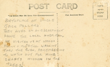 Ringwood and District Historical Society
Photographs, Collection of Pollard Photographs, Ringwood (Undated -probably early 1900's). Also Woods Point 1900, circa 1900
Pollard Photographs:; 1. Back of postcard of the Pollard home in Wonga Road (also called Anderson Creek Road Road, and now Warrandyte Road).; 2. One bushel net apples, J Pollard, Victoria, Australia.; 3. Joseph and Emma Pollard and Family. Emma is nursing baby Ethyl.; 4. Ringwood PS photograph. Jack Pollard is second from the RHS in the back row.; 5. Woods Point with arrow indicating mine manager's house: that of Joseph Pollard. Circa 1900. The Pollard family had a 20 acre orcharding property between Mullum Mullum Road and Wonga Road. Given on 4th September 2010 by Arthur Lunt from his cousin. The Pollard family. School photo at Ringwood State School. Jack�s father was Joseph � land (orchard) between Mullum and Wonga Roads +Additional Keywords: Pollard -
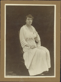 Kew Historical Society Inc
Photograph - Alice Maud Marsh
This photo of Alice Maud Marsh has traditionally been associated with the Marsh family that operated a butcher's shop on the corner of Edgevale Road and Fitzwilliam Street, Kew.Cabinet card. Studio portrait of Alice Marsh, J.E. Marsh whose family owned Marsh's Butcher Shop in Edgevale Road from 1915 to 1970. Previously the butcher shop had been owned by Mr Charlie Watson. Alice managed the shop until about 1928, when she became quite ill in about 1924 and died in 1930. The original donor, Nell Baker, who stated that .'..Alice could split lambs and breakup beef, no wonder she became ill!'BORN 29TH NOVEMBER 1877 / ALICE MAUD MARSH / DIED 2 JUNE 1930 / AGED (52) 52. Also photographed are two donation letters: that from Nell Baker to Mr Andrews [the current owner of the shop] in 1988, and from Diana Andrews [undated].alice maud marsh, marsh's butcher shop -- kew (vic.)