Showing 2399 items matching " structure"
-
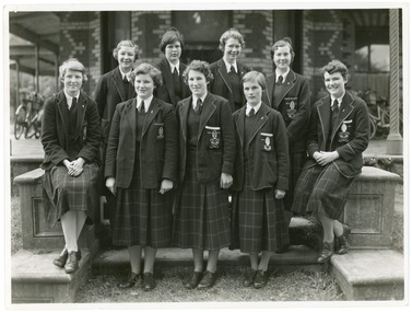 Ruyton Girls' School
Photograph, Ruyton Girls' School, 1951
Depicted are nine Ruyton Girls' School prefects for the 1951 school year. The image is a formal school portrait taken outdoors on school grounds outside of Henty House (formerly Tarring). In the background, we can see three bicycles with cane baskets. The students are all dressed in knee-length check skirts, a dark jumper, light-coloured collared button-up blouse with a dark tie, wool blazers, and dark coloured shoes. Four girls are standing in the back row, and five are positioned in the front row. Students in the back row have been identified from left to right as M. Murray, B. Addison, T. Abson and H. Cole; in the front row, from left to right we can see S. Backhouse, J. Wigg (Vice Captain), F. Jacobs (Captain), E. Duff, and A. Dickinson. The same photograph appears in the Ruytonian 1951. Student leadership commenced at Ruyton Girls' School in 1906 with the introduction of the prefect system. Prefects had numerous responsibilities—gate duty, grounds duty, classroom marking, assembly door watch, uniform monitoring, and even supervising student detention. In 1947, a dedicated Prefects Room was erected on the east side of the Ruyton Girls' School Assembly Room in Henty House. The prefects system was revised in 1968 with a new leadership structure: there would be a permanent School Captain, Vice Captain and School Sports Captain; six permanent prefects would be elected, and the rest of the Matriculation class would form committees. These included Library, Social Services, S.C.M., Editorial, and Music. In this way, it was thought "that each Matric girl would have a certain amount of responsibility." With this revised structure came a brand new Prefects' Study, located in a former classroom next to the Domestic Science building. Each prefect was allocated one book locker, one clothing locker, "a small share in the heater", plus a new shared lounge. The prefect system was updated again in 1974. All sixth formers would become prefects, or "school officials." This saw the sixth form divided into two halves: one group would be prefects for the first half of the year, then the second group would take the reigns in the latter half of the year. In October 2023, Ruyton announced a new collaborative leadership structure for captains, prefects and house leaders, which would see two students in each leadership role.The record has strong historic significance as it depicts a former notable student, Helen Gordon (maiden name Cole), pictured third from the right in the front row. Helen started at Little Ruyton in Prep 1940 and finished Year 12 in 1952 as School Captain, Bromby Captain, Form Captain for Matric, Tennis Captain, Hockey Captain, Swimming Vice Captain, and an award for Best All-Round Girl. She also played baseball for Victoria. After finishing school, Helen went on to graduate from the University of Melbourne as a physiotherapist in 1956. Her first position at age 19 involved setting up clinics with the Victorian Health Department Poliomyelitis Rural division. Helen’s strong ties to Ruyton continued when she held the position of President of the Old Ruytonians’ Association from the start of 1966 to the end of 1967. In 2019, Helen received an Order of Australia Medal for service to community health as a physiotherapist. She was also the recipient of the 2022 Victorian Senior Achiever Award at Parliament House. Helen passed away in July 2023 at age 88. The record's significance is further enhanced by its strong provenance, having been produced by Ruyton Girls' School and donated to the Archives by a familial connection.Black and white rectangular photograph printed on matte photographic paper.Reverse: Felicity Jacobs / Judi Olsen / Ann Dickinson / Bev. Addison / RGS011/1951/0004 /ruyton girls' school, ruyton, students, school, senior school, girls school, kew, melbourne, school uniform, prefects, photograph, henry henty, henty house, marion henty, tarring -
 Marysville & District Historical Society
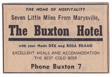
Newspaper (Item) - Newspaper advertisement, BUXTON HOTEL, 1950s
A newspaper advertisement regarding the Buxton Hotel in Buxton. Dex and Rosa Brand were the hosts at the hotel at the time of the advertisement. They, along with their children, Colin and Helen, ran the hotel in the 1950s. The Buxton Hotel was built by William Burchall, probably in the late 1870s. The first owner, who also had land locally, was Frederick Nichols (1833-1904). The Buxton Hotel is located directly opposite the General Store. It was fronted with two huge oak trees and bordered and backed by large pine trees. It was a weatherboard structure with a painted corrugated iron roof. Old split wood shingles were covered by corrugated iron, which overlaid the shingles to make the roof watertight. The wooden shingles date back to the 1850s.A newspaper advertisement regarding the Buxton Hotel in Buxton.buxton, victoria, australia, buxton hotel, accommodation, willam burchall, frederick nichols, advertisement, colin brand, helen brand, dex brand, rosa brand -
 Kiewa Valley Historical Society
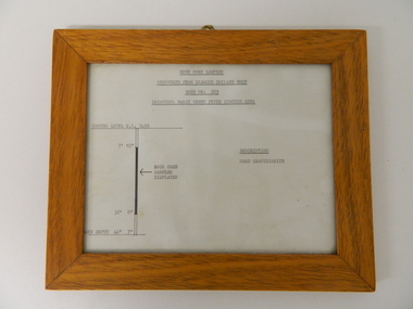
Sketch Rock Core Display, circa mid to late 1900's
This framed sketch details, in graphic form, where the core samples in the display cabinet were removed. The drilling was a precursor to the decision where to locate, in this case, the McKay Creek Power Station. The information gained by structural engineers from the core samples would be used also for the placements of underground tunnels entry and exit points and the overall effective size of the plant. This would have included drill and blast techniques(rock characteristics play an import part of explosion control), requirements for support structures and reinforcing cement/steel forms. The use and replenishment of diamond drill bits(the strongest available, see KVHS 0280) was dependent on the "type" of rock found. Support beams for reinforced ceilings and floors was also a necessity.The visual derails of where the rock core samples were removed is very significant in the formulation and placement of the underground Power Stations and their maze of tunnels(in and out) for a successful implementation of the Hydro Scheme. The amount of pre-planning and scientific studies required for such a large scheme must be undertaken to ensure that a "white elephant" was not the result.This framed and glass front rock core display sketch has type written information of the rock samples displayed in KVHS 0279 (A). It has a softwood stained and glossed frame with a fixed(nailed) back board and a brass fixture for mounting onto a wall.The paper and type are slighted faded (sunlight affected). The sign heading "ROCK CORE SAMPLES RECOVERED FROM DIAMOND DRILLED BORE" underneath this "BORE NO: 883" and below this "LOCATION: McKAY CREEK POWER STATION AREA" to the left a sketch incorporating the ground level point "GROUND LEVEL R.L.3493", and the core depth point "CORE DEPTH 40' 7". In between and representing( in visual form) the core location areain question.alternate energy supplies, alpine feasibility studies temperature, rainfall, sec, kiewa hydro scheme, electricity -
 Kiewa Valley Historical Society
Photograph of Lake Guy Dam, Spillway, Lake Guy Dam, c1945
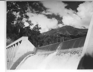
In December 1939 the excavation of the diversion tunnel at the site of Junction (Lake Guy) Dam was commenced and finished in February, 1940.This allowed the stream to be diverted to facilitate the dam wall construction. This is a 'slab and buttress' dam. It is framed with timber and concrete then poured into the structure. A contract was let to Lewis Construction Co. for the construction of the dam, and the first batch of concrete was placed in September, 1940. Industrial trouble caused some delays but there was also slow progress on the part of the contractor and the work was taken over by the S.E.C., terminating the contract. The dam was completed in March, 1944. The lake is named after Mr. L.T. Guy who was the Resident Engineer, in charge of construction work and associated activities on the Kiewa area, from 1939 until November 1946. An historical pictorial record taken for the State Electricity Commission of Junction Dam (Lake Guy) on spill. Mt. Arthur is in the background and there is still evidence of the destruction of trees from the 1939 bushfires. Black and white photograph of Lake Guy Dam . The dam is spilling and Mt. Arthur is in the background. Hand written on back of photograph in blue ink " Lake Guy Dam".dam, lake, water, mr. l.t.guy -
 Glen Eira Historical Society
Map - Victorian Railways
This file contains three items. 1. Original railways grid map of Victoria with passenger mileages (in miles) which shows railway stations in Glen Eira as part of the rail network. 2. Original pamphlet titled ‘Pocket History Vicrail 1839 – 1981’, dated 1981. Chronological history of milestones and dates, ie. 1981 Caulfield loop opened 24/01/1981 as part of underground rail loop. Image on front cover shows 2 images (steam train and stainless steel train). 3. Original pamphlet by Ministry of Transport titled ‘Your neighbourhood Public Transport System’ outlining fare structure. Stylised map of Caulfield (Glen Eira) neighbourhood.carnegie, bentleigh, caulfield, elsternwick, glenhuntly, ormond, murrumbeena, railways, public transport, bus, train, tram, railway stations, ‘vicrail’, underground rail loop -
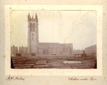 Federation University Historical Collection
Photograph - Photo, J.W. Mellor, St Michael's and All Angels church and cemetery, Ashton-under-Lyne
The Church of St Michael and All Angels dates from the 15th century and is the Parish Church for Ashton under Lyne. It is believed there was a church on this site before the Norman Conquest as the Domesday Book mentions a St Michael's Church in the east of the ancient parish of Manchester. Much of the structure was re-constructed in Victorian times. The church with large windows in Perpendicular style. Buttresses were required with this type of building as the large window area reduced the strength of the walls. The church boasts boasts some of the best examples of fifteenth century stained glass left in Britain. There are eighteen panels illustrating the life of St. Helena. The church tower is 145 feet high and has a peel of thirteen bells. (From ashton-under-lyne.com) .1) Sepia photograph mounted onto card showing St Michael's and all Angels church and graveyard in Ashton-Under-Lyne. The gravestones shown in the photograph are no longer evident today. The cemetery area is now covered with grass.cemetery, st michael s and all angels, ashton under lyne, j w mellor, church -
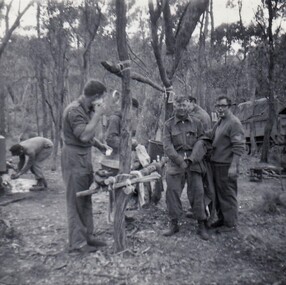 8th/13th Victorian Mounted Rifles Regimental Collection
Photograph
A bivouac area was a camp site occupied for a short period of days during a training exercise. Rudimentary structures might be erected.The 8th/13th Victorian Mounted Rifles was raised as a regiment of the Royal Australian Armoured Corps on 1 May 1948 with Headquarters in Melbourne and squadrons in Sale, Benalla/Wangaratta and Albury. In 1955 Regimental Headquarters moved to Wangaratta and a second squadron was located at Albury. The Sale squadron transferred to 4th/19th Prince of Wales’s Light Horse. In 1977 8/13 VMR Regiment was reduced to an independent squadron A Squadron 8th/13th Victorian Mounted Rifles and in 1991 was linked with 4th/19th Prince of Wales’s Light Horse forming the VMR Squadron of that regiment.Black and white photograph of group of 8/13 Victorian Mounted Rifles soldiers gathered around a wash point in a bivouac area during Annual cam9 1973. -
Kew Historical Society Inc
Archive (series) - Subject File, Victoria Park : Concept Management Plan, Research Papers, 2004, 2004
Graeme Butler & AssociatesProject FilesProvenance OrderRed cardboard wallet containing historical research by Graeme Butler, heritage architect, into the history of Victoria Park, Kew. The file also includes a draft Victoria Park Concept Master Plan, 2004. The research includes memoranda, maps, photocopies of plans, forms, notes, aerial photos, and sundry references.graeme butler - heritage architect, victoria park - kew (vic), heritage studies - kew (vic.)graeme butler - heritage architect, victoria park - kew (vic), heritage studies - kew (vic.) -
 Wodonga & District Historical Society Inc
Book - The Barren Jack Scandal and its Effects on the M.I.A, W. R. Cowper, 1987
This book outlines the issues and controversy around the construction of the Barren Jack (Burrinjuck) Water Supply Dam as part of the infrastructure of the Murrumbidgee Irrigation Authority (M.I.A) and its subsequent abandonment. It has now fallen into disrepair,non-fictionThis book outlines the issues and controversy around the construction of the Barren Jack (Burrinjuck) Water Supply Dam as part of the infrastructure of the Murrumbidgee Irrigation Authority (M.I.A) and its subsequent abandonment. It has now fallen into disrepair,irrigation -- government policy, murrumbidgee irrigation area (n.s.w.) -- history, barren jack dam, burrinjuck, yass valley -
 Eltham District Historical Society Inc
Slide - Photograph, Sensory Integration Invention A, Cathy Smith (1999), Fergusons Paddock, Arthurs Creek Road, Hurstbridge, c.Nov. 2001
Sensory Integration Invention A, by Cathy Smith public art sculpture, commissioned by Nillumbik Shire Council, in Fergusons Paddock,12 Arthurs Creek Road Hurstbridge was officially unveiled in 1999. Councillors Penny Mullinar and Margaret Jennings in attendance. "Smith's work has strong references to humans' sensory and practical relationship with the land through the built environment. Wind entering the structure's tubing operates like a flute, generating sounds such as bird calls that resonate into the surrounding wetland areas." Source: Highlights from the Nillumbik Public Art Collection, NSC, n.d. Part of a slide show presentation "A Trip Down the Diamond Creek" by Russell Yeoman to the Eltham District Historical Society meeting of 14 Nov. 200135mm colour positive transparency Mount - Black and Whiteart in public places, arthurs creek road, cathy smith, ferguson's paddock, hurstbridge, public art, sensory integration invention a -
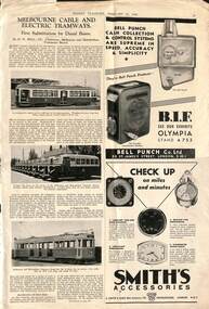 Melbourne Tram Museum
Magazine, Modern Transport, "Melbourne cable and electric tramways", 2/1939
Article - "Melbourne cable and electric tramways" - with the subheading "First Substitution by Diesel Buses", with H H Bell, MMTB Chairman as the author. Describes the current system, cable tram operation, formation of the Board, Chairman Bell, Cameron, conversion, H H Bell's tour, closure of the cable system and operation by diesel buses, the new SW6 tram, Australian PCC cars, Diesel bus development, Fare Structure and notes the Board's payments to the fire brigade etc. Has photos of Y 469, Leyland cub buses, W5 736. Has adverts for Bell Punch ticket machines, Smith's clocks and Karrier trucks. There is a report from Thomas Tilling Ltd about their operation and annual reporting.Yields information about Melbourne tramways in 1939 and the background history.Magazine cutting from Modern Transport 25/2/1939 - pages 43 and 44trams, tramways, mmtb, cable trams, buses, bus replacement, h h bell., melbourne, y class, w5 class, tram 469, tram 736, leyland cub -
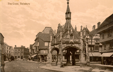 Federation University Historical Collection
Postcard - photographic, The Cross, Salisbury, c1918
The Poultry Cross is a market cross in Salisbury, Wiltshire, marking the site of former markets. It was built in the 14th century and modified in the 18th century. It stands at the junction of Silver Street and Minster Street. The Poultry Cross is the only one remaining of four market crosses that once existed in Salisbury. The presence of a market cross on the Poultry Cross site dates to 1307 and the name to about a century later. The present stone structure was built in the late 15th century. The original flying buttresses were removed in 1711, as can be seen in the painting of 1800 by JMW Turner; the present buttresses date from 1852–4, when the upper parts of the cross were rebuilt to the designs of the architect Owen Browne Carter.Black and white postcard of the architectural feature known Poultry Cross Salisbury, and the street around it. chatham-holmes family collection, poutry cross, salisbury, henry smerdon holmes -
Bendigo Historical Society Inc.
Document - 1925 CHRISTIAN'S COMMERCIAL CALENDAR, 1925
The Three C's, 1925 Christian's Commercial Calendar.with Compliments from A.Frigerio, Ironmonger and Wireworker,181 Mitchell Street, Bendigo. Guns, Ammunition and Fishing Tackle. In the centre is a 12 month calendar and surrounding it are 26 ''Alphabet'' Advertisements for different traders in Bendigo, A-Z. Designed by Ace Ad Service, Sydney and Melbourne. Copyright Reg. The Arcade Stores, H. Gittens, T Chamberlin, V. Broadway, William Dowel, Geo. Jalland, T.D.Cairns & Co., G.l.Bray, A. Frigerio, L.R.Hepworth, J.D.Kerr, Geo. Greaves, William Dowel, Paton's, B.T,Toy, H.Gittens, H.Greig, Warren's, Northern Seed Supply, W.Koska, P.Travenor, Frank Every, Warren's, Randall's, C.A.Waters, The Ace Ad Service. All of these traders had a small poem structured into their ad.Designed by Ace Ad Service, Sydney and Melbourne. -
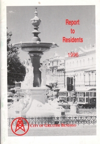 Bendigo Historical Society Inc.
Book - BOOKLET: REPORT TO RESIDENTS CITY OF GREATER BENDIGO, 1996
Front cover is a photo of Alexandra Fountain. 52 paged booklet - ''Report to Residents - City of Greater Bendigo, 1995. Table of Contents; The Mayor; Chief Executive Officer; Council meetings; Office location and hours; ''One Telephone Number''; Locations of functions and business; Units; Organisation Structure; Advisory Committee; Municipal Boundaries; Customer services; Economic development; Bendigo Tourism; Bendigo Trust; Events Bendigo; Capital works 1996/97; Bendigo Regional Arts Centre; Local laws; Aged and disability services; Children and family services; Environmental health; Recreation and leisure; Parks and gardens; Planning and building; Waste management in Bendigo; Library services; Rates; Budget for 1996/97; The budget at a glance; Index.bendigo, council, report -
 Kew Historical Society Inc
Photograph - Demolishing the Zig-Zag Bridge, 1929
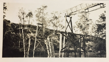
Henry Beater Christian (1886-1962) , was a descendant of one of the earliest settler families in Kew. Employed at the Kew Asylum as a 'public servant', he was a skilled amateur photographer, photographing numerous scenes in Kew and on his travels around Victoria. The majority of his photographs date from 1916 to 1929. His finest photographs are housed in two photograph albums. Rare photograph of the demolition of the Zig-Zag Bridge linking the two asylums on either side of the Yarra River.Digital copy of a photograph from page 16 of the 47-page photograph album containing 261 gelatinous silver images, loaned by Diane Washfold with permission given to digitise and hold a copy in our collection. The Zig-Zag Bridge linked the grounds of the Yarra Bend and Kew Asylums. The wooden bridge was constructed in the 1870s and lasted through numerous floods until its destruction in 1929. A horizontal structure, the walkway was reached via a wooden staircase on the Kew bank of the river. The steps were required due to the different levels of the banks on this stretch of the river. This is a photo of the bridge showing the level of destruction caused by the initial damage from the flood and subsequent dismantling of the horizontal struts and walkway, prior to to its destruction by fire."Demolishing Zig-Zag / 6. 1929"henry beater christian (1886-1962), landscape photography, kew (vic.) — yarra river, christian-washfold collection, photograph albums, zig-zag bridge -
 Kew Historical Society Inc
Photograph - Demolishing the Zig-Zag Bridge, 1929
Henry Beater Christian (1886-1962) , was a descendant of one of the earliest settler families in Kew. Employed at the Kew Asylum as a 'public servant', he was a skilled amateur photographer, photographing numerous scenes in Kew and on his travels around Victoria. The majority of his photographs date from 1916 to 1929. His finest photographs are housed in two photograph albums. Rare photograph of the demolition of the Zig-Zag Bridge linking the two asylums on either side of the Yarra River.Digital copy of a photograph from page 16 of the 47-page photograph album containing 261 gelatinous silver images, loaned by Diane Washfold with permission given to digitise and hold a copy in our collection. The Zig-Zag Bridge linked the grounds of the Yarra Bend and Kew Asylums. The wooden bridge was constructed in the 1870s and lasted through numerous floods until its destruction in 1929. A horizontal structure, the walkway was reached via a wooden staircase on the Kew bank of the river. The steps were required due to the different levels of the banks on this stretch of the river. This is a closeup view of the bridge showing the level of destruction caused by the initial damage from the flood and subsequent dismantling of the horizontal struts and walkway, prior to to its destruction by fire."Demolishing Zig-Zag / 6. 1929"henry beater christian (1886-1962), landscape photography, kew (vic.) — yarra river, christian-washfold collection, photograph albums, zig-zag bridge -
 Kew Historical Society Inc
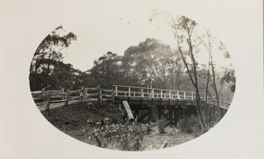
Photograph - Bridge near Bogong, c.1926
Henry Beater Christian (1886-1962) , was a descendant of one of the earliest settler families in Kew. Employed at the Kew Asylum as a 'public servant', he was a skilled amateur photographer, photographing numerous scenes in Kew and on his travels around Victoria. The majority of his photographs date from 1916 to 1929. His finest photographs are housed in two photograph albums. Digital copy of a photograph from page 34 of the 47-page photograph album containing 261 gelatinous silver images, loaned by Diane Washfold with permission given to digitise and hold a copy in our collection. John Chapman has written in 'Bushwalking Clubs - A Brief History', about the establishment in Victoria of the first bushwalking club in 1888, and the popularisation of bushwalking during the interwar period. Henry Christian's 'walks' appear to have been undertaken solely or with a companion/s. This black and white photo is part of a group of photos taken in the Victorian High Country. The page is labelled 'Bogong ****' and includes photos of landscapes, individuals, and built structures. This small black and white photo is of a wooden bridge near Bogong in Victoria in the mid-1920s."BOGONG [illegible]"henry beater christian (1886-1962), landscape photography, christian-washfold collection, photograph albums, bushwalking, northeast victoria, victorian high country, bogong -
 Kew Historical Society Inc
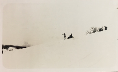
Photograph - Winter sports near Bogong, c.1926
Henry Beater Christian (1886-1962) , was a descendant of one of the earliest settler families in Kew. Employed at the Kew Asylum as a 'public servant', he was a skilled amateur photographer, photographing numerous scenes in Kew and on his travels around Victoria. The majority of his photographs date from 1916 to 1929. His finest photographs are housed in two photograph albums. Digital copy of a photograph from page 34 of the 47-page photograph album containing 261 gelatinous silver images, loaned by Diane Washfold with permission given to digitise and hold a copy in our collection. John Chapman has written in 'Bushwalking Clubs - A Brief History', about the establishment in Victoria of the first bushwalking club in 1888, and the popularisation of bushwalking during the interwar period. Henry Christian's 'walks' appear to have been undertaken solely or with a companion/s. This black and white photo is part of a group of photos taken in the Victorian High Country. The page is labelled 'Bogong ****' and includes photos of landscapes, individuals, and built structures. This small black and white photo is of individuals and groups skiing and toboganning near Bogong in Victoria in the mid-1920s."BOGONG [illegible]"henry beater christian (1886-1962), landscape photography, christian-washfold collection, photograph albums, bushwalking, northeast victoria, victorian high country, bogong -
 Kew Historical Society Inc
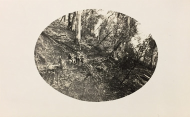
Photograph - Trekking near Bogong, c.1926
Henry Beater Christian (1886-1962) , was a descendant of one of the earliest settler families in Kew. Employed at the Kew Asylum as a 'public servant', he was a skilled amateur photographer, photographing numerous scenes in Kew and on his travels around Victoria. The majority of his photographs date from 1916 to 1929. His finest photographs are housed in two photograph albums. Digital copy of a photograph from page 34 of the 47-page photograph album containing 261 gelatinous silver images, loaned by Diane Washfold with permission given to digitise and hold a copy in our collection. John Chapman has written in 'Bushwalking Clubs - A Brief History', about the establishment in Victoria of the first bushwalking club in 1888, and the popularisation of bushwalking during the interwar period. Henry Christian's 'walks' appear to have been undertaken solely or with a companion/s. This black and white photo is part of a group of photos taken in the Victorian High Country. The page is labelled 'Bogong ****' and includes photos of landscapes, individuals, and built structures. This small black and white photo shows a group of trekkers on horseback near Bogong in Victoria in the mid-1920s."BOGONG [illegible]"henry beater christian (1886-1962), landscape photography, christian-washfold collection, photograph albums, bushwalking, northeast victoria, victorian high country, bogong -
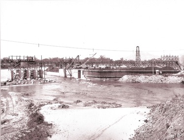 Wodonga & District Historical Society Inc
Album - Hume Reservoir Australia Album - Section of completed coffer dam, January 1927
This set of photos is from a leather bound album bearing the inscription "HUME RESERVOIR AUSTRALIA" plus 'The Rt. Hon. L. C. M. S. Amery, P. C., M .P.' all inscribed in gold. It was presented to The Rt. Hon. L. C. M. S. Amery, P. C., M. P, Secretary of State for Dominion Affairs on the occasion of his visit to the Hume Reservoir on 2nd November 1927. This album is of local and national significance as it documents the planning and development of the Hume Reservoir up to 1927. It was the largest water reservoir in the British Empire. The album records the pioneering engineering work that went into its construction.DEPARTMENT OF PUBLIC WORKS, N.S.W. RIVER MURRAY WATERS SCHEME. HUME RESERVOIR. 20. Section of completed coffer dam with river diverted over the concrete foundations of dam that were placed during the first stage of operations. New South Wales. January 1927. Cofferdams are temporary structures used where construction is being carried out in areas submerged in water. They are most commonly used to facilitate the construction or repair of dams, piers and bridges. To divert the river, a Coffer Dam was built across the old bed above and below the Dam site and tying into the end of the concrete wall built inside the levee bank. This completely surrounded the remainder of the site of the Dam and south wing wall, including an area of 12½ acres. hume reservoir australia, river murray waters scheme, hume reservoir construction -
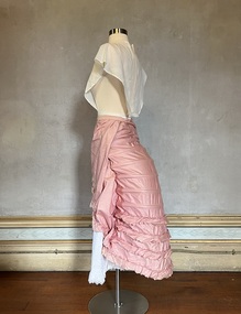 Kew Historical Society Inc
Clothing - Pink lobster-tail bustle, c. 1875
This full length lobster tail bustle was owned and worn by Alice Frances Henty, the daughter of Francis Henty and Mary Ann (Lawrence) Henty. Bustles of this form date from the mid-1860s however this example probably dates from the mid 1870s, and perhaps from before her marriage to John Hindson in 1876. Alice's father, Francis Henty, was the youngest son of Thomas Henty, who with his family, their retainers and property moved to the Australian colonies between 1829 and 1832. In 1834, Francis’ older brother, Edward, sailed from Launceston in Van Diemen’s Land to what was to become Portland in the western part of Port Phillip District [Victoria]. Francis, together with the first flock of Merino sheep [in Victoria], followed some months later. The first and second generations of the Henty family established vast pastoral properties in the Western part of the Port Phillip District. Francis Henty managed ‘Merino Downs’ near Casterton, while also living in his retirement at ‘Field Place' in Kew.The Henty Collection of nineteenth and twentieth century clothing, including outerwear and underwear, was collected, stored and exhibited over time by female family members descended from Francis and Mary Ann Henty. During the twentieth century, items from the collection were modelled in two fashion parades by various descendants [1937, 1959]. The items in the collection are historically and aesthetically significant, with provenance provided by oral and written tradition within or held by the family. A number of the items in the collection are very rare survivors, and provide researchers with the evidence needed to reconstruct the lives of notable women in the Port Phillip District [later Victoria] during the nineteenth and early twentieth century.An exceptionally rare and fine, floor length, 'lobster tail' bustle that belonged to Alice Henty possibly worn with her two-piece pink silk gown but also with other dresses that she owned that required a bustle of this shape. The structure of the bustle includes an outer layer of polished cotton with inserted steel hoops and ties at the front. The lower four hoops have flounces of the same fabric. Overall, the bustle contains 12 hoops, crossed nearer the waist and semi-circular for the remainder of the undergarment. [One of the tapes of the bustle is imprinted with the word lockstitch. Elias Howe invented the lockstitch sewing machine in 1846.] Measurements (mm): BUSTLE: Girth - Waist 660 Vertical - Front waist to hem 914, Back waist to hem 965.fashion -- 1870s, alice frances (henty) hindson, women's clothing, bustles, underwear -
 The Beechworth Burke Museum
Photograph, Late 1800s
This photograph was taken during the late 1800s at the Chinese camp at Beechworth, Victoria. It was in camps such as these that many would-be gold miners made their home after arriving in Australia from across Asia. After arriving in South Australia where there was no poll-tax required of migrants as was the norm in Victoria and New South Wales, those looking to settle on the gold fields walked en mass overland for hundreds of kilometres before arriving in destinations such as Beechworth. Due to widespread prejudice against Chinese gold diggers they were forced to live separate from the town and developed enclaves much like the one depicted in the photograph. As the years progressed the Chinese camp began to construct more permanent structures and included temples of worship, shops and separate burial grounds. This photograph demonstrates the early multi-cultural aspects of Australia and Victoria during the late 1800s. It also showcases pressures and prejudices specific to the Chinese migrant community and the measures taken to separate them from the rest of the predominantly white community. It also reflects the gold-rush period and one of the first draws to Australia due to its mineral wealth. Black and white rectangular photograph developed on paperObverse: None Reverse: From the/Chinese Camp/84-80-1/1997-3221chinese camp, beechworth, houses, immigrants, gold mining, gold rush, late 1800s, chinese, asia -
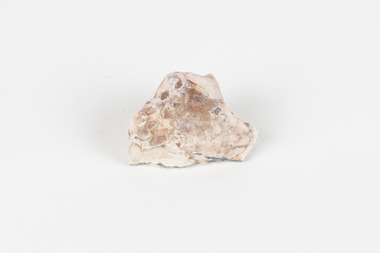 The Beechworth Burke Museum
Geological specimen - Opal Bearing Stone, Unknown
There are 17 opal fields in Australia. This opal bearing stone was found in Lightning Ridge, NSW over what is known as the Great Australian Basin. This basin was formed and covers an area of 1.7 million square kilometers in eastern Australia in the Cretaceous period. This basin used to contain an inland sea, which provided an environment where silcrete eventually formed when water levels changed. This eventually seeped into other structures, and eventually hardened and formed opal. Lightning Ridge has a population of around 2000 people, with about 80 000 visitors every year. It is a historic mining town, and is known for its deposits of a rare black opal. Mining started in the area in the late 1800s, early 1900s when the black opal was discovered. This opal-bearing stone is of social and historical significance. It is from Lightning Ridge, which is well-known for being a large producer of opal stones, most famously black opal. The history of the period dates back to 140 million years, with the discovery of black opal in the early 1900s causing interest in the area. This specimen is part of a larger collection of geological and mineral specimens collected from around Australia (and some parts of the world) and donated to the Burke Museum between 1868-1880. A large percentage of these specimens were collected in Victoria as part of the Geological Survey of Victoria that begun in 1852 (in response to the Gold Rush) to study and map the geology of Victoria. Collecting geological specimens was an important part of mapping and understanding the scientific makeup of the earth. Many of these specimens were sent to research and collecting organisations across Australia, including the Burke Museum, to educate and encourage further study.***A palm-sized solid mineral specimen in shades of beige and light orange*** silica based? burke museum, beechworth, geological, geological specimen, opal, opal fields, australia, lightning ridge, new south wales, great australian basin, cretaceous, silcrete, black opal, mining -
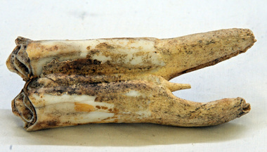 Orbost & District Historical Society
tooth
This was dug up at the old station at Lochend owned by the Stirling family and abandoned in the early 1870's. James Stirling's son Thomas Telfer Stirling took up the Corringle Run stretching from Lake Tyers along the coast. The home was at the Old Station. When he moved to Bruthen, James Stirling took over the Corringle Station. He is buried in the Marlo cemetery. He built a bark hut on the bluff that had two rooms, bark walls, earthen floors and a shingle roof. By 1884, this structure had expanded to a 9 roomed accommodation house and in 1886 became the Marlo Hotel when a liquor license was granted. info. from Personalities and Stories of the Early Orbost District by Mary Gilbert. The first settler to occupy the Marlo township area was James Stirling around the year 1875.An old horse tooth. Probably from before 1920. It is a molar.tooth stirling molar equine -
 Eltham District Historical Society Inc
Photograph, 68 Mount Pleasant Road, Eltham, c.1983, 1983
An early Alistair Knox design and build, this home was purchased by George Coop in 1968. Eltham builder, Graham Rose, extended the original Alistair Knox structure over the foundation excavation dug by George. Graham organised the brick walls where required, raised all frame work and laid the steel tray roof. George did all external/internal wall cladding, made all opening windows, sliding and swinging doors, stairs and general interior timber cabinet work. Bedroom wardrobe doors came from scrapped Victorian Railways country coaches. This particular view shows the original Alistair Knox design and materials. The photo was taken where the original external wall was located and knocked down to add the extension.Digital TIFF file Scan of 35mm Ilford XP1 black and white transparencyalistair knox design, eltham, graham rose, houses, mount pleasant road -
 Eltham District Historical Society Inc
Photograph, 68 Mount Pleasant Road, Eltham, c.1983, 1983
An early Alistair Knox design and build, this home was purchased by George Coop in 1968. Eltham builder, Graham Rose, extended the original Alistair Knox structure over the foundation excavation dug by George. Graham organised the brick walls where required, raised all frame work and laid the steel tray roof. George did all external/internal wall cladding, made all opening windows, sliding and swinging doors, stairs and general interior timber cabinet work. Bedroom wardrobe doors came from scrapped Victorian Railways country coaches. Most of the timbers used in the extension were re-purposed from the Templestowe Cool Store and the Port Melbourne wool, hide & skin store.Digital TIFF file Scan of 35mm Ilford XP1 black and white transparencyalistair knox design, eltham, graham rose, houses, mount pleasant road -
 Marysville & District Historical Society
Photograph (Item) - Black and white photograph, Unknown
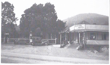
A black and white photograph of the Buxton Hotel in Buxton. Thomas David Robb (1886-1967), was the licensee at the time of the photograph. He, and his wife Alice May Evans, ran the Buxton Hotel for 25 years. The Buxton Hotel was built by William Burchall, probably in the late 1870s. The first owner, who also had land locally, was Frederick Nichols (1833-1904). The Buxton Hotel is located directly opposite the General Store. It was fronted with two huge oak trees and bordered and backed by large pine trees. It was a weatherboard structure with a painted corrugated iron roof. Old split wood shingles were covered by corrugated iron, which overlaid the shingles to make the roof watertight. The wooden shingles date back to the 1850s.A black and white photograph of the Buxton Hotel in Buxton.buxton, victoria, australia, buxton hotel, accommodation, photograph, william burchall, frederick nichols, alice may evans, thomas david robb -
 Marysville & District Historical Society
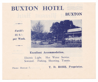
Ephemera (Item) - Advertisement, BUXTON HOTEL, Unknown
An advertisement regarding the Buxton Hotel in Buxton. Thomas David Robb (1886-1967), was the licensee at the time of the photograph. He, and his wife Alice May Evans, ran the Buxton Hotel for 25 years. The Buxton Hotel was built by William Burchall, probably in the late 1870s. The first owner, who also had land locally, was Frederick Nichols (1833-1904). The Buxton Hotel is located directly opposite the General Store. It was fronted with two huge oak trees and bordered and backed by large pine trees. It was a weatherboard structure with a painted corrugated iron roof. Old split wood shingles were covered by corrugated iron, which overlaid the shingles to make the roof watertight. The wooden shingles date back to the 1850s.An advertisement regarding the Buxton Hotel in Buxton.buxton, victoria, australia, buxton hotel, thomas david robb, alice may evans, accommodation, willam burchall, frederick nichols, advertisement