Showing 6749 items
matching gullies
-
 Bendigo Historical Society Inc.
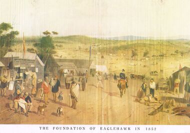
Painting - ST GILL GOLDFIELD PRINTS
6 ST Gill prints titled, [1] 'The Foundation of Eaglehawk in 1852. On the reverse of (1) is a pencil drawing named 'The Road To Allandale, Victor Cobb 1932, [2] Road from Forest Creek to Bendigo. [3] Fryers Creek near Castlemaine. [4] Tin Dish Washing. [5] Diggers Licensing Castlemaine Camps. [6] Eaglehawk Gully Bendigo. Reverse stamped Bendigo Branch Royal Historical Society of Victoria, 1959.bendigo, gold mining, s t gill prints -
 Bendigo Historical Society Inc.
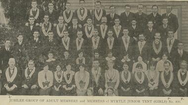
Document - INDEPENDENT ORDER OF RECHABITES, COBDEN TENT, CALIFORNIA GULLY, JUBILEE CELEBRATIONS 1865 - 1915
Buff coloured document, printed on front is a photo of a group of men and women, some wearing ceremonial collars. Printed on bottom ' Jubilee group of adult members and members of Myrtle Junior Tent (Girls) No. 400' On back of document ' Cobden Tent I.O.R. California Gully, Jubilee Celebrations 1865 - 1915, will be conducted from Sunday August 22 to Wed., August 25 in the California Hill, Methodist Church and Schoolroom'. Program of events is then described.bendigo, clubs, rechabites -
 Bendigo Historical Society Inc.
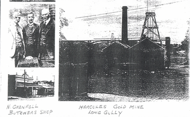
Photograph - LONG GULLY HISTORY GROUP COLLECTION: HERCULES GOLD MINE
Copy of a black and white photo of the Hercules Gold Mine, Long Gully, N Grenfell Butchers Shop and three men wearing suits all on the one page. Photos are very dark. The photo of the mine shows the chimney, poppet legs, a fence and buildings. The butcher shop has a veranda and above the veranda has the name Grenfell Butcher. The photo of the three men wearing suits are standing in front of a small table with an object resting on it.bendigo, history, long gully history group, the long gully history group - hercules gold mne, n grenfell -
 Bendigo Historical Society Inc.
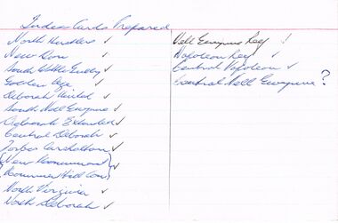
Document - SET OF INDEX CARDS - MINING
Set of Index Cards prepared (white lined) containing information on various mines - North Hustlers, New Don, South Wattle Gully, Golden Age, Deborah United, South Nell Gwynne, Deborah Extended, Central Deborah, Forbes Carshalton, New Monument, Monument Hill Consolidated, North Virginia, North Deborah, Nell Gwynne Reef, Napoleon Reef, Central Napoleon, Central Nell Gwynne. McColl, Rankin & Stanistreet Collection.topic, mining, companies -
 Bendigo Historical Society Inc.
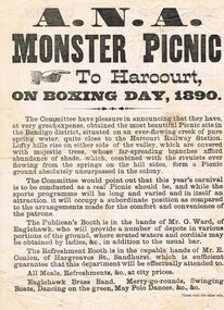
Document - A. N. A. MONSTER PICNIC 1890
Printed flyer announcing the A. N. A. Monster Picnic to Harcourt, on Boxing Day, 1890. There is a description of the picnic area, which was running the Publican's Booth and the Refreshment Booth, entertainment, and on the back the Monster Art Union 100 prizes, value £500. There is also a sports programme, details of train travel from Sandhurst, Eaglehawk, California Gully, Golden Square, Kangaroo Flat and Castlemaine. Also included are Railway Fare, Admission to Ground and a chance in the Art Union.event, social, a.n.a., a n a monster picnic 1890, harcourt railway station, mr g ward, mr e conlen, eaglehawk brass band, j e buchan -
 Bendigo Historical Society Inc.
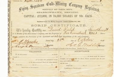
Document - LANSELL COLLECTION: SCRIP CERTIFICATE: FLYING SQUADRON GOLD-MINING COMPANY REGISTERED, 1870
Document: 2 copies of Scrip certificates from Flying Squadron Gold-Mining Company Registered, Woodfield and Pigeon Reefs, Sparrowhawk, Bendigo. Issued to David Field of Sandhurst, 26th. October, 1870. Signed by J.G. Weddell, Manager. David Field is listed as an original shareholder in the Flying Squadron Mine, in 1870. ( see Government Gazette October 7, 1870 ) The mine was situated at Sparrowhawk Gully, Sandhurst. ** one copy only in pocket. 8.10.2019place, fortuna, family history, bendigo, sandhurst, fortuna, lansell, david field -
 Bendigo Historical Society Inc.
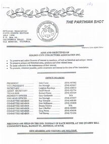
Newspaper - 'THE PARTHIAN SHOT ' NEWSLETTER FOR THE GOLDEN CITY COLLECTORS ASSOCIATION INC.JULY 1996
'the Parthian Shot ' Newsletter for the Golden City Collectors Association Inc. July 1996 / A4 stapled paper sheets / first page shows Official Logo / 54th Edition /Po Box 66 , California Gully Bendigo /-one of the aims of the Association -To preserve and collect firearms of interest to members of both historical and antique nature. / Includes the Association's submission to the Minister of Police Emergency services regarding the proposed changes to the current Firearms legislationorganization, club/society, golden city collectors association inc, the golden city collectors association inc / -
 Bendigo Historical Society Inc.
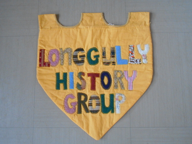
Textile - LONG GULLY HISTORY GROUP COLLECTION: LONG GULLY HISTORY GROUP BANNER
BHS CollectionYellow shield shape banner with three loops at the top for hanging on a dowel. Gold braid between the three loops. Different coloured (red stripe, red check, brown pattern, green, blue, floral, multi colour, dark blue, white and pink stripe and khaki) pieces of material cut into the letters of Long Gully History Group are sewn to the yellow background. It has a yellow backing with some filling between the front and the back.bendigo, history, long gully history group, the long gully history group - long gully history group banner -
 Ringwood and District Historical Society
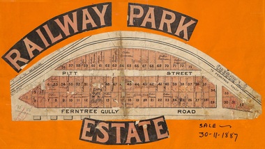
Flyer, Subdivision sale poster - Railway Park Estate, Ringwood, Victoria - 1887
Collage of clipped lettering and map pasted to orange coloured card depicting Railway Park Estate subdivision sale. Handwritten names associated with allotments and notation of sale date - 30 November, 1887. Subdivision plan with pink shading highlighting 73 allotments in Ferntree Gully Road (later Bedford Road) and Pitt Street, Ringwood. Handwritten names associated with allotments include Arthur Wiseman, T. Grant, J.J. Miller, M. Dickson, G.G. Miller, J. Frost, J.K. Turnbul, J.W. Davis, William Aldridge. -
 Bendigo Historical Society Inc.
Document - MINING REPORTS - THE MINING RECORD JAN., 1862
Photocopy of a printed 'The Mining Record' Jan., 1862 Pages 5 to 11. There is information on the Paddy's Gully Reef and the Sheep's Head Reef. The owners, area and title, workings, reef and yield, cost of working, drainage, machinery and remarks of the The Comet Company (formerly Cooper's Little Redan), Hogg, Tipper, & Milroy's Claim, Alliance Company, Watson & Wade's Claim, Barker & Co's Claim, Union Company's Claim, Paddy's Gully Reef Quartz Mining and Drainage Company's Claim, Picken and Co's Claim, Holmes and Co's Claim, Keith and Co's Claim, Stevens, Hasker & Co's Claim, Blewitt & Co's Claim, Thomson & Co's Claim, Hooper, Wills and Co's Claim, Union Company's North, or Lower, Claim, Sinclair and Co's Claim, Fogarty and Williams' Claim, Red, White and Blue Company's Claim, Union Company's Lower Whim Claim, Thompson's Claim, Union Company's Little Engine Claim, Will's Claim and the Union Company's South Claim.document, gold, mining reports, mining reports, the mining record jan., 1862, the comet company (formerly cooper's little redan), hogg, tipper, & milroy's claim, alliance company, watson & wade's claim, barker & co's claim, union company's claim, paddy's gully reef quartz mining and drainage company's claim, picken and co's claim, holmes and co's claim, keith and co's claim, stevens, hasker & co's claim, blewitt & co's claim, thomson & co's claim, hooper, wills and co's claim, union company's north, or lower, claim, sinclair and co's claim, fogarty and williams' claim, red, white and blue company's claim, union company's lower whim claim, thompson's claim, union company's little engine claim, will's claim, union company's south claim, john s mcnair, john mathieson, mr lomasney, mr kelly, mr clisshold, j b watson & co, milroy & price, hogg, tiper, millroy, mr ebden, mrssrs watson and wade, r o smith, edward hunt, h murdoch, samuel priestly, william goldsmith, david buchanan, robert anderson, bagshot company, barker, ladams, m'vey, claughton, gutteridge, good, cornell, simeon, rutherford, h jackson, murgatroyd, wormold, bashford, red white & blue claim, steven's and hasker's, blewitt and co, john blewitt, richard allingham, edward wills, john williams, richard williams, henry williams, joseph east, john thomson, thomas trownson, henry hooper, edward wills, thomas castelow, joseph castlow, william tongue, george nevinson, james griston, thomas porter, william a kenny, robert lisle, john sinclair, robert pritchard, william pritchard, thomas woods, james fogarty, daniel moon, william lindrea, john adams, brown, robert lisle, owen thompson, nicholson reef company, edward wills, p n russell & co, bendigo valley steam puddling company, metropolitan mills, bruce's, thos. woods -
 Bendigo Historical Society Inc.
Document - JOAN LEVERSHA COLLECTION: HOUSE PLANS 12 BOLT STREET, LONG GULLY
Various documents relating to the plan building of house at 12 Bolt Street, Long Gully. 1)Plan of proposed residence at Bolt Street, Long Gully for D. Dean Esq. job No. 133R plan drawn by A.S. and R.A. Eggleston Architects, 186 Mitchell Street, Bendigo. Stamp of the City of Bendigo approving the plan, signed by an official and dated 27/07/1950. 2) inside plan drawn in pencil and blue Biro, stamped by City of Bendigo and Bendigo Sewerage Authority. 3) Another drawing of section done in blue Biro. 4) Application for permit to construct No.4746. 5) Two pages on A4 paper written in blue pen, under the title City of Bendigo information for builders in regard to weatherboard buildings, long list of regulations to be followed, stamp of City of Bendigo and signature of D. Dean dated 27/07/1950. 6) small paper with various dimensions. All this documents are in a paper envelope marked Doug, house, 12 Bolt St.house, private, drawings -
Southern Sherbrooke Historical Society Inc.
Information folder - DeCoite family
Information folder containing items pertaining to the DeCoite family. Contents:- A3 photocopy of calendar with historical photos of DeCoites' blacksmith & iron works, Ferntree Gully. Order of service for John DeCoite's funeral service, Boyd Chapel, The Necropolis, Springvale, 26th April 2005. Card, from DeCoite family to Peter & Susan Downard, thanking them for their kindness re. John's death. Copy of speech delivered by Susan Heywood-Downard at the opening of the Society's launch of "Playing To Win" (Commonwealth Games exhibition), 2 Dec 2005 Photo, Betty de Coite, running Photo, John de Coite Jr, wedding Photos, various de Coite family photos. Photo, school group, inc. Betty de Coite. Telegram, dated 1947, congratulating Betty de Coite on a win, Article, "Farewell to an Anzac", Ferntree Gully Belgrave Mail, 29th April 2008. Order of service, funeral of Betty de Coite, 2015 (water damaged).decoites blacksmiths, jack decoite, bob decoite, john decoite, sir george knox, gus powell, moss trooper -
 Bendigo Historical Society Inc.
Document - MCCOLL, RANKIN AND STANISTREET COLLECTION: INDENTURE, GOLD MINING LEASE 11081 CROWN AND HERBERT JACKSON LEED OF BENDIGO, 21st September, 1940
6-page document plus map, dated 21st September 1940, between the Crown and Herbert Jackson Leed, for the land shown on the accompanying map 'indicated by yellow colour' Depths indicated on lease document. On map: Mining District of Bendigo, County of Bendigo, Parish of Sandhurst. No. 11081. Net Area 24 acres, 3 roods, 3 perches. Signed by Herbert Leed and ?Walsh, Warden Clerk, Bendigo. Map shows lease holding 11081 coloured yellow. Other leases: no's. 9882 11081, 11034, 11080. Streets: Fletcher Street, and Belle Vue Road. Gullies: Derwenters Mistake Bully and Pig Face Gully on lease 11081. Quarry Hill Recreation Reserve marked and some residential allotments. Water race indicated on map. On back of document: ; Deborah United Gold Mining Company No Liability of Charing Cross Bendigo is now the proprietor of the within described estate by transfer registered on 21st November 1940 and numbered 1795202.bendigo, mining, deborah united gold mine, herbert jackson leed, deborah united gold mining. major general sir winston joseph dugan -
 Eltham District Historical Society Inc
Photograph - Aerial Photograph, Landata, Eltham North, Feb. 1956
Centred on present day 54 Kelway Crescent, Eltham North bounded by Glen Gully Road to north, Meruka Drive to south, Eltham College to east and Leach Street to west. Historic Aerial Imagery Source: Landata.vic.gov.au Aerial Photo Details: Project No :250 Project : MELBOURNE OUTER SUBURBS PROJECT Run : 17 Frame : 113 Date : 02/1956 Film Type : B/W Camera : EAG9 Flying Height : 10000 Scale : 12000 Film Number : 1176 GDA2020 : 37°42'16"S, 145°08'08"E MGA2020 : 335650, 5825336 (55) Melways : 21 G2 (ed. 42)aerial photo, 1956-02, eltham, eltham north, glen gully road, leach street, main road, melway 21g2, meruka drive, montmorency, neil webster collection -
Glenelg Shire Council Cultural Collection
Photograph - Contact Print - Portland, 1900s
Sheet of 6 contact prints from glass plate negatives. Top 2: Stereoscopic pair of prints showing several couta boats and a lighter on Henty Beach. Railway Pier and Ocean Pier in background. Middle: Two slightly different views of several men, some in costume with musical instruments. One man with wooden leg, one with arm in sling. Bottom left: Two men in woodland setting. Right: Group of people at Jackass Fern Gully.portland photography, henty beach, jackass fern gully, camping, recreation, seafront, couta boats -
 Bendigo Historical Society Inc.
Document - H.A. & S.R. WILKINSON COLLECTION: CONTRACT OF SALE
Contract of sale of land dated 11th October 1956 between Estate of J.N. Neilson deceased (seller) and Mrs. H.F. Redwood (buyer) for land being part of the Roman Catholic Church Reserve at Long Gully being land described in certificate of title volume 2653 folio 419, together with all buildings thereon also all linos, blinds and curtains in the dwelling. Price 1,600 pounds. Attached 3 pieces of paper with drawing in pencil of the land.organization, business, h.a. & s.r wilkinson real estate -
 Bendigo Historical Society Inc.
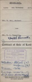
Document - H.A. & S.R. WILKINSON COLLECTION: CONDITION OF SALE
Contract of sale of land issued by H.A. Wilkinson and dated 4th November 1952 between Mr. K. McL. Michael (seller) and Mr. W. A. Runnalls for land being allotment 521 section M, Borough of Eaglehawk, Parish of Sandhurst County of Bendigo described in Crown grant volume 6071 folio 124 situate No. 23 Nelson Street California Gully, together with 5-roomed brick dwelling and all sundry. Price 1,950 pounds.organization, business, h.a. & s.r wilkinson real estate -
 Bendigo Historical Society Inc.
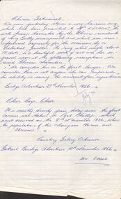
Document - CHINESE TESTIMONIAL
Extract from the Bendigo Advertiser 27th November 1856 mentioning a ring which was presented to Mr Lysaght, a barrister for his work for the Chinese residents of Long Gully encampment. The ring was manufactured for the occasion and had an inscription in raised Chinese characters. The second extract from the Bendigo Advertiser 14th November 1856 Courtesy Geelong Observer mentions that it was twenty years since the first census was taken in Port Phillip which occurred on the 8th November 1836.document, chinese testimonial, mr lysaght, bendigo advertiser 27th november 1856, port phillip census, geelong observer, bendigo advertiser 14th november 1856, ben eagle -
Bendigo Historical Society Inc.
Document - NORTH DEBORAH MINE - NOTES ON THE NORTH DEBORAH MINE
Handwritten notes:- Deborah Mine now North Deborah No 2 Shaft. 1st Winding engine. 2nd Winding Engine Roberts & Sons built 191-. Shifted to Deborah. Poppet Legs - Tubular Steel with four rivetted flanges. Came from Sebastion where they had not been erected, and originally from the Windmill Hill Mine, Long Gully. Built by Thompson & Co Engineers, Castlemaine. Ref. for poppet legs - Annual Reports 1895 Page 61.document, gold, the north deborah gold mine co, north deborah mine, notes on the north deborah mine, north deborah no 2 shaft, roberts & sons, windmill hill mine, thompson & co engineers castlemaine -
 Bendigo Historical Society Inc.
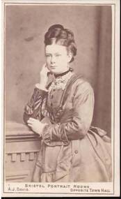
Photograph - PORTRAIT OF A LADY
Small, hip length portrait of a lady. She is standing beside a cupboard? With her right elbow resting on the cupboard and her hand up to her face. Her left hand is beside her right elbow. Her dress has long sleeves and lace at the collar and cuffs. Printed on the back in gold is the photographer's name and address. Also handwritten: - 'to Mrs Carson with my best love Angelina Moorhead. Sailors Gully. Feb 21st /7 5.'The Briston Portrait Rooms, A. J. Davis, 75 & 77 Swanston Street. Melbournephotograph, portrait, female, portrait of a lady, bristol portrait rooms, a j davis -
 Bendigo Historical Society Inc.
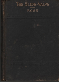
Book - ALBERT RICHARDSON COLLECTION: THE SLIDE VALVE
Black cover 32 page book, title in gold print on front; 'The Slide Valve, Rose' Inscribed on flyleaf ' George A.E. Richardson, Engine Driver,Long Gully. Green circular stamp ' Royal Historical Society of Victoria, Bendigo Branch'. Book published in 1895 by Henry Carey Baird & Co., Industrial publishers, Booksellers and Importers, 810 Walnut Street, 1895'. Includes a catalogue of practical and scientific books published by Henry Carey Baird & Co.Joshua Rose, M.E.person, bendigo, george richardson -
 Bendigo Historical Society Inc.
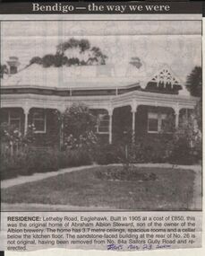
Newspaper - JENNY FOLEY COLLECTION: RESIDENCE
Bendigo Advertiser "The way we were" from 1999. Residence: Letheby Road, Eaglehawk.. Built in 1905 at a cost of 850 pounds, this was the original home of Abraham Albion Steward, son of the owner of the Albion Brewery. The home has 3.7 metre ceilings, spacious rooms and a cellar below the kitchen floor. The sandstone faced building at the rear of N. 26 is not original, having been removed from n. 84 Sailors Gully Road and re-erected.newspaper, bendigo advertiser, the way we were -
 Bendigo Historical Society Inc.
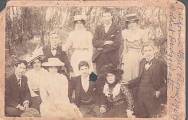
Photograph - HARRY BIGGS COLLECTION: CALIFORNIA HILL PICNIC, October 22 1901
Photograph of five men and five women, all young with a bush landscape in the background. The men are all dressed in formal suits with ties or bow ties, the women are all in long dresses and pretty hats. Written on the side of the photo in biro is: California Hill picnic 1900, held at Bridgewater. On the reverse in biro is:'S. Hercus 'Hiltondale?' 63 Mt. Korong Rd. California Gully, also printed on the reverse is : R. Dermer Smith, Photographer Bull St. BendigoR. Dermer Smith, Bull St. Bendigoperson, group, picnic group, california hill picnic 1901, r. dermer smith, bull st. bendigo, s. hercus 63 mt. korong rd. california gully -
 Southern Sherbrooke Historical Society Inc.
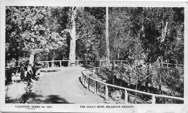
Postcard - The Gully Bend, Belgrave Heights
B&W postcard, Valentine Series No. 3831, 'The Gully Bend, Belgrave Heights'. Photo shows a small group of women and children walking along a horseshoe-shaped section of road which has wooden railings along both sides. One woman is standing beside a child's pusher. There are tall trees on the far side of the road and scrubby trees and bushes on the right, lower side. On the back of the postcard is a written message that has been obscured with white-out. -
 Bendigo Historical Society Inc.
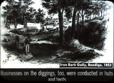
Slide - DIGGERS & MINING. DIGGERS AND MINERS, c1852
Diggers & Mining. Diggers and miners. S.T.G. Iron Bark Gully, Bendigo, 1852. Businesses on the diggings, too, were conducted in huts and tents. Slide depicts the huts and tents at the diggings in which business was conducted. This view you can see there are still quiet a number of trees in the surrounding area, there is also a fence. Miners can be seen walking amongst the tents and huts as well as on the hillside. Markings: 36 994:LIF I. Used as a teaching aid.hanimounteducation, tertiary, goldfields -
 Bendigo Historical Society Inc.
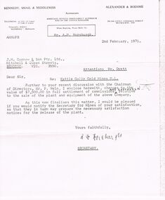
Document - IAN DYETT COLLECTION: LETTER TO MR DYETT
Copy of a letter to Mr. Dyett of J. H. Curnow & Son Pty . Ltd. Re: Wattle Gully Gold Mines N. L. mentioning two enclosed cheques in full settlement of commissions and expenses relative to the sale of the plant and equipment of the Mine. He requests that Mr. Dyett notify the Secretary for Mines of his satisfaction so they can prepare the necessary satisfaction notices for the release the plant. Dated 2nd February, 1971 and signed by A. M. Horsburgh.business, auctioneers, j h curnow & son pty ltd, ian dyett collection - letter to mr dyett, kennedy smail & middlemiss, alexander & boehme, mr a m horsburgh, j h curnow & son pty ltd, mr dyett, wattle gully gold mines n l, mr p wein -
 Bendigo Historical Society Inc.
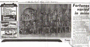
Newspaper - LONG GULLY HISTORY GROUP COLLECTION: KOCK'S MINE WORKERS
The initial partnership in a quartz crushing plant between Henry Koch, Simon Albert and Charles Wallin was dissolved in 1860 with Koch becoming the sole owner. In 1866 the crushing plant consisted of a 50 hp engine and 48 stamping heads capable of crushing 600 tons of quartz per week. By 1902 there were 72 stamps and this was by far the largest crushing plant in the area, serving many quartz mines. Henry Koch (1800-1889) was a German sailor who signed off when his ship reached Melbourne in 1851. Having heard of the gold discovery he proceeded to Bendigo where he was initially employed in puddling in the Myers Flat area. He was soon employed and then made partner in a quartz crushing plant that he became sole owner of in 1860. He was also landlord at the British and American Hotel and the Silver Mines Hotel. HE also started the Perseverance United gold claim. He married Anna Maria Theresia Heinz in 1857. In 1872 he sold the crushing plant for 75,000 pounds and took his family back to Germany. He resumed his trade as a ship builder although he maintained many Bendigo mining interests.Photocopy of an article from the Bendigo Advertiser, dated 5/5/1982 titled Fortunes carried in mine. Written above the photo is: Men from Kock's Mine Long Gully. One man is wearing a suit and the rest are in work clothes. The mine was worked, with some breaks, between 1857 and 1871 when the Pioneer Company took over, and was later known as Koch's Pioneer and Perseverance and worked continuously until 1924, a period of 53 years of uninterrupted mining.bendigo, history, long gully history group, the long gully history group - kock's mine workers, bendigo advertiser 5/5/1982, kochs pioneer mine, henry koch, havilah company's claim, garden gully line of reef, paddy's gully line, koch's pioneer and perseverance -
 Ringwood and District Historical Society
Photograph, Warrandyte Historical Society Newsletters nos. 68-75
Digitised WHS newsletters from August 1989 (no. 68) to October 1990 (no. 75). Sent to Secretary of the Ringwood Historical Research Group, Jack Lindsay.Noteable articles:- Warrandyte Primary School Artists (Clara Southern, Jo Sweatman) Potter's Cottage Architects Frank Crozier (artist) Warrandyte State Park Harris Gully Road Warrandyte Royal Women's Hospital Auxiliary Warrandyte Trade Directories 1899-1908 Gold nuggets in Warrandyte Gold mining in Warrandyte 1859-60 -
 Mt Dandenong & District Historical Society Inc.
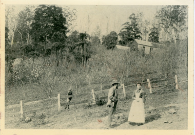
Photograph, George Dodd With Daughter Jessie 1890, 1890
1890 picture of George Dodd and his daughter Jessie (Mrs Ebbels) with the Dodd home in the background. The descriptive text on the reverse of this photograph was hand written by John Lundy-Clarke.1890 picture of George Dodd with his daughter Jessie (Mrs Ebbels) with the Dodd home in the background. Remains of the house were burned in the bushfires between 1910 and 1926 when Alan grandson of George and his wife Vera, nee Devine, started to build their home on the same spot and developed the present extensive flower farm “Rainbow Gully”.george dodd, jessie dodd, jessie ebbels -
 Eltham District Historical Society Inc
Photograph - Aerial Photograph, Landata, Research, Vic, Apr. 1972
Centred on present day Main Road, Research near Maroondah Aqueduct and Eltham College bounded by Allendale Road to north, Research-Warrandyte Road to south, Swipers Gully Training Restaurant to east and Reynolds Road to west. Historic Aerial Imagery Source: Landata.vic.gov.au Aerial Photo Details: Project No :985 Project : MELBOURNE 1972 Run : 26 Frame : 194 Date : 04/1972 Film Type : B/W Camera : RC10 Flying Height : 5700 Scale : 9600 Film Number : 2636 GDA2020 : 37°42'07"S, 145°11'07"E MGA2020 : 340015, 5825692 (55) Melways : 22 H1 (ed. 42)aerial photo, neil webster collection, 1972-04, allendale road, eltham college, main road, maroondah aqueduct, melway 22h1, research (vic.), research-warrandyte road, reynolds road, swiper's gully