Showing 17001 items
matching plenty-river
-
 Lakes Entrance Regional Historical Society (operating as Lakes Entrance History Centre & Museum)
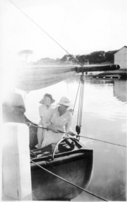
Photograph, A Cooper, 1908 1909 c
Reference from Gippsland in Focus, Debra Squires, Linda Barraclough, Helen ClothierBlack and white photograph of a motor boat on Tambo River with four people on board Tambo VictoriaTambo River A Cooper photojetties, waterways -
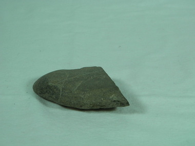 Bright & District Historical Society operating the Bright Museum
Axe Stone
Presence of Aboriginal people and their activities in Buffalo RiverAboriginal axes are relatively uncommon in North East Victoria and provide evidence of presence and exploitation of resourcesground edge stone axe with some edge damage and edge polish on working edge and flat opposite edge. axe, aboriginal artefact, buffalo river -
 Kew Historical Society Inc
Photograph - Submerged houses in River Avenue, North Kew, 1934
North Kew, now divided between Kew and Kew East, bordered the Yarra River. As such, it was a region subject to flooding in the Yarra Valley. Development beyond this point (ie Kellett Grove) was limited by the City of Kew's planning regulations. Prior to urban development, the area since European settlement and the first land sales in the district in the 1840s, had been used for dairy farming. Vivid photograph contrasting domestic life and relationships with natural disasters such as the flood of 1934.Small sepia snapshot of two submerged houses belonging to local families in River Avenue, North Kew, during the 1934 floods. The view is presumably from near Kellett Grove looking north towards Fairfield.Verso: COES & HYATTS ROOF / RIVER AVENUE / Stamped: 6414yarra river -- north kew, floods -- yarra valley, floods -- north kew, floods -- 1934, natural disasters -- kew -
Lakes Entrance Regional Historical Society (operating as Lakes Entrance History Centre & Museum)
Postcard, Bulmer
Black and white postcard of Snowy River at Basin Ranch with two men in foreground pointing to high cliff across the river Gippsland VictoriaSnowy River at Basin Ranch H D Bulmer photofires -
 Port Fairy Historical Society Museum and Archives
Photograph
Moyne River Scene January 1944 Subjects unknownBlack and white photograph of Two ladies at stern of boat fishingmoyne river, fishing, port fairy, boat -
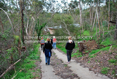
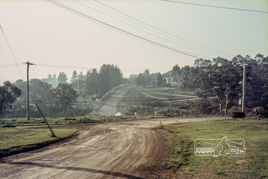 Eltham District Historical Society Inc
Photograph, Russell Yeoman, Para Road, c.1969, 1969c
Looking north from behind the Lower Plenty shops at Main Road and Para Road.Digital file only; created from original colour positive slide transparencystreets, lower plenty, para road, russell yeoman collection -
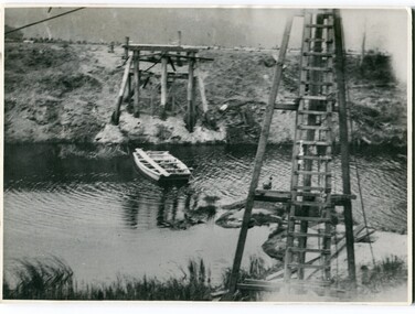
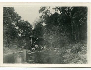 Orbost & District Historical Society
black and white photograph, C1890
This snagging team is on the Brodribb River, east of Orbost. The Brodribb bridge can be seen in the background of the Photograph. The Snowy River was used for commercial navigation after 1880 and extensive de-snagging A shipping company was formed in 1880, poling barges upstream until the removal of large trees and branches that had fallen into the river was carried out to make the river upstream of Marlo easier to navigate. "The snaggers played an important part in making the river free for transport. By 1880 Captain Collins, R McNair engineer, J McNair and the two Winchesters were at work with a punt on the Snowy and Brodribb. Mr. Jim Winchester took charge soon after. Early snaggers were Johnston, J Renton, Nat Lynch, John Drew, Hatton, J Scott and Harry Wilkinson. The system used was to use a tree on the river bank as a lever and with heavy manila ropes, slowly to haul the snags out. They were piled up around a tree and burned when dry. The snaggers lived in a row of cottages in Snaggers’ Lane." (info. John Phillips Newsletter March 2004)The snaggers played an important role in the early settlement of the Orbost / Marlo district helping bto open it up to commercial shipping.Two copies of a black / white photograph of nine men on a snagging boat, a flat-bottom barge. In the background is a bridge.on back - "Snagging boat on Brodribb with R.McNair"snaggers-brodribb-river snagging-east-gippsland transportation -
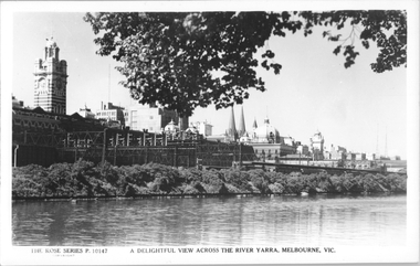 Melbourne Tram Museum
Postcard, Rose Stereograph Co, "A delightful view across the River Yarra, Melbourne"
Rose Series postcard No. P 10147, titled "A delightful view across the River Yarra, Melbourne" showing a view from the south bank of the Yarra across to Flinders St station, the signal gantries at the west end of the platforms, the station buildings and some of the other buildings on the skyline. A St Kilda bound dog box (swing door) set is in platform 10 awaiting departure.Yields information Flinders St station from the south side of the river.Postcard - printed real photograph with Rose Stereograph Co. name on the rear.flinders st station, signals, yarra river, railways, electric trains -
 Robin Boyd Foundation
Slide, Robin Boyd
Colour slide in a mount. Torrens River, Adelaide, South Australia, AustraliaMade in Australia / Adelaide (Handwritten) / River (Handwritten)adelaide, slide -
Lakes Entrance Regional Historical Society (operating as Lakes Entrance History Centre & Museum)
Postcard, Rose Series P531, 1970 c
Black and white postcard of the Icicles a statectite formation in the Bruthen Caves 05305.1 Photo by Bulmer Donor Max Davenport 16 March 2019Black and white postcard of the peaceful Snowy River near Bruthen VictoriaA Glimpse of the Snowy River near Bruther Viccamping -
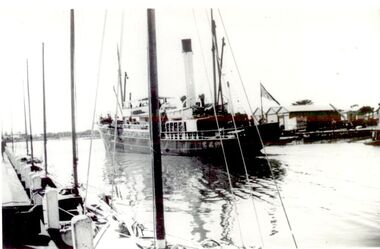 Port Fairy Historical Society Museum and Archives
Photograph
Iron Steamship SS Casino in the Moyne River (sank at Apollo Bay in 1932)Black & white photograph of ship near wharfboat, sea, river, ss casino, moyne river, steamer -
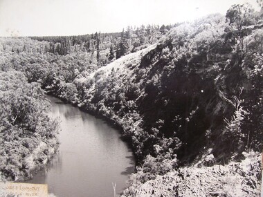 Glenelg Shire Council Cultural Collection
Photograph - Photograph - Jones' Lookout, n.d
Glenelg Shire Council records Portland Development Committee.Photograph of Jones Lookout, Glenelg River.Front: Sticker bottom left. 'Jones' Lookout Glenelg River' - penjones lookout, portland, scenery -
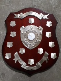 Vision Australia
Photograph - Image, Lifetime, Association for the Blind : Vision Victoria River Run Perpetual Shield
A brown wooden award with a banner engraved 'Association for the Blind' at the top of the shield, a large metal plate with a laurel wreaths and relief of a man starting to run in the middle. At the base is another banner inscribed 'Perpetual Shield Vision Victoria River Run'. 12 smaller shields frame the central plate, with names on two of them: 1990 Mike Hillardt 31.39 and 1991 Amon O'Callaghan 31.49. Wooden shield with 12 mini shields, banner and image of runner in centreassociation for the blind, mike hillardt, amon o'callaghan -
Lakes Entrance Regional Historical Society (operating as Lakes Entrance History Centre & Museum)
Postcard, W S Vogt Bairnsdale, 1918 c
Black and white postcard showing township, roads and rail, bridges and barked trees with cultivated land beside Tambo River Bruthen VictoriaTambo River at Bruthenjetties, waterways, topography, boats and boating -
 Orbost & District Historical Society
black and white photographs, 1915
This photograph is of the construction of the first road bridge over the Genoa River - 1915. Before today's timber truss and concrete bridge was constructed between 1926-1928 by contractor J.T. Noble Anderson, two earlier bridges crossed the Genoa River at this location. They provided crucial links in the Princes Highway route from Melbourne to Sydney. The letter on the back of the postcard was written by Gordon ? to Alex ? on 2nd October 1917. "this represents the opening of Genoa Bridge. Mrs Alexander cutting the ribbon and Mr Martin holding it at the other side. Did most of the speaking. The gent holding the roll of paper is who came to open the bridge. I can't think of his name. Hubert is standing up at the right / Gordon " This is a pictorial record associated with the history of Genoa in East Gippsland.1100 -A large black / white photograph on a cream coloured buff card. It is of an unfinished bridge with men working there. A small rowboat can be seen on the far side of the river. 1100.1 - A photograph / postcard of the opening of "Genoa Bridge 1917". There is a ribbon stretched across the timber decking road in front of a group of people. 1100.2 - A black / white photograph of a road bridge across a river.on back - "Princes Highway - the 1st bridge over the Genoa River - 1915" on back of 1100.1 is a hand-written letter.genoa-bridge princes-highway-east-gippsland -
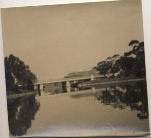 Kew Historical Society Inc
Photograph - Morell Bridge, Yarra River, circa 1953
This is one of a series of 17 black and white undated photographic proofs donated to the Kew Historical Society in 2013 by the Queenscliffe Historical Museum. The series includes images of individuals, tea rooms, ferries, motor launches, ocean liners and tugs. Faded black and white photographic positive proof of the Morell Bridge (formerly the Anderson Street Bridge) across the Yarra River near the Botanical Gardens. Princess Bridge can be seen through the arches of the Morell Bridge. The undated photographic positive was probably taken in the 1950s.melbourne, transport, bridges -- yarra river, morell bridge, anderson street bridge, yarra river -
 Greensborough Historical Society
Mixed media - Folder containing photographs and disc, Family photos of Chapman and Stock families, 1860o
A collection of photos of the Chapman and Stock families of Greensborough and Lower Plenty.Photos and letters have been digitised by Peter Blackbourn as part of his family history research.Compact Disc. Contains 95 images of Chapman, Stock, Blackbourn and Barnett families dating from late 19th century through the 20th century. Also printed copies of photographs.Greensborough and Lower Plenty photos from Chapman and Stock familiespeter blackbourn, chapman family, stock family lower plenty, chapman stock family -
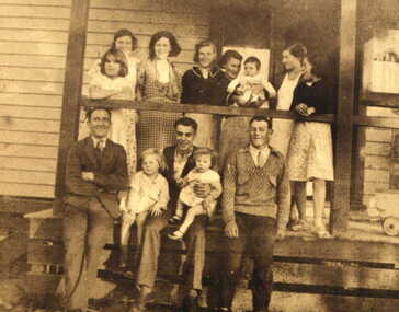
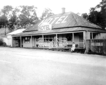 Eltham District Historical Society Inc
Photograph, Daughter of the owner, Miss Irene Browne, sitting on the verandah of the Lower Plenty Hotel, c.1940-c.1943
Sidney and Ivy-Jane Browne purchased the Lower Plenty ‘Golf Club’ Hotel in 1940. They owned it until 1943. Their daughter, Irene Stella, was born in Eltham in July 1923 and would have been between 17 and 20 years of age at the time this photograph was taken. Ivy-Jane (nee Williams) was born in Eltham in December 1899 and was the sister of George Alfred Williams who is commemorated on the WWI plaque at the back of St. Margaret’s church, Eltham, and whose name is also listed on the Cenotaph in front of the Eltham War Memorial in Main Road, Eltham. Irene Browne married Leslie Allan Walker in 1945 and following his death in 1958 she married Charles William Smith. She died in 2008 and is buried in Omeo Cemetery along with her husband, Charles Smith. Her granddaughter, Veronica Gunn, advises a few years earlier, Irene’s son took her to the hotel and spoke with the then owner who showed Irene the photo, which she confirmed was of herself. Digital filelower plenty, lower plenty hotel, hotels, irene stella browne, irene stella smith, golf club hotel, 1940s -
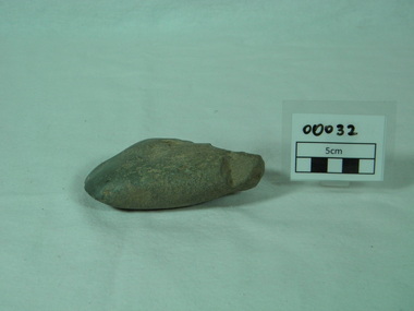 Bright & District Historical Society operating the Bright Museum
Axe Stone
Evidence of Aboriginal presence and activities in Buffalo River Valley near site of present Buffalo Dam.Evidence of Aboriginal presence and activities in North East and Alpine areas relatively uncommon.quartzite ground edge stone axe with edge damage axe, aboriginal artefact, buffalo river -
 Eltham District Historical Society Inc
Photograph, Fay Bridge, Ancient Eel trap on the Yarra River at Laughing Waters, Eltham - pre-dating European settlement, 6 September 2023
Laughing Waters is the name for a stretch of the Yarra Valley Parklands consisting of river flats and hilly riparian bushland. With Birrarung (Yarra River) flowing through, Laughing Waters has been an important gathering place for thousands of years. For the Wurundjeri, ‘Garambi Baan’ (the name for Laughing Waters in Woi wurrung) is an important site for growing and harvesting food. Significantly, Wurundjeri iuk (eel) traps remain at Garambi Baan to this day. The Wurundjeri Woi Wurrung People take their name from the Woi wurrung language word ‘wurun’ meaning the Manna Gum (Eucalyptus viminalis) which is common along ‘Birrarung’ (Yarra River), and ‘djeri’, the grub which is found in or near the tree. Wurundjeri are the ‘Manna Gum People’ and their Ancestors have lived on this land for millennia. The site on the Yarra River near the former Morrison property Killeavey was given a language name in 2015 at the instigation of Wurundjeri Elder, Dave Wandin. Garambi Baan means “laughing waters” in the traditional language, Woi wurrung. The site at Warrandyte was rediscovered by Campbell Beardsell OAM in 2007 and is one of only a few known remaining iuk (eel) traps on Country once found the length of the Birrarung (Yarra) and the Maribyrnong. Original Indigenous aquacultural infrastructure was dismantled, taken away from sites and used to build houses, fords and roads by Europeans. The difficult and restricted access to this site is thought to be one of the reasons for its survival. The iuk trap is located within lands managed by Parks Victoria. The Narrap team in partnership with Parks Victoria and Acacia Land Management have been improving the native vegetation with a program of woody weed removal, exclusion fencing and revegetation. Importantly, the team have restored the trap’s infrastructure and have demonstrated its effectiveness.” References: Wurundjeri Woi Wurrung Cultural Heritage Aboriginal Corporation - Laughing Waters. (2023, September 3). Retrieved from https://inplace.org.au/laughing-waters/ GARAMBI BAAN LAUGHING WATERS RESIDENCY CENTRE 2020 2024 Strategic Plan, Nillumbik Shire Council (2023, September 3). Retrieved from https://www.nillumbik.vic.gov.au/files/assets/public/minutes-and-agendas/2020/09-sep/15-sep-cm/ocm.177-20-attachment-1-laughing-waters-arts-program_1.pdffay bridge collection, eel trap, laughing waters, yarra river, wurundjeri woi wurrung, garambi baan, 2023-09-06 -
 Eltham District Historical Society Inc
Photograph, Fay Bridge, Ancient Eel trap on the Yarra River at Laughing Waters, Eltham - pre-dating European settlement, 16 May 2015
Laughing Waters is the name for a stretch of the Yarra Valley Parklands consisting of river flats and hilly riparian bushland. With Birrarung (Yarra River) flowing through, Laughing Waters has been an important gathering place for thousands of years. For the Wurundjeri, ‘Garambi Baan’ (the name for Laughing Waters in Woi wurrung) is an important site for growing and harvesting food. Significantly, Wurundjeri iuk (eel) traps remain at Garambi Baan to this day. The Wurundjeri Woi Wurrung People take their name from the Woi wurrung language word ‘wurun’ meaning the Manna Gum (Eucalyptus viminalis) which is common along ‘Birrarung’ (Yarra River), and ‘djeri’, the grub which is found in or near the tree. Wurundjeri are the ‘Manna Gum People’ and their Ancestors have lived on this land for millennia. The site on the Yarra River near the former Morrison property Killeavey was given a language name in 2015 at the instigation of Wurundjeri Elder, Dave Wandin. Garambi Baan means “laughing waters” in the traditional language, Woi wurrung. The site at Warrandyte was rediscovered by Campbell Beardsell OAM in 2007 and is one of only a few known remaining iuk (eel) traps on Country once found the length of the Birrarung (Yarra) and the Maribyrnong. Original Indigenous aquacultural infrastructure was dismantled, taken away from sites and used to build houses, fords and roads by Europeans. The difficult and restricted access to this site is thought to be one of the reasons for its survival. The iuk trap is located within lands managed by Parks Victoria. The Narrap team in partnership with Parks Victoria and Acacia Land Management have been improving the native vegetation with a program of woody weed removal, exclusion fencing and revegetation. Importantly, the team have restored the trap’s infrastructure and have demonstrated its effectiveness.” References: Wurundjeri Woi Wurrung Cultural Heritage Aboriginal Corporation - Laughing Waters. (2023, September 3). Retrieved from https://inplace.org.au/laughing-waters/ GARAMBI BAAN LAUGHING WATERS RESIDENCY CENTRE 2020 2024 Strategic Plan, Nillumbik Shire Council (2023, September 3). Retrieved from https://www.nillumbik.vic.gov.au/files/assets/public/minutes-and-agendas/2020/09-sep/15-sep-cm/ocm.177-20-attachment-1-laughing-waters-arts-program_1.pdffay bridge collection, 2015-05-16, eel trap, laughing waters, yarra river, wurundjeri woi wurrung, garambi baan -
National Vietnam Veterans Museum (NVVM)
Photograph, Army Navy, 1/08/1966 12:00:00 AM
Mounted black and white photograph. Vietnam August 1966. Sgt ADA Knight a crew member of Australian Army landing ship Clive Steel using radio to keep in touch with Army Units. Clive Steel operates on Saigon river between Saigon and Vung TauAWM for/66/o711/VNphotograph, clive steel, sgt ada knight, saigon -
Lakes Entrance Regional Historical Society (operating as Lakes Entrance History Centre & Museum)
Postcard, Bulmer, 1920 c
One of the series of book cards sold to support the tourist industry in the saphire districtTinted postcard of scene of Mitchell River near rowing shed Bairnsdale VictoriaMitchell River Bairnsdale near rowing shedfloods, waterways -
 Eltham District Historical Society Inc
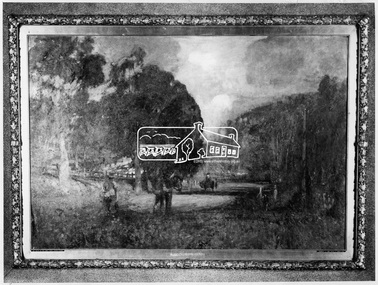
Photograph, Lower Plenty - "The Road to Lower Plenty" - painting by Walter Withers
Source: Geelong Art Gallery via Mr Alan Marshal, then via Shire of Eltham This photo forms part of a collection of photographs gathered by the Shire of Eltham for their centenary project book,"Pioneers and Painters: 100 years of the Shire of Eltham" by Alan Marshall (1971). The collection of over 500 images is held in partnership between Eltham District Historical Society and Yarra Plenty Regional Library (Eltham Library) and is now formally known as the 'The Shire of Eltham Pioneers Photograph Collection.' It is significant in being the first community sourced collection representing the places and people of the Shire's first one hundred years.Digital imagesepp, shire of eltham pioneers photograph collection, montmorency, the road to lower plenty, walter withers -
 Eltham District Historical Society Inc
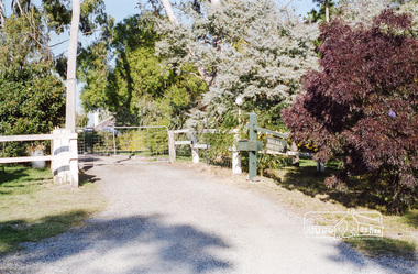
Photograph, Entrance to Rosehill, Bonds Road, Lower Plenty, Autumn Excursion to Lower Plenty area, 18 April 1998, 18/04/1998
Roll of 35mm colour negative film, 2 stripsKodak Gold 200-6activities, bonds road, lower plenty, rosehill -
 Eltham District Historical Society Inc
Photograph - Digital Photograph, Jim Connor, River Bend House, 130 Laughing Waters Road, Eltham, 7 September 2013
Laughing Waters Walk, 7 Sep 2013 This Society excursion was a follow up to the Laughing Waters Story told to us by Jane Woollard at our Annual General Meeting in March 2013. It involved a walk commencing from the corner of Laughing Waters and Overbank Roads along Laughing Waters Road to its eastern end and returning partly over the same route - a total distance of about 2.5km. On the way we visited the two artist in residence properties, River Bend and Birrarung, to view the houses on them that are associated with Alistair Knox, Gordon Ford and others in the local mud brick and artistic community. We also able to walk around the derelict ruin which was once home to Gordon and Sue Ford, Boomerang House. An unexpected afternoon tea was offered to us by the artists in residence at Birrarung House and we had a brief opportunity to view inside the house. River Bend was designed and built by Alistair Knox for Rosemary and Bill Cuming in 1968. It sits in a deep cutting on a steep slope above the Yarra River and features floor to ceiling windows and glass doors set into mission brown timber frames and walls of reclaimed bricks in pinkish hue. Rosemary laid the brick paving around the house, a copy of the shell paving found in the ancient French town of Colmar, where the family had lived for a period. The kitchen was equipped with a 1960s stove as well as a cast iron wood stove reclaimed from Rosemary's sister's home in Armadale. Max and Tini Huygens, migrants from Holland, purchased the property in 1975 and named it Tilwinda from an Aboriginal word meaning 'hole in a rock'. In late 1981 Tini died after a short illness, but Max continued to live at Tilwinda until he moved to a retirement village in 2000 and the property was sold to Parks Victoria. Renamed River Bend, the property became part of the Laughing Waters Artist in Residency Program in 2008. Nillumbik Shire Council upgraded the property in 2012 with solar panels, a heat pump for hot water and double glazing to improve the comfort of the artists in residence and make the house more energy efficient. For a more in-depth description of the property and biographies of the various artists in residence commencing from 2008 to 2015, see Jane Woollard's book, "Laughing Waters Road; Art, Landscape & Memory in Eltham" published 2016.2013-09-07, activities, artists in residence, eltham district historical society, heritage excursion, jim connor collection, laughing waters road, river bend house -
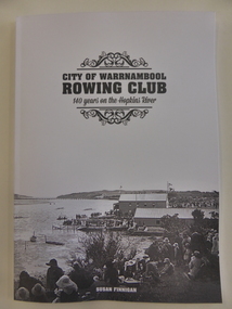 Warrnambool and District Historical Society Inc.
Book, City of Warrnambool Rowing Club, 2016
This book gives the history of the Warrnambool Rowing Club. The club was formed in 1873. In 1885 Mrs Fanny Nelson built a boathouse on the Hopkins River bank and leased it to the Warrnambool Rowing Club. A two-storeyed building for the Rowing Club was opened in 1889 and today the club operates from Proudfoot’s Boathouse near the mouth of the river. This is an important book as it details the history of the Warrnambool Rowing Club. Rowing has been a popular recreational pursuit in Warrnambool since the early days of settlement as the proximity of two rivers makes this possible and the Warrnambool Rowing Club has a history well worth recording. This is a soft-cover book of 85 pages with a white cover with a black and white photograph on the front of the old rowing club sheds on the Hopkins River and several images on the back cover of Warrnambool in the 19th century. The book has eight chapters and has pages with information on life members and committees, a Foreword, a Contents page, an Acknowledgements page, an Index and Endnotes. The book is written by Susan FinneganFront Cover: ‘City of Warrnambool Rowing Club, 140 Years on the Hopkins River’warrnambool rowing club, warrnambool -
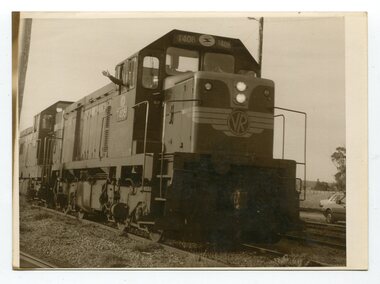 Orbost & District Historical Society
black and white photographs, August 21 1987
These photographs are of the final train to leave Orbost railway Station on August 21 1987 signalling the closure of the line. 3105.12 shows Locomotive T408 and on the side is written "LAST TRAIN EX ORBOST 24.8.87". These photographs are associated with the history of the Orbost-Bairnsdale railway line and therefore reflects the role that the rail line played in the social and economic history of Orbost. The closure of the line was a significant event in Orbost's history.Fifteen black / white photographs of the last train to leave Orbost Railway station.3105.1 - on back - "Last Train leaving Orbost Railway Station on Friday August 21. 1987. SRM August 26 1987 Last train from Orbost, Friday last saw the end of an era when the last freight train to pull out of Orbost Station at about 4.co pm. A symbolic wave from engineer, Bill Buckley, was the only ceremony to mark the passing of rail transport for East Gippsland." 3105.2 - on back - " Last train prepares to leave from Orbost on August 21, 1987." 3105.3 - on back - " The Orbost railhead following the departure of the last train on Friday August 21, 1987. Shows spectators who farewelled the last train." 3105.4 - on back - "From Grandview, Newmerella, shows the last train from Orbost crossing the timber Trestle (sic) viaduct across the Snowy River flats on Friday August 21, 1987" 3105.5 - on back - " A pair of Series 3 "T" Class Diesel Electric locomotives which were used to haul the final train from the Orbost Rail Head on Friday, August 21, 1987. Goods shed on right" 3105.6 - on back - " VFTY Timber Wagons at the Orbost Railway Station. 30 of these large wagons were built for the timber traffic between Orbost and Melbourne. Part of last train to leave Orbost on August 1, 1987." 3105.7 - on back - "The Fordson powered Rail Tractor which was used during shunting at the Orbost railway station, hooked up behind the second locomotive for its final journal from Orbost on Friday August 21, 1987." 3105.8 - on back - "Two Series 3 "T" Class Locomotives (Diesel Electric) were used to haul the final train from Orbost - T408 and T347, T408 was the leading locomotive. Orbost Goods Shed is on the left. Last train left on Friday August 27, 1987." 3105.9 - on back - " 3 "T" Class Diesel Electric locomotives often used in pairs to haul the timber trains out of Orbost. This locomotive was used to lead (haul) the final train from Orbost on Friday August 21, 1987" 3105.10 - on back - "The Gantry at the Orbost Railway Yards - capacity 10 tons. The last wagons before being hooked up to the locos for their last trip out of Orbost on Friday August 21, 1987" 3105.11 - on back - " Station Masters Office and Goods Shed at Orbost Railway Station. The two Series 3 "T" Class Diesel Electric locomotives waiting to haul the final train from Orbost on Friday 21 1987" otrbost-bairnsdale-railway east-gippsland-railway orbosr-railway-closure -
Clunes Museum
Artwork, other - WATER COLOUR
WATER COLOUR OF RIVERGUM TREE PAINTED BY N.H.E.McDONALDLARGE RIVER GUMS IN FOREGROUND. FIVE SHEEP IN SHADE IN RURAL SETTING.RIVER GUMS MURRABIT WEST, VICTORIA. N.H.E. McDONALD local history, illustration, watercolour, mcdonald -
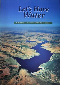 Wodonga & District Historical Society Inc
Book - Let's Have Water - A history of the Fish River Water Supply, Robin McLachlan, Denis Barrett, Jack Domis, Nick Welling, 1997
A history of the development of the management of the Fish River Water Supply Scheme in Central NSW. The scheme extends across the local government areas of the Shire of Oberon, the City of Lithgow and the City of the Blue Mountains.non-fictionA history of the development of the management of the Fish River Water Supply Scheme in Central NSW. The scheme extends across the local government areas of the Shire of Oberon, the City of Lithgow and the City of the Blue Mountains.water nsw, fish river region nsw, oberon dam, water resources development nsw australia