Showing 4555 items matching "the avenue"
-
 Greensborough Historical Society
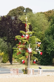
Photograph - Photograph - Digital Image, Marilyn Smith, Christmas in Greensborough 2019, 18/12/2019
Digital images of a decorated Christmas tree on the corner of Nepean Street and Sainsbury Avenue Greensborough, 18/12/2019Part of a collection of miscellaneous historical images with a connection to the local area.Digital colour photographchristmas, nepean street greensborough, sainsbury avenue greensborough -
 Hymettus Cottage & Garden Ballarat
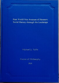
Book - Thesis, First World War Avenues of Honour: Social History Through the Landscape'
non-fictionthesis, great war, ballarat, avenue of honour, michael taffe, war memorials, memory, landscape -
 Canterbury History Group
Ephemera - "Braemar" 15 Wentworth Avenue Canterbury, [2002]
Real estate advertisement for the sale by auction of "Braemar" 15 Wentworth Avenue Canterbury on Saturday 23 November [2002]. Includes a coloured photograph of the exterior of the house and floor and site planscanterbury, wentworth avenue, golden mile, californian bungalows -
Mission to Seafarers Victoria
Letter - Correspondence, 08/12/1950
The writer is replying to a letter from Allan and contains news of fellow seafarers.Quinn CollectionThree page letter written on three sheets of thin, unlined, buff-coloured paper (0853.1a-3a). It is headed Salinas and dated 08/12/50. The air-mail envelope (0853.b) is bordered with red and blue alternating diagonal stripes. It is addressed to Mr Allan Quinn, Liddesdale Avenue, Frankston, Victoria, Australia. The return address, written in the top left hand corner, is Peer Rasmussen, 330 1/2 Central Avenue, Salinas, California, USA. The stamps and part of the post-mark have been torn from the envelope. Letter commences "Hello my friend, ....." and concludes ..."'your sincere friend, Peer."letters-from-abroad, peer rasmussen, salinas -
 Kew Historical Society Inc
Plan - Subdivision Plan, J R Mathers & McMillan, Glenferrie Road, Cotham Road, Belmont Avenue, Stirling Street, 1910-1930
Pru Sanderson, in her groundbreaking ‘City of Kew Urban Conservation Study : Volume 2 - Development History’ (1988), summarised the periods of urban development and subdivisions of land in Kew. The periods that she identified included 1845-1880, 1880-1893, 1893-1921, 1921-1933, 1933-1943, and Post-War Development. These periods were selected as they represented periods of rapid growth or decline in urban development. An obvious starting point for Sanderson’s groupings involved population growth and the associated economic cycles. These cycles also highlighted urban expansion onto land that was predominantly rural, although in other cases it represented the decline and breakup of large estates. A number of the plans in the Kew Historical Society’s collection can also be found in other collections, such as those of the State Library of Victoria and the Boroondara Library Service. A number are however unique to the collection.The Kew Historical Society collection includes almost 100 subdivision plans pertaining to suburbs of the City of Melbourne. Most of these are of Kew, Kew East or Studley Park, although a smaller number are plans of Camberwell, Deepdene, Balwyn and Hawthorn. It is believed that the majority of the plans were gifted to the Society by persons connected with the real estate firm - J. R. Mathers and McMillan, 136 Cotham Road, Kew. The Plans in the collection are rarely in pristine form, being working plans on which the agent would write notes and record lots sold and the prices of these. The subdivision plans are historically significant examples of the growth of urban Melbourne from the beginning of the 20th Century up until the 1980s. A number of the plans are double-sided and often include a photograph on the reverse. A number of the latter are by noted photographers such as J.E. Barnes.A ‘proposed’ subdivision of the area in the vicinity of Cotham and Glenferrie Roads and Belmont Avenue depicts an alternate vision for how the land might be divided into lots. When comparing this undated proposed subdivision with a modern map, it is possible to see why the subdivision did not eventuate. The right-of-way shown in the plan as beginning in Belmont Avenue was to be extended much further, preventing the lower lots from being created in the proposed shapes. Identifying the date of the name change may assist in the dating of the proposed subdivision. In faded writing at the top of the plan is an annotation referring to ‘Abbotsford’ and Finlayson’s Agency.subdivision plans - kew, glenferrie road, cotham road, belmont avenue, stirling street -
 Federation University Historical Collection
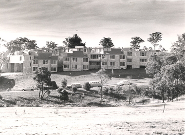
Photograph - Black and White Photographs, Views of Mount Helen Campus, c1973
Ongoing photgraphic record of Mount Helen Campus development. A contract for the construction of Student housing, Union building (later Albert Coates Complex), and a four storey library (later E.J.. Barker Library) on the Mt Helen campus was signed in November and December 1971. They were all completed and occupied in 1973. Views of Mount Helen Campus .1) Signposts of first turnoff campus road from Gear Avenue .2) Mount Helen Student Residences (stage 1) .3) Rear view of Mount Helen Student Residences (Stage 1)mount helen campus, buildings, student residences -
 Federation University Historical Collection
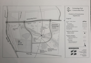
Map, Matthew Cibson, University of Ballarat Centre for Environmental Management, Ballarat Technology Park Conservation Plan, 1997, 02/1997
The Ballarat Technology Park is on the Federation University Mount Helen CampusMap showing the Ballarat Technlogy Camp, Greenhill Enterprise Centre, Canadian Wetlands. hand-made brick culvert sleepers, Ballarat-Buninyong Railway Line, IBM Global Services, early wooden bridge, Canadian Creek, Gear Avenue. ballarat technology park, canadian wetlands, greenhill enterprise centre, brick cultert, railway, ballarat-buninyong railway -
 Phillip Island and District Historical Society Inc.
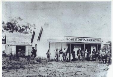
Photograph, c 1900
Original photograph was copied and enlarged for museum display.Black & White enlargement of a photograph of the J & S West Cowes General Store in Thompson Avenue Cowes. People standing on verandah in front of the store. Bullock team right front of picture. The original photograph is catalogue/registration no. 154-10.j & s west general store cowes phillip island, cowes general store phillip island -
 Hume City Civic Collection
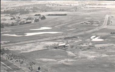
Photograph
A black and white aerial photograph of an aerial view of the newly established Goonawarra Golf Club. Sunbury Road is visible in the bottom LH corner and Francis Avenue crosses the photograph. The clubhouse is in the centre of the photograph and some early housing development is in the distance.goonawarra gold club, housing developments, regional newspaper, george evans collection -
 Whitehorse Historical Society Inc.
Document, The Poultry farm at Mitcham, 1/09/1996 12:00:00 AM
Part of an autobiography of Charles OvermanPart of an autobiography of Charles Overman who owned a poultry farm in Vernal avenue, Mitcham from 1928 to 1949. It includes his social activity, chiefly among Catholic friends and his experiences in the industry. 9 pages. Photocopy of typescript.Part of an autobiography of Charles Overman overman, charles;, poultry, vernal avenue, mitcham -
Kew Historical Society Inc
Archive (Sub-series) - Subject File, Kew Historical Society et al, JONES, Robert & Family, 1958
Various partiesReference, Research, InformationSecondary Values (KHS Imposed Order)Subject file containing a typed letter by David Jones, including reference to his forebears who lived in Woodford Avenue, then 152 Bulleen Road (1888-92) Kew. Thomas Jones had a tailor shop at 4 Cotham Road.kew - history, 4 cotham road - kew (vic), retailers - kew (vic), 152 bulleen road - kew (vic)kew - history, 4 cotham road - kew (vic), retailers - kew (vic), 152 bulleen road - kew (vic) -
 Kew Historical Society Inc
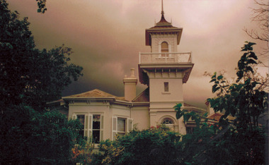
Photograph - 'Swinton', 23 Swinton Avenue, 2000
Swinton is of significance as one of the earliest examples of the use of the Italianate in Australian domestic architecture, and for the elegance of its design, particularly in the tower.Original colour positive photograph of the west elevation of Swinton, 23 Swinton Avenue, Kew. Facade facing Yarra River featuring tower and balcony with door and fanlight below. Projecting bay window at left. Rendered brick with slate roof. Ink on reverse: "Swinton - west elevation / Feb 2000"swinton, swinton avenue -- kew (vic.) -
 Kew Historical Society Inc
Drawing - Property Illustration, Margaret Picken, 30 Florence Avenue, Kew, 1996
This architectural drawing is one of a series created by Margaret Picken for a number of real estate agents in Melbourne between 1983 and 2005. Each work is signed and dated by the artist.Gift of Margaret Picken, 2020Extant (in 2020) rendered neo-Georgian house, built in 1990. Renovations in 2004 included alterations to the facade. The pen and ink architectural drawing on drafting film of 30 Florence Avenue, made by Margaret Picken in 1996, predates the alterations to the facade.30 FLORENCE AVE., KEW / MARGARET PICKEN '96 / WOODARDS ~ HAWTHORNartist -- margaret picken 1950-, architectural drawings -- houses -- kew (vic.), 30 florence avenue - kew (vic). -
Canterbury History Group
Ephemera - 5 Monomeath Avenue Canterbury, [2004]
Real estate advertisement for the sale by auction of "Langley" 5 Monomeath Avenue Canterbury c1936 on Saturday 15 May {2004].Includes coloured photographs of the interior and exterior of the house and floor and site plans. Includes a covering letter from the agents.canterbury, monomeath avenue, langley, mcilwraith family, golden mile, stairs, swimming pools, tennis courts -
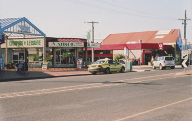 Lakes Entrance Historical Society
Photograph - Post Office and Centre Point Arcade Lakes Entrance Victoria c2006, M Holding, 2006
Colour photograph showing the corner of Esplanade and Barkes Avenue with the Post Office on the Eastern corner and Centre Point Arcade on the Western corner taken when the main arcade shop was occupied by camping and Leisure business Lakes Entrance Victoria c2006 accommodation, postal services, roads and streets, businesses -
 Ringwood and District Historical Society
Photographs, 1979-80 MMBW pipe line project at Hubbard Reserve, North Ringwood � Sewer tunnel
Part of a 43-photo record of the MMBW�s engineering feat in drilling a 12 inch pipe line up to 40 feet deep through rock hardened by volcanic action associated with geological fault that occurs along the line. The work took place from October 1979 to May 1980 on the southern boundary of Hubbard Reserve, North Ringwood. The collection was presented to the Ringwood Historical Research Group by J Clarke on 9th June 1980.E561 N7 Feb 1980 A43 Work on sewer tunnel below Burlock Avenue. Line of shafts running from manhole in gully to the consecutive groups on top left. -
 Ringwood and District Historical Society
Photographs, 1979-80 MMBW pipe line project at Hubbard Reserve, North Ringwood � The new trach goes on down to Debbie Place
Part of a 43-photo record of the MMBW�s engineering feat in drilling a 12 inch pipe line up to 40 feet deep through rock hardened by volcanic action associated with geological fault that occurs along the line. The work took place from October 1979 to May 1980 on the southern boundary of Hubbard Reserve, North Ringwood. The collection was presented to the Ringwood Historical Research Group by J Clarke on 9th June 1980.E566 N13 13 May 1980 A43 The parting of the ways. My old track goes left to Burlock Avenue. The new way goes on down to Debbie Place. -
 Ringwood and District Historical Society
Photograph, Herman Pump's orchard and home Heathmont - 1923 - in vicinity of Royal Avenue. House on Canterbury Road, later site of Uniting Church
Black and white photograph of orchard. House in top left of photograph.Typed on backing sheet below photograph, "Herman Pump's orchard and home Heathmont - 1923 - in vicinity of Royal Avenue. House on Canterbury Road, now site of Uniting Church". -
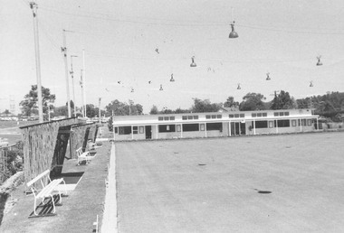 Ringwood and District Historical Society
Photograph, Ringwood Bowling Club- New clubrooms, 1972
Black and white photograph"Written on back of photograph" Bowling green and new clubrooms. 22.11.72. Miles Avenue site. Clubrooms were built in 1968 after the old clubrooms were destroyed by fire. -
 Ringwood and District Historical Society
Document, Ringwood Bowls Club- Letterhead, City of Ringwood Bowls Club Inc., 1984
Copy of Letterhead.City of Ringwood Bowls Club Inc. Miles Avenue, Ringwood, Vic., 3134. P.O. Box 149, Ringwood, 3134. Telephone: 870 6767. 14th March, 1984. -
University of Melbourne, Burnley Campus Archives
Newspaper - Newspaper Cutting, 54
An Avenue of Trees is being planted at Mooroolbark railway station in memory of the Late Dame Nellie Melba. The originator of the scheme, Miss Edna Walling, is shown planting the first tree.avenue, tree, mooroolbark, railway station, dame nellie melba, edna walling, planting -
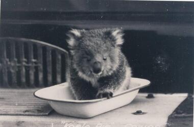 Phillip Island and District Historical Society Inc.
Photographs, Kodak, Early 20th Century to mid 20th Century
A collection of a group of photographs donated to the Society by Lun Blom, from the Photo Shop in Thompson Avenue, Cowes (was opposite the museum)A collection of 19 photographs of Phillip Island and surrounds. 293-01. Koala sitting in enamel bowl on table 293-02. 20 farmers having a break. 293-03. Reproduction of painting of The Nobbies. 293-04. Photograph of a Trophy for 1st prize for ploughing won by Mr L Morrison 1859. 293-05. Photograph of three men standing in front of a motor vehicle. 293-06. Photograph of view of Cleeland's House at Cape Woolamai. 293-07. Photograph of a whale beached on Phillip Island with people standing around it. 293-08. Photograph of a family and children in front of car - unknown. 293-09. Photograph of a painting of "Innishowen" Harbison's Property. Mr Harbison's portrait inset on the painting. 293-10. Photograph of an early map - possibly drawn by Bass & Flinders. 293-11. Photograph of the San Remo-Westernport Hotel, with vehicles in front. 293-12. Photograph of a fishing boat at the San Remo Jetty with the township in the background. 293-13. Photograph of a couta boat under full sail in Westernport. 293-14. Photograph of an aerial view of the Two Bridges taken from San Remo side. 293-15. Photograph of the Mutton Bird Eggers Camp - Bergins Bay Cape Woolamai. 293-16. Photograph of a Steam ferry decorated with flags. 293-17. Photograph of Fisherman's hut at Cowes with pier in the background. Possibly Mr Cox's. 293-18. Photograph of a couple standing on the bridge in Lover's Walk Cowes. 293-19. Photograph of an aerial view of Phillip Island looking towards Mornington Peninsula and the Heads to Port Phillip Bay in the distance.293-01. "Koala Pie" Cowes. 293-06. Mr Cleeland's Station. 293-09. "Innishowen" Mr. Harbison. 293-10. Phillip Island. 293-17. Phillip Island - Fisherman's Hut, Cowes. 293-18. Phillip Island - Lover's Walk, Cowes.wildlife - koala, wildlife - whale, the nobbies, ploughing trophy, cape woolamai - cleeland's house, innishowen, mr harbison, phillip island map, westernport hotel san remo, fishing boat san remo pier, couta boat westernport, the two bridges san remo, mutton bird eggers camp, steam ferry, fisherman's hut cowes, lover's walk cowes, aerial view of phillip island, lyn blom -
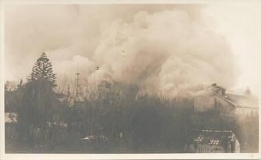 Phillip Island and District Historical Society Inc.
Photograph, 23/04/1925
Two photographs taken by Jessie "Girlie" Smith of San Remo who owned the Penguin Cafe in Thompson Avenue, CowesPhotograph (2) of scene during fire at Isle of Wight Hotel. Most of the buildings obscured by smoke. Small hut front right.Post Card for both "Isle of Wight fire - it made a clean sweep in less than an hour. A new up to date three story Hotel is to be commenced next week." on one of the photos.phillip island, isle of wight hotel fire, jessie smith -
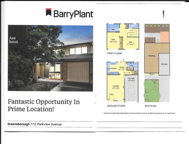 Greensborough Historical Society
Advertising leaflet, Barry Plant Greensborough, 7/12 Parkview Avenue Greensborough, 2019
Auction of 2 storey townhouse, 7/12 Parkview Avenue Greensborough, held 6 July 2019, sold for $465,0002 p. auction leaflet, printed in colour both sides, folded twiceparkview avenue greensborough -
 Greensborough Historical Society
Advertising leaflet, Barry Plant Greensborough, 64 Sainsbury Avenue Greensborough, 2019
Sale leaflet for 3 bedroom single storey house, 64 Sainsbury Avenue Greensborough, sold June 2019 for $725,0002 p. cardboard leaflet, printed both sides, folded twicesainsbury avenue greensborough -
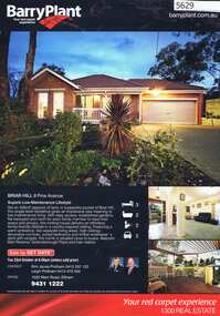 Greensborough Historical Society
Advertising Leaflet, 9 Pine Avenue Briar Hill, 07/11/2012
9 Pine Avenue Briar Hill. 3 bedroom home, private sale, sold 7 November 2012 for $515,000Real estate advertising leaflet, 1 sheet, printed in colour both sidespine avenue briar hill -
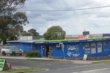 Greensborough Historical Society
Photograph - Photograph - Digital Image, Marilyn Smith, Aussie Angler Greensborough 2019, 19/09/2019
Digital images of Aussie Angler Greensborough, Corner Sherbourne Road and Graeme Avenue Briar Hill 19/09/2019Part of a collection of miscellaneous historical images with a connection to the local area.Digital colour photographsfishing, aussie angler, angling -
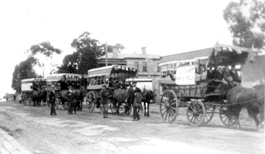 Surrey Hills Historical Society Collection
Photograph, Preparing to leave for the St George's Church of England Sunday School picnic, Mont Albert Road, 1922, 1922
The drags would have been leaving St George's Church of England in Mont Albert Road. The foundation stone for St George's Church of England, Mont Albert was laid in 1886 on land donated by Edward Dyer and the first service was preached in January 1887. From 1904 until 1907 it was known as Holy Trinity, Surrey Hills. The original church was weatherboard and replaced by a brick one in the Gothic Revival style which was designed by local architect George J V Blackburne, who also designed the Wesleyan School at Surrey Hills. The building was partly funded by donations, profits from a bazaar and concert, and other people donated furnishings. The church had boundaries along Mont Albert Road and St Georges Road. In 1998 the Church was sold and converted into a complex of units. Its current address is 19 St Georges Avenue, Mont Albert. The annual Sunday School picnic was held at Hampton and drags were the usual mode of transport. 'Lugano' was built in 1893 for William Wilson, a prominent stonemason and importer of marble fireplaces. In 1903 it became the home of William Holmes who was Chief Electrical Engineer for the Victorian Railways. He designed the electrification of the Melbourne suburban network. 'Lugano' stayed in the Holmes family until the 1930s. The annual Sunday School picnic was held at at a variety of locations and drags were the usual mode of transport. Donor information is that this was taken as the congregation prepared to depart for at Hampton on the picnic held on 25/2/1922. There are 2 copies: the original donated print and an enlargement. The original was mounted on card with photo mounts along with 506, 871, 872, and 873. It measures 13 cm x 9 cm.Black and white photo of 4 'drags' (horse-drawn hooded carriages) lined up in Mont Albert Road near the corner of St George's Avenue, in readiness for departure for the Sunday School picnic. The carriages are loaded with people and decorated with flags. The front carriage has a material sign attached to the side; the top line of writing is not decipherable, but the bottom one reads "SURREY HILLS". Four men stand in the road, which has bluestone curb and channelling. In the background is 'Lugano'.On rear in ink: "S.S. picnic to Hampton / 25th. Feb. 1922" and in a different hand in biro: "At Mont Albert. St George's Church"churches, holy trinity church, anglican church, sunday schools, picnics, lugano, horse-drawn vehicles, william wilson, willaim holmes, st george's church of england, mont albert, mont albert road -
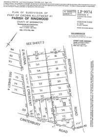 Ringwood and District Historical Society
Document - Subdivision Plan, LP9974 Part of Crown Allotment 41, Parish of Ringwood, County of Mornington Vol 1773 Fol 464 - 1924
LANDATA Land Victoria 4-sheet plan printout dated 2009Sheet 1 includes Alvena Crescent, Bedford Road and Canterbury Road, Heathmont. Additional markings include RP16869. Sheet 2 includes Alvena Crescent and Bedford Road, Heathmont. Additional markings include PS318390 and CP161633. Sheet 3 includes Bedford Road, Alvena Crescent and Royal Avenue, Heathmont. Additional markings include RP454. Street name amended from Leonard Street to Royal Avenue Vide Gaz 1962 P.427. Sheet 4 includes Alvena Crescent, Royal Avenue, Coleman Street and Canterbury Road, Heathmont. Additional markings include SP27861, PS305057, RP10566, SP34722 and LP116573. -
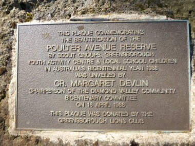 Greensborough Historical Society
Photograph - Digital image, Plaque - Poulter Avenue Reserve Greensborough, 18/04/1988
Photograph of Plaque located in Greensborough's Poulter Avenue Reserve. The inscription reads: "This plaque commemorating the beautification of the Poulter Avenue Reserve by scout groups, Greensborough Youth Activity Centre & local school children in Australia's Bicentennial year 1988 was unveiled by Cr. Margaret Devlin chairperson of the Diamond Valley Community Bicentenary Committee on 18 April 1988. This plaque was donated by the Greensborough Lions Club" Digital copy of colour photograph.poulter avenue reserve greensborough