Showing 32358 items matching "building"
-
 Greensborough Historical Society
Photograph - Digital image, Jasmin Burge, Loyola: foundation stone 2012, 27/11/1932
Loyola Foundation stone (photographed in 2012). Latin inscription. Foundation stone for seminary laid in 1932. Part of a collection of photographs of Loyola College, The College was officially blessed and opened on 16/12/1934 with 8,000 people present. Grimshaw Street Watsonia, established 1980 on the site of the Loyola Seminary. The College purchased the original building in 2002. These photographs of the original building and grounds were taken by GHS member Jazz Burge in June 2012.Digital copy of colour photograph.loyola seminary watsonia, loyola college -
 Kiewa Valley Historical Society
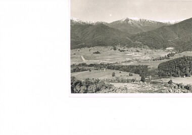
Photograph Transmission lines Mount Beauty, 66 KVA Transmission lines from Clover Power Station, Circa 1950
This photograph is a "snap shot" in time circa 1950s detailing the rural environmental change and the progressive effects of the Kiewa Valley Hydro Scheme on the basic rural setting of the valley (note the sparsity of rural infrastructure). This photograph shows the beginning of the accommodation and administration buildings for use by the construction workers and auxiliary administration employees of the Victorian State Electricity Commission. It also provides a view of the landscape before extensive development of Pondage and other non rural buildings.This photograph details a dramatic period in time which saw an enormous change to the exclusively rural area of the Kiewa Valley region in the mid 1900s (see sparse rural buildings/houses). This change presented both physical and mental challenges to the existing quiet rural inhabitants of the valley. The State of Victoria had to make adjustments to the changing demands imposed by population and industrial expansions. The development of cleaner energy supplies to a growing population has its downside ,which ever way the intrusion into the "natural" landscape is made. The construction of the large Pondage at the centre of the photograph is a good example.This black and white photograph of a panoramic view of the Kiewa Valley (Mount Beauty SEC construction workers village) shows the newly completed transmission line towers delivering electrical power(66KVA) from the Clover Power Station. The photo is on 200gms paper and not on special photographic paper.mount beauty 1940 to 1950s, development of sec kiewa hydro scheme, sec victoria -
 Warrnambool and District Historical Society Inc.
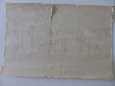
Document, Drawing of church of Christ Warrnambool, Mid 20th century
These are plans for proposed additions to the Church of Christ in Warrnambool. The date of the drawings and the maker of the plans are unknown. The additions do not appear to have been built. The Church of Christ in Warrnambool was founded in 1875 after a meeting at the Warrnambool Temperance Hall. The building in Spence Street Warrnambool was erected in 1884 at a cost of £1600 and officially opened in 1885. This church was sold and in 2000 the congregation moved to a new building at 186 Raglan Parade (called Gateway Church of Christ).These plans are of some interest as being part of the history of a Warrnambool church – the Church of Christ Warrnambool. These are two rough drawings on cream-coloured paper showing proposed additions to the Church of Christ in Warrnambool. The drawings are in pencil and include the front elevation plan and the first floor plan. The captions are in capital letters. Both pages have tattered edges and are torn across the middle and the pages are stained in places.‘Rough drawing suggested additions for Church of Christ Warrnambool’ ‘Suggested additions for Church of Christ Warrnambool’ church of christ warrnambool, gateway church of christ, history of warrnambool -
 Federation University Historical Collection
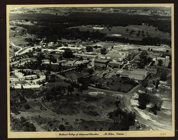
Photograph - Photograph - Black and White, Ballarat College of Advanced Education, Mt Helen - 1985, 1985
Photograph of the early years of the Ballarat College of Advanced Education at Mt Helen. On the left is the first stage of the student accommodation with a bridge connecting it to the campus. The car park located near the lakes is next to the Physical Education building. This is before the swimming pool has been added. The building with large white external structure is the E.J.Barker Library before the top floor has been built. This floor is where the Geoffrey Blainey Research Centre is housed.Photograph mounted on heavy white card which is then mounted onto black board. Aerial photograph of Ballarat College of Advanced Education at Mt Helen.ballarat college of advanced education, student accomodation, physical education, swimming pool, e j barker library, geoffrey blainey research centre, student residences -
 Tatura Irrigation & Wartime Camps Museum
Photograph, Camp 13 Hospital, 1956
Photos taken by Col McTaggart engaged in the removal of the original Camp 13 hospital building after the occupation of the camp by the State Rivers & Water Supply Commission Construction Branch c.1956. The building, bought by Mr. Henry, was transported to Corop in three sections, the high central section now a private residence located on the cnr. Midland Highway and Lake Cooper Road, the two outer sections converted to a house in Lake Cooper Road.Black & White, two A4 sized photos of Camp Hospital.tatura, camp 13 hospital, german pows, corop, photography, photograph, slides, film -
 Mt Dandenong & District Historical Society Inc.
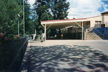
Photograph, Mount Dandenong Primary School 1997, 1997
The first Mt Dandenong State School opened in a shed on the property of William Ferguson on the corner of Blythe and Old Coach Roads. The first teacher was Miss Ethel Gruber who opened the school on May 11th, 1897. It wasn’t until 1901 that the school shifted over the road into an old school building that was moved up to the new site from Ringwood. All the buildings were demolished to make way for a new school that opened in 1991. Looking across from asphalted area to the 'undercover area' November 1997.mount dandenong, mt dandenong school -
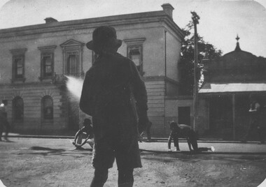
 Ballarat Tramway Museum
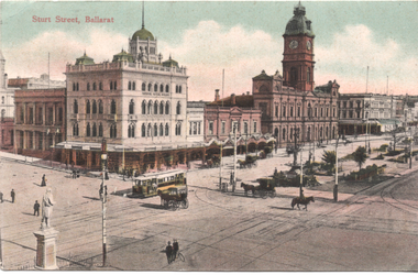
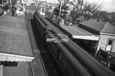
Postcard, WTP, "Sturt Street Ballarat", c1907
The photo, by WTP of Ballarat, is of the corner of Sturt and Lydiard St from a postcard, 1908. Take from the Post office building looking towards the National Mutual Life building, and the Town Hall. There are numerous horse-drawn vehicles in the image along with an ESCo tram. See item 4774 for a black-and-white digital image of this card. The card has been used in a letter to a Mrs. D Low of Hillingworth near Newcastle from an Annie Gibson.Yields information about the corner of Sturt and Lydiard St in 1907c,Postcard coloured, divided back with a handwritten letter on rear. Postmarked 2-9-1908See image 2 for details of the handwritten note on the rear. tramways, trams, sturt st, postcards, lydiard st -
 Sunbury Family History and Heritage Society Inc.
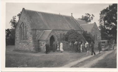
Photograph, c 1930s
St. Mary's Anglican Church at Bulla originally occupied a site along Oaklands Road, adjacent to 'Woodlands' homestead. It was established in 1859. With there building of the Melbourne Airport at Tullamarine it was found that the church on its existing site was directly under the flight path of the aircraft so the building was demolished stone by stone and rebuilt in the Bulla township adjacent to the Alistair Clark Rose Garden. The original site has not been developed because some early graves are there.St. Mary's Church at Bulla is one of the earliest to be established in the Bulla district. Its mother church, St Pauls Church of England at the original Broadmeadows township was established in 1850 and it still stands and operates on its original site.A black and white photograph with a cream border of a stone church with the congregation members entering the church. A saloon car is parked near the church.st. mary's church of england, bulla., churches. -
 Vision Australia
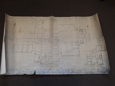
Plan - Image, RAAF HQ Royal Victorian Institute for the Blind, 14/3/1942
In 1942, the expansion of the war into the Pacific expanded wartime operations in Australia and some of the RVIB buildings were comandeered for house military staff. This plan, drawn up in March 1942 by J.G. and authorised by the Superintending Architect and (W. Dale)Works Director Air Services show the layout of the main building at 557 St Kilda Road as well as that of the babies nursery. Doorways, cupboards and stairwells are annotated in this carbon copy, as well as the layout of Ormond Hall.1 architectural plan of St Kilda Road layoutmyer house, royal victorian institute for the blind, plans, raaf -
 Melbourne Tram Museum
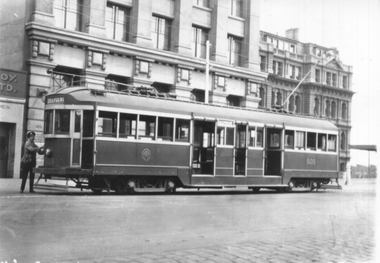
Photograph - Tram 509 Collins and Spencer Sts, late 1920s
Photograph shows W2 class tram No. 509 at the Collins St terminus at Spencer St. The driver is attending to the trolley pole rope. The tram has the destination of Deepdene and is yet to be fitted with route number boxes. The tram was built as a W2 entering service 13/6/1928 and was fitted with route number boxes in March 1930. In the background is the State Savings Bank building, now the Batman Hill Hotel and part of the VR Head Office building.Yields information about tram 509 and the Collins St terminus late 1920s.Black and white print with photographers notes on the rear.In pencil "W2 class at City terminus Cnr Collins & Spencer Sts."trams, tramways, w2 class, collins st, tram 509 -
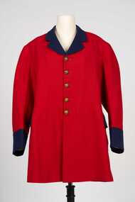 City of Greater Bendigo - Civic Collection
Uniform - Postal Workers Uniform, c. 1890
The post office was situated on site at this Pall Mall location from 1887 until 1997. Early on the building housed a variety of government services included sub treasury, police, water, lands, post and telegraph and quarters for the resident postmaster. With federation in 1901 the building became the Commonwealth Postmaster - General's Department's Bendigo Post Office. In 1975 postal services were taken over by the Australian Postal Commission and in 1989 Australia Post was corporatised.Colonial era postal uniform possibly worn by the Post Master at the Bendigo Post Office. Single breasted frock coat. Scarlet jacket with contrasting royal blue collar, lapel cuffs and pocket flap. Body and skirt section lined with lighter red cotton fabric, pockets lined with cream coloured cotton fabric, sleeves lined with brown, blue and white striped cotton fabric. Five brass buttons on front, two brass buttons on the top of the centre back pleat, each button with a crown and VR. Typically of frock coats of the 19th century the coat has a two distinct sections, a top jacket and skirt. The shoulder seam is bias cut and runs at an angle down the back. The back is cut in four sections and the skirt in two sections. There are no side seams in the coat, instead there is a seam placed further back than the actual side of the wearer.Any possible text on the label on inner top of collar has disappeared.australia post, city of bendigo post office, city of greater bendigo commerce -
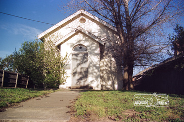 Eltham District Historical Society Inc
Photograph, Doug Orford, Eltham Courthouse, 730 Main Road, Eltham, 1985, 1985
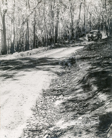
This building is a fine example of a very early small brick country court house which retains its furnishings and has important associations with the early history of the Eltham township. It was used for Eltham Road Board meetings in the 1860s and later to provide additional school accommodation. It is the oldest public building remaining in Eltham and forms an important group in historic and streetscape terms with the adjoining former police residence. The survival of the furnishings (of unknown origins) is of particular significance given the building's age. This building, and the former police residence beside it, were constructed as a result of a petition by five Eltham residents in 1857. The nearest police were at Heidelberg eight miles away or at the Caledonia Diggings 21 miles away. After the construction of the Court of Petty Sessions at Eltham in 1859-60 (which was designed by the Public Works Department and built by a Mr Duncan for a cost of 536 pounds), it was used for a variety of purposes. Eltham Road Board meetings were held there until 1868 when the board was transferred to Kangaroo Ground and as the Road Board Secretary's office, until this was transferred to Wingrove Cottage in 1867. It was used as an overflow for the Dalton Street School in 1875. According to National Trust records, the Eltham Court House is a relatively rare building type. There are only six other known examples of similar small brick country court houses in the state which have small projecting entry porches and a gabled form. Roll of 35mm colour negative film, 7 stripsFuji 100Neltham, eltham courthouse, main road -
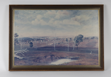 Bacchus Marsh & District Historical Society
Painting, View of Bacchus Marsh from Stamford Hill circa 1880s
The date of the scene depicted in this painting has not been identified. The painting has no artist signature or date. The view depicted is from an area close to the present day Madden Drive in Bacchus Marsh. The angle of the view suggests the artists viewpoint may have been from a spot close to the intersection of Madden Drive and Muir Street looking east over the town. Several buildings constructed in the 1860s and 1870s can be seen in the painting. These include Saint Andrews Presbyterian Church (now Uniting Church), built 1865, Stone Villa in Bennett Street, the Bacchus Marsh Court House, the former National Bank and the Border Inn, all on Main Street, and in the distance Saint Bernard’s Catholic Church. Buildings such as Simon’s Garage erected in 1913, on the corner of Main Street and Grant Street are not shown. In the foreground running horizontally Grant Street can be seen. The view of Grant Street shows very few buildings. One house in the centre of the picture is Murdoch's Cottage. A brick house constructed in 1868 on the corner of Grant Street and Waddell Street. To the right of the picture along Grant Street no buildings are shown. The store built by John Jory in 1890 at 60-62 Grant Street which survives as a building in 2025 is not shown. Some allowance for artistic interpretation must be allowed but based on what the scene depicts it suggests a scene of Bacchus Marsh in the late 1870s or 1880s. Print reproduction of an oil painting. Framed. Undated. Unsigned. BMDHS Location: AR/B12/Beside (on floor)views bacchus marsh vic., paintings bacchus marsh vic., landscapes bacchus marsh vic. -
 The Beechworth Burke Museum
Photograph, Circa 1900
Taken in Beechworth, this photograph depicts a two storey granite stone building and five figures in the background conducting a fire drill as a young boy in the foreground watches on. Black and white rectangular photograph. Image is printed on gloss photographic paper and has a white unprinted border area. Obverse: BANK OF VICTORIA Reverse: 4600 (in pencil) beechworth, bank of victoria, bank of victoria, beechworth, granite, fire drill -
 Eltham District Historical Society Inc
Photograph, George Coop, Surrey Hills Railway Station, c.1951
The photo possibly taken in a hurry (given the misalignment of aim, lack of focus and motion blur) is still significant as it records the style and placement of buildings and advertsing of the day.Digital TIFF file Scan of Kopdak 620 black and white negative transparencygeorge coop collection, red rattler, surrey hills railway station, tait train -
 Marysville & District Historical Society
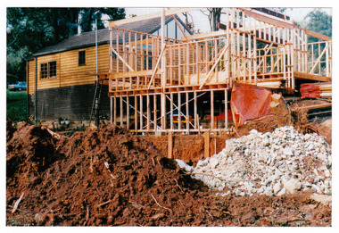
Photograph (Item) - Colour photograph, Unknown
A colour photograph taken during the construction of Arbor Green Cottage in Marysville. This cottage, along with most of the buildings in the township, was destroyed in the 2009 Black Saturday bushfires.A colour photograph taken during the construction of Arbor Green Cottage in Marysville.1 Falls Rd M'sville./ The future ahead./ The Arbor Green Galleries/ 3 Levels.marysville, victoria, australia, photograph, accommodation, arbor green cottage, 2009 black saturday bushfires -
 Marysville & District Historical Society
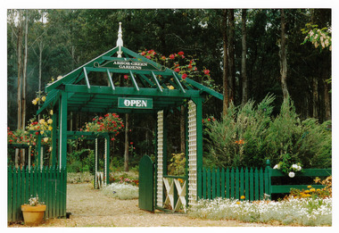
Photograph (Item) - Colour photograph, 1992
A colour photograph of the garden entrance and bridge at Arbor Green Gardens in Marysville. This cottage, along with most of the buildings in the township, was destroyed in the 2009 Black Saturday bushfires.A colour photograph of the garden entrance and bridge at Arbor Green Gardens in Marysville.Garden Entrance & bridge./ Arbor Green Galleries/ 1 Falls Rd. M'sville./ Spring 1992marysville, victoria, australia, photograph, accommodation, arbor green cottage, 2009 black saturday bushfires -
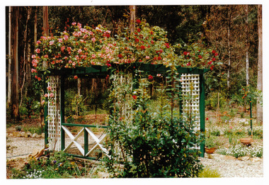
 Marysville & District Historical Society
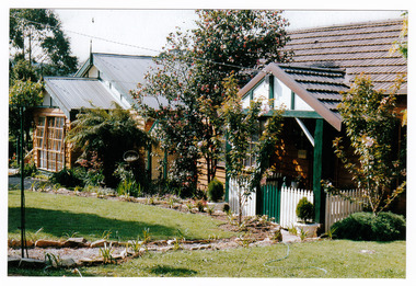
Photograph (Item) - Colour photograph, Unknown
A colour photograph of the front facade and garden of Arbor Green Galleries in Marysville. This cottage, along with most of the buildings in the township, was destroyed in the 2009 Black Saturday bushfires.A colour photograph of the front facade and garden of Arbor Green Galleries in Marysville.1 Falls Rd M'sville./ Arbor Green Galleries & Cottage.marysville, victoria, australia, photograph, accommodation, arbor green cottage, 2009 black saturday bushfires -
 Marysville & District Historical Society
Photograph (Item) - Colour photograph, 1992
A colour photograph of the front pergola at the entrance to Arbor Green Galleries in Marysville. This cottage, along with most of the buildings in the township, was destroyed in the 2009 Black Saturday bushfires.A colour photograph of the front pergola at the entrance to Arbor Green Galleries in Marysville.1 Falls Rd M'sville./ Arbor Green Galleries & Cottage.marysville, victoria, australia, photograph, accommodation, arbor green cottage, 2009 black saturday bushfires -
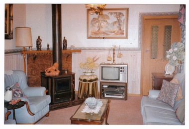 Marysville & District Historical Society
Photograph (Item) - Colour photograph, Unknown
A colour photograph of the sitting room in the cottage at Arbor Green Galleries and Cottage. This cottage, along with most of the buildings in the township, was destroyed in the 2009 Black Saturday bushfires.A colour photograph of the sitting room in the cottage at Arbor Green Galleries and Cottage.1 Falls Rd. M'sville./ Cottage Sitting Room.marysville, victoria, australia, photograph, accommodation, arbor green cottage, 2009 black saturday bushfires -
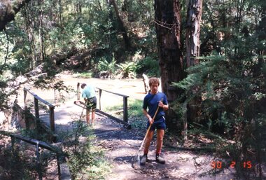 Greensborough Historical Society
Photograph - Photographs, Carolyn Haas, Janefield Special School: Lyrebird Track clearing 15/02/1990, 15/02/1990
5 photographs of a Thursday task - clearing the Lyrebird Track. Janefield Special School helped with building and maintaining of this wheelchair friendly track at Kinglake National Park.4 colour photographs. janefield, janefield special school, kinglake national park -
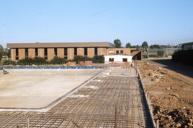 Greensborough Historical Society
Photograph - Digital Image, Watsonia High School Pool, Construction 1976. Concretee pool and surrounds under construction 1, 12/12/1976
The swimming pool at Watsonia High School was commenced in 1976 and opened in 1977. This photo shows the concrete pool and surrounds under construction with Library building in background..While the school has gone, the pool remains in 2019, operating as Yarra Swim School, Liat Way GreensboroughDigital copy of colour photograph, scanned from slide. Slide set at Item 6513.watsonia high school, swimming pools greensborough, yarra swim school -
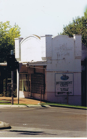
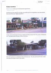 Greensborough Historical Society
Article and Photograph, Purdy's furniture, 2017_
Photographs and captions relating to the Purdy's Furniture business in Sherbourne Road Briar Hill, previously Briar Hill Timber. These buildings have now been demolished.This text and photographs were copied from a Facebook site. Members are people who lived in the Greensborough area and share their reminiscences of the area with others. The site is administered by a GHS member but is not officially affiliated with the Society. Any information is the opinion of the contributor. Photographs and text sourced from social media.purdys furniture briar hill, briar hill timber and hardware, sherbourne road briar hill -
 Greensborough Historical Society
Nail Spacer, House gutter nail spacer, 1970-1980
This spacer was used when installing guttering on houses. Similar spacers were used by Gary Partington when building houses in the mid to late 20th Century.Metal nail and spacer.gary partington, guttering, gutter spacers -
 Greensborough Historical Society
Photograph - Digital image, Frank Solomon, Small shop corner Grimshaw and Main Streets Greensborough, 04/06/2010
Small shop corner Grimshaw and Howard Streets Greensborough. Now demolished. This building was the former office of John Cecil Jessop, known locally as 'Jessop's Corner'.A record of the changing face of Greensborough.Digital copy of colour photographgrimshaw street greensborough -
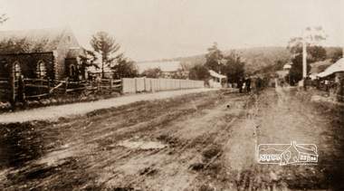 Eltham District Historical Society Inc
Photograph, Main Street, Greensborough, c.1910, 1910c
Early view of Main Street Greensborough showing the mainly residential nature of the buildings. Photographs from the collection of Peter Blackbourn, a descendant of the Chapman Stock family.Photograph copy originally located in a magnetic style album titled 'Greensborough Bypass 1990s 5' suffering significant degradation. No information contained in album or on reverse of photos except where noted. Relocated to archival photosafe storage.greensborough, main street -
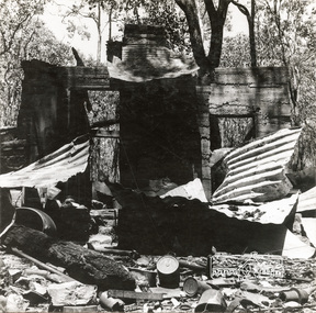 Eltham District Historical Society Inc
Photograph, George W. Bell, 'Windy' Gale's burnt out home, Wild Dog Creek Road, Jan. 1962, Jan 1962
Building of Pensioners Cottages at St Andrews; for those burnt out in the 1962 bushfires. A voluntary scheme of Mavis Gill through the Kangaroo Ground Relief CommitteeBlack and white photo mounted on card'Windy' Gale's burnt out home, Wild Dog Creek Road Photo Geo. W. Bell, Jan. 1962victorian bushfires - 1962, bushfires, dick (windy) gale, fire damage - buildings, george w bell, houses, st andrews, wild dog creek road, mavis gill, pensioners cottages -
 Eltham District Historical Society Inc
Photograph, George W. Bell, Mavis Gill making a turn near 'Windy' Gale's home, Wild Dog Creek Road, Jan. 1962, Jan 1962
Building of Pensioners Cottages at St Andrews; for those burnt out in the 1962 bushfires. A voluntary scheme of Mavis Gill through the Kangaroo Ground Relief CommitteeBlack and white photo mounted on cardMavis Gill making a turn near 'Windy' Gale's place Wild Dog Creek area Photo Geo. W. Bell, Jan. 1962victorian bushfires - 1962, bushfires, dick (windy) gale, fire damage - buildings, george w bell, houses, st andrews, wild dog creek road, mavis gill, pensioners cottages -
 Eltham District Historical Society Inc
Photograph, George W. Bell, Christmas Hills bushfire, Jan. 1962, Jan 1962
Building of Pensioners Cottages at St Andrews; for those burnt out in the 1962 bushfires. A voluntary scheme of Mavis Gill through the Kangaroo Ground Relief CommitteeBlack and white photo mounted on cardChristmas Hills bushfire Photo Geo. W. Bell, Jan. 1962victorian bushfires - 1962, bushfires, fire damage - buildings, george w bell, houses, st andrews, mavis gill, pensioners cottages, christmas hills, water tank -
 Eltham District Historical Society Inc
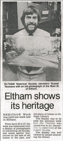
Photocopy of newsclipping, Eltham shows its heritage, c.1988, 1988c
From Leader Associated Newspapers - date unknown. Believe the photo was taken in Eltham Library in the former Shire of Eltham office building on Main Road, Eltham Photocopy of newsclippingactivities, main road, shire of eltham historical society, heritage week, russell yeoman