Showing 22330 items
matching parks
-
 Yarra City Council
Painting - Public Art, Rule 30
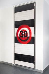
Clinton Naina’s earliest memory is attending Collingwood football matches at Victoria Park with his father and uncles. His dad was an avid Collingwood supporter and Naina proudly wore his football colours. Lining up to enter the grounds at the big old black-and-white painted wooden doors gave Naina the feeling of entering into another world. 'Rule 30' is a comment on race relations in sport. The artwork is made from the original doors located at the front entrance of the Collingwood Football Club’s grounds at Victoria Park. When the club was refurbished the door was gifted to Naina by a friend—an ex-Collingwood football player—for use in his art practice. The work depicts a big red target painted on the existing Black and white stripes—Collingwood colours—of the door. Naina placed a fabric number ‘30’ on top of the target—created from material used for numbers on the back of players’ football vests. This represents the individuals who have been racially vilified while playing football over many years. The red represents the colour of human blood, while the Blak and white Collingwood colours already painted on the wood are a very fitting comment on race relations. The door itself becomes a potent metaphor for “overcoming barriers, making change, breaking down doors and moving forth into a new era of respect for people”. Rule 30 in the AFL was the first racial vilification code in Australian sport. It prohibited conduct between players, clubs and other AFL officials, which threatened, disparaged, vilified or insulted another person on the basis of that person’s race, religion, colour, descent or ethnic origin. In 2013, ‘Rule 30’ was amended to ‘Rule 35’ to combat other forms of discrimination including disability, appearance and sexuality.The number '30' cut out of fabric placed on top of a painted red target at the centre of an existing black and white wooden door.Accompanying labelracism, sport, football, afl -
 Bendigo Historical Society Inc.
Document - BENDIGO MEMORIES, 1860 - 80
Typed notes titled ' Bendigo Memories, 1860 - 80'. Mentioned the Meudell family, some successful mine owners, the statue of the shepherd and the wild beast in the Conservatory Gardens, an argument over a rooster between two Chinese neighbours, Laying the Foundation Stone of the Sandhurst Masonic-Hall, a ring presented to Mr Lysaght by the Chinese, and 'It Slowly Fades Away' which is about a house near a tennis court which has an old brewery under the back garden.document, bendigo memories 1860 - 80, g d meudell, 'the pleasant career of a spendthrift', william meudell, bank of victoria (bendigo), hon henry miller, george lansell, bank of new south wales, oriental bank, union bank, adventure and advance mine, g ballerstedt, 180 mine, garden gully united co, john boyd watson, carlisle mine, kentish mine, barnett lazarus, william hunter, joseph hunter, robert hunter, burnewang park, william moffat, bendigo advertiser 1930, mr r buck, statue in conservatory gardens, bendigo advertiser 26/2/1949, mr wells, abraham harkness, alex h stone, bendigo advertiser 16/6/1868, sing toe, ming foy, mr flegg, mr mclachlan, mr w perry, laying the foundation stone of the sandhurst masonic-hall, messrs vahland and getzschmann, mr w c vahland, brother j m'intyre w m, brother buckley, brother connelly, golden and corinthian grand united lodge, the rev j c m'cullagh, brother g p joseph, the australasian sketcher 9/8/1873, chinese testimonial, mr lysaght, bendigo advertiser 27/11/1856, ben eagle, 'it slowly fades away', michelson home, joch, mr michelson -
 Bendigo Historical Society Inc.
Document - A HILL AND ITS ADMINISTRATION
Typed notes titled 'a Hill and its Administration'. It mentions the Gold Commissioners, mining licences, Red Ribbon Movement, the buildings around Commissioner's Hill, corrupt police, the iron lock up and the log lock up.document, a hill and its administration, mr horn, captain dana, asst commissioner gilbert, commissioner cockburn, capt john urquart, asst commissioner panton, asst commissioner reid, asst comm j m clow, comm wright, captain bull, asst comm joseph anderson panton, red ribbon movement, governor latrobe, mr thomson, police commissioner mitchell, col valiant, queen victoria, eureka riot, lt finch, mt alexander mail sat 9 sept 1854, bendigo sports centre, post office, garden gully goldmine, high school, old supreme court, st jean's hill, volunteer rifle corp, vic volunteer cal regiment, vol cavalry, bendigo art gallery, a n a lodge, a n a hall, goldfield police, m'lachlan, fly bros, hustlers park mine, bendigo advertiser 15 january 1857, bendigo gaol -
 Bendigo Historical Society Inc.
Document - LOCAL TREES - AND OTHERS
Typed notes on some trees planted in Bendigo. The Bunya Pine became popular and to a lesser extent, the Hoop Pine and were planted in people's gardens. Locations of Bunya Pine and some Hoop Pine are listed.document, local trees - and others, fortuna, 'bon acord', wm rae, conroy home, wittscheibe home, mr d shanks, mr & mrs e j howe, alex bain, girton college, joel horwood, dr backhaus, ernst mueller, rosalind park, canterbury park, eaglehawk cemetry, bendigo cemetry, white hills cemetry, kangaroo flat cemetry, r. a. -
 Moorabbin Air Museum
Manual (item) - F-86 Sabre Illustrated Parks Breakdown, Technical Manual: Illustrated Parts Breakdown USAF Series F-86F and RF-86F-30 Aircraft
Note at the top addresses the manual to Mr Bishop, CAC Fishermen's Bend -
Moorabbin Air Museum
Manual - CAC property census ICI deer park Robert Menzies phosgene TNT Nitro glycerine costings, CAC C7 ICI
-
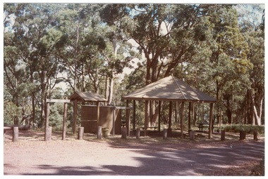 Buninyong & District Historical Society
Photograph - Colour photograph, Colour photograph of Mt. Buninyong picnic area
One of a series of photographs taken for Buninyong Shire Council 1980sMount Buninyong was reserved as a public park in 1866.Colour photograph of Mt Buninyong picnic areabuninyong shire council, mount buninyong, recreation, water tower, c.c.p. wilson -
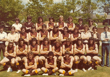 Galen Catholic College
Galen Catholic College's AMCO HERALD SHIELD football team, 1979
In 1979, Galen Catholic College put in a team in the AMCO HERALD SHIELD football competition. Galen College was up against some of the best school teams in Victoria. Some of the players in the 1979 team went on to play in the VFL in the 1980s. australian rules football, waverley park, galen catholic college, galen college, sport -
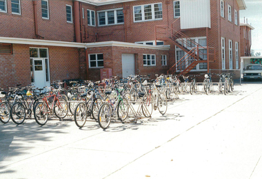 Galen Catholic College
Galen Catholic College Schoolyard in the early 1990s
These photos taken in the early 1990s, illustrate how some of the schoolyard looked at the time and how much it has changed since then.galen, galen catholic college, galen college, art, bike racks, car park -
B-24 Liberator Memorial Restoration Australia Inc
Oral History, My RAAF Experience by Keith R.E. Johnston, 1980's
K. Johnston was in the RAAF from September 1941 until December 1945 and was a B-24 Liberator pilot between 1942 and December 1945. He was attached to Fifth Bomber Command USAF the 12 Squadron RAAF.This oral history of Keith Johnston is of historical significance because it provides a first hand account of this individual's experiences during World War II as a member of the RAAF who trained at Bradfield Park Sydney and Bundaberg and saw active service during the Pacific conflict flying B-24 Liberator aircraft in New Guinea and Darwin.A4 paper printed transcript, stapled in cornerMy RAAF Experience by R.E.Johnston, photo of 12 Squadron RAAF badge, Flight Lieutenant 12 Squadron RAAForal history raaf world war ii -
B-24 Liberator Memorial Restoration Australia Inc
Oral History, A Navigator's War, 2000
I. Edmiston was in the RAAF from March 1942 until December 1945 and was a navigator on a B-24 Liberator between Early 1943 and June 1945 with Coastal Command and 160 Squadron.This oral history of Ian Edmiston is of historical significance because it provides a first hand account of the individual's experience during World War II as a member of the RAAF who trained at Cootamundra, Evans Head, Parkes, Prince Edward Island and the Bahamas Islands.He saw active service as navigator in a B-24 Liberator aircraft in the South East Asian Islands.A4 Paper printed transcript in plastic coverA Navigator's War. By Ian Edmistonoral history raaf world war ii -
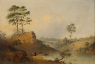 Benalla Art Gallery
Painting, Henry BURN, Studley Park bridge over the Yarra, c. 1860
Born: Birmingham, Warwickshire, England 1807; Arrived: Melbourne, Victoria, Australia 1853; Died: Melbounre, Victoria, Australia 1884RomanticismGift of Beverley Brown, 2015Oil painting on board, depicting sparse rural landscape by a river and bridge.Gold brushed timber frame and decorative gesso inner corners. Recto: Not signed, not dated, not titledpainting, landscape, figures, boat, tree, bridge, river, animals, water -
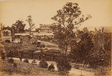 Bendigo Art Gallery
Photograph - Work on paper, Nicholas CAIRE, View from Camp Hill, Looking North East, 1875
Inscribed on original mountcard, l.l., gold letterpress, "N.J. CAIRE"bendigo, sandhurst, camp hill, rosalind park, photograph, work on paper -
 Horsham Regional Art Gallery
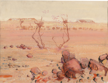
Painting, Clifton PUGH, Scene, Sturt National Park, 1968
Gift of Mack Jost, 1992 -
 Horsham Regional Art Gallery
Photograph, Les WALKLING, Croajingolong National Park, 1978
Purchased through the Horsham Art Gallery Trust Fund, 1994 -
 St Kilda Historical Society
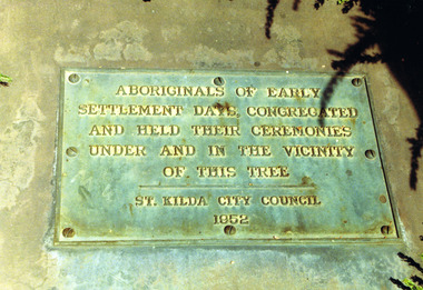
Photograph, Plaque at the Corroboree Tree, Albert Park
Aboriginals of Early Settlement days, congregated and held their ceremonies under and in the vicinity of this tree, St Kilda City Council 1952colour photograph, unmountedAboriginals of early settlement days congregated and held their ceremonies under and in the vicinity of this tree. St Kilda City Council, 1952. -
 St Kilda Historical Society
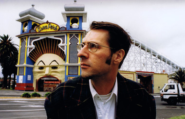
Photograph, Nigel Male, Rohan Storey
Rohan Storey, Architectural Historian of the National Trust of Australia (Victoria) 1990-2011.colour photograph unmountedPhotograph by Nigel Maleluna park, st kilda, rohan storey, national trust -
 St Kilda Historical Society
Photograph - Photo map, 28/01/1951
One of a series of photo-maps produced for the Department of Crown Lands and Survey (1857-1983). For correlation with a current map, and access to other historical photo maps of Victoria, see the Historic Photo-Maps Index published by the Department of Environment, Land, Water and Planning at https://services.land.vic.gov.au/DELWPmaps/historical-photomaps/Black and white aerial photograph1424-45 SECRET 534 Run 18 Lens 12" Melbourne Metropolitan 12150 28.1.51 M639albert park, st kilda junction, st kilda pier, catani gardens, st kilda, prahran, albert park lake, 1951, middle park, st kilda beach, windsor -
 St Kilda Historical Society
Photograph - Photo map, 28/01/1951
One of a series of photo-maps produced for the Department of Crown Lands and Survey (1857-1983). For correlation with a current map, and access to other historical photo maps of Victoria, see the Historic Photo-Maps Index published by the Department of Environment, Land, Water and Planning at https://services.land.vic.gov.au/DELWPmaps/historical-photomaps/Black and white aerial photograph1424-118 534 Run 20 Lens 12" Melbourne Metropolitan 12150 18.1.51M639elwood, point ormond, elwood park, elsternwick park, elwood beach, 1951 -
 St Kilda Historical Society
Photograph - Photo map, 30/01/1960
One of a series of photo-maps produced for the Department of Crown Lands and Survey (1857-1983). For correlation with a current map, and access to other historical photo maps of Victoria, see the Historic Photo-Maps Index published by the Department of Environment, Land, Water and Planning at https://services.land.vic.gov.au/DELWPmaps/historical-photomaps/Black and white aerial photographVic 1093-62 Melbourne & Metropolitan Project Run 21 30.1.60 Lens 10" 8.200middle park, albert park, catani gardens, st kilda west, 1960 -
 St Kilda Historical Society
Photograph - Photo map, 30/01/1960
One of a series of photo-maps produced for the Department of Crown Lands and Survey (1857-1983). For correlation with a current map, and access to other historical photo maps of Victoria, see the Historic Photo-Maps Index published by the Department of Environment, Land, Water and Planning at https://services.land.vic.gov.au/DELWPmaps/historical-photomaps/Black and white aerial photographVic 1093-60 Melbourne & Metropolitan Project Run 21 30.1.60 Lens 10" 8.200st kilda, albert park, prahran, windsor, south yarra, 1960 -
 St Kilda Historical Society
Photograph - Photo map, 30/01/1960
One of a series of photo-maps produced for the Department of Crown Lands and Survey (1857-1983). For correlation with a current map, and access to other historical photo maps of Victoria, see the Historic Photo-Maps Index published by the Department of Environment, Land, Water and Planning at https://services.land.vic.gov.au/DELWPmaps/historical-photomaps/Black and white aerial photographVic 1092-42 Melbourne & Metropolitan Project Run 22 30.1.60 Lens 10" 8.200malvern, caulfield, caulfield park, 1960 -
 St Kilda Historical Society
Photograph - Photo map, 30/01/1960
One of a series of photo-maps produced for the Department of Crown Lands and Survey (1857-1983). For correlation with a current map, and access to other historical photo maps of Victoria, see the Historic Photo-Maps Index published by the Department of Environment, Land, Water and Planning at https://services.land.vic.gov.au/DELWPmaps/historical-photomaps/Black and white aerial photographVic 1091-112 Melbourne & Metropolitan Project Run 23East 30.1.1960 Lens 10" 8.200elwood, point ormond, elwood park, elwood canal, 1960 -
 St Kilda Historical Society
Photograph - Photo map, 30/01/1960
One of a series of photo-maps produced for the Department of Crown Lands and Survey (1857-1983). For correlation with a current map, and access to other historical photo maps of Victoria, see the Historic Photo-Maps Index published by the Department of Environment, Land, Water and Planning at https://services.land.vic.gov.au/DELWPmaps/historical-photomaps/Black and white aerial photographVic 1091-110 Melbourne & Metropolitan Project Run 23East 30.1.60 Lens 10" 8.200elwood, elsternwick, elsternwick park, ripponlea, st kilda east, caulfield, balaclava, 1960 -
 St Kilda Historical Society
Photograph - Photo map, 30/01/1960
One of a series of photo-maps produced for the Department of Crown Lands and Survey (1857-1983). For correlation with a current map, and access to other historical photo maps of Victoria, see the Historic Photo-Maps Index published by the Department of Environment, Land, Water and Planning at https://services.land.vic.gov.au/DELWPmaps/historical-photomaps/Black and white aerial photographVic 1091-1 Melbourne & Metropolitan Project Run 24East 30.1.60 Lens 10" 8.200elwood, elwood beach, elwood park, 1960 -
 St Kilda Historical Society
Photograph - Photo map, 30/01/1960
One of a series of photo-maps produced for the Department of Crown Lands and Survey (1857-1983). For correlation with a current map, and access to other historical photo maps of Victoria, see the Historic Photo-Maps Index published by the Department of Environment, Land, Water and Planning at https://services.land.vic.gov.au/DELWPmaps/historical-photomaps/Black and white aerial photographVic 1091-2 Melbourne & Metropolitan Project Run 24East 30.1.60 Lens 10" 8.200elwood, elwood park, elwood beach, elsternwick park, 1960 -
 St Kilda Historical Society
Photograph - Photo map, 3/3/1964
One of a series of photo-maps produced for the Department of Crown Lands and Survey (1857-1983). For correlation with a current map, and access to other historical photo maps of Victoria, see the Historic Photo-Maps Index published by the Department of Environment, Land, Water and Planning at https://services.land.vic.gov.au/DELWPmaps/historical-photomaps/Black and white aerial photographVic 1833 Melbourne 1963 Project Run 15 3.3.64 Lens 205 152.70 M/M 5.150 56prahran, fawkner park, south yarra, albert park, 1964 -
 St Kilda Historical Society
Photograph - Photo map, 14/12/1963
One of a series of photo-maps produced for the Department of Crown Lands and Survey (1857-1983). For correlation with a current map, and access to other historical photo maps of Victoria, see the Historic Photo-Maps Index published by the Department of Environment, Land, Water and Planning at https://services.land.vic.gov.au/DELWPmaps/historical-photomaps/Black and white aerial photographVic 1807 Melbourne 1963 Project Run 16 14.12.63 Lens 205 152.70 M/M 5.150 179st kilda, prahran, albert park, st kilda east, balaclava, 1963 -
 St Kilda Historical Society
Photograph - Photo map, 14/12/1963
One of a series of photo-maps produced for the Department of Crown Lands and Survey (1857-1983). For correlation with a current map, and access to other historical photo maps of Victoria, see the Historic Photo-Maps Index published by the Department of Environment, Land, Water and Planning at https://services.land.vic.gov.au/DELWPmaps/historical-photomaps/Black and white aerial photographVic 1806 Melbourne 1964 Project Run 18 14.12.63 Lens 205 152.70 M/M 5.150 161elsternwick, elsternwick park, elwood, elwood canal, elwood beach, elwood park, 1963 -
 St Kilda Historical Society
Photograph - Photo map, 12/04/1966
One of a series of photo-maps produced for the Department of Crown Lands and Survey (1857-1983). For correlation with a current map, and access to other historical photo maps of Victoria, see the Historic Photo-Maps Index published by the Department of Environment, Land, Water and Planning at https://services.land.vic.gov.au/DELWPmaps/historical-photomaps/Black and white aerial photographVic 1933 Melbourne 1966 Project Run 12 12.4.66 Lens 122 151.75MM 9.800 152st kilda, st kilda pier, st kilda marina, albert park, fawkner park, windsor, south yarra, prahran, st kilda west, middle park, st kilda beach, 1966