Showing 110201 items matching "roads"
-
 Geelong Cycling Club
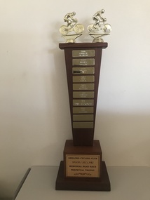
Trophy
Messrs Wood and Sellars names are on the trophy in recognition of their service to the Geelong Cycling Club.Club volunteers are important to the club and this trophy serves to recognise endeavours in this field. This trophy is in the shape of a wooden column set on two small wooden bases. The second base has a plaque attached to it with the title of the trophy. The column of the trophy has small rectangular plaques with the name of each winner inscribed on them dated from 2006-2016. Images of two cyclists in an embossed gold colour are fixed to the top of the trophy. "Geelong Cycling Club/Wood/Sellars/Memorial Road Race/Perpetual Trophy/2006/Andrew Graham/2007/Terry Stacy/2009/Brian Happ/2012/Ned Volk/2013/Paul Rettke/2014/Shantelle Maurer/2015/Tony MacKenzie/2016/Josh Williams"geelong cycling club; wood; sellars; andrew graham; terry stacy; brian happ; ned volk; paul rettke; shantelle maurer; tony mackenzie; josh williams; -
 Warrnambool and District Historical Society Inc.
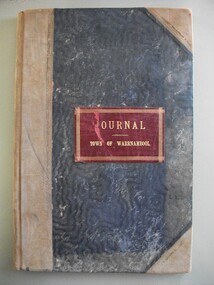
Financial record - Journal Town of Warrnambool 1914-1926, Circa 1914
This journal shows payments made for a number of Council and community expenses. It includes entries relating to Town Hall, Botanic gardens, Parks, road costs, baths, beach improvements, Warrnambool Racing Club. It shows account transfer journals Provides an overview of expenses of Council in the early 20th century.Dark blue water wave fabric over card with light brown points and binding. Red leather label with gold text and border. Pages edged in pink green, yellow and white pattern. 102 Pages.Journal Town of Warrnambooltown of warrnambool 1914-1926, warrnambool expenses 1920, warrnambool town hall, warrnambool baths -
 Warrnambool and District Historical Society Inc.
Financial record - Ledger Warrnambool City Council cash book 1940-1946, Circa 1940
This cash book contains details of payments made and money collected from the period 1940-1946 There are expenses such as road maintenance, stationery, Abattoirs, ice, Botanic Gardens, Booval Gardens, beach improvements, sanitary services, salaries and wages.This cash book provides a detailed description of the day to day expenses of running a city council in the 1940’s. Large green cloth hard cover with tan point and spine. Inside front and back covers is patterned red and blue with thick black diagonal lines. It has binding tape inside front and rear covers. 201 pages edged in pink, green, yellow, and white. The pages have the heading in black print, “City Of Warrnambool.”Label inside front cover,” E. Whitehead & Co, Pty Ltd, Stationers, general Printers and Account Book Manufacturers, Griffin House, 21 Equitable Place, Melbourne. Ref No. 16380. warrnambool city expenses 1940, warrnambool city ledger 1940-1946, warrnambool history -
 Eltham District Historical Society Inc
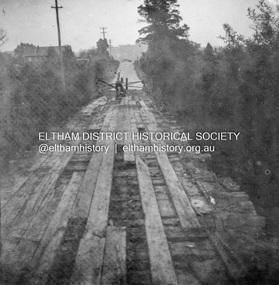
Album - Photograph, J.A. McDonald, Eltham-Greensborough Road, 26 July 1956
Diamond Creek Bridge (Bridge Street Bridge) Old bridge from N.W. bank Handrails stripped – 26/7/56 View looking west along bridge to Susan Street intersection with barriers placed across the roadRecord of various Shire of Eltham infrastructure works undertaken during the period of 1952-1962 involving bridge and road reconstruction projects, sometimes with Eltham Shire Council Project Reference numbers quoted. It was during this period that a number of significant improvements were made to roads and new bridges constructed within the shire that remain in place as of present day (2022). In many situations, the photos provide a tangible visible record of infrastructure that existed throughout the early days of the Shire. The album was put together by or under the direction of the Shire Engineer, J.A. McDonald.infrastructure, road construction, shire of eltham, bridge construction, bridge street bridge, eltham, eltham-greensborough road, 1956-07-26 -
 Eltham District Historical Society Inc
Document - Property Binder, 967 Main Road, Eltham
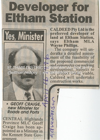
Newspaper article: Developer for Eltham Station, The Advertiser, April 16, 1996 The original Station Master's house situated in present-day bus bay was sold in 1986 for $1 to save it from demolition and was then relocated to 58 Park Road.58 park road, 967 main road, businesses, eltham, eltham railway station, houses, main road, property, station masters house, station master's house eltham -
 Eltham District Historical Society Inc
Document - Folder, Powell, Margaret
Margaret Powell taught and exhibited pottery, to hold her first solo exhibition at her studio home, Haldane Road, Eltham. Contents Newspaper article: "First solo show", No masthead, no date. Margaret Powell's career as a potter.Newspaper clippings, A4 photocopies, etcmargaret powell, haldane road eltham, diamond valley arts society -
Glen Eira Historical Society
Document - Hall, Hugh Percival
Typed biography on the life and times of Hugh Percival Hall, by his daughter Felicitie E. Campbell dated March 2006. He was a solicitor, artist and photographer and his grand-father built Glenmoore in St. George’s Road, Elsternwick.artists, hall hugh percival, caulfield grammar school, glenmoore, mansions, house names, ballet in australia from pavlova to rambert, photography, statues, watkin joyce leslie, moore hugh, hall felicitie elizabeth, campbell felicitie elizabeth, campbell andrew john egan, campbell carol, meares diugan and hall, ballet and dance, campbell alistair, campbell ross, campbell robyn, campbell lynette, glen eira road, steadman cameron meares and hall, tennis courts -
Glen Eira Historical Society
Article - Esakoff, Margaret
Article from The Age dated 18/08/2011 titled Mayor’s Husband Lobbied on Heritage. Refers to a property on corner Hawthorn Road and Seaview Street, Caulfield South. Considerable council debate on Heritage Protection was generated by this situation.esakoff margaret mayor, seaview street 2a and 2b, caulfield south, heritage protection, glen eira council, hawthorn road, briggs john, esakoff john, hyams jamie -
 Eltham District Historical Society Inc
Document - News Clipping, Auction - Part of Eltham history
Copy of undated article headed "Auction part of Eltham history" regarding sale of property at 816 Main Road, Eltham (In March 2020 the site of Goodstart Early Learning Eltham) on the corner of John Street owned by the Burgoyne Family.1 page A4 photocopyHG Booklet 37816 main road, burgoyne, h. burgoyne, harry burgoyne, harry gilham collection, hawthorns, john james thomas neville burgoyne -
 Eltham District Historical Society Inc
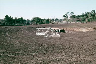
Slide, Construction of Eltham Town Park, 25 Jul 1973
Construction of Eltham Town Park; landscape has been scupltured and lakes formed. Shillinglaw Cottage , Main Road, Eltham Shire Council Offices and Catholic Church all visible. The park was later renamed Alistair Knox Park.35 mm colour positive transparency Mount - Agfacolor Service (Blue)Memorial Park 25 July 1973eltham, main road, alistair knox park, eltham town park, shillinglaw cottage, bridge street -
 Phillip Island and District Historical Society Inc.
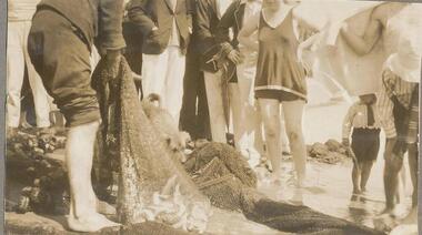
Photographs, 1926
Part of a collection of photographs from an old photo album with multiple photos per page. Donated by Margaret Webster. Her parents were Sir Charles & Lady McGrath who lived on Ventnor Road, Cowes near the RSL286-12 - Sepia photograph of a group of people with a net of fish at Cowes, Phillip Island. 286-13 - Sepia photograph of two women on the beach at Newhaven, Phillip Island. 286-14 - Sepia photograph of three people and a car at Newhaven, Phillip Island. 286-15 - Sepia photograph of a woman holding a Mutton Bird. 286-16 - Sepia photograph of Forrest Caves, Phillip Island. 286-17 - Sepia photograph of three people on rocks at Forrest Caves, Phillip Island.286-12 - "A haul of trout, Cowes." 286-13 - "Newhaven, Phillip Island" 286-14 - "A rest a Newhaven P.I." 286-15 - "A Mutton Bird P.I." 286-16 - "The Caves P.I." 286-17 - "Forest Caves P.I." (Should be "Forrest" with two "r's")forrest caves phillip island, fishing catch, newhaven, mutton bird, native wildlife, margaret webster -
 Phillip Island and District Historical Society Inc.
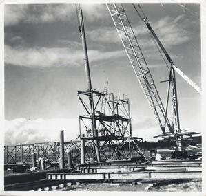
Photographs, Phillip Island 2nd Bridge Construction, 1966 - 1969
22 of a collection of 70 Black & White photographs taken during the construction of the second Phillip Island Bridge from San Remo to Newhaven by Country Roads Board and Shire of Bass. Contractor John Holland & Co. Pty. Ltd.14 Black & White photographs of the construction of the second Phillip Island Bridge in 1966 - 1969. 351-09: Pile driving on Newhaven abutment. 351-10 & 11: Concrete beams. 351-12: Pile driver. 351-13 & 14: Machinery. 351-15: Dismantled section of cylinder. 351-16 & 17: Coffer dam and pier construction. 351-18: Man up on scaffold. 351-19 & 20: Construction work. 351-21: Two workmen and man leaning on section of handrail exposed to weather. 352-22: View of construction work.Descriptions as above on some. Plus the following Numbering: 351-09: CRB NEG 67-274C. 351-10: CRB NEG 67-542. 351-11: CRB NEG 67-654F. 351-12: CRB NEG 66-605. 351-13: CRB NEG 66-601. 351-14: CRB NEG 68-752B. 351-15: CRB NEG 67-936. 351-16: CRB NEG 67-937A. 351-17: CRB NEG 67-937B. 351-18: CRB NEG 67-1156D. 351-19: CRB NEG 67-1156B. 351-20: CRB NEG 66-1026E. 351-21: CRB NEG 67-940. 351-22: CRB NEG 67-1218Bphillip island bridge construction, 2nd phillip island bridge construction, country roads board, shire of bass, sasha stark -
 Phillip Island and District Historical Society Inc.
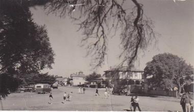
Photograph, San Remo
Broad view of The Esplanade beneath an overhanging branch of tree, looking at hotels and shops. On the right is a large bush to the left a large tree. A bus, car and truck are parked to left and unidentifiable figures of people walking to and fro across the road.Esplanade, San Remolocal history, photographs, san remo, black & white photograph, mona condrick -
 Greensborough Historical Society
Photograph - Digital image, Caroline and Ferdinand Barnett and sister, 1940c
Caroline and Ferdinand Barnett and his sister Emily Barnett from Northcote. Taken at 122 Main Road Lower Plenty. Photographs from the collection of Peter Blackbourn, a descendant of the Chapman Stock family. Annotations to photos by Peter Blackbourn.Digital copy of black and white photograph.peter blackbourn, caroline barnett, ferdinand barnett, emily barnett, 122 main road lower plenty -
 Greensborough Historical Society
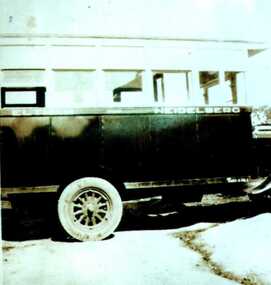
Photograph - Digital image, Heidelberg Eltham bus, 1929c
Heidelberg-Eltham bus, run by Alf Barnett then his brother Stan Barnett. This photograph taken at Bannockburn Road, late 1920s.Photographs from the collection of Peter Blackbourn, a descendant of the Chapman Stock family. Annotations to photos by Peter Blackbourn.Digital copy of black and white photograph.peter blackbourn, alf barnett, stan barnett, heidelberg-eltham bus -
 Greensborough Historical Society
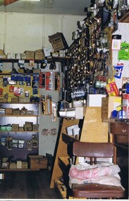
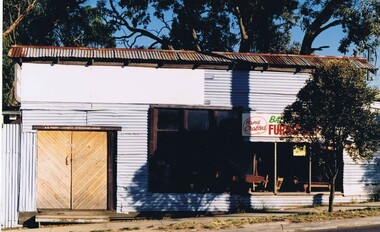
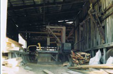
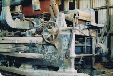
Photograph - Digital image, Frank Solomon, Briar Hill Timber 1, 2012c
Briar Hill Timber was situated on Sherbourne Road Briar Hill and operated as a timber yard for many decades from he 1950s. These photographs were taken by Frank Solomon and depict the business just prior to its closure in 2014.Digital copy of colour photographbriar hill timber -
 Greensborough Historical Society
Photograph - Digital image, Frank Solomon, Briar Hill Timber 2, 2010c
Briar Hill Timber was situated on Sherbourne Road Briar Hill and operated as a timber yard for many decades from he 1950s. These photographs were taken by Frank Solomon and depict the business just prior to its closure in 2014.Digital copy of colour photographbriar hill timber -
 Greensborough Historical Society
Photograph - Digital image, Frank Solomon, Briar Hill Timber 3, 2012c
Briar Hill Timber was situated on Sherbourne Road Briar Hill and operated as a timber yard for many decades from he 1950s. These photographs were taken by Frank Solomon and depict the business just prior to its closure in 2014.Digital copy of colour photographbriar hill timber -
 Greensborough Historical Society
Photograph - Digital image, Frank Solomon, Briar Hill Timber 5, 2012c
Briar Hill Timber was situated on Sherbourne Road Briar Hill and operated as a timber yard for many decades from he 1950s. These photographs were taken by Frank Solomon and depict the business just prior to its closure in 2014.Digital copy of colour photographbriar hill timber -
 Greensborough Historical Society
Leaflet, Colin Brooks, Putting people first, 2016_
Information brochure from Colin Brooks MP detailing improved educational funding for Greensborough Primary School, Bundoora Primary School, Kingsbury Primary School, Greensborough College and Greensborough TAFE, with a number of public transport and road improvementsDouble sided coloured brochureprimary schools greensborough, public transport, colin brooks -
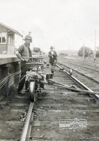 Eltham District Historical Society Inc
Photograph, Jim Jenkins, probably at Eltham Railway Station
Jim Jenkins worked for the Railways and lived in York Street (Source: Electoral Rolls) Pages from a scrapbook belonging to Heather Jenkins (nee Sargeant) who lived as a child in the Police Residence at 728 Main Road, Eltham in the 1920s.Heather Sargeant was the daughter of Constable W.C. Sargeant, the local police officer in residence at Eltham, 1922-1927Glued on a brown paper scrapbook page (torn from scrapbook) with 9 black and white/sepia photos of varying sizes, 1 newspaper clipping and handwritten captions in ink.On verso in pencil "Const. W.C. Sargeant 1922-1927 - see Police list"heather jenkins (nee sargeant), eltham, police residence, constable w.c. sargeant, jim jenkins, eltham railway station, railway line -
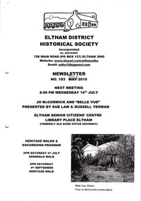 Eltham District Historical Society Inc
Newsletter, Newsletter, No. 193 July 2010
Contents: • Next meeting, guest speaker; Sue Law and Russell Yeoman: Jo McCormick and ‘Belle Vue’ • July Meeting • Edendale Walk • Local Road and Street Names by Russell Yeoman • The Christmas Hills Story • More News The Shire of Eltham Historical Society was formed in October 1967. The first newsletter of the Society was issued May 1978 and has been published continuously ever since on a bi-monthly basis. With the cessation of the Shire of Eltham in late 1994, the Society's name was revised to Eltham District Historical Society and this name first appeared with issue No. 103, July 1995. The collection of the Society's newsletters provides a valuable resource on the history of the Society's activities, office bearers and committee members, guest speakers and subjects of historical interest pertinent to the former Shire of Eltham and the Eltham District.A4 photocopied newsletter distributed to membersnewsletter, eltham district historical society, shire of eltham historical society -
 Eltham District Historical Society Inc
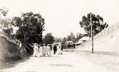
Photograph postcard, Nearing the Station; postcard from Emily for Christmas
View looking north along Main Road from Bridge Street to York Street. Shillinglaw Cottage and the Shillinglaw trees are visible in the centre distance. Possibly Sunday sightseers who have come out on the train from Melbourne. Digital file only Postcards scanned from the collection of Michael Aitken on loan to EDHS, 13 Feb 2018michael aitken collection, postcards, eltham, main road, shillinglaw cottage, shillinglaw trees, york street, bakery -
 Eltham District Historical Society Inc
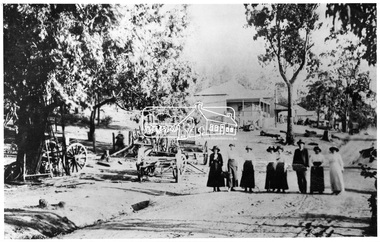
Negative - Photograph, Tom Prior, Main Road, Hurstbridge, c.1912
Seven women and one man strolling down Main road, Hurstbridge. They have possibly arrived for a visit on the train, when the railway line was extended from Eltham to Hurstrbridge in 1912. This photo is also contained in the Reynolds-Prior CollectionThis photo forms part of a collection of photographs gathered by the Shire of Eltham for their centenary project book, "Pioneers and Painters: 100 years of the Shire of Eltham" by Alan Marshall (1971). The collection of over 500 images is held in partnership between Eltham District Historical Society and Yarra Plenty Regional Library (Eltham Library) and is now formally known as 'The Shire of Eltham Pioneers Photograph Collection.' It is significant in being the first community sourced collection representing the places and people of the Shire's first one hundred years. The Reynolds family were early settlers in Research. The Reynolds/ Prior collection of photographs were taken by Tom Prior, the maternal uncle of Ivy Reynolds, around 1900 and the 60 photos in the album give a fine overview of many of the landmarks of Research and Eltham over 100 years ago. lvy lived in the family home for many years at 106 Thompson Cres Research. Ivy's father, Ernst Richard Reynolds and grandfather, Richard Reynolds, lived at the same address. Ivy's father Richard worked for Mr. Trail on his property in Research. Reynolds Road is named after the family. Mr Tom Prior (wife Eva) worked at the Melbourne zoo. He was very innovative and made his own camera, using the black cloth hood to exclude the light. The photographs are a reminder of the rural nature of Research and Eltham and its rich heritage.Digital image 4 x 5 inch B&W Negsepp, shire of eltham pioneers photograph collection, hurstbridge, main road, reynolds prior collection -
Glen Eira Historical Society
Map - CAPLES PLACE SUBDIVISION
This file contains a copy of a map of the CAPLES PLACE SUBDIVISION, undated and author unknown. The map provides the dimensions of roads and allotments in the area, including also handwritten notes from the original document and others written directly onto the copy.land subdivisions, documents, maps, glen eira, caples place, caples place subdivision, land surveys, orrong road, mulgrave road, prahran grove, somerset road, prahran grove, prahran grove, east walk, land allotments, town planning, garden road -
 Federation University Historical Collection
Map, Municipality of Ballarat East, 1857
Gold was discovered in Ballarat in 1851. This plan was created six years later and names some of the great gold locations of Ballarat East. It also shows the locality of the Eureka Stockade (1854) and the walking tracks and roads on the Ballarat East Goldfield.In 2007 this map was listed on the inaugural Ballarat Treasure's Register.Large map backed onto linen. The map has read and blue highlights, and identifies areas such as Mount Pleasant, Golden Point, White Flat, Nightingale, Malekoff, Old Post Office Hill, Red streak, Gumtree Flat, Old Gravelpits, Bakery Hill, Ballaarat Flat, The Camp, Specimen Gully, Pennyweight Hill, Warrenheip Gully, Gays Gully, Pennyweight Flat, Eureka, Black Hill, Pinchgut, Crocodile, Hit or Miss, Little Bendigo, Brown Hill, Mopoke, Cricket Reserve, Canadian Hotel, Ballarat Eastmount pleasant, golden point, white flat, nightingale, malekoff, old post office hill, red streak, gumtree flat, old gravelpits, bakery hill, ballaarat flat, the camp, specimen gully, pennyweight hill, warrenheip gully, gays gully, pennyweight flat, eureka, black hill, pinchgut, crocodile, hit or miss, little bendigo, brown hill, mopoke, cricket reserve, canadian hotel, ballarat eastm phillips, john phillips, field draughtsman, ballarat east, ballarat east map -
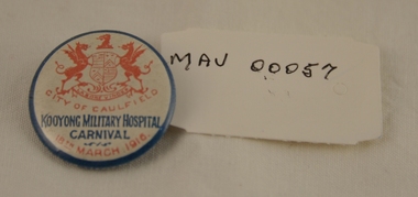 City of Moorabbin Historical Society (Operating the Box Cottage Museum)
Badge - World War 1914 - 1918, Badge fund-raising, c1916
The Kooyong Military Hospital in Kooyong Road, Caulfield was established for the care and rehabilitation of soldiers injured in World War 1. Many events like carnivals were held by the Red Cross to raise funds for the war effort and entertain the patients.This badge is a reminder of the Community support for injured soldiers when they returned from WW1 conflict and were hospitalized at Kooyong Military Hospital Caulfield 1914 - 1948 This badge was displayed at the GECC 'Wounded Soldier WW1 1914-1918 Exhibition" 2016 at Glen Eira Town Hall Caulfield A small tin button, with pin attachment at the back. The button was produced and sold as a fund-raiser for the Kooyong Military Hospital during the World War1, 1914-18, at that organisation's Carnival held on March 18th 1916. The front of the button is white with a blue perimeter. A copy of the City of Caulfield's Coat-of- Arms and the words, City of Caulfield, is written on the front of the button, as is the date 18th March 1916. Both the above are written in red. Kooyong Military Hospital is written in blue. ww1, 1914-18, kooyong military hospital, war casualties, caulfield, moorabbin, bentleigh, carnivals, fundraising, patriotism, anzac, australian commonwealth military forces -
 Victorian Interpretive Projects Inc.
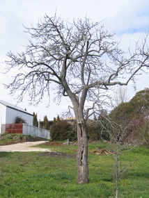
Photograph - Colour, Clare Gervasoni, Fabrizio Crippa's Pear Tree, Hepburn Springs, 27/08/2006
Fabrizio Crippa of Monza, Italy built a double storey villa in 1864 on the Main Road in Hepburn Springs. The surrounding land was planted with vines and fruit trees. The pear tree is most probably one of Fabrizio Crippa's original plantings.Am old pear tree stands in a garden with a building in the back ground. hepburn, hepburn springs, pear, villa parma, parma house, crippa, fabrizio crippa -
 City of Whittlesea
Archive - Cr L P Mitchell Collection, Councillor Laurence Mitchell Collection
Cr L P Mitchell was a councillor with the Shire of Whittlesea from 1947 until the 1970s. He was Shire president in 1954. The Laurimar estate on Yan yean road Doreen is named after the Counillor and his wife - Laurence and Mary.4 components of this collection: compact, medal, dress and documentsCompact inscription: Presented to Mrs L P Mitchell from Debs 1955 Medal inscription: Royal Agricultural Society of Victoria. Not transferrable 1958. (member no) 1996 -
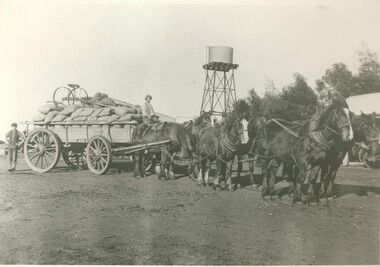 Lake Bolac & District Historical Society
Black and white photograph, Carting wheat on "Bellevue", c.1910
On the road in front of "Bellevue", Lake Bolac, circa 1910. A load of wheat is ready for the trip to the railhead at Willaura. Seated on the wagon is Bert Moreton and standing at the rear is Harry Hewitt. Note the home-made gig perched on top of the load.lake bolac, bellevue, moreton, hewitt, wheat, willaura,