Showing 3184 items matching "1886."
-
 Bendigo Historical Society Inc.
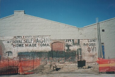
Photograph - Cnr Mundy & Mollison Streets, Bendigo
This site was originally that of Cobb and Co's livery stable and although the Cobb and Co office in the Shamrock Hotel closed in 1886, the livery stable continued with the proprietors, Robertson and Wagner and Co. The site was bought in August 1898 by the Fresh Food and Frozen Storage Co, proprietors of the Bendigo Butter Factory. On this site the company built an ice tory, refrigerating works and cool storage for other businesses. The Bendigo Butter Factory was begun in 1894 in Lucan Street, opposite the distillery, by Mr McIntyre of the Rochester district. This site included a butter printer and Weigher supplied by Cherry and Son of Gisborne. In September 1895 the Butter factory was floated as a public company and was registered by Mr J H Curnow. However the factory was not financially sound at this point and entered into receivership in 1896. At this time it was bought by the Fresh Food and Frozen Storage Company of Melbourne and was placed under the management of James Cumming, an experienced dairyman. The company had previously appointed him as their inspector of creameries. By 1911 he was the propietor of the Flora Hill Butter Factory. and was later killed in a car accident in May 1937. By 1919 the manager was Douglas Orson Oldfield (1868-1944) (NB at birth he was registered as Dugald and throughout his life he was also known as Dan).Colour photograph. Building on the corner of Mundy & Mollison Streets, Bendigo (opposite the former Gravel Hill State School). Building was formerly Charlton's Cobb & Co. building, and latter Bendigo Butter factory.cnr mundy & mollison streets, charlton's cobb, bendigo butter factory -
 Unions Ballarat
Minutes of meetings of the Congress Committee, June 1890-28 May 1891
Ballarat Trades Hall was part of the Intercolonial Trades Hall Congresses created for the purposes of collective organising within labour organisations. There were eight Congresses held within Australia: - 1879 Sydney - 1884 Melbourne - 1885 Sydney - 1886 Adelaide - 1888 Brisbane - 1889 Hobart - 1891 Ballarat (after the Maritime Strike in 1890) The political organisation of the labour movement and of restructuring trade union organisation under the Australasian Federation of Labour were significant agenda items. - 1898 Adelaide The following items were regularly discussed: - legislation of trade unions- organisation of labour - abolition of ‘Chinese and coolie immigration’ - Compulsory Court of Arbitration - Employers Liability Act - legalisation of the 8 hours system - land nationalisation - manhood suffrage - direct representation of labour in Parliament - appointment of working men on technical and other boards - free compulsory and secular education by the state and regulation of apprentices. Some of the resolutions passed were about: - Commonwealth Draft Bill - assisted immigration - payment to Members of Parliament - single tax, paid union organisers - minimum wage and industrial federation. See also http://archives.anu.edu.au/files/document-collection/intercolonial-trade-union-congresses-web-final.pdfTopics of discussion show the union/labour movement's ongoing activism and engagement on parliamentary and union matters, organising and employment on a national scale.1 volumeunions, organising, ballarat trades hall, ballarat trades and labour council, legislation, immigration, court of arbitration, employers liability act, land nationalisation, manhood suffrage, parliament, education, taxation, union organisers, wages, commonwealth draft bill -
 Ballarat and District Irish Association
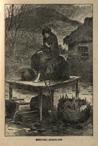
Image, Evicted - Homeless, 1864, c1864
Absentee landlords were common in Ireland and for many landlords the primary focus was income rather than the conditions of their tenants. Many landlords realized that they could get a higher income by turning their properties to pasture than to continue with the old practice of collecting rents from tenant farmers. Evictions was the most common way of getting rid of unwanted tenants. The tenant frequently built his cottage himself from local materials. However, his rent was higher if he had windows, if his door was over a certain height and if he made any type of improvements or enlargements to the dwelling. The landlords practiced "Rack Renting" in order to get rid of unwanted tenants. Rents were raised to the point that the tenant could not afford to pay them. The landlord then had the tenant evicted for non payment of rent. There were no appeals and no mercy shown. Although the only legal reason for eviction was non payment of the rent there were numerous examples of landlords who evicted tenants if they did not conform to the landlord's wishes.[http://www.maggieblanck.com/Mayopages/Eviction.html, accessed 13/12/2013] This image was also printed in he Illustrated London News, April 17, 1886, with the title 'all that is left, scene at a Mayo Eviction. A barefoot woman sits on a table in the rain, outside a cottage with thatched roof. She is surrounded by her possessions.ballarat irish, eviction, rent, cottage, tenant, homeless, mayo -
 University of Melbourne, School of Chemistry
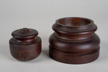
Container
Large dark wooden one fits the dish ordered by D.O.Masson shortly after arrival in Melbourne. (Sir) David Orme Masson was Professor of Chemistry at the University of Melbourne from 1886 to1923. As well as being a distinguished teacher and researcher, he contributed significantly to Australian scientific and public life, being instrumental in the establishment and governance of many important bodies including the CSIRO. Masson supported Antarctic research for 25 years, beginning with Douglas Mawson?s expedition of 1911. Born in England and receiving an MA, BSc and DSc from the University of Edinburgh, he was a gifted, elegant and disciplined lecturer and a researcher of substance. His research work included the theory of solutions, from which emerged the term ?critical solution temperature?; the periodic classification of the elements; and the velocity of migration of ions in solutions. Much of his research was done in collaboration with talented students such as David Rivett and his own son Irvine Masson. Masson was knighted in 1923. He is commemorated by the Masson Theatre and Masson Road at the University of Melbourne; a mountain range and island in Antarctica; a portrait painting by William McInnes in the foyer of the School of Chemistry; the Masson lectureship from the Australian National Research Council; and the Masson memorial scholarship from the Royal Australian Chemical Institute.Wooden containers (formers) -
 Orbost & District Historical Society
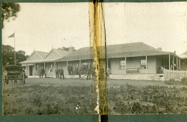
black and white photograph, C1900
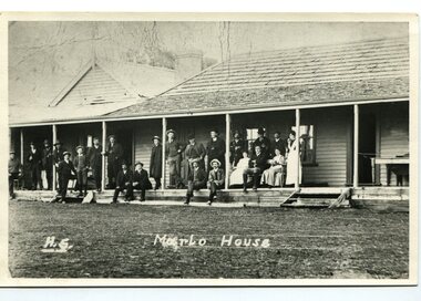
The first settler to occupy the Marlo township area was James Stirling around the year 1875. He built a bark hut on the bluff that had two rooms, bark walls, earthen floors and a shingle roof. By 1884, this structure had expanded to a 9 roomed accommodation house and in 1886 became the Marlo Hotel when a liquor license was granted. The Governor-in-Council declared Marlo to be a township on 18 February 1889. During May 1889, the government surveyor, E.L. Bruce set out 19 sections of the new township, with the first sales of subdivided land occurring the following May. At this time, Stirling's Marlo Hotel was the unofficial hub for the community. It was a general store, accommodation house and the unofficial post office, with settlers taking turns in bringing the mail from Orbost or Cunningham. This continued until Aug 1942, and in 1969 was located in a house adjacent to the Marlo Hotel, before being transferred to the Marlo General Store in this year. The official Post Office List states the Marlo Post Office opened around 1902. in 1925, the "Marlo House" (a nine room accommodation guest house) was granted a liquor licence. The "Marlo House" became "The Marlo Hotel". The Marlo Hotel was popular with many Orbost and district settlers, who travelled to Marlo by horseback or buggy. The Marlo Hotel, perched on the hill overlooking the estuaries and the entrance is a significat building in Marlo. Established in 1886, it has been operating for over 120 yearsA black / white photograph of the Marlo Hotel. Patrons are standing on the verandah and lawns. A horse-drawn carriage is on the left. The photograph is on a green buff card with a rough edge on R H side.on back - " Old Marlo Hotel"marlo-house marlo-hotel stirling-james -
 Orbost & District Historical Society
black and white photograph, C 1900
The first settler to occupy the Marlo township area was James Stirling around the year 1875. He built a bark hut on the bluff that had two rooms, bark walls, earthen floors and a shingle roof. By 1884, this structure had expanded to a 9 roomed accommodation house and in 1886 became the Marlo Hotel when a liquor license was granted. The Governor-in-Council declared Marlo to be a township on 18 February 1889] During May 1889, the government surveyor, E.L. Bruce set out 19 sections of the new township, with the first sales of subdivided land occurring the following May. At this time, Stirling's Marlo Hotel was the unofficial hub for the community. It was a general store, accommodation house and the unofficial post office, with settlers taking turns in bringing the mail from Orbost or Cunningham. This continued until Aug 1942, and in 1969 was located in a house adjacent to the Marlo Hotel, before being transferred to the Marlo General Store in this year. The official Post Office List states the Marlo Post Office opened around 1902. in 1925, the "Marlo House" (a nine room accommodation guest house) was granted a liquor licence. The "Marlo House" became "The Marlo Hotel". The Marlo Hotel was popular with many Orbost and district settlers, who travelled to Marlo by horseback Perched on the hill overlooking the estuaries and the entrance, the Marlo Hotel is a significant building in Marlo. It was established in 1886 and has been operating for over 120 years,A black / white photograph of Marlo House with staff and patrons standing and sitting on the verandah.on front - "H.S. Marlo House"marlo-house marlo-hotel -
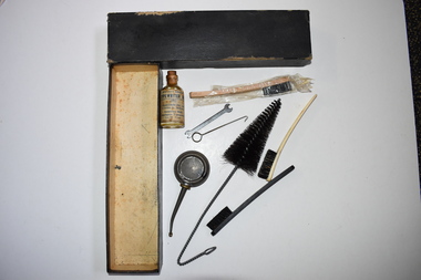
 Warrnambool and District Historical Society Inc.
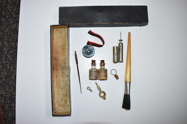
Typewriter accessories, Early 20th century
This box contains typewriter equipment for a Remington typewriter. The Remington company was founded in U.S.A. and it produced the first typewriter for commercial use in 1873. In 1886 the Remington family business was sold but the name was retained and typewriters with the Remington Rand brand name were sold from 1927 on. Typewriters have now been replaced by computers. This box of equipment belonged to Dr Horace Holmes who would have used a typewriter in his medical practice in Warrnambool in the first half of the 20th century and perhaps would also have used a typewriter in the activities of the many community groups with which he was associated. Horace Iles Holmes (1877-1959) was born and educated in Tasmania and completed a medical degree at the University of Melbourne. He commenced a practice at Warrnambool in 1906 and was the honorary Medical Officer at the Warrnambool Hospital and Warrnambool’s Health Officer. His practice was at ‘Ierne’, at the corner of Spence and Kepler Streets. He was an early member of the Royal Australian College of Surgeons and was prominent in community affairs (foundation President of the Warrnambool Rotary Club, a member of the Warrnambool Masonic Lodge for over 50 years, a Warrnambool Hospital Committee member, a long-term Trustee of the Warrnambool Methodist Church and President of the Lyndoch Hostel for the Aged Committee. Dr Holmes also had agricultural interests and enjoyed fishing, bowls and golf. This box of typewriter equipment is of interest as an item in the collection of Horace Iles Holmes, a doctor who was prominently associated with the professional and community life of Warrnambool for over 50 years. This is a rectangular-shaped black cardboard box with the name ‘Remington’ on it. It is heavily stained inside. The box contains nine objects, most identified as relevant to typewriter maintenance and cleaning:- a paint brush with a wooden handle and bristles – perhaps used for dusting the typewriter keys, two glass bottles which once contained typewriter oil but which are now empty, a red and black typewriter ribbon in a metal container, another metal container with a plunge mechanism for ejecting oil, a metal stick with a sharp end, possibly for cleaning the typewriter keys and three other unidentified small metal objects.Remingtonremington, typewriters, office equipment, dr horace holmes, warrnambool, warrnambool history, typewriter accessories -
 City of Moorabbin Historical Society (Operating the Box Cottage Museum)
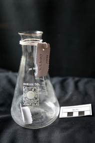
Manufactured Glass, Pharmacy beaker, c1950
Otto Schott, a chemist and glass engineer, had the vision of uniform production ie making glass items that would resemble one another. At the end of the eighteenth century, with most glass items still created by hand, the quality of output was still a guessing game. Schott was the first to render this an industrial certainty. 1884 Otto Schott, Ernst Abbe and Carl and Roderich Zeiss found the Schott & Associates Glass Technology Laboratory in Jena, Germany. Glastechnisches Laboratorium Schott & Gen was born. Production started in 1886. Original products included optical and thermometer glasses. The following year, a crucial discovery was made: borosilicate, a heat and chemically resistant glass. By it’s 25th year anniversary, the company had grown from an experimental glass factory into an internationally renowned manufacturer of optical and industrial glasses. Soon to be added was fiolax, tube-shaped glass used for vials, ampoules and syringes thus allowing the company to play a significant role in supplying Europe's nascent pharmaceutical industry. Post WW2 USA Army opens new factory in Mainz, West Germany and factory in Jena , East Germany taken over by the DDR State both using same trade name. Legal action for 30 years resolved in 1980 - split name. Berlin Wall 1989, Factories reunited 1991A pharmaceutical clear glass beaker with graduation 100ml -300ml DURAN 50Front : DURAN 50 / SCHOTT & GEN / MAINZ / JENA (ER) GLAS 300 Back : PYREX 300pharmacy, medications, medicines, glass manufacturing, glass works, early settlers, moorabbin, bentleigh, cheltenham, jenaer glaswerk schott & gen company, west germany, east germany, berlin wall, ww2 1939-45, schott otto, zeiss roderich -
 Orbost & District Historical Society
black and white photograph, July 1922
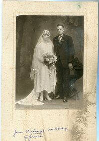
Jean Stirling , born 1901 in Orbost, married Charles Frances Reginald Joyes on 15th July 1922 in Orbost. Jean's father was John Stirling, son of James Stirling and Ann Gray. Her mother was Robina Harvey McNair, Aged 19 James Stirling arrived in Melbourne on January 26, 1842 with his family - parents, three sisters and two brothers. James Stirling moved around a lot to Whittlesea, Ballarat goldfields, Cunninghame, (now Lakes Entrance), then to the Old Station about 36 miles to the east along the coast near the mouth of the Snowy River and for a time settled there with his wife also from Wigton, Scotland, and their family four sons two daughters (James, John, William, George, Margaret and Polly). The first settler to occupy the Marlo township area was James Stirling around the year 1875. He built a bark hut on the bluff that had two rooms, bark walls, earthen floors and a shingle roof. By 1884, this structure had expanded to a 9 roomed accommodation house and in 1886 became the Marlo Hotel when a liquor license was granted. (more information from “Snowy River Mail”, Wednesday, April 13th 1977: MEMORIES OF MARLO by Mrs Elsbeth Conlon (nee Stirling )This photograph is associated with the Stirling family early settlers of Marlo. It is also a pictorial record of styles of wedding dress popular in the 1920s.A black / white studio portrait / photograph of a bridal couple. The bride on the left is wearing a typical 1920s wedding dress. tTe front is short with a hem that is in different length in front than behind. She is wearing a hat in the cloche-style. She is holding a bouquet of flowers and her train is draped to the left. The groom is wearing a three piece morning suit. he has a with a wingtip collar white dress shirt and a cravat tie.on front - hand - written "Jean Stirling's wedding (Marlo) ? Joyce"stirling-jean-wedding melba-&co wedding-clothing-1920s joyes-charles-francis-reginald -
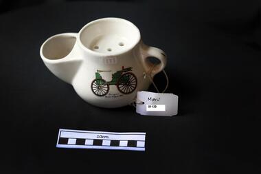 City of Moorabbin Historical Society (Operating the Box Cottage Museum)
Personal Effects, china shaving mug / scuttle, c1950
Shaving soap scuttles are distinguished from shaving mugs by having a separate area for hot water. The hot water is for dipping a shaving brush into to make a lather with the soap which is then applied to the skin before using the razor. Vintage scuttles are often elaborately decorated. Between 1880 and 1920 is the original time period for the occupational shaving mug. Most men owned a shaving mug, either at home or at a barber shop. Mugs purchased for home use typically were purchased through local stores, had more variety in style but usually went without a name. Barber shops sold mugs with the owners’ names on them partly because they thought that shaving rash came from sharing the same soap. In reality, the rash was not a result of soap but of unsterilized razors. Transfer ; The Duryea Motor Wagon was among the first standardized automobiles and among the first powered by gasoline. Fifteen examples were built by the Duryea Motor Wagon Company of Chicopee, Massachusetts, between 1893 and 1896. Their enterprise followed the first commercially available automobile which was patented by Karl Benz on January 29, 1886, and put into production in 1888. The Duryea Motor Wagon remained in production until 1917. The Duryea brothers entered their horseless carriage in many shows and races. A china shaving mug / scuttle with a car transfer. The mug has a wide spout to hold / insert the shaving brush , a perforated tray opening at the top to hold the soap and a bulbous base for the hot water. car transfershaving equipment, safety razors, cheltenham, early settlers, moorabbin, shaving soap sticks, shaving brushes, shaving scuttles, shaving rash, infectious diseases, barber shops, -
 Westbourne Grammar Heritage Collection
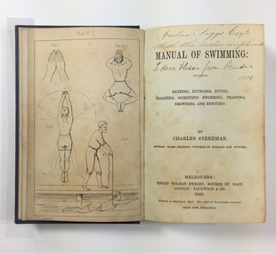
Book - Charles Steedman, 1867, Manual of Swimming
Charles Steedman was headmaster of Williamstown Grammar School from 1870-76 and 1885-90. In 1870, under agreement with school trustees, Sir George Verdon and John Courtis, he leased the school under a seven-year lease, effectively saving it from closure. Steedman had previously been manager of Sandridge Baths and a champion swimmer of Victoria. His 1867 book, 'Manual of Swimming', was the first major technical contribution to the sport of speed swimming and water safety, for which Steedman was inducted into the Sport Australia Hall of Fame in 2006. As headmaster of Williamstown Grammar, Steedman initiated a student produced school paper called 'The Schoolboy' (surviving editions can be accessed at the State Library of Victoria), added swimming lessons to the curriculum and opened enrolment to girls in 1885. The book contains nine illustration plates featuring line drawings of a human figure in the positions detailed by Steedman in his text. These drawings are attributed to O.R. Campbell. Oswald Rose Campbell is best known for his appointment (1876-1886) as drawing master of the School of Design, a department of the Public Library, Museums and National Gallery of Victoria. He taught (and famously disagreed with) the likes of celebrated Australian artists, Tom Roberts and Frederick McCubbin. O.R Campbell taught drawing and painting at Williamstown Grammar in the early 1870s.The book holds historic significance for Westbourne Grammar School, having been written by a former headmaster and very important figure in the history of the school. It evokes our early history as an emerging grammar school with links to prominent athletes, artists and gentry of colonial Melbourne. Blue cloth covered case-bound book, with debossed decorative scrollwork in each corner and in the centre of front cover, and gilt lettering on the spine. 270 numbered pages, nine illustration plates (one adjacent to title page, eight as end pages).On title page, handwritten inscriptions in brown coloured ink. Possibly ‘Joshua Saggs Esq. / With the authors compliments’ and below, in different handwriting and darker ink, ‘To dear Flossie from Grandma 1901’. williamstown, sandridge baths, swimming, colonial melbourne, art, williamstown grammar -
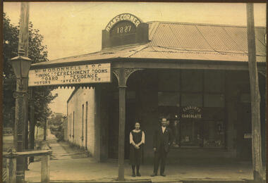 Bacchus Marsh & District Historical Society
Photograph, Ryan's Corner Shop and Refreshment Rooms. 1923
This building on the corner of Main and Gell Streets, comprised of two shops, a residence and sheds at the back, was built by Jeremiah Ryan in 1886-7. It became known as "Ryan's Corner". The first usage as mentioned in the Bacchus Marsh Express was as a jewellery in one shop and a fish and oyster shop combined with Watson's agency business in the other. Over the years, a variety of businesses operated in the two shops, including a barber shop, auctioneer and land agent premises, a hairdresser, solicitor's, costumiere, and bootmaker. Joseph Burbidge operated a greengrocery on this site for several years until the corner store was purchased in 1903 and became an ABC Cafe. Various businesses continued to operate on the site, with the neighbouring ABC cafe continuing in business with a number of different proprietors. The cafe was taken over by Miss Mary O'Donnell in 1922, assisted by Mr "Bill" Day, who became a business partner in 1924. In 1935, Miss O'Donnell sold her share of the business to Mr Day, who continued to operate the tea rooms with his wife. He remained the sole proprietor until his death in 1963. Because he was a well-known shop-keeper in the town over a period of forty years, his establishment became known locally as "Bill Day's Corner". In 1968 the building was demolished for the Commonwealth Bank, which continues to operate on this site.Black and white photograph mounted on brown cardboard. Photograph of M. O'Donnell A.B.C. Refreshment Rooms with a young woman and a gentleman standing outside on the footpath. They can be identified as Virgie McCusker and W.J "Bill" Day. The corner brick building has a corrugated iron roof with a verandah supported by pillars featuring wrought iron corners. The corner pediment bears the name : Ryan's Corner 1887. The space between the corner pillars has a large sign reading: Miss M. O'Donnell. A.B.C. Dining & Refreshment Rooms. Board & Residence. Motors Catered For. The front window has an advertising sign: Cadbury's Chocolate. A sign on the door reads: Luncheon Please. Items can be seen in the window. At the corner stands an ornate iron gas lamppost.On the back: Handwritten: Corner Main & Gell Sts built by Jeremiah Ryan 1)Day. demolishe 19 (incomplete date) Site now Commonwealth Bank. C.B.A. opened 1963. Virgie McCusker, niece of Miss O'Donnell. 21/3/23.shops bacchus marsh, small businesses bacchus marsh, refreshment rooms, w.j. "bill" day 1887-1963 -
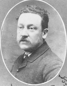 Ringwood and District Historical Society
Photograph, James Handforth, father of Katherine, wife of Louis Herry, formerly of Walhalla and Cheshire, England. c1880
Black and white photographWritten on backing sheet, "James Handforth, father of Katherine, wife of Louis Herry, formerly of Walhalla and Cheshire, England". From the Place of Many Eagles book, "Louis was born in Purdu, France, in 1855, and came to Ringwood from Walhalla in 1887 and erected a weatherboard house and shop opposite the Club Hotel, using a Miner's Right to secure the land. When he arrived, Louis was a married man with three children, Leopold (1882), Marie (1884), John (1886). He had married Kate Handforth at Walhalla in 1879. In later years Elizabeth, Minellia, Louis and Denise were born. Kate's father was known as the midwife of the Gippsiand township because he had once been a fourth year medical student in England, but earnt a living as a goldbuyer in Victoria. Marie Herry would grow up remembering her grandfather calling sometimes at Ringwood; he would bring the children jubilee Mixture to eat and he carried a revolver in his pocket. Often he would play the violin while Marie would stepdance on the kitchen table." -
 Warrnambool and District Historical Society Inc.
Typewriter maintenance kit, Early 20th century
This box contains maintenance equipment for a Remington typewriter. The Remington company was founded in U.S.A. and it produced the world’s first typewriter for commercial use in 1873. In 1886 the Remington family business was sold but the name was retained and typewriters with the Remington Rand brand name were sold from 1927 on. Typewriters have now been replaced by computers. This box of equipment belonged to Dr Horace Holmes who would have used a typewriter in his medical practice in Warrnambool in the first half of the 20th century and perhaps would also have used a typewriter in the activities of the many community groups with which he was associated. Horace Iles Holmes (1877-1959) was born and educated in Tasmania and he completed a medical degree at the University of Melbourne. He commenced a practice in Warrnambool in 1906 and was the honorary Medical Officer at the Warrnambool Hospital and Warrnambool’s Health Officer. His practice was at ‘Ierne’ at the corner of Spence and Kepler Streets. He was an early member of the Royal Australian College of Surgeons and was prominent in community affairs (foundation President of Warrnambool Rotary Club, a member of the Warrnambool Masonic Lodge for over 50 years, a Warrnambool Hospital Committee member, a long-term Trustee of the Warrnambool Methodist Church and President of the Lyndoch Hostel for the Aged Committee. Dr Holmes also had agricultural interests and enjoyed fishing, bowls and golf. This box of typewriter equipment is of interest as an item in the collection of Horace Iles Holmes, a doctor who was prominently associated with the professional and community life of Warrnambool for over 50 years. This is a rectangular-shaped black cardboard box with a detachable lid. The box contains eight items used for typewriter maintenance. They are a glass bottle containing typewriter oil, a round metal oil dispenser, a small metal hook, a small metal spanner, a metal wire brush, and three bristle brushes, one with a bone handle and one with a wooden handle enclosed in cellophane. The box is somewhat stained inside. On a brush: ‘Made in U.S.A. bristle’ On the glass bottle: ‘Specially refined typewriter oil, Chartres Pty Ltd 375 Collins St. Melbourne Australian Built Remington Typewriters Phone 9100 (8 lines)’ typewriters, remington, dr horace holmes, warrnambool, history of warrnambool, office equipment -
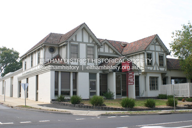 Eltham District Historical Society Inc
Photograph - Digital Photograph, Alan King, Eltham Hotel, cnr Main Road and Pitt Street, 28 December 2007
The Eltham Hotel is the oldest continually operating hotel in the Eltham district. Initially referred to as the Little Eltham Hotel, it has been known as the Eltham Hotel since the mid-1850s through to the present except for a brief period as the Eltham Tavern in the late 1980s. The original hotel opened in 1854 by Richard Warren was built by Benjamin Oliver Wallis. The Fountain of Friendship Hotel on the opposite side of Maria Street (Main Road) opened shortly after. The hotel was a well-known resting place for gold diggers during the gold rush at Woods’ Point and Warren would buy the gold from the diggers. Warren ran into financial difficulties and determined to return to England. Wallis bought the hotel in 1861 and ran it till 1886 when he sold it to Christopher Watson Snr. When Christopher Watson Snr died a year after purchase, his son Christopher took over until his death in 1909 when it passed to wife Emily and then their youngest son, Herbert James (Jim) Watson in 1915. In July 1925, Jim Watson demolished the original building and, in its place, erected a modern hotel which remains the foundation of the present-day Eltham Hotel. Covered under Heritage Overlay, Nillumbik Planning Scheme. Published: Nillumbik Now and Then / Marguerite Marshall 2008; photographs Alan King with Marguerite Marshall.; p41This collection of almost 130 photos about places and people within the Shire of Nillumbik, an urban and rural municipality in Melbourne's north, contributes to an understanding of the history of the Shire. Published in 2008 immediately prior to the Black Saturday bushfires of February 7, 2009, it documents sites that were impacted, and in some cases destroyed by the fires. It includes photographs taken especially for the publication, creating a unique time capsule representing the Shire in the early 21st century. It remains the most recent comprehenesive publication devoted to the Shire's history connecting local residents to the past. nillumbik now and then (marshall-king) collection, eltham, eltham hotel, main road, pitt street -
 Eltham District Historical Society Inc
Photograph, Liz Pidgeon, Heritage Excursion; Maroondah Aqueduct, 3 September 2016, 3 September 2016
Newsletter No., 229, August 2016 Heritage Excursion - Maroondah Aqueduct Walk - Saturday 3rd September The Maroondah Aqueduct was once a major link in Melbourne’s water supply system. It was built between 1886 and 1891 to transfer water from the Watts River near Healesville to the Preston Reservoir. It was 66 km in length, made up of 41 km of open channel, 10 km of tunnel through hills and 15 km of pipeline across stream valleys known as inverted siphons. The section of the aqueduct through the Eltham area has been abandoned since the 1980s but the open channel has largely been retained. A recreational path follows the aqueduct reserve. For our excursion on 3rd September we intend to walk along the section of the aqueduct adjacent to Allendale Road. This is a section not visited on previous excursions and includes the transition from open channel to the inverted siphon across the Diamond Creek valley. Apart from the aqueduct itself the main feature of the walk is the extensive views across Eltham North and Diamond Creek. Along the way we will talk about the history of the aqueduct and the area. This easy walk is about 3 km return and will take 2 to 2.5 hours. It will start at 2pm at the junction of Allendale Road with Godber Road and Zig Zag Road North, officially Diamond Creek, but on the northern boundary of Eltham. (Melway ref.12 B10). Born Digitalmaroondah aqueduct, eltham north, activities, eltham district historical society, heritage excursion, acqueduct trail, sign -
 Eltham District Historical Society Inc
Photograph, Liz Pidgeon, Heritage Excursion; Maroondah Aqueduct, 3 September 2016, 3 September 2016
Newsletter No., 229, August 2016 Heritage Excursion - Maroondah Aqueduct Walk - Saturday 3rd September The Maroondah Aqueduct was once a major link in Melbourne’s water supply system. It was built between 1886 and 1891 to transfer water from the Watts River near Healesville to the Preston Reservoir. It was 66 km in length, made up of 41 km of open channel, 10 km of tunnel through hills and 15 km of pipeline across stream valleys known as inverted siphons. The section of the aqueduct through the Eltham area has been abandoned since the 1980s but the open channel has largely been retained. A recreational path follows the aqueduct reserve. For our excursion on 3rd September we intend to walk along the section of the aqueduct adjacent to Allendale Road. This is a section not visited on previous excursions and includes the transition from open channel to the inverted siphon across the Diamond Creek valley. Apart from the aqueduct itself the main feature of the walk is the extensive views across Eltham North and Diamond Creek. Along the way we will talk about the history of the aqueduct and the area. This easy walk is about 3 km return and will take 2 to 2.5 hours. It will start at 2pm at the junction of Allendale Road with Godber Road and Zig Zag Road North, officially Diamond Creek, but on the northern boundary of Eltham. (Melway ref.12 B10). Born Digitalmaroondah aqueduct, eltham north, activities, eltham district historical society, heritage excursion, acqueduct trail, diamond creek -
 Eltham District Historical Society Inc
Photograph, Liz Pidgeon, Heritage Excursion; Maroondah Aqueduct, 3 September 2016, 3 September 2016
Newsletter No., 229, August 2016 Heritage Excursion - Maroondah Aqueduct Walk - Saturday 3rd September The Maroondah Aqueduct was once a major link in Melbourne’s water supply system. It was built between 1886 and 1891 to transfer water from the Watts River near Healesville to the Preston Reservoir. It was 66 km in length, made up of 41 km of open channel, 10 km of tunnel through hills and 15 km of pipeline across stream valleys known as inverted siphons. The section of the aqueduct through the Eltham area has been abandoned since the 1980s but the open channel has largely been retained. A recreational path follows the aqueduct reserve. For our excursion on 3rd September we intend to walk along the section of the aqueduct adjacent to Allendale Road. This is a section not visited on previous excursions and includes the transition from open channel to the inverted siphon across the Diamond Creek valley. Apart from the aqueduct itself the main feature of the walk is the extensive views across Eltham North and Diamond Creek. Along the way we will talk about the history of the aqueduct and the area. This easy walk is about 3 km return and will take 2 to 2.5 hours. It will start at 2pm at the junction of Allendale Road with Godber Road and Zig Zag Road North, officially Diamond Creek, but on the northern boundary of Eltham. (Melway ref.12 B10). Born Digitalmaroondah aqueduct, eltham north, activities, eltham district historical society, heritage excursion, acqueduct trail, sign -
 Eltham District Historical Society Inc
Photograph, Liz Pidgeon, Heritage Excursion; Maroondah Aqueduct, 3 September 2016, 3 September 2016
Newsletter No., 229, August 2016 Heritage Excursion - Maroondah Aqueduct Walk - Saturday 3rd September The Maroondah Aqueduct was once a major link in Melbourne’s water supply system. It was built between 1886 and 1891 to transfer water from the Watts River near Healesville to the Preston Reservoir. It was 66 km in length, made up of 41 km of open channel, 10 km of tunnel through hills and 15 km of pipeline across stream valleys known as inverted siphons. The section of the aqueduct through the Eltham area has been abandoned since the 1980s but the open channel has largely been retained. A recreational path follows the aqueduct reserve. For our excursion on 3rd September we intend to walk along the section of the aqueduct adjacent to Allendale Road. This is a section not visited on previous excursions and includes the transition from open channel to the inverted siphon across the Diamond Creek valley. Apart from the aqueduct itself the main feature of the walk is the extensive views across Eltham North and Diamond Creek. Along the way we will talk about the history of the aqueduct and the area. This easy walk is about 3 km return and will take 2 to 2.5 hours. It will start at 2pm at the junction of Allendale Road with Godber Road and Zig Zag Road North, officially Diamond Creek, but on the northern boundary of Eltham. (Melway ref.12 B10). Born Digitalmaroondah aqueduct, eltham north, activities, eltham district historical society, heritage excursion, acqueduct trail -
 Eltham District Historical Society Inc
Photograph, Liz Pidgeon, Heritage Excursion; Maroondah Aqueduct, 3 September 2016, 3 September 2016
Intersection with local Street signs Newsletter No., 229, August 2016 Heritage Excursion - Maroondah Aqueduct Walk - Saturday 3rd September The Maroondah Aqueduct was once a major link in Melbourne’s water supply system. It was built between 1886 and 1891 to transfer water from the Watts River near Healesville to the Preston Reservoir. It was 66 km in length, made up of 41 km of open channel, 10 km of tunnel through hills and 15 km of pipeline across stream valleys known as inverted siphons. The section of the aqueduct through the Eltham area has been abandoned since the 1980s but the open channel has largely been retained. A recreational path follows the aqueduct reserve. For our excursion on 3rd September we intend to walk along the section of the aqueduct adjacent to Allendale Road. This is a section not visited on previous excursions and includes the transition from open channel to the inverted siphon across the Diamond Creek valley. Apart from the aqueduct itself the main feature of the walk is the extensive views across Eltham North and Diamond Creek. Along the way we will talk about the history of the aqueduct and the area. This easy walk is about 3 km return and will take 2 to 2.5 hours. It will start at 2pm at the junction of Allendale Road with Godber Road and Zig Zag Road North, officially Diamond Creek, but on the northern boundary of Eltham. (Melway ref.12 B10). Born Digitalmaroondah aqueduct, eltham north, activities, eltham district historical society, heritage excursion, street signs, acqueduct trail, allendale rd, godber rd, zig zag road, intersection -
 Eltham District Historical Society Inc
Photograph, Liz Pidgeon, Heritage Excursion; Maroondah Aqueduct, 3 September 2016, 3 September 2016
Newsletter No., 229, August 2016 Heritage Excursion - Maroondah Aqueduct Walk - Saturday 3rd September The Maroondah Aqueduct was once a major link in Melbourne’s water supply system. It was built between 1886 and 1891 to transfer water from the Watts River near Healesville to the Preston Reservoir. It was 66 km in length, made up of 41 km of open channel, 10 km of tunnel through hills and 15 km of pipeline across stream valleys known as inverted siphons. The section of the aqueduct through the Eltham area has been abandoned since the 1980s but the open channel has largely been retained. A recreational path follows the aqueduct reserve. For our excursion on 3rd September we intend to walk along the section of the aqueduct adjacent to Allendale Road. This is a section not visited on previous excursions and includes the transition from open channel to the inverted siphon across the Diamond Creek valley. Apart from the aqueduct itself the main feature of the walk is the extensive views across Eltham North and Diamond Creek. Along the way we will talk about the history of the aqueduct and the area. This easy walk is about 3 km return and will take 2 to 2.5 hours. It will start at 2pm at the junction of Allendale Road with Godber Road and Zig Zag Road North, officially Diamond Creek, but on the northern boundary of Eltham. (Melway ref.12 B10). Born Digitalmaroondah aqueduct, eltham north, activities, eltham district historical society, heritage excursion, acqueduct trail -
 Eltham District Historical Society Inc
Photograph, Liz Pidgeon, Heritage Excursion; Maroondah Aqueduct, 3 September 2016, 3 September 2016
Property related to Yarra Valley Water, Diamond Creek Newsletter No., 229, August 2016 Heritage Excursion - Maroondah Aqueduct Walk - Saturday 3rd September The Maroondah Aqueduct was once a major link in Melbourne’s water supply system. It was built between 1886 and 1891 to transfer water from the Watts River near Healesville to the Preston Reservoir. It was 66 km in length, made up of 41 km of open channel, 10 km of tunnel through hills and 15 km of pipeline across stream valleys known as inverted siphons. The section of the aqueduct through the Eltham area has been abandoned since the 1980s but the open channel has largely been retained. A recreational path follows the aqueduct reserve. For our excursion on 3rd September we intend to walk along the section of the aqueduct adjacent to Allendale Road. This is a section not visited on previous excursions and includes the transition from open channel to the inverted siphon across the Diamond Creek valley. Apart from the aqueduct itself the main feature of the walk is the extensive views across Eltham North and Diamond Creek. Along the way we will talk about the history of the aqueduct and the area. This easy walk is about 3 km return and will take 2 to 2.5 hours. It will start at 2pm at the junction of Allendale Road with Godber Road and Zig Zag Road North, officially Diamond Creek, but on the northern boundary of Eltham. (Melway ref.12 B10). Born Digitalmaroondah aqueduct, eltham north, activities, eltham district historical society, heritage excursion, yarra valley water, diamond creek -
 Eltham District Historical Society Inc
Photograph, Liz Pidgeon, Heritage Excursion; Maroondah Aqueduct, 3 September 2016, 3 September 2016
Sign for Yarra Valley Water at Diamond Creek property Newsletter No., 229, August 2016 Heritage Excursion - Maroondah Aqueduct Walk - Saturday 3rd September The Maroondah Aqueduct was once a major link in Melbourne’s water supply system. It was built between 1886 and 1891 to transfer water from the Watts River near Healesville to the Preston Reservoir. It was 66 km in length, made up of 41 km of open channel, 10 km of tunnel through hills and 15 km of pipeline across stream valleys known as inverted siphons. The section of the aqueduct through the Eltham area has been abandoned since the 1980s but the open channel has largely been retained. A recreational path follows the aqueduct reserve. For our excursion on 3rd September we intend to walk along the section of the aqueduct adjacent to Allendale Road. This is a section not visited on previous excursions and includes the transition from open channel to the inverted siphon across the Diamond Creek valley. Apart from the aqueduct itself the main feature of the walk is the extensive views across Eltham North and Diamond Creek. Along the way we will talk about the history of the aqueduct and the area. This easy walk is about 3 km return and will take 2 to 2.5 hours. It will start at 2pm at the junction of Allendale Road with Godber Road and Zig Zag Road North, officially Diamond Creek, but on the northern boundary of Eltham. (Melway ref.12 B10). Born Digitalmaroondah aqueduct, eltham north, activities, eltham district historical society, heritage excursion, diamond creek, yarra valley water, sign -
 Eltham District Historical Society Inc
Photograph, Liz Pidgeon, Heritage Excursion; Maroondah Aqueduct, 3 September 2016, 3 September 2016
Newsletter No., 229, August 2016 Heritage Excursion - Maroondah Aqueduct Walk - Saturday 3rd September The Maroondah Aqueduct was once a major link in Melbourne’s water supply system. It was built between 1886 and 1891 to transfer water from the Watts River near Healesville to the Preston Reservoir. It was 66 km in length, made up of 41 km of open channel, 10 km of tunnel through hills and 15 km of pipeline across stream valleys known as inverted siphons. The section of the aqueduct through the Eltham area has been abandoned since the 1980s but the open channel has largely been retained. A recreational path follows the aqueduct reserve. For our excursion on 3rd September we intend to walk along the section of the aqueduct adjacent to Allendale Road. This is a section not visited on previous excursions and includes the transition from open channel to the inverted siphon across the Diamond Creek valley. Apart from the aqueduct itself the main feature of the walk is the extensive views across Eltham North and Diamond Creek. Along the way we will talk about the history of the aqueduct and the area. This easy walk is about 3 km return and will take 2 to 2.5 hours. It will start at 2pm at the junction of Allendale Road with Godber Road and Zig Zag Road North, officially Diamond Creek, but on the northern boundary of Eltham. (Melway ref.12 B10). Born Digitalmaroondah aqueduct, eltham north, activities, eltham district historical society, heritage excursion, acqueduct trail -
 Eltham District Historical Society Inc
Photograph, Liz Pidgeon, Heritage Excursion; Maroondah Aqueduct, 3 September 2016, 3 September 2016
View of Diamond Creek Newsletter No., 229, August 2016 Heritage Excursion - Maroondah Aqueduct Walk - Saturday 3rd September The Maroondah Aqueduct was once a major link in Melbourne’s water supply system. It was built between 1886 and 1891 to transfer water from the Watts River near Healesville to the Preston Reservoir. It was 66 km in length, made up of 41 km of open channel, 10 km of tunnel through hills and 15 km of pipeline across stream valleys known as inverted siphons. The section of the aqueduct through the Eltham area has been abandoned since the 1980s but the open channel has largely been retained. A recreational path follows the aqueduct reserve. For our excursion on 3rd September we intend to walk along the section of the aqueduct adjacent to Allendale Road. This is a section not visited on previous excursions and includes the transition from open channel to the inverted siphon across the Diamond Creek valley. Apart from the aqueduct itself the main feature of the walk is the extensive views across Eltham North and Diamond Creek. Along the way we will talk about the history of the aqueduct and the area. This easy walk is about 3 km return and will take 2 to 2.5 hours. It will start at 2pm at the junction of Allendale Road with Godber Road and Zig Zag Road North, officially Diamond Creek, but on the northern boundary of Eltham. (Melway ref.12 B10). Born Digitalmaroondah aqueduct, eltham north, activities, eltham district historical society, heritage excursion, diamond creek, acqueduct trail -
 Eltham District Historical Society Inc
Photograph, Liz Pidgeon, Heritage Excursion; Maroondah Aqueduct, 3 September 2016, 3 September 2016
Russell Yeomann provides historical information on the heritage excursion From the Newsletter No., 229, August 2016 Heritage Excursion - Maroondah Aqueduct Walk - Saturday 3rd September The Maroondah Aqueduct was once a major link in Melbourne’s water supply system. It was built between 1886 and 1891 to transfer water from the Watts River near Healesville to the Preston Reservoir. It was 66 km in length, made up of 41 km of open channel, 10 km of tunnel through hills and 15 km of pipeline across stream valleys known as inverted siphons. The section of the aqueduct through the Eltham area has been abandoned since the 1980s but the open channel has largely been retained. A recreational path follows the aqueduct reserve. For our excursion on 3rd September we intend to walk along the section of the aqueduct adjacent to Allendale Road. This is a section not visited on previous excursions and includes the transition from open channel to the inverted siphon across the Diamond Creek valley. Apart from the aqueduct itself the main feature of the walk is the extensive views across Eltham North and Diamond Creek. Along the way we will talk about the history of the aqueduct and the area. This easy walk is about 3 km return and will take 2 to 2.5 hours. It will start at 2pm at the junction of Allendale Road with Godber Road and Zig Zag Road North, officially Diamond Creek, but on the northern boundary of Eltham. (Melway ref.12 B10). Born Digitalmaroondah aqueduct, eltham north, activities, eltham district historical society, heritage excursion, russell yeoman, aqueduct trail -
 Eltham District Historical Society Inc
Photograph, Liz Pidgeon, Heritage Excursion; Maroondah Aqueduct, 3 September 2016, 3 September 2016
Newsletter No., 229, August 2016 Heritage Excursion - Maroondah Aqueduct Walk - Saturday 3rd September The Maroondah Aqueduct was once a major link in Melbourne’s water supply system. It was built between 1886 and 1891 to transfer water from the Watts River near Healesville to the Preston Reservoir. It was 66 km in length, made up of 41 km of open channel, 10 km of tunnel through hills and 15 km of pipeline across stream valleys known as inverted siphons. The section of the aqueduct through the Eltham area has been abandoned since the 1980s but the open channel has largely been retained. A recreational path follows the aqueduct reserve. For our excursion on 3rd September we intend to walk along the section of the aqueduct adjacent to Allendale Road. This is a section not visited on previous excursions and includes the transition from open channel to the inverted siphon across the Diamond Creek valley. Apart from the aqueduct itself the main feature of the walk is the extensive views across Eltham North and Diamond Creek. Along the way we will talk about the history of the aqueduct and the area. This easy walk is about 3 km return and will take 2 to 2.5 hours. It will start at 2pm at the junction of Allendale Road with Godber Road and Zig Zag Road North, officially Diamond Creek, but on the northern boundary of Eltham. (Melway ref.12 B10). Born Digitalmaroondah aqueduct, eltham north, activities, eltham district historical society, heritage excursion, water-pipes, pipes, cattle yard, aqueduct trail -
 Eltham District Historical Society Inc
Photograph, Liz Pidgeon, Heritage Excursion; Maroondah Aqueduct, 3 September 2016, 3 September 2016
Newsletter No., 229, August 2016 Heritage Excursion - Maroondah Aqueduct Walk - Saturday 3rd September The Maroondah Aqueduct was once a major link in Melbourne’s water supply system. It was built between 1886 and 1891 to transfer water from the Watts River near Healesville to the Preston Reservoir. It was 66 km in length, made up of 41 km of open channel, 10 km of tunnel through hills and 15 km of pipeline across stream valleys known as inverted siphons. The section of the aqueduct through the Eltham area has been abandoned since the 1980s but the open channel has largely been retained. A recreational path follows the aqueduct reserve. For our excursion on 3rd September we intend to walk along the section of the aqueduct adjacent to Allendale Road. This is a section not visited on previous excursions and includes the transition from open channel to the inverted siphon across the Diamond Creek valley. Apart from the aqueduct itself the main feature of the walk is the extensive views across Eltham North and Diamond Creek. Along the way we will talk about the history of the aqueduct and the area. This easy walk is about 3 km return and will take 2 to 2.5 hours. It will start at 2pm at the junction of Allendale Road with Godber Road and Zig Zag Road North, officially Diamond Creek, but on the northern boundary of Eltham. (Melway ref.12 B10). Born Digitalmaroondah aqueduct, eltham north, activities, eltham district historical society, heritage excursion, aqueduct trail, cattle yard -
 Eltham District Historical Society Inc
Photograph, Liz Pidgeon, Heritage Excursion; Maroondah Aqueduct, 3 September 2016, 3 September 2016
Newsletter No., 229, August 2016 Heritage Excursion - Maroondah Aqueduct Walk - Saturday 3rd September The Maroondah Aqueduct was once a major link in Melbourne’s water supply system. It was built between 1886 and 1891 to transfer water from the Watts River near Healesville to the Preston Reservoir. It was 66 km in length, made up of 41 km of open channel, 10 km of tunnel through hills and 15 km of pipeline across stream valleys known as inverted siphons. The section of the aqueduct through the Eltham area has been abandoned since the 1980s but the open channel has largely been retained. A recreational path follows the aqueduct reserve. For our excursion on 3rd September we intend to walk along the section of the aqueduct adjacent to Allendale Road. This is a section not visited on previous excursions and includes the transition from open channel to the inverted siphon across the Diamond Creek valley. Apart from the aqueduct itself the main feature of the walk is the extensive views across Eltham North and Diamond Creek. Along the way we will talk about the history of the aqueduct and the area. This easy walk is about 3 km return and will take 2 to 2.5 hours. It will start at 2pm at the junction of Allendale Road with Godber Road and Zig Zag Road North, officially Diamond Creek, but on the northern boundary of Eltham. (Melway ref.12 B10). Born Digitalmaroondah aqueduct, eltham north, activities, eltham district historical society, heritage excursion, aqueduct trail, water-pipe, pipe -
 Eltham District Historical Society Inc
Photograph, Liz Pidgeon, Heritage Excursion; Maroondah Aqueduct, 3 September 2016, 3 September 2016
Newsletter No., 229, August 2016 Heritage Excursion - Maroondah Aqueduct Walk - Saturday 3rd September The Maroondah Aqueduct was once a major link in Melbourne’s water supply system. It was built between 1886 and 1891 to transfer water from the Watts River near Healesville to the Preston Reservoir. It was 66 km in length, made up of 41 km of open channel, 10 km of tunnel through hills and 15 km of pipeline across stream valleys known as inverted siphons. The section of the aqueduct through the Eltham area has been abandoned since the 1980s but the open channel has largely been retained. A recreational path follows the aqueduct reserve. For our excursion on 3rd September we intend to walk along the section of the aqueduct adjacent to Allendale Road. This is a section not visited on previous excursions and includes the transition from open channel to the inverted siphon across the Diamond Creek valley. Apart from the aqueduct itself the main feature of the walk is the extensive views across Eltham North and Diamond Creek. Along the way we will talk about the history of the aqueduct and the area. This easy walk is about 3 km return and will take 2 to 2.5 hours. It will start at 2pm at the junction of Allendale Road with Godber Road and Zig Zag Road North, officially Diamond Creek, but on the northern boundary of Eltham. (Melway ref.12 B10). Born Digitalmaroondah aqueduct, eltham north, activities, eltham district historical society, heritage excursion, aqueduct trail, cattle yards