Showing 8372 items matching "bridges"
-
 Kew Historical Society Inc
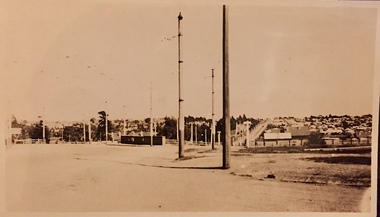
Photograph - High Street, Kew East
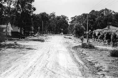
In 1980, Mr Laurie Bennett presented the Kew Historical Society with a number of photographs and postcards from the estate of his mother Eileen Mary Bennett (nee Clark). His mother was the daughter of Lawrence FH Clark(?-1946) and Mary Clark (?-1925) of 22 Harp Road, East Kew, in whose yard the photograph was taken. A year before the donation occurred a notice appeared in the Canberra Times stating that: "BENNETT, Eileen Mary. — May 8th at Tuross Heads, N.S.W. Late of 22 Harp Rd, East Kew, (Vic). Dearly loved wife of the late Harold Bennett, loved mother and mother in law of Laurie and Shirley (Melbourne), Kevin and Doreen (Canberra), grandmother of Linda, Stephen, Paul, Gabrielle, Peter, Mark and Jon."Part of a large collection of photographs and postcards in the collection. This dated photograph allows the researcher to identify development by 1916 in Kew and East Kew.High Street, Kew East in 1916 looking west. "High Street, East kew, near rail bridge."laurie bennett, eileen mary bennett, eileen mary clark -
 Stawell Historical Society Inc
Book, The Threshold of Life, 1889
Campbells Bridge Presbyterian Sunday School. To Robert Traskstawell education religion -
 Stawell Historical Society Inc
Book, Jesse Page, Amid Greenland Snows, 1893
To Albert Trask by Presbyterian Sabbath School Campbells Bridgestawell education religion -
 Stawell Historical Society Inc
Book, A.L.O.E, The Blacksmith of Boniface Lane, 1892
Campbells Bridge Presbyterian Sunday School. To Robert Traskstawell education religion -
 Stawell Historical Society Inc
Book, Maud Jean Franc, Minnie’s Mission, 1889
Campbells Bridge Presbyterian Sunday School. To Martha Traskstawell education religion -
 Marysville & District Historical Society
Photograph (Item) - Black and white photograph, 1954
A black and white photograph taken at the Fruit Salad Farm in Marysville in 1954.A black and white photograph taken at the Fruit Salad Farm in Marysville in 1954.Rosalie - 1954/ Marysville Fruit Salad Farm Bridgemarysville, victoria, australia, fruit salad farm, accommodation, restaurant, photograph -
![Photograph - Construction of the F19 [Eastern Freeway], Ron Setford, May 1976](/media/collectors/550653872162f11fb04854aa/items/6815afa28b33318343789e1c/item-media/6815afc88b33318343789fc9/item-fit-380x285.jpg) Kew Historical Society Inc
Kew Historical Society IncPhotograph - Construction of the F19 [Eastern Freeway], Ron Setford, May 1976
Ron Setford and his wife Grace Setford lived in Tanner Avenue, East Kew, from c.1946 to c.1995. A keen photographer, he recorded the changing face of Kew over a 20 year period. Apart from 30 photographs of built structures and places in Kew dating from 1960 and 1961, 145 of his 35mm colour slides chronicle the development of the F19 (later renamed Eastern) Freeway through the Yarra Valley in Kew over a five year period from c.1972 to c.1977. This important collection was donated to the Society by his granddaughter in 2025.This collection of 175 35mm slides is of local and statewide significance, owing to its subject matter, particularly the major development of road transport infrastructure during the 1970s with the construction of the Eastern Freeway. The photographer also took care to annotate and date most of his slides which enable the researcher to pinpoint temporal and spatial locations."Main bridges over Yarra River / Kew - Fairfield"ron setford, eastern freeway, f19 freeway -
![Photograph - Construction of the F19 [Eastern Freeway], Ron Setford, May 1976](/media/collectors/550653872162f11fb04854aa/items/6828851364071e7c58e697c5/item-media/6828853364071e7c58e69987/item-fit-380x285.jpg) Kew Historical Society Inc
Kew Historical Society IncPhotograph - Construction of the F19 [Eastern Freeway], Ron Setford, May 1976
Ron Setford and his wife Grace Setford lived in Tanner Avenue, East Kew, from c.1946 to c.1995. A keen photographer, he recorded the changing face of Kew over a 20 year period. Apart from 30 photographs of built structures and places in Kew dating from 1960 and 1961, 145 of his 35mm colour slides chronicle the development of the F19 (later renamed Eastern) Freeway through the Yarra Valley in Kew over a five year period from c.1972 to c.1977. This important collection was donated to the Society by his granddaughter in 2025.This collection of 175 35mm slides is of local and statewide significance, owing to its subject matter, particularly the major development of road transport infrastructure during the 1970s with the construction of the Eastern Freeway. The photographer also took care to annotate and date most of his slides which enable the researcher to pinpoint temporal and spatial locations."Freeway bank conservaion near Belford Rd Bridge"ron setford, eastern freeway, f19 freeway -
![Photograph - Construction of the F19 [Eastern Freeway], Ron Setford, August 1973](/media/collectors/550653872162f11fb04854aa/items/6808c302025de50d1e73108d/item-media/6808c31e025de50d1e7312ad/item-fit-380x285.jpg) Kew Historical Society Inc
Kew Historical Society IncPhotograph - Construction of the F19 [Eastern Freeway], Ron Setford, August 1973
Ron Setford and his wife Grace Setford lived in Tanner Avenue, East Kew, from c.1946 to c.1995. A keen photographer, he recorded the changing face of Kew over a 20 year period. Apart from 30 photographs of built structures and places in Kew dating from 1960 and 1961, 145 of his 35mm colour slides chronicle the development of the F19 (later renamed Eastern) Freeway through the Yarra Valley in Kew over a five year period from c.1972 to c.1977. This important collection was donated to the Society by his granddaughter in 2025.This collection of 175 35mm slides is of local and statewide significance, owing to its subject matter, particularly the major development of road transport infrastructure during the 1970s with the construction of the Eastern Freeway. The photographer also took care to annotate and date most of his slides which enable the researcher to pinpoint temporal and spatial locations."Eastern Freeway / Belford Rd Bridge / August 73"ron setford, eastern freeway, f19 freeway -
![Photograph - Construction of the F19 [Eastern Freeway], Ron Setford, May 1974](/media/collectors/550653872162f11fb04854aa/items/6831c9f7675df5c02f042c18/item-media/6831ca10675df5c02f042c6e/item-fit-380x285.jpg) Kew Historical Society Inc
Kew Historical Society IncPhotograph - Construction of the F19 [Eastern Freeway], Ron Setford, May 1974
Ron Setford and his wife Grace Setford lived in Tanner Avenue, East Kew, from c.1946 to c.1995. A keen photographer, he recorded the changing face of Kew over a 20 year period. Apart from 30 photographs of built structures and places in Kew dating from 1960 and 1961, 145 of his 35mm colour slides chronicle the development of the F19 (later renamed Eastern) Freeway through the Yarra Valley in Kew over a five year period from c.1972 to c.1977. This important collection was donated to the Society by his granddaughter in 2025.This collection of 175 35mm slides is of local and statewide significance, owing to its subject matter, particularly the major development of road transport infrastructure during the 1970s with the construction of the Eastern Freeway. The photographer also took care to annotate and date most of his slides which enable the researcher to pinpoint temporal and spatial locations."New Chandler H/way Bridge / May 74"ron setford, eastern freeway, f19 freeway -
![Photograph - Construction of the F19 [Eastern Freeway], Ron Setford, October 1976](/media/collectors/550653872162f11fb04854aa/items/682afcd6b92b884efed2688f/item-media/682aff26b92b884efed26ad9/item-fit-380x285.jpg) Kew Historical Society Inc
Kew Historical Society IncPhotograph - Construction of the F19 [Eastern Freeway], Ron Setford, October 1976
Ron Setford and his wife Grace Setford lived in Tanner Avenue, East Kew, from c.1946 to c.1995. A keen photographer, he recorded the changing face of Kew over a 20 year period. Apart from 30 photographs of built structures and places in Kew dating from 1960 and 1961, 145 of his 35mm colour slides chronicle the development of the F19 (later renamed Eastern) Freeway through the Yarra Valley in Kew over a five year period from c.1972 to c.1977. This important collection was donated to the Society by his granddaughter in 2025.This collection of 175 35mm slides is of local and statewide significance, owing to its subject matter, particularly the major development of road transport infrastructure during the 1970s with the construction of the Eastern Freeway. The photographer also took care to annotate and date most of his slides which enable the researcher to pinpoint temporal and spatial locations."Pylons are modelled / F/way bridge over Yarra"ron setford, eastern freeway, f19 freeway -
![Photograph - Construction of the F19 [Eastern Freeway], Ron Setford, January 1975](/media/collectors/550653872162f11fb04854aa/items/682c49995014d0f6bed6a915/item-media/682c49c05014d0f6bed6aae7/item-fit-380x285.jpg) Kew Historical Society Inc
Kew Historical Society IncPhotograph - Construction of the F19 [Eastern Freeway], Ron Setford, January 1975
Ron Setford and his wife Grace Setford lived in Tanner Avenue, East Kew, from c.1946 to c.1995. A keen photographer, he recorded the changing face of Kew over a 20 year period. Apart from 30 photographs of built structures and places in Kew dating from 1960 and 1961, 145 of his 35mm colour slides chronicle the development of the F19 (later renamed Eastern) Freeway through the Yarra Valley in Kew over a five year period from c.1972 to c.1977. This important collection was donated to the Society by his granddaughter in 2025.This collection of 175 35mm slides is of local and statewide significance, owing to its subject matter, particularly the major development of road transport infrastructure during the 1970s with the construction of the Eastern Freeway. The photographer also took care to annotate and date most of his slides which enable the researcher to pinpoint temporal and spatial locations."Eastern Freeway / New Belford Bridge / 1/75"ron setford, eastern freeway, f19 freeway -
![Photograph - Construction of the F19 [Eastern Freeway], Ron Setford, May 1974](/media/collectors/550653872162f11fb04854aa/items/682c4a125014d0f6bed6abc8/item-media/682c4a365014d0f6bed6ad92/item-fit-380x285.jpg) Kew Historical Society Inc
Kew Historical Society IncPhotograph - Construction of the F19 [Eastern Freeway], Ron Setford, May 1974
Ron Setford and his wife Grace Setford lived in Tanner Avenue, East Kew, from c.1946 to c.1995. A keen photographer, he recorded the changing face of Kew over a 20 year period. Apart from 30 photographs of built structures and places in Kew dating from 1960 and 1961, 145 of his 35mm colour slides chronicle the development of the F19 (later renamed Eastern) Freeway through the Yarra Valley in Kew over a five year period from c.1972 to c.1977. This important collection was donated to the Society by his granddaughter in 2025.This collection of 175 35mm slides is of local and statewide significance, owing to its subject matter, particularly the major development of road transport infrastructure during the 1970s with the construction of the Eastern Freeway. The photographer also took care to annotate and date most of his slides which enable the researcher to pinpoint temporal and spatial locations."New Chandler H/way Bridge / May 74"ron setford, eastern freeway, f19 freeway -
![Photograph - Construction of the F19 [Eastern Freeway], Ron Setford, January 1975](/media/collectors/550653872162f11fb04854aa/items/682c490e5014d0f6bed6a646/item-media/682c49335014d0f6bed6a7f0/item-fit-380x285.jpg) Kew Historical Society Inc
Kew Historical Society IncPhotograph - Construction of the F19 [Eastern Freeway], Ron Setford, January 1975
Ron Setford and his wife Grace Setford lived in Tanner Avenue, East Kew, from c.1946 to c.1995. A keen photographer, he recorded the changing face of Kew over a 20 year period. Apart from 30 photographs of built structures and places in Kew dating from 1960 and 1961, 145 of his 35mm colour slides chronicle the development of the F19 (later renamed Eastern) Freeway through the Yarra Valley in Kew over a five year period from c.1972 to c.1977. This important collection was donated to the Society by his granddaughter in 2025.This collection of 175 35mm slides is of local and statewide significance, owing to its subject matter, particularly the major development of road transport infrastructure during the 1970s with the construction of the Eastern Freeway. The photographer also took care to annotate and date most of his slides which enable the researcher to pinpoint temporal and spatial locations."Eastern Freeway / New Belford Bridge / 1/75"ron setford, eastern freeway, f19 freeway -
 Kew Historical Society Inc
Photograph - Zig-zag Bridge, Kew, Henry Beater Christian, 1920s
An item from an outstanding and diverse photographic collection, assembled by members of the Christian family of Pakington Street, Kew, comprising professional and amateur photography, depicting individuals, natural and settled environments and the interactions between these worlds. Many of the photographs vividly capture the worlds of three generations of men - Henry Christian, his son Orlando Henry Beater Christian, and his grandson of Henry Beater Christian. The most important photographer was the youngest, Henry Christian, who was a keen explorer, not just of his immediate environment but also of the Victorian wilderness. His major opus is contained in two albums in which he records, sometimes in majestic detail and on other occasions the intimate features of the natural world. His photographic travels during the 1920s, often in solitary ramblings but on other occasions with companions, recall the heroic landscape photography of an earlier era, pioneered by Nicholas Caire. In addition to their aesthetic value, the albums are historically significant records within the State of Victoria, of what is now a distant point in time, and of places that have become radically altered through human intervention.Sepia photograph of the wooden trestle Zig-Zag Bridge across the River Yarra. The bridge was built in the 1870s to transport stone from the west side of the Yarra to the east side. The stone was used in the construction of the Kew Asylum. The bridge continued to link the two asylums on each side of the river. yarra river -- kew (vic), zig-zag bridge -- kew (vic.), henry beater christian, christian-washfold collection -
 Charlton Golden Grains Museum Inc
Photograph, Procter, Chris, Charlton High Street c.1883, c.1883
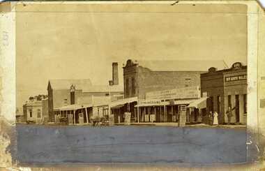
Photograph of western end of High Street, Charlton showing the Bank of Victoria, Malcolm's Flour Mill, Egan's, Golden Fleece Hotel, Johnson's Bridge Store, Dining Rooms and the Bank of New South Wales. c. 1883Early photo of High St, western end streetscapeSepia photograph of western end of High Street, Charlton showing the Bank of Victoria, Malcolm's Flour Mill, Egan's, Golden Fleece Hotel, Johnson's Bridge Store, Dining Rooms and the Bank of New South Wales. c. 1883. Man standing in front of the Bank, two ladies also standing on the footpath. Horse and cart in front of Johnson's store. Damage to the lower third of photo.bank of victoria, malcolm's flour mill, egan's, golden fleece hotel, johnson's bridge store, dining rooms, bank of new south wales, high street, business -
 Eltham District Historical Society Inc
Photograph, Bridge Street, Eltham, c. Sep. 1966
Last house on right is No. 122. The three houses on right remain relatively original in present time, the two visible houses on left have been substantially altered or replaced. Bridge Street ended at this point but has since been further extended eastBlack and white photographic printOriginally located in a Filmpro King Size Prints processing envelope $3.01 Shire of Eltham 9/9/66 and noted as Calrossie Ave area and crossed out Eltham-Yarra Glen Road, Bridge Street to Elsa Court existing conditions mid 1967eltham, infrastructure, road construction, roads, bridge street -
 Melbourne Tram Museum
Photograph - Digital Image, Kevin O'Reilly, series of three images of the Hawthorn Bridge over the Yarra, c1930, c1930's
Image from CD (Compact Diskette for use in computers) - see Reg Item 135. A series of three images of the Hawthorn Bridge over the Yarra, c1930, during the era with problems with the bridge. See separate article for more details. Richmond 6, Richmond, Richmond 3 on the CD as original files. .1 - Looking from the south west, at the Hawthorn bridge with the temporary wooden bridge being constructed on the south side. Has the cable tram depot in the photo and part of the Burnley racing course. Temporary track on the north side of the steel bridge and crossings can be seen. .2 - Looking along Bridge Road to the east with Hawthorn Bridge in the middle of the photograph. Shows the industrial and residential areas, Hawthorn Railway Station and part of the Burnley Race course, the cable tram depot building. W class tram in Church St Hawthorn and W class tram crossing the bridge on the north side temporary track. Note the cable tram used as a shelter on the north east corner of the bridge. .3 - Looking south along River St towards Bridge Road, with the Yarra River and Hawthorn Bridge on the left side of the photograph. Shows the industry in the area at the time, wool and skin Merchants, north side of the cable depot, housing and the outlook to the river!trams, tramways, hawthorn, yarra river, burnley, richmond, hawthorn bridge -
 Port of Echuca
Black and white photograph, Approx. 1975
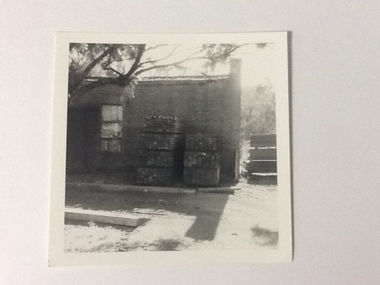
The old brick Murray River Sawmill office was demolished around 1975. This appears to be part of one of the office buildings associated with the sawmill, taken in shadow, with the building well back on the block, on the bridge side. There is a dirt driveway in front of the building and stacks of timber next to the chimney side of the building. Trees are visible behind these stacks of timber. Two stacks of timber (1x 4 blocks high, 1 X 3 blocks high) are in front of the building between the window and the chimney This relates to photographs P000106, P000105 Sawmills in the Echuca area were historically and socially significant being a large employer in the area. The Murray River sawmill was one of the biggest and longest operating sawmills in the area. Black and white photograph of an old Murray River Sawmill building with the chimney to the right and a door and window on the left. Two stacks of timber planks are against the wall between the window and the chimney. A dirt driveway is in front of the building with timber planks edging the driveway.On the reverse in pencil "Old M. R. S. Building well back on the block on the bridge side. Near old offices, also demolished about 1975??" Kodak, , in blue ink "0932"murray river sawmills, echuca, echuca, victoria, pullicino, j (unconfirmed) -
 Melbourne Tram Museum
Slide - Set of 2, John Webster, 21/07/1959 12:00:00 AM
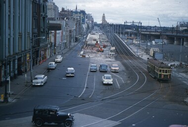
... Bridges ...Set of two Colour slides, Kodak, white cardboard of trams of the construction of the Flinders St overpass over King St from the railway viaduct over Spencer St, looking east. Shows the temporary track on the south side of the bridge and the large car park under construction from the former cool stores on this site. Also shows the former track into Spencer St. Note the cross over at the base of the bridge. .1 - possibly 357 running a route 27 to Spencer St. Has the Great Southern Hotel on the left side. .2 - similar photo taken from the viaduct, further along - has the Bushels and Penfolds Wines signs in the background.Hand writing on rear in ink; .1 and .2 - "2-4-60 - Tracks - Flinders St Melbourne" Both slides have the speed and the f reading on the left hand side.trams, tramways, trackwork, flinders st, king st, track construction, bridges, w2 class, route 27, tram 357? -
 Melbourne Tram Museum
Slide - Set of 4, Keith Caldwell, 16/03/1966 12:00:00 AM
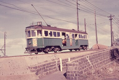
... Bridges ...Set of four Perutz colour slides, grey plastic mount, photo by Keith Caldwell of trams using the single track bridge over the Epping Rail line, (the hump), Preston Workshops - Miller St. .1 - W3 663, Route 9A, Northcote via St Georges Rd. .2 - W2 455 eastbound. showing special - route 11 .3 - W5 749 - as for .1 .4 - W5 - can't read the number. shows the bridge pier prior to be reinforced and the train tracks. 16/3/1966In ink "Bourke 14.3.66" and a purple date stamp.trams, tramways, miller st, the hump, w3 class, w2 class, w5 class, bridges, preston workshops, northcote, route 9a, tram 663, tram 355, tram 749 -
 Melbourne Tram Museum
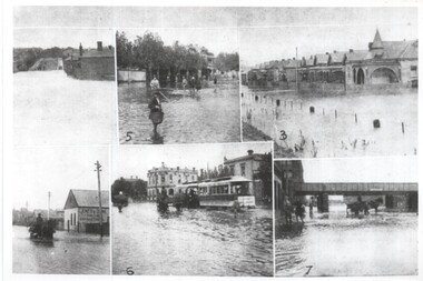
Photograph - Melbourne Flood scenes, 1910c
... Bridges ...Composite photograph from a journal showing six flood scenes in the South Melbourne and Port Melbourne area - undated. Photo No. 6 has been identified as Crockford St Port Melbourne. The image with the bridge is possibly Montague St. The photo on the left with a horse drawn cart, has the factory of Jones and Dunn Furniture Manufacturers.Yields information about a flood in the Port Melbourne area.Composite photograph of flood scenes in Melbourne - undated.Melbourne – Floods in the suburbs, No. 6 Crockford St Port Melbourne. Copy neg Mark Plummer collections ex late John Alfred collection.cable trams, melbourne, floods, crockford st, port melbourne, bridges, south melbourne -
 Melbourne Tram Museum
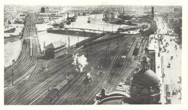
Photograph - Yarra River from Flinders St Station clock tower, Town and Country Journal, 1909
... bridges ...Photos show the Yarra river and the shipping turning basin that was used prior to the construction of the Spencer St bridge. In the view are are steam hauled suburban trains, Flinders St A signal box, Queensbridge, and the wharves on either side of the river. The viaduct was expanded to four tracks in 1915. Yields information about Yarra River, Flinders St railway station yards and shipping,Set of two photographs looking west from the Flinders St Station clocktower. over the Yarra River and station yards.On rear of both prints in ink: 1 – Melbourne - West from clock tower on Flinders St station - “Town and Country Journal 21/7/1909” Copy neg Mark Plummer collections ex late John Alfred collection. .2 - Melbourne, Looking west along Flinders St from clocktower of Flinders St station. Copy neg Mark Plummer collections ex late John Alfred collection. Has “T&C 20/12/09” in pencil on rear. bridges, flinders st station, yarra river, wharves, railways, signal boxes, queens bridge, shipping -
 Melbourne Tram Museum
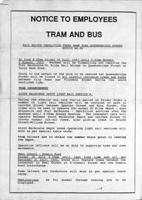
Document - Notice, Public Transport Corporation (PTC), Yarra Bank Road bridge demolition, July 1993
... bridges ...Notice to crews regarding altered tram arrangements for route 55 trams busses that used Queensbridge St during the demolition of the former St Kilda/Port Melbourne rail over bridge between 30/7/1993 and 2/8/1993. Notes that trams will be stabled in La Trobe St between Spencer St and Kings St.Yields information about the demolition of a rail bridge in Queensbridge St South Melbourne.Three A4 page document, stapled in top left hand corner.tramways, queens bridge street, yarra bank road, bridges, demolition, buses, trams -
 Bendigo Historical Society Inc.
Document - COHN BROTHERS COLLECTION: LANEWAY DOCUMENT, 1959
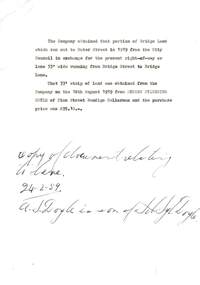
Document relating to a transfer of part of Bridge Lane and a 33' wide laneway between Bridge St. and Bridge Lane. The 33' strip of land was obtained from Andrew Sylvester Doyle of Finn St. Bendigo, Cellarman. Written in ink at the bottom is ' copy of document relating to lane 24/2/1959'organization, business, land transfer, cohn brothers , bridge street , bridge lane, andrew sylvester doyle -
 Kiewa Valley Historical Society
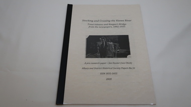
Book - Kiewa River, Stocking and Crossing the Kiewa River by Jan Hunter (nee Chick), 2020
The Chick brothers, Alf, Les and Allan, plus friends, began trout fishing and camping in the Kiewa Valley before the early 1930s. Les continued his connection with the Kiewa River until his death in 1972. Fingerlings were placed in the Kiewa River from the early 1880s. Keegan's Bridge is a crossing near Upper Gundowring and about 4 km south east of Dederang. References to the crossing were made in the early 1900s and a petition presented to Council in 1904 calling for a bridge.The bridge was built and opened in 1907. The photos are of the release of fingerling trout in the Kiewa River, thought to be at Keegan's Bridge. The fingerlings were transported in drums on the back of trucks. The photos are c1940s.The Kiewa Valley has been a popular spot for fishermen, tourists and campers from the 1880s. One of the many attractions has been the excellent fishing along the Kiewa River due to the regular release of fish especially brown trout. This continues to the present day (2020) when a few fish were marked with $$ signs for the lucky fisherman who caught them. This attracts visitors, their families and boosts the economy and dates back to visits at the Tawonga Pub prior to the Kiewa Hydro Electric Scheme.19 page book with black plastic spine and clear plastic cover over the beige paper cover with title , author and black & white photo. Note: In KVHS photo collection there are 4 good quality reproduction photos on photographic paper. These have been produced professionally. These photos of Jan Hunter's are featured on the second page of her book. These also have a letter attached. The book is a pre-research paper & is No 33 of the Albury and District Historical Society Papers. The sub-title is "Trout releases and Keegan's Bridge / from the newpapers, 1882-1935"None on the book but a letter is attached from Jan Hunter, the author as a follow up to the photos she donated. On the photos - On the back: Fujifilm / Fujicolor Crystal Archive / Paper / Production - run codekiewa river; trout; fish; keegan's crossing; keegan's bridge; fingerlings; chick family; camping; tourism -
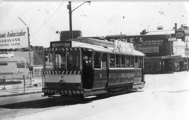 Ballarat Tramway Museum
Photograph - Black & White Photograph/s, David Clark, 17/02/1971 12:00:00 AM
Yields information about the Ballarat's tramcars in the months before closure and the appearance then of Stones Corner.Black and white photograph of Ballarat No. 21 in Victoria St, looking back to Stones Corner building. Photo by David Clark 17/2/1971. Tram has just left Bridge St. Stones Corner building in the background, and Viscount Ambassador Caravans to the left of the tram having replaced the Caltex Service Station on this location. Tram has the destination of Victoria St.On the rear in ink "Tram No. 21 in Victoria St, near Bridge St, looking to Sturt St. 17/2/71. Ballarat Tramways, Photo 30, Taken by David Clark", with David's address stamp "4 Adeney Ave Kew 3101" with "Melbourne" underneath.tramways, trams, victoria st, stones corner, bridge st, tram 21 -
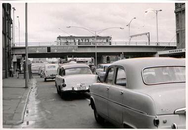 Melbourne Tram Museum
Photograph - Set of 6 Black & White Photograph/s, 1959 to 1960
... Bridges ...Set of 6 photographs of the Flinders St flyover over Kings St, soon after opening with tramcars and motor vehicles on the streets and bridge. Has the Waterside Hotel on the right side of the photographs. Has the pedestrian crossing traffic lights in the views. Don Storey's tramway history notes - http://www.classicaustraliantv.com/Gunzel.htm accessed 23/6/2019 notes that for 1959 - Temporary track on a new flyover in Flinders Street at King Street was brought into use; the permanent track was completed on June 26, 1960.Photos were contained within an envelope marked "Secretary Head Office MMTB (616 Lt Collins St) and "Please do not fold.trams, tramways, king st, flinders st, bridges, traffic lights -
 Glenelg Shire Council Cultural Collection
Document - Engineering report - typed, 10/02/1964
Five foolscap pages with typed information and photographs, Dartmoor Hamilton Road, Bridge over Humphy's Creek. Stapled top left, signed by E.J.E. Byrne, Bridge Inspecting Engineer.engineering, professional report, bridge, building works, dartmoor -
Glenelg Shire Council Cultural Collection
Negative - Glass Plate Negative - Botanic Gardens, c. 1890
Glass plate negative. Image shows 3 young women on bridge in Botanic Gardens - one of the bridges linking the islands. Dress estimated to be late 19th, early 20th Century.