Showing 126298 items
matching main-road
-
 Glen Eira Historical Society
Album - Album page, Booran Road, 30, Circa 1972
This photograph is part of the Caulfield Historical Album 1972. This album was created in approximately 1972 as part of a project by the Caulfield Historical Society to assist in identifying buildings worthy of preservation. The album is related to a Survey the Caulfield Historical Society developed in collaboration with the National Trust of Australia (Victoria) and Caulfield City Council to identify historic buildings within the City of Caulfield that warranted the protection of a National Trust Classification. Principal photographer thought to be Trevor Hart, member of Caulfield Historical Society. Most photographs were taken between 1966-1972 with a small number of photographs being older and from unknown sources. All photographs are black and white except where stated, with 386 photographs over 198 pages. From Glen Eira Heritage Management Plan 1996 by Andrew Ward: In 1888, John Leek, a trainer, owned Lot 15, measuring one and three quarter acres, in Booran Road, north side between Glen Eira and Neerim Roads. The land backed onto the Caulfield Racecourse Reserve. NAV was £45. In 1890 Leek built for his residence, a ten roomed brick house on the site. NAV was £200. Leek was the owner/trainer of "Ingliston" who won the Caulfield Cup in 1900. Upon the horse's death in 1901, Leek is understood to have defied tradition by spending £20 on boots for the "ragged urchins in Bourke Street" instead of "shouting" at the bar. By 1899, the property was owned and occupied by Alfred Merrill, a dentist and was known as "Andover". NA V had decreased to £ll0. By 1910, Leslie Macdonald, a gentleman had purchased the property and renamed it "Moidart". In 1910-11 Macdonald sold it to John Robertson. The property had extensive wood stables on its north-east boundary and several other outbuildings. The house continued to be described as "Brick, ten rooms" as it was in 1926 when it was owned and occupied by John Arthur, a managing director. The land measured la.2r.31p. and had a NAV of £235. Nine people lived there. In 1926, Arthur also owned the adjoining Lot 16. Other racehorses of note, known to have been stabled here include Sobar, Havelock, Proud, Future and Lord.Victorian Heritage Register https://vhd.heritagecouncil.vic.gov.au/places/13532 What is significant? Lord Lodge is a thoroughbred racehorse training complex adjacent to Caulfield Racecourse, established in 1890. The area immediately around the racecourse has been associated with horse racing activities and businesses servicing the industry since the development of the racecourse in late the 19th century. Lord Lodge was named by the present occupants after the champion racehorse Lord who was stabled there in the 1950s. In the early 20th century the property was known as 'Andover' and subsequently 'Moidart'. The site consists of a single storey brick Italianate villa, jockeys' quarters, stables and open day yards with direct access to Caulfield racecourse from the rear of the property. The villa of 10 rooms on bluestone foundations was constructed in 1890 by John Leek, a horse trainer who purchased the newly subdivided land in 1888. The house has many Victorian Italianate or Boom Style features although it is more modest than many villas of its style. It has an asymmetrical facade with a faceted bay window and a prominent central tower with low pitch pyramidal roof that provides a clear view of the racecourse. Other characteristic features include stilted segmented arches, bracketed eaves, stucco wall finish and cast cement ornamentation. A room has been added on the north-facing verandah in sympathetic style and finish. Internally the rooms are substantially intact with original marble fireplaces and intricate ceiling roses and cornices. An entrance toward the rear of the southern side of the house is said to be where the stable hands, jockeys and other staff lined up for their meals. In the southeast corner of the property, backing directly on to Caulfield racecourse, is a substantial late Victorian timber stable, probably constructed in the 1890s but first appearing on the property title in 1910. The stable has 12 stalls, a loft and brick pavement and jerkin head roof form with varnished pine-lined ceiling carried on a chamfered timber frame. It has an original roof lantern. The doors of the stalls are not the original sliding doors but swing doors obtained from a barn at Epsom Racecourse in Mordialloc prior to demolition. Outside the gambrel roof has fretted barges but the building is otherwise utilitarian. Timber throughout the stalls has been worn by chewing and rubbing of horses over the century of its use. In the southern half of the property are open day yards where the racehorses are kept during the day. The red brick, single storey jockeys' quarters to the rear of the villa were probably built around 1950. A small brick, possibly late Victorian structure on the eastern boundary thought to have originally been a gardening shed, has been converted to a stable of two stalls. Modern concrete brick stables fill the northeast portion of the property. At the front of the property two Moreton Bay Figs (Ficus macrophylla), probably planted in the late 19th century, provide shade for horses in the day yards. In the 1890s John Leek sold the property, relocating his training facility to one of the newly established racecourses at Mentone or Mordialloc (Epsom). By 1899, the property was owned and occupied by Alfred Merrill, a dentist, who named the property 'Andover'. In 1910 it was purchased by Leslie McDonald, a gentleman, and renamed 'Moidart'; sold in 1910-1911 to John Robertson; and again in 1926 to John Arthur, a racehorse owner. The Victorian Amateur Turf Club purchased the property in the late 1930s and since this time has been leased to racehorse trainers. It is unclear whether the property operated as a training facility between 1899 - 1926. Several notable trainers and jockeys are associated with Lord Lodge. The best known is Arthur 'Scobie' Breasley, Australia's most successful jockey who was apprenticed to trainer Pat Quinlan at Lord Lodge (then 'Moidart') from 1928 - 1935. Breasley rode winners of the Caulfield Cup in four successive years 1942-45 and again in 1952. John Leek, the original owner of Lord Lodge trained Ingliston, the 1900 Caulfield Cup winner. Along with 'Lord' a number of well known racehorses including Sobar, Havelock, Proud and Future were trained at Lord Lodge .....Page 40 of Photograph Album with three landscape photographs of the exterior of this house.Handwritten: 30 Booran Road [top right hand corner] / 40 [bottom right]trevor hart, jenny o'donnell, booran road, mansion, caulfield east, ingliston, sobar, havelock, proud, future, lord, andover, moidart, lord lodge, grace darling, caulfield racecourse reserve, victorian amateur turf club, historic buildings register, national estate register, caulfield cup, horses, stables, horse racing, racehorses, outbuildings, racehorse trainers, depression, 1890s, brick houses, mansions, towers, verandahs, stained glass, italianate style, victorian style, architectural features, architectural styles, john leek, leslie macdonald, john arthur, john robertson, alfred merrill, jenny odonnell -
 Stawell Historical Society Inc
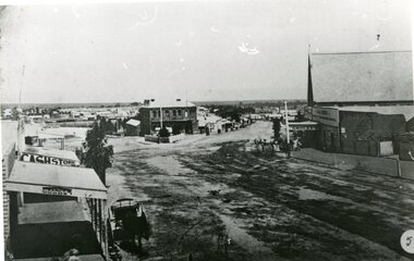
Photograph, Lower Main Street Stawell looking West towards the Unicorn Hotel later Coffee Palace
Lower Main Street looking West towards the Unicorn Hotel later the Coffee Palace. c1882 formerly the Castlemaine Hotel and before then the Royal Hotel. Bullock wagons and horse drawn buggies in street. Railway Goods Shed and Railway Station and Church of Christ visible in distance. Anglican Church roof on right, J & A Price Grocer and Spirit Merchants.B/W. Main Street opposite where the Town Hall is now. Stawell Coffee Palace is in the centre and the Anglican Church on the right. The date is about 1880.?stawell business streetscape -
 Ringwood and District Historical Society
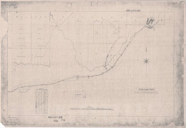
Map, Road Plan 108 - Gipps-land Road, Parishes of Bulleen and Warrandyte (Ringwood, Victoria) - 1855
Surveyor's map of the part of the main road from Melbourne to Gippsland following "Barker's Track" south of Mullum Mullum or Deep Creek. Map references include Roman numerals marking distances measured in Links between trees at turns in the road.Submitted to the Surveyor General (Signed) July 2nd 1855. -
 Camberwell Historical Society
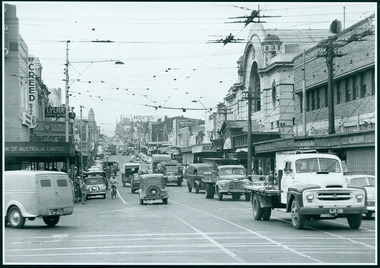
Photograph, Camberwell, Victoria, view of Burke Road and stores, c. 1950
Print of photograph looking north up Burke Road, with Rivoli Cinema on the right. Inscription 'Camberwell, Victoria, view of Burke Road and stores c. 1950' Camberwell, Victoria, view of Burke Road and stores c. 1950camberwell -
 Surrey Hills Historical Society Collection
Photograph, Union Road looking west from the steeple of Holy Trinity Church, 1922, 1922
At the edge of the church roof and on the horizon is 'The Knoll' on the corner of Union Road and Wandsworth Road. To the left of this is 297 Mont Albert Road, home of the Michael Parer family and further left is "Quamby", home of the Sherar family. This is easily recognised by the square viewing tower located on the west wing of the house. The Sherar family owned 'Quamby' from 1900 until 1925, when it became Mosgiel Private Hospital. Norman Carter took many photos of Surrey Hills and Mont Albert in the 1920s; many associated with events and activities of the Church of England. Black and white photo of taken from the steeple of Holy Trinity Church, during its construction, across Union Road to the north-west. In the foreground immature street trees can be seen and an original telephone pole with white insulators. The street has formed paths and bluestone kerb and channelling. holy trinity anglican church, union road, the knoll, quamby, street trees, telegraph and light poles, mosgiel hospital -
 Whitehorse Historical Society Inc.
Map, Map of Mitcham, 1916?
Copy of early map of Mitcham.Copy of early map of Mitcham showing main roads and large blocks of land with owners' namesCopy of early map of Mitcham. mitcham road mitcham, heatherdale road mitcham, whitehorse road mitcham, morton, william, ainger, f, morgan, r. r., harding, w, sergeant, r, mcclelland, john, wilson, w, cook, j -
 Ballarat Heritage Services
Photograph - Photograph - Colour, Darwin Main Street, China Town, c1912, 1912
The main street of Darwindarwin, china town -
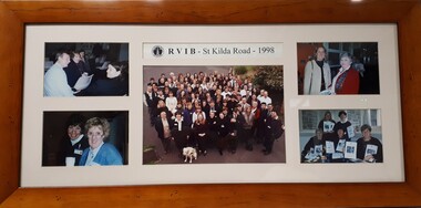 Vision Australia
Photograph (item) - Image, Staff at RVIB St Kilda Road - 1998, 1998
Five photographs of groups of staff members at RVIB. Image 1 - Maree Littlepage, Christine Harding, ?? Image 2 - ? and Sandie Mackevicius Image 3 - Group photograph in driveway: Blue letters: A - Chris Headland, B - Barbara Williams, C - Ramona Mandy, D - Barbara Royce, E – Tess Rousso, F – Robyn Gale, G – Peter Cronin, H – Chris Edwards, I – Glen Morrow, J – Graeme Craig, K – Barbara McKenzie, L – Marg Harvey, M – Judy Williams, N – Len Stephens, O – Nina Sutton, P – Sherry Cunningham, Q – Marissa Depitta, R – Uli Pfisterer, S – Rosemary, T – Maree Sheehan, U – Linda Rivette, V – Rachel Grealy, W – Fiona Pelusi, X – Maree Littlepage, Y – Danielle, Z – Sophie Tzoukalis. (Between Pelusi and Stephens, Christine Harding. Green letters: A – Emma Rogers-Wilson, B – Rory Fraser, C – Gary Stinchcombe, D – Alex Zolradkovic, E – Nicola Misso, F – Mary Barron, G – Barbara, H – Kathy Lazzaro, I – Linda Morris, J – Pam McAleese. Image 4 - ?? Image 5 - Robyn Gale, ??RVIB - St Kilda Road - 1998royal victorian institute for the blind, staff -
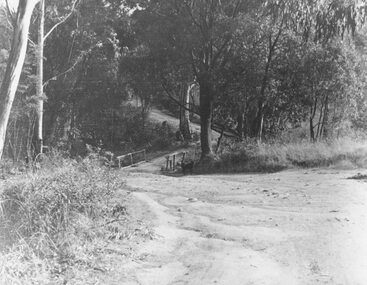 Ringwood and District Historical Society
Photograph, Deep Creek Road bridge early 1900s
Black and white photograph taken from unmade road. Road zigzags over bridge with wooden balustrades. Bushland setting. (3 copies)Typed below photograph, "Deep Creek Road bridge in the early days". -
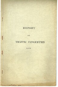 Melbourne Tram Museum
Document - Report, Road Board, "Report on Traffic Congestion", 1919
Report - 26 pages, printed, contained and stapled within a grey "Roneo Numeralpha System" folder, titled "Report on Traffic Congestion", containing a Victorian Parliamentary Report, dated 1919 with titled "Report of Board appointed to investigate the problem of relieving congestion of traffic in Melbourne." Full title "Report of Board Appointed to Investigate the problem of Relieving Congestion of Traffic in Melbourne" The Board or "Traffic Board" comprised 5 representatives of Councils, MMTB, Railways and the Public Works Department includes comments on growth of Melbourne, railways, tramways, new arterial roads, subways, new bridge at Spencer St, regulation of street traffic, looks at new tramway routes, hours works and provides a summary of recommendations including drawings for new arterial roads, graphs and roads / tramway layouts in two chain wide roads. Note: This document is available as a pdf on the Parliament of Victoria website. Second copy - unbound as printed, stapled on the left hand side, from McComb collection, box 10 - added 5/1/2017. added a 2nd copy from Russell Jones (28/05/22). Poor quality copy.Has in ink on the bottom edge "17th June 1919", Copy 2 - "H. Lormer"? in ink in the top right hand corner.trams, tramways, mmtb, general scheme, tramways, development, parliament, spencer st, railways, finances, construction, traffic control -
 Southern Sherbrooke Historical Society Inc.
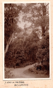
Photograph, A Bend In The Road, Belgrave, c. 1920s
Photo shows a bend in the road, Belgrave, most likely on Monbulk Road below Sherbrooke Forest. An unmade road crosses a small gully. A group of three or so young people are leaning over the bridge railing. The area is heavily treed. A BEND IN THE ROAD hand-wriiten in ink below the photo on the album page -
 Marysville & District Historical Society
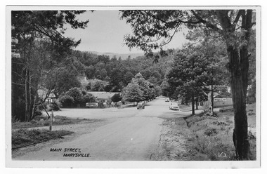
Postcard (Item) - Black and white postcard, Valentine Publishing Co. Pty. Ltd, Main Street, Marysville. V.3, 1923-1963
An early black and white photograph of the Main Street in Marysville, Victoria.An early black and white photograph of the Main Street in Marysville, Victoria. This street is now known as Murchison Street. In the background can be seen the Australia Hotel which became the Cumberland Hotel. The Cumberland Hotel was destroyed in the February 2009 Black Saturday bushfires and the Peppers Marysville was constructed on the site. Also in the background can be seen a sign with an arrow pointing to the Mary-Lyn Guest House which was also destroyed in the 2009 bushfires. This postcard was published by the Valentine Publishing Co. Pty. Ltd. as a souvenir of Marysville.VALENTINE'S/ POST CARD/ A GENUINE PHOTOGRAPHmurchison street, marysville, australia hotel, victoria, postcard, valentine publishing co, souvenir, cumberland hotel, mary-lyn guest house, 2009 black saturday bushfires -
 Marysville & District Historical Society
Postcard (item) - Black and white postcard, Valentine Publishing Co. Pty. Ltd, Main Street, Marysville. V.3, 1923-1963
An early black and white photograph of the Main Street in Marysville, Victoria.An early black and white photograph of the Main Street in Marysville, Victoria. This street is now known as Murchison Street. In the background can be seen the Australia Hotel which became the Cumberland Hotel. The Cumberland Hotel was destroyed in the February 2009 Black Saturday bushfires and the Peppers Marysville was constructed on the site. Also in the background can be seen a sign with an arrow pointing to the Mary-Lyn Guest House which was also destroyed in the 2009 bushfires. This postcard was published by the Valentine Publishing Co. Pty. Ltd. as a souvenir of Marysville.VALENTINE'S/ POST CARD/ A GENUINE PHOTOGRAPH 1940murchison street, marysville, australia hotel, victoria, postcard, valentine publishing co, souvenir, cumberland hotel, mary-lyn guest house, 2009 black saturday bushfires -
 Bendigo Military Museum
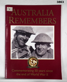
Book - BOOK, 50 YEARS, The Open Road, Australia Remembers, 1995
Australia Remembers 1945 - 1995. Commemorating 50 years since the end of World War II.Soft cardboard cover. Gold print on front / back over dark red background. Illustrated front / back & white photo of 2 uniformed soldiers. Black / white photo of a crowd scene on back. 80 cut, plain, glossy white pages. Illustrated black / white / sepia / colour photos, porters, paintings & drawings.book, remembers, 50 years, 1945 - 1995 -
 St Kilda Historical Society
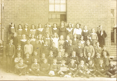
Photograph, St Kilda (Brighton Road)Primary School
Unable to read date in photograph but children's clothing suggests early 1900ssepia photograph mounted fair conditionSt Kilda (Brighton Road)Primary School. (?) Thomeson (?). 721 South Road, Moorabbin. Donated to the Historical Society. -
 Eltham District Historical Society Inc
Photograph, Eltham, February 1968, Feb 1968
Location and significance not yet identified for this structure which was part of the series of 48 photos taken along Main Road, Eltham in February 1968In February 1968 an unknown person took a series of photos from the Eltham Hotel at Pitt Street heading north along Main Road through the shopping centre to just north of Elsa Court covering the length of the section of Main Road which was duplicated shortly thereafter. Shows the condition and environment of the streesscape of Main Road, Eltham immediately prior to the duplication between Pitt Street and Elsa Court through the shopping centre. Also shows a number of shops and businesses that operated at that time.Black and white photographduplication, eltham, main road -
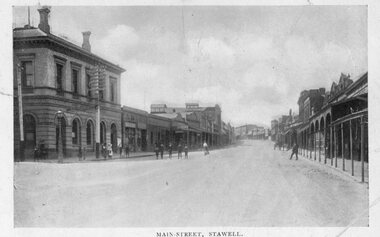
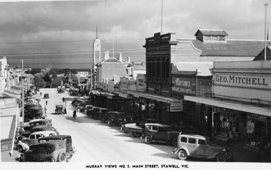 Stawell Historical Society Inc
Photograph, Main Street Stawell looking West with the Geo. Mitchell shop on right c 1940 -- Postcard
Murray Views No. 5. Main Street Stawell Vic. post card of street scene. The scene is looking west with the Geo Mitchell shop and Macrows furniture shop on the right. The street is full of parked cars c 1940's.Murray Views Postcard and also one enlargement of the street scene in Stawell looking west c 1940's.Murray View No. 5 Main Street, Stawell, Vic. (on the front) Real photograph produced in Australia by Murray View, Gympie, Q. (on the back). stawell business streetscape -
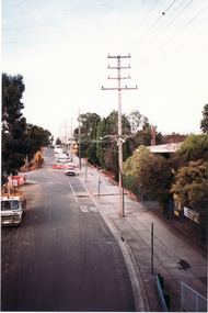 Whitehorse Historical Society Inc.
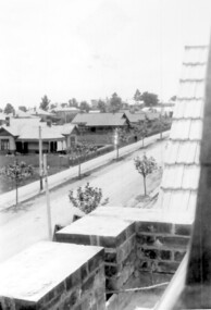
Photograph, Footbridge Whitehorse Road, 1/06/1999 12:00:00 AM
Coloured photo - From Footbridge in Whitehorse Road, Mitcham, looking towards Mitcham Road.whitehorse road, overhead powerlines -
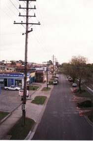 Whitehorse Historical Society Inc.
Photograph, Whitehorse Road Footbridge, 1/06/1999 12:00:00 AM
Coloured photo - From Whitehorse Road Footbridge in Mitcham, looking towards Rooks Road.whitehorse road, overhead powerlines -
 Stawell Historical Society Inc
Photograph, Main Street Stawell -- Postcard
Pre Motor Vehicle Street Scape. Gas Light and Telephone pole in front of Post Office.B/W. Main Street. Post.Office. up people - 1 man crossing road in front of card, woman is riding a bicycle up the steet. A group o fmen in front of Post Office another on the Street.Ajax Series POSTCARD Address Only -
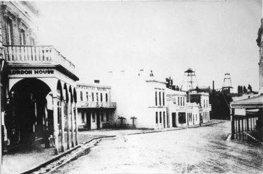 Stawell Historical Society Inc
Photograph, Upper Main Stawell Street looking East with London House on the left 1880
Upper Main Street looking East. c 1880. Chadwick's Draper / Liddiard's / London House on left. Commercial Hotel, Oriental Bank / Bank of Australia, Punchard Furniture, Earlier Union Bank. Extended Cross Reef and Sloane and Scotchmans poppet Heads in Background.Street scene of north side of upper Main Street looking east. London House on left, Commercial Hotel near centre of image. Two poppet heads of mines at right distance.stawell streetscape -
 Kew Historical Society Inc
Photograph, Stuart Tompkins Studio, Electricity Supply Poles, Burke Road, Kew, 1965
Research provided by Stuart Tompkins Studio, Box Hill, into alternatives for median strip street lighting to be used in Burke Road, Kew. The photographers identified variants in different suburbs appropriate to Kew's needs.The series from which the photograph is drawn provides a snapshot by a commercial photographic studio of each named vicinity in 1965 as well as providing examples of public works infrastructure being commissioned by local government in the 1960s. The photos originally formed part of the Engineering Department's files in the City of Kew before being donated to the kew Historical Society.Electricity Supply Poles, Burke Road, Kew, 1965. This photograph of Burke Road, Kew was taken just north of Kilby and Doncaster Roads looking north. Stuart Tompkins Studio provided the photograph for the Kew City Council. In the photograph are a number of electricity supply poles that have been erected in the median strip, in addition to some new poles on each footpath. The nearest wooden pole is stated to be 13.5″ in diameter. The electricity poles in Burke Road required Kew Council to investigate comparable designs in other Melbourne municipalities. [There are three copies of this photograph in the Collection.] Typed inscription on reverse: "Electricity Supply Poles. Photographed for Kew City Council 8/2/65. No.5 Burke Road - Kew, just north of Kilby and Doncaster Roads looking north. Some of seven poles already erected in median strip. Shows also some new poles erected on each footpath. Nearest wooden pole 13 1/2" dia." Studio stamp: "Stuart Tompkins Studio. 547 Station Street, Box Hill. WX1439."stuart tompkins studio, street lighting, south road (moorabin) 1965 -
 Surrey Hills Historical Society Collection
Photograph, 386-384 Canterbury Road Surrey Hills
The donor, Bob Lennox believed that these were the work of his great-grandfather William Lennox and his builders. William and his son were plasterers and often used the shell motif which is seen on the pediment of the buildings. These two terraces were part of the retail development of five terraces along Canterbury Road which were constructed on land subdivided from the parcel of land originally owned by John Woodhead. The Alan Holt register of properties in 3127 gives a list of proprietors / residents at the beginning of each decade from 1890-1980. There are also earlier photos depicting these buildings in the collection. These buildings have been included in the City of Boroondara Heritage Overlay Union Road Commercial Precinct 2011, Surrey Hills.These buildings were amongst the first commercial buildings serving the area of Surrey Hills and followed the extension of the railway from Camberwell in 1883.A colour photo with rounded corners taken from slightly diagonally across Canterbury Road from 2 double-storey Victorian style buildings. Both have the decorative shell motif in the pediment.Back of photo in green pencil "CANTERBURY RD SURREY HILLS / EAST OF UNION RD"victorian style, allegro graphics, william lennox, 386-384 canterbury road, shops, victorian terraces, canterbury road, surrey hills, john woodhead, heritage overlay union road commercial precinct 2011, heritage overlays -
 Mt Dandenong & District Historical Society Inc.
Photograph, Main Street, Olinda, c1930s
Number 10 in commercial seriesSmall photograph, number 10 in Olinda series, showing Main Street Olinda. View is looking NW from Olinda Monbulk Road towards Range Road. Left hand building is old Olinda Post Office. Ice truck is outside shops in distance and a delivery truck with tarp can be seen. c1930solinda, post office, truck -
Whitehorse Historical Society Inc.
Newspaper - Article, 575 Canterbury Road, Vermont, 3/08/1994
Canterbury Road, Vermont. Article on late 1950 weatherboard home at 575 Canterbury Road, Vermont.canterbury road, vermont, no 575 -
 Whitehorse Historical Society Inc.
Document, Auction Notice
Auction notice for 9 home sitesAuction notice for 9 home sites in Molleton Street, Baldwin Road and Main Street, BlackburnAuction notice for 9 home sitesauction notice for molleton street, baldwin road, blackburn -
 Camberwell Historical Society
Photograph, Camberwell, Victoria, view of Burke Road and stores, c. 1950
Print of photograph looking south down Burke Road with St Johns Anglican church tower in the background. Inscription 'Camberwell, Victoria, view of Burke Road and stores c. 1950' Camberwell, Victoria, view of Burke Road and stores c. 1950camberwell -
Whitehorse Historical Society Inc.
Map, This is Vermont, 1895-1920?
'Now you have seen it, tell your friends''Now you have seen it, tell your friends' - hand-drawn map of Vermont from Springvale Road to Heatherdale Road, showing the names of owners of houses, main roads and streets, shops and schools.'Now you have seen it, tell your friends' vermont south, vermont, roads and streets -
 Kiewa Valley Historical Society
Black and White photograph of Road Making Machinery, Kiewa Road Making 25/08/1938 No. 2, 25/08/1938
Construction of the main road from South Tawonga to the Bogong High Plains, to provide access to the construction sites for the new Kiewa Hydro Electric Scheme, was commenced early in 1938, the work being undertaken on behalf of the commission by the Country Roads Board. For the construction work, the Commission purchased three Caterpillar - model R07 - diesel crawler tractors equipped with Kay Brunerei (Brunner) hydraulically operated trailbuilders (angle dozers). This acquisition resulted from a visit to the United States of America in May, 1937 by the Construction Engineer ( Mr. C.H. Kernot) and Assistant Civil Engineer ( Mr. J.F. Douglas) where they saw this relatively new type of equipment in use. With the co-operation of the CRB, the Commission demonstrated the operation of these machines at Fishermen's Bend on 6th April, 1938. They were then sent to Kiewa where they commenced operation towards the end of the month. From South Tawonga, the route let immediately across the Western Branch of the Kiewa River necessitating the construction of a bridge 100 feet long. By the end of 1939, the excavation had been 'opened up' for a distance of 19 1/2 miles (approx. 31 km.) and of this length, 10 miles (approx. 16 km.) had been surfaced. (see KVHS 0328)The purchase of this type of mechanical equipment in road making was a huge investment, as prior to this most of the work would have been done manually with the use of picks and shovels. Not only were many months of hard manual labour saved, but a very significant amount of time in providing access to the proposed work sites for the new Kiewa Hydro Scheme. This photo is an excellent reminder of how primitive the early machinery was compared to the present but also represents the forward thinking of the State Electricity Commissions engineers in purchasing such innovative equipment.A black and white photograph of road making near Mt. Beauty in 1938. Mount Beauty hills can be seen in the background with cleared land for grazing in the fore ground.Hand printed in black ink at the top of the photograph is 'Kiewa Road Making 25/8/1938'. On the right hand corner has been printed the number 2. It has been printed on gloss Velox paper.road making, state electricity commission, caterpillar tractor, kiewa, secv