Showing 1969 items matching "tourists"
-
 Halls Gap & Grampians Historical Society
Book - B/W
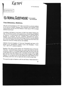
Norval Guest-House Aginda and Wettenhall The original Norval The story of Norval begins in 1917 when it was built as a private residence for Mr and Mrs William Thompson. Mrs Thompson was a pioneer of the tourist business, having come from Ballarat to Hall's Gap in 1909 to manage Bellfield Guest-house According to Ida Stanton, in her history of Hall's Gap entitled "Bridging the Gap", Mr Thompson and his wife acquired the six roomed shearers quarters at "Hankelow", on land leased by the Wettenhall family, on the south side of Bellfield. Mr Thompson, she says, completely dismantled the quarters, carefully marking each board, then hired George McKeon to cart the material up to where the original Norval house stood. With great care, the rooms were rebuilt into a home for William and his wife Mathilda. Catherine Good, the daughter of Viola (nee Wettenhall) and niece of Dr Roland, in here "Recollections" entitled "Look to the Mountains - Viola's View 1887-1979", mentions Hankelow. Speaking of her days at Glen Holford, the Wettenhall home at Pomonal, Viola says "Verona and Francie Dennis, my cousins, and I went for one very exciting trip. Father (i.e Dr Roland's father) had bought 300 acres in the Gap to take sheep from Carr's Plains in time of drought, and had a little cottage there with one of the Glen Holford men and his wife in charge. It was called Hankelow. So we three set off over the Range from Glen Holford on foot and leading a pack horse with our night attire and no doubt sponge bags. "We stayed the night at Hankelow with Jim and Minnie. Minnie had been a housemaid at Glen Holford. I was very fond of her. It makes one laugh to think of the excitement of "roughing it"! Minnie gave us a lovely dinner with meringues, and cream, I remember, then early morning tea. After breakfast we were driven in the buggy to the foot of the Goat Rock (since renamed Mt Rosea) and off we went - walking in our long skirts and ankle boots. There was no track of any kind, nor blazed trail - we just made for the top. It was rather frightening at times because we couldn't see where the top was an it always seemed to get further and further away. The last mile was so terribly steep, with a lot of lose shale where you went up twelve inches and slipped back six. Now you motor to about a couple of miles from the top and then have a graded path. Anyway, we got there and back safely and were rewarded with a magnificent view" By a strange coincidence, Hankelow, the source of Norval Guest-house in times past (if the name can be applied to the property as a whole, which seems likely) is in fact also the source of our Wettenhall Campsite! Hankelow was named after a property owned by the Wettenhall family in England. In 1917 William and Mathilda retired to their newly built home (Norval) "to escape from the tourist business" However, so many people made requests to stay with them that they found it necessary to add several more rooms and sleepouts to their home. In this way, early in 1921, the guest-house began to take shape. Mr Thompson, a former librarian of the Mechanics Institute in Ballarat, named the house "Norval". The name "Norval" comes from a quotation from the play 'Douglas" by John Home. Written in the mid-16th century the play is set in the Grampian Mountains of Scotland. The story is of a boy who was parted from this mother during his early childhood, and was given to a shepherd who raised him. Some eighteen years later the mother by chance happens to meet here son, and not knowing his true identity, asks his name. He answers, "My name is Norval; and in the Grampian hills my father feeds his flocks." Perhaps it was simply because "Norval" was associated with the "Grampians" that it was chosen by Mr Thompson. He may also have been conscious of feeding "flocks" of tourists in his expanding, guest-house. Norval Guest-house prospered. It was known for its fine cooking and friendly atmosphere - a tradition which has carried through to the modern Norval! It closed between 1940 and 1949 because of the second world war. In 1949 it was decided to almost completely rebuild the house. Most of the old building (Hankelow plus) was demolished and rebuilt to a much larger and more modern plan. And then, on May 1, 1965, it was purchased by the Committee of Management of the Methodist and Presbyterian Conference Centres. At this time the guest-house was owned and operated by Marjorie and Lachland McLennan, Mrs McLennan being the daughter of William and Mathilda Thompson, the pioneers of the establishment. The McLennans had operated the Guest-house since about 1930.Photocopy 2 pages of article from book titled 'In the Making' title of article Norval guest House the original Norvalaccommodation, guesthouses, norval -
 Bendigo Historical Society Inc.
Newspaper - LONG GULLY HISTORY GROUP COLLECTION: EAGLEHAWK ROAD - LONG GULLY
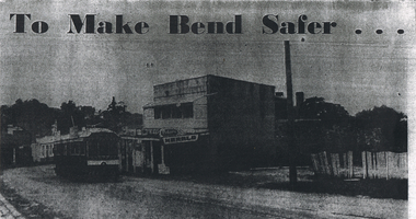
Copy of a newspaper photo titled To Make Bend Safer. Photo shows a tram passing a newsagent shop. On the right is a dilapidated picket fence. Allso hand written paper on one side is: Approx 1966 ? One of the last trams No 18 to run up Main Street of Long Gully (Bond Street) Now known as Eaglehawk Road. On Left - Post Office - now Gents Hairdresser & Rose of No 3 Australia Hotel. On Right - Les & Marie Norris Newsagency & Mixed Business. 2 story building was Commercial Hotel. No 26 Tram was the last to run between Bendigo, Long Gully & Eaglehawk. Still running as a Tourist. Donated by Alan Crossley. tram in Bendigo 1987 1985. On the other side is written: One building has already been demolished and the proprietor of the Newsagency & mixed business Mr. L W Norris, will also demolish and rebuild further back from the road in preparation for eventual re-alignment of the Long Gully bend by the Country Roads Board. The Board declared an alignment some years ago for the corner - a severe traffic hazard - but, the assistant Divisional Engineer, Mr G Marshallsea said yesterday the Board had no immediate plans. These were one of the last Trams to run through Long Gully.bendigo, history, long gully history group, the long gully history group - eaglehawk road - long gully -
 Melbourne Tram Museum
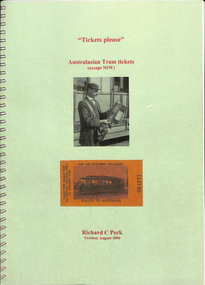
Book, Richard C Peck, "Tickets Please - Australasian tram tickets except NSW", Aug. 2006
Book - spiral wire bound , clear plastic cover, green title sheet and card back, approx. 110 pages, black and white presentation giving examples of tram tickets along with notes on each system for Melbourne, Country Victoria, Queensland, South Australia, Western Australia, Tasmania, New Zealand (11 systems) and Tourist tramways. Has a table of contents, introduction, an overview of the operators, list of Urban Transport Milestones During the Tramway Era for NZ and a story "Mystery Solved by Tram Ticket by Robert Pine as told by Jack McLean about a murder in London that was solved by a tram ticket found in the person's clothes. Rear page has purchase details of the book and CD, along with a contact address in Sydney. See Reg Item 5579 for the CD. Bob Merchant of the Sydney Tramway Museum advised 4/3/2021 that: Richard Peck, as Curator of Philately, Printing and Postal Technology, was responsible for the Museum of Applied Arts and Sciences acquiring major artefacts from the NSW Government Printing Office when it was forcibly closed by the government in 1989. In retirement Richard has researched the history of private bus routes before 1932 and government bus routes 1932-2021. He maintains a large database of all types of NSW transport tickets.trams, tramways, tickets, reports, melbourne, mmtb, stories -
 The Beechworth Burke Museum
Photograph, 1960s
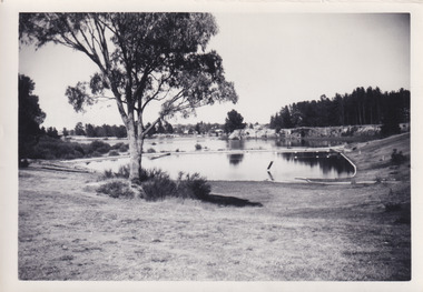
This photograph was taken in the 1960s of the Lake Sambell Swimming Pool with the lake itself in the background. The swimming pool area has multiple features including park benches, a water slide, and a fenced area with a diving pontoon for lap swimming and racing. Lake Sambell Swimming Pool was completed in 1961, driven largely by R.E. Carter, Beechworth shire engineer from 1954-63. Carter advocated for improvements to the lake and surrounding area in order to encourage tourism in Beechworth. The opening of the swimming pool was part of many improvements to Lake Sambell made during this period by Carter including establishing the caravan park in 1959, water skiing and boating facilities, and increasing the lake surface in 1964. These improvements were financed mainly by grants from the Tourist Development Authority. For many decades, members of the local Beechworth community had advocated for the development of swimming pool at the lake that would include a safe wadding area and Olympic standard lanes for laps and races. Throughout the 1940s the Beechworth Swimming Club tried to raise awareness and funds to address the structural engineering issues, raise the water levels, and improve swimming facilities at the lake. Beechworth Swimming Club hosted a swimming carnival at the lake in 1948, but it was decided due to several issues at the event, that no further carnivals would be hosted until necessary improvements were made to the area. Swimming pools, both artificial and built into natural environments, were an extremely popular public space throughout the 20th century in Australia. Increasing in accessibility and popularity through such developments as less restrictive swimming outfits during 1920s, public building works during the 1920s and 30s, and an increase in leisure time during a period of post-war prosperity. This photograph is of historical significance as it documents the newly established Lake Sambell Swimming Pool in the 1960s after many decades of discussion and proposals around creating a safe swimming area at the lake. Further, this photograph provides important social insights into the facilities and uses of this pool in the 1960s, and underlines the significant role public swimming pools have played in Australian social and recreational experiences. Black and white rectangle photograph printed on photographic paper and unmounted.Reverse: 3537 / C798lake sambell swimming pool, lake sambell water slide, water slide 1960s, lake sambell pontoon, lake sambell 1960s, lake swimming pool, lake swimming, beechworth swimming club, swimming pools in the 20th century, r.e. carter, tourist development authority, beechworth 1960s, lake water slide, lake sambell, wadding pool, swimming, swimming pool 1960s, leisure, recreation 1960s -
 The Beechworth Burke Museum
Photograph - Lantern Slide, c1900
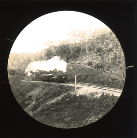
This slide shows a train proceeding along the Beechworth rail trail in approximately 1900. The rail line to Beechworth was the subject of significant lobbying by local officials such as John Orr and G.B. Kerferd in the 1860s, as it was recognised that the poor quality of roads to Melbourne and Albury hindered trade and formed a barrier to the social development of the town. The subsequent positioning of Beechworth on a branch rather than a main line was not considered ideal to achieve these aims, but the Everton-to-Beechworth and Beechworth-to-Yackandandah components of the line cost an average of £7,277 per mile and State Government officials felt the need in the area did not justify the cost of a direct line. The Beechworth Railway Station was officially opened on the 29th of September 1876 and ran services twice daily to Melbourne, transporting nearly 12,000 passengers and around 6,500 tons of cargo in 1900. It closed in 1976 and is today used as a cycling trail used by locals and promoted as a feature of the area to tourists. Lantern slides, sometimes called 'magic lantern' slides, are glass plates on which an image has been secured for the purpose of projection. Glass slides were etched or hand-painted for this purpose from the Eighteenth Century but the process became more popular and accessible to the public with the development of photographic-emulsion slides used with a 'Magic Lantern' device in the mid-Nineteenth Century. Photographic lantern slides comprise a double-negative emulsion layer (forming a positive image) between thin glass plates that are bound together. A number of processes existed to form and bind the emulsion layer to the base plate, including the albumen, wet plate collodion, gelatine dry plate and Woodburytype techniques. Lantern slides and magic lantern technologies are seen as foundational precursors to the development of modern photography and film-making techniques.This glass slide is significant because it provides insight into Beechworth's social amenities and transport infrastructure in the late Nineteenth Century. It is also an example of an early photographic and film-making technology in use in regional Victoria in the time period.Thin translucent sheet of glass with a circular image printed on the front and framed in a black backing. It is held together by metal strips to secure the edges of the slide.burke museum, beechworth, lantern slide, slide, glass slide, plate, burke museum collection, photograph, monochrome, indigo shire, north-east victoria, rail trail, beechworth rail trail, beechworth station, everton, wangaratta, wodonga, albury, rail transport, cargo transport, g.b. kerferd, john orr, murray to mountains rail trail, cycling, biking, railway -
 Eltham District Historical Society Inc
Negative - Photograph, Russell Yeoman, Shire of Eltham War Memorial, Memorial Park, Garden Hill, Eltham-Yarra Glen Road, Kangaroo Ground, c.1980
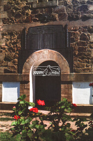
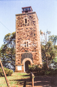
Shire of Eltham War Memorial Tower at Kangarooo Ground; view from the east and close up of entrance including Honour Roll. On November 11th 1926 the Shire of Eltham War Memorial Tower at Kangaroo Ground was opened. It is regarded as one of Melbourne’s most outstanding lookout towers. It commands a magnificent 360 degree panorama from Kinglake across the Diamond Valley to Macedon and the You Yangs. It is built on a peak which was once a volcano, 237 metres above sea level. After World War one a memorial cairn was erected on the site, and in 1925 a committee of public-minded citizens began to plan for a tower. Many generous donations of material and money were forthcoming so that in 1926 the Governor General Lord Stonehaven was able to unveil the plaque before a crowd of 500 people There was some concern in the 1960s when the Forests Commission wanted to build a firespotters cabin on the top. At first R.S.L. branches opposed the idea, but it was realised that this use could combine with its use as a tourist attraction, and would ensure its maintenance for the future. Today the Kangaroo Ground tower provides one of the best views around Melbourne and is a fitting memorial to those who died in two world wars. From: Historic items for Diamond Valley Community Radio September 1990 (EDHS collection) On November 8th, 1951, the memorial was re-dedicated by the Governor of Victoria, Sir Dallas Brooks with the addition of the names of men from the Shire of Eltham who fell in the Second World War. Further wreaths were added subsequent to this image in time for the 2001 Reembrance Day service to commemorate the men from th shire who had fallen in the Malayan, Korean, Borneo and Vietnam campaigns.Roll of 35mm colour negative film, 2 strips Kodak Safety 5035 Colour print (x1)Kodak Safety 5035garden hill, kangaroo ground, kangaroo ground memorial, memorial park, shire of eltham war memorial, shire of eltham war memorial tower, war memorial, kangaroo ground relief committee -
 Eltham District Historical Society Inc
Negative - Photograph, Russell Yeoman, Shire of Eltham War Memorial, Memorial Park, Garden Hill, Eltham-Yarra Glen Road, Kangaroo Ground, c.1980
Shire of Eltham War Memorial Tower at Kangarooo Ground; view from the east and close up of entrance including Honour Roll. On November 11th 1926 the Shire of Eltham War Memorial Tower at Kangaroo Ground was opened. It is regarded as one of Melbourne’s most outstanding lookout towers. It commands a magnificent 360 degree panorama from Kinglake across the Diamond Valley to Macedon and the You Yangs. It is built on a peak which was once a volcano, 237 metres above sea level. After World War one a memorial cairn was erected on the site, and in 1925 a committee of public-minded citizens began to plan for a tower. Many generous donations of material and money were forthcoming so that in 1926 the Governor General Lord Stonehaven was able to unveil the plaque before a crowd of 500 people There was some concern in the 1960s when the Forests Commission wanted to build a firespotters cabin on the top. At first R.S.L. branches opposed the idea, but it was realised that this use could combine with its use as a tourist attraction, and would ensure its maintenance for the future. Today the Kangaroo Ground tower provides one of the best views around Melbourne and is a fitting memorial to those who died in two world wars. From: Historic items for Diamond Valley Community Radio September 1990 (EDHS collection) On November 8th, 1951, the memorial was re-dedicated by the Governor of Victoria, Sir Dallas Brooks with the addition of the names of men from the Shire of Eltham who fell in the Second World War. Further wreaths were added subsequent to this image in time for the 2001 Reembrance Day service to commemorate the men from th shire who had fallen in the Malayan, Korean, Borneo and Vietnam campaigns.Roll of 35mm colour negative film, 2 strips Colour print (x1)Kodak Safety 5035garden hill, kangaroo ground, kangaroo ground memorial, memorial park, shire of eltham war memorial tower, war memorial, garden hill, kangaroo ground, kangaroo ground memorial, kangaroo ground relief committee, memorial park, shire of eltham war memorial tower, war memorial, shire of eltham war memorial -
 Eltham District Historical Society Inc
Photograph, Shire of Eltham War Memorial, Memorial Park, Garden Hill, Eltham-Yarra Glen Road, Kangaroo Ground, c.1936
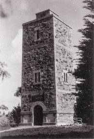
Showing front angle view of tower and old fire watchbox on top On November 11th 1926 the Shire of Eltham War Memorial Tower at Kangaroo Ground was opened. It is regarded as one of Melbourne’s most outstanding lookout towers. It commands a magnificent 360 degree panorama from Kinglake across the Diamond Valley to Macedon and the You Yangs. It is built on a peak which was once a volcano, 237 metres above sea level. After World War one a memorial cairn was erected on the site, and in 1925 a committee of public-minded citizens began to plan for a tower. Many generous donations of material and money were forthcoming so that in 1926 the Governor General Lord Stonehaven was able to unveil the plaque before a crowd of 500 people There was some concern in the 1960s when the Forests Commission wanted to build a firespotters cabin on the top. At first R.S.L. branches opposed the idea, but it was realised that this use could combine with its use as a tourist attraction, and would ensure its maintenance for the future. Today the Kangaroo Ground tower provides one of the best views around Melbourne and is a fitting memorial to those who died in two world wars. From: Historic items for Diamond Valley Community Radio September 1990 (EDHS collection) On November 8th, 1951, the memorial was re-dedicated by the Governor of Victoria, Sir Dallas Brooks with the addition of the names of men from the Shire of Eltham who fell in the Second World War. Further wreaths were added subsequent to this image in time for the 2001 Reembrance Day service to commemorate the men from th shire who had fallen in the Malayan, Korean, Borneo and Vietnam campaigns.Black and white photograph showing front angle view of tower and old watchbox on topgarden hill, kangaroo ground, kangaroo ground memorial, memorial park, shire of eltham war memorial tower, war memorial -
 Wangaratta RSL Sub Branch
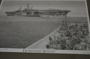
Print - Framed print, HMAS Sydney, 2008
Depicting the boarding of Australian Troops from Vung Tau, Vietnam for return to Australia following active service in Vietnam. HMAS Sydney was a Majestic-class light aircraft carrier operated by the Royal Australian Navy (RAN). She was built for the Royal Navy and launched as HMS Terrible (93) in 1944, but was not completed before the end of World War II. The carrier was sold to Australia in 1947, completed, and commissioned into the RAN as Sydney in 1948. Sydney was the first of three conventional aircraft carriers to serve in the RAN, and operated as the navy's flagship during the early part of her career. From late 1951 to early 1952, she operated off the coast of Korea during the Korean War, making her the first carrier owned by a Commonwealth Dominion, and the only carrier in the RAN, to see wartime service. Retasked as a training vessel following the 1955 arrival of her modernised sister ship, HMAS Melbourne, Sydney remained in service until 1958, when she was placed in reserve as surplus to requirements. The need for a sealift capability saw the ship modified for service as a fast troop transport, and recommissioned in 1962. Sydney was initially used for training and a single supply run in support of Malaysia's defence policy against Indonesia, but in 1965, she sailed on the first voyage to Vũng Tàu, transporting soldiers and equipment to serve in the Vietnam War. 25 voyages to Vietnam were made between 1965 and 1972, earning the ship the nickname "Vung Tau Ferry". Sydney was decommissioned in 1973, and was not replaced. Despite several plans to preserve all or part of the ship as a maritime museum, tourist attraction, or car park, the carrier was sold to a South Korean steel mill for scrapping in 1975A pictorial image of troops returning to Australia from Vietnam.Timber frame with mount containing print of ship at sea and soldiers in a barge in foreground.Homeward Boundhmas sydney, ran -
 Melbourne Tram Museum
Document - Folder with papers, The Met, "Melbourne Met Pass", Sep. 1987
Folder containing various documents regarding the launch of the "Melbourne Met Pass". .1 - Green coloured folded card folder with the Met logo and "Metropolitan Transit" on the outside and two The Met business cards for Jennie Owers - Manager Sales and Services and Margaret Douglas, General Manager Marketing stapled to the inside. .2 - Two page press release headed "Victoria Transport", dated 19/9/1987 regarding the launch of the new Tourist Package by the Met, has quotes from MTA Managing Director - Kevin Shea and Minister Tom Roper. .3 - Folded card A5 sheet, titled "All the information you need to tell them where to go", contains retail and wholesale price information and information on the packages available. .4 - Poster, printed on gloss paper and folded titled "101 things to see around Melbourne" advertising what you could see using the Met Pass. Contained within a green plastic folder titled "Melbourne Met Pass" .5 - book - 80 pages, card cover, printed on gloss paper - a very extensive guide to Melbourne and suggested trips. .6 - folded map showing both the train and tram systems containing information about the zones, art galleries, shopping, gardens sports Arena, museums and eating. .7 - Sample Met Pass - not numbered - printed on yellow card with green ink and conditions of travel on rear.trams, tramways, the met, tourist tickets -
 Bendigo Historical Society Inc.
Map - Laminated map of Lake Eppalock at full capacity. Map 'E'
John Perry Collection. Laminated map of Lake Eppalock at full capacity. Black and white. The dam was built by the State Rivers and Water Supply Commission of Victoria. The dam wall height is 45 metres (148 ft) and the main embankment is 1,041 metres (3,415 ft) long. At 100% capacity the dam wall was designed to hold back 304,651 megalitres (6.7014×10¹⁰ imp gal; 8.0480×10¹⁰ US gal) of water. The surface area of Lake Eppalock is 3,011 hectares (7,440 acres) and the catchment area is 2,124 square kilometres (820 sq mi). The controlled spillway is capable of discharging 8,040 cubic metres per second (284,000 cu ft/s). Lake Eppalock supplies both stock and domestic water to the Campaspe irrigation district. It also serves as a water supply to Bendigo and Heathcote and, in more recent times, Ballarat. The lake is a major attraction for those engaging in watersports, with a number of tourist parks and accommodation facilities available. Permissible activities on the lake include high-speed boating, water skiing, sailing, canoeing, fishing and swimming. The lake's water levels were low for approximately eight years between 2002 and 2010 during a prolonged drought, which restricted the amount of recreational activity until rainfall in the latter half of 2010 returned the lake to 100 percent capacity. Built between 1961 and 1964, Lake Eppalock remains the only water storage on the Campaspe River system.map, eppalock, water, dam, reservoir -
 Port of Echuca
Audio - Oral History - Geoff Evans, Oral History of Geoffrey Thomas Evans of Echuca b1924 d 2007
Geoff Evans was the third generation to run Evans Brothers Sawmills that operated from the northern end of the Echuca Wharf from 1923 to 1983. His grandfather Richard James Evans orig. of England, settled in Victoria at a young age. He first worked as a butcher and later cut firewood in the Heathcote and Bacchus Marsh area. ‘R.J.’, as he was known established a sawmill at Barmah in the 1890s, before relocating to this site in 1923. It became known officially as the Evans Bros. Echuca Red Gum Sawmill. This site proved more economical due to its position at the railhead. Paddlesteamers towed barges carrying the logs from the surrounding forests to this mill. The Steamers that were owned by the Evans family were the Edwards (built 1875) and the Melbourne (built 1912). The Edwards was the main towing vessel. Outrigger barges at this mill were the Impulse (1885), Alison (1907), Clyde (once a paddlesteamer, built in 1884). Insider barges at the mill were old wool barges with iron topsides, the J.L.Roberts (1894), ADA (1899) and the Whaler which was of wooden construction. The Evans Mill cut both red gum and Murray pine. There was a main mill for the red gum and a second one for the pine on this site. Two new Marshall steam engines had been purchased by the family, one was used in the P.S. Edwards and the other for the Barmah mill and later this site. The Evans Bros. Mill was very much a family concern with it being owned and operated firstly by R.J., then his son Frederick. R. Evans and later grandson Geoff Evans. The mill employed 18 workers and operated until the 1980s, only briefly was it in the hands of other owners before the construction on part of the site of a tourist-oriented building known as the Red Gum Works which eventually made way for the Port of Echuca Discovery Centre in 2014.Knowledge of the redgum timber milling industry and associated mechanisms such as log slips is scant with little photographic representations to be found. The industry created alongside the Murray River in various places was very unique given the nature of red gum not floating and ingenuity and making use of local resources was required. Geoff Evans had firsthand knowledge of much of this process and how the Echuca Wharf area used to be in past decades. Geoff was also a popular musician and mayor of Echuca so had much knowledge of the local history and community.Digital recording of oral history interview with Geoff Evans of Evans Brothers Sawmill Echuca. evans bros, evans bros saw mills, evans' sawmill, geoff evans, log slip, log skid, p.s. edwards, p.s. melbourne, impulse barge, allison barge, clyde barge, j.l. roberts barge, ada barge, whaler barge, murray pine, redgum, marshall engines, r.j evans, f.j. evans, discovery centre, p.s. marion -
 Montmorency–Eltham RSL Sub Branch
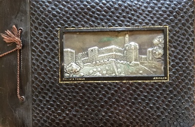
Album - Nicholson Photo Album
Photographic record of overseas places visited by local resident who was a member of armed service during WW2. Des Nicholson was born in Northcote in 1909. He enlisted in the military in mid 1940, having already served 2 years in the Citizens’ Forces. Before he signed up, he lived in Kew with his mother, Isabella. His enlistment documents indicate that he was employed as a transport driver, although his discharge papers state that he was a hairdresser. His photo album shows pictures of him demonstrating skills in that area in various deployments overseas; his enlistment documents refer to his unit being the 8th Division Petrol Company, while for much of his service he was assigned to Nursing Duties in the 2/7 Australian General Hospital. His overseas postings included travels through India to the Middle East, Egypt and Greece. While fulfilling these duties, he was an interested photographer, keeping records of the sights he saw in many of the places he visited, as well as photos of the military living conditions and the people he worked with on a day-to-day basis. The ‘tourist’ photos Des took would be of particular interest as a current-day comparison for those folk who might be familiar with the locations he passed through. After the war, Des again lived with his mother but eventually, in 1953, he married Kathleen Watson who lived in Eltham. The wider Watson family was well-known in the area, and the sisters Kathleen and Ruby were residents in the Glen Park area in Eltham North. After Des and Kath married they continued to live in Kath and Ruby’s house near where the current soccer and cricket sporting complex is now located. Ruby never married and they evidently stayed in the same place until, one by one, they each died in the early 2000s. Photos taken by a resident of Eltham while on active service overseasPhoto AlbumOn Front Cover: DAVID'S TOWER JERUSALEMphotographs, ww2, overseas, india, middle east -
 Eltham District Historical Society Inc
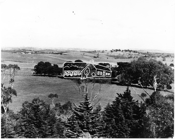
Photograph, View of Kangaroo Ground District from War Memorial Tower, 16 November 1951, 16 Nov. 1951
View from Shire of Eltham War Memorial tower at Garden Hill, Kangaroo Ground, probably taken shortly after the memorial's re-dedication held 8 Nov. 1951. On November 11th 1926 the Shire of Eltham War Memorial Tower at Kangaroo Ground was opened. It is regarded as one of Melbourne’s most outstanding lookout towers. It commands a magnificent 360 degree panorama from Kinglake across the Diamond Valley to Macedon and the You Yangs. It is built on a peak which was once a volcano, 237 metres above sea level. After World War one a memorial cairn was erected on the site, and in 1925 a committee of public-minded citizens began to plan for a tower. Many generous donations of material and money were forthcoming so that in 1926 the Governor General Lord Stonehaven was able to unveil the plaque before a crowd of 500 people There was some concern in the 1960s when the Forests Commission wanted to build a firespotters cabin on the top. At first R.S.L. branches opposed the idea, but it was realised that this use could combine with its use as a tourist attraction, and would ensure its maintenance for the future. Today the Kangaroo Ground tower provides one of the best views around Melbourne and is a fitting memorial to those who died in two world wars. From: Historic items for Diamond Valley Community Radio September 1990 (EDHS collection) On November 8th, 1951, the memorial was re-dedicated by the Governor of Victoria, Sir Dallas Brookes with the addition of the names of men from the Shire of Eltham who fell in the Second World War. Further wreaths were added in time for the 2001 Reembrance Day service to commemorate the men from th shire who had fallen in the Malayan, Korean, Borneo and Vietnam campaigns.This photo forms part of a collection of photographs gathered by the Shire of Eltham for their centenary project book,"Pioneers and Painters: 100 years of the Shire of Eltham" by Alan Marshall (1971). The collection of over 500 images is held in partnership between Eltham District Historical Society and Yarra Plenty Regional Library (Eltham Library) and is now formally known as the 'The Shire of Eltham Pioneers Photograph Collection.' It is significant in being the first community sourced collection representing the places and people of the Shire's first one hundred years.Digital image 120 format B&W negative B&W Print 12.5 x 17.5 cmsepp, shire of eltham pioneers photograph collection, kangaroo ground, garden hill, kangaroo ground tower, lookout, memorial park, panorama, shire of eltham war memorial, view, vista -
 Flagstaff Hill Maritime Museum and Village
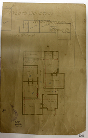
Document - Plan, Pilots Quarters Warrnambool
Warrnambool was officially made a Port of Entry in 1855 and by the 1870s had became the dominant port in the Western District. Sadly, due to an increasing problem with silting in the harbour, by the 1890s only small vessels could navigate the harbour. Men with the position of Pilot and Harbourmaster in Warrnambool were employed by the government to enforce government regulations and to help guide vessels safely into the port of Lady Bay, which was difficult to navigate. Some of the Pilots and Harbour Masters of Warrnambool were – - Captain Christopher Gwatkin, the first Harbourmaster for Warrnambool (1857 - his death in 1859). - Captain Helpman was Warrnambool’s second Harbourmaster 1859-1869 - James Nicol was Harbourmaster in Warrnambool for a time, including 1906 (b. 1840 – d. 1926) - Thomas Smith Drewett (1853 - 15-3-1905) past Captain of the Helen Nicoll, Pilot and Harbourmaster of Warrnambool. Warrnambool’s Tourist Guide of 1888 advises that “At the Port of Warrnambool there are two Leading Lighthouses. A licensed sea pilot, Captain Drewett, is stationed at the Port.” In 1915 plans for the Pilot’s Quarters were drawn up for the Department of Public Work. It was at that time, when personnel was short due to the First World War, that apparently the Pilot and Harbourmaster was also responsible for maintaining the light (lighthouse). The new Pilot and Harbourmaster’s house would be built on the site at 88 Merri Street, overlooking Lady Bay and right beside the Flagstaff and the Lady Bay Upper Lighthouse. Other Pilot and Harbourmasters were - - James Menzies was the Pilot and Harbourmaster at Warrnambool in 1929 . In 1932, he was appointed to the position of Acting Secretary to the Warrnambool Harbour Board. A hundred or so years later Flagstaff Hill Maritime Village has fully renovated the former Harbourmaster’s quarters, changed the name to Lighthouse Lodge, and is now allowing guests to stay in the home, which is still neighbour to the operational Lady Bay Lighthouses, now over 150 years old. The association of the old Pilot and Harbourmaster’s Quarters (currently renamed as Lighthouse Lodge) with the Port of Warrnambool, and its maritime activities, is historically significant. The Pilot’s quarters are connected to a time when access to Warrnambool’s Port was important to the colonial settlers for income and supplies. Plan of Pilots Quarters, Warrnambool. Printed and handwritten plan shows house, garage, out buildings and maid's room. The plan's lower left corner has an official stamp and text beside the stamp. Department of Public Works, Melbourne, Victoria, March 11th, 1915. "PILOTS QUARTERS WARRNAMBOOL" "Department of Public works, Melbourne, Victoria I.P.K. , 11.3.15"flagstaff hill, warrnambool, shipwrecked-coast, flagstaff-hill, flagstaff-hill-maritime-museum, maritime-museum, shipwreck-coast, flagstaff-hill-maritime-village, plan, pilot's quarters warrnambool, pilot and harbourmaster's quarters warrnambool, pilot and harbour master's quarters warrnambool, port of warrnambool, department of public works victoria, lady bay lighthouses, warrnambool ports and harbours -
 Puffing Billy Railway
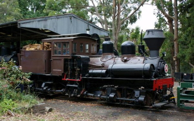
Number 14 - Shay Locomotive (Builder’s Number 2549), 22 June 1912
geared steam locomotive Built by the Lima Locomotive Works, USA in 1912 (Builder’s Number 2549). “Class a” 13 Ton (13.3 tonne) . This locomotive hauled freight on the Ali-Shan Forest Railway in Taiwan and is capable of pulling 90 Tons (91.8 tone) loads over steep gradients at low speeds. . This A-type Shay locomotive was built by Lima Locomotive Works, Ohio (builder's number 2549 of 1912) for the Alishan Forest Railway, Taiwan. The Alishan Forest Railway featured a large fleet of Shay locomotives and many still survive, together with a portion of the railway which is now a tourist operation. Alishan Shay No.14 was gifted to the Puffing Billy railway in 1971 by the Alishan Forest Railway - Taiwan Government forest Bureau and arrived on the 12th October 1971 at the Puffing Billy Museum at Menzies Creek. Loco: Shay No.14 ( Shop Number 2549 ) Class: A 18-2 ( 2-cylinders / 2-trucks Class A ) Built for: Alishan Forest Railway Bulit by Lima Locomotive Corporation In service 22 June 1912 Samuels, Samuels & Co., Ltd. (D), Taipei, Formosa (Japan); For: Alishan Forest RY #14, Kirun (Keelung), Formosa, (Japan) (1945) Alishan Forest RY #14, Keelung (Chilung), Taiwan (12 Oct 1971) Puffing Billy RY #14, Belgrave, Victoria, Australia Gauge 30" Status Preserved - In Storage at Museum There is only one original LIMA mark left on any of the Alishan RY Shays and it has no number. All of their Shays have been re-built, changing much of the original Lima product. Most were renumbered for various reasons without regard to Lima Shop Numbers over the years. "Girder Type Frame" details from http://www.shaylocomotives.com/data/lima3354/sn-2549.htm Historic - Industrial Narrow Gauge Railway - Geared Steam Locomotive which worked on the Alishan Forest Railway, Taiwan.geared steam locomotive - Class: A 18-2 ( 2-cylinders / 2-trucks Class A ) - made of wood and iron and wrought iron, Glass14puffing billy, shay, geared locomotive, steam locomotive, industrial narrow gauge railway, 2'6", ali shan forest railway -
Dutch Australian Heritage Centre Victoria
tourists bicycle pennants, mid 20th century
TourismHow people went on holiday. A memento of simple holidays. The tradition of camping as the holiday of choice.calico, triangular pennant. One edged in blue, the other in red.4089.R1 - blue edged pennant, showing the tourist sites around a place called Epen in the southern part of the province of Limburg. This is known because the name of the town is in large red letters. Three locations shown 1. Kamper Boerderij - A farm providing camping grounds. 2. Kasteel Beusdael - The Beusdael Castle 3. Wingbergermoelen - Wingberger Mill Also a little tent beneath the name of the town, with refers to the camping holiday. Also a maker's mark on the pennant, a small triangle with the letters L, A & B within it. 4089.R2 - red edged pennant, showing the area around Vaals in Limburg province, the name is in large red letters. The scene shows the meeting point between the Netherlands, Germany & Belgium - "Drie Landen Punt" (Three Country Meeting Point) Also shows the height of the viewing point (193m), as well showing other features including: - Hotel Bellevue - Uitzichttoren - viewing tower - Panorama Aken - Panorama of Aachen, Germany - Spoorbrug-Moresnet - Railwaybridge-Moresnet in Belgium. Small makers mark. Black triangle, possible the same as that shown in the other pennant, though obscured. -
 Melbourne Tram Museum
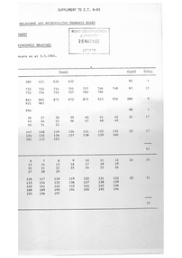
Administrative record - Depot List, The Met, "Allocation of Tramcars as at 5-5-1983", Aug. 1983
Photocopied A4 document, 8 sheets, stapled in top left hand corner, titled "Allocation of Tramcars as at 5-5-1983", listing the class of trams allocated to each depot in Melbourne, MMTB, training trams, storage, special purpose trams, summary. The last page has a an extract from page 97 of the June 1983 issue of ET giving a bus fleeing location of the MMTB and notes on Private Bus companies and services. Has been photocopied onto A4 sheets - and published as a supplement to E.T 6/83. Has a stamp of the Road Construction Authority of 25 august 1983 Library on the front sheet. 2nd copy added from donation of Norm Cross. 1519.1 - 12 A4 sheets, were stapled in top left hand corner, titled "Workshops and Running sheds Branch - Allocation of Tramcars 4-4-1983". Sheets 1 to 5 - Allocation of Tramcars in Numerical Order including listing of tramcars for storage and disposal and storage and retention in operating condition. Letters against trams possibly withdrawn, hand written changes and additions to the Z3 class fleet to 220, Sheets 6 to 11 - allocation by depot showing some crossed out in red including trams in workshops, reserve trams, Approved disposal, training, tourist, special purpose, Ministry of Arts and decorated cars. Sheet 9 - distribution list. 1519.2 - full copy unaltered from Robert Green, added 6/7/2019 - see 1519i3.pdf for scanned copy.trams, tramways, tramcars, mmtb, lists, depots, depot allocation, transporting art, buses -
 Bendigo Historical Society Inc.
Map - Laminated map of Lake Eppalock at full capacity
John Perry Collection. Laminated copy of map of Lake Eppalock at full capacity. Had highlighter markings of old roads which appear to be still in use. The dam was built by the State Rivers and Water Supply Commission of Victoria. The dam wall height is 45 metres (148 ft) and the main embankment is 1,041 metres (3,415 ft) long. At 100% capacity the dam wall was designed to hold back 304,651 megalitres (6.7014×10¹⁰ imp gal; 8.0480×10¹⁰ US gal) of water. The surface area of Lake Eppalock is 3,011 hectares (7,440 acres) and the catchment area is 2,124 square kilometres (820 sq mi). The controlled spillway is capable of discharging 8,040 cubic metres per second (284,000 cu ft/s). Lake Eppalock supplies both stock and domestic water to the Campaspe irrigation district. It also serves as a water supply to Bendigo and Heathcote and, in more recent times, Ballarat. The lake is a major attraction for those engaging in watersports, with a number of tourist parks and accommodation facilities available. Permissible activities on the lake include high-speed boating, water skiing, sailing, canoeing, fishing and swimming. The lake's water levels were low for approximately eight years between 2002 and 2010 during a prolonged drought, which restricted the amount of recreational activity until rainfall in the latter half of 2010 returned the lake to 100 percent capacity. Built between 1961 and 1964, Lake Eppalock remains the only water storage on the Campaspe River system.map, water, dam, reservoir, eppalock -
 Bendigo Historical Society Inc.
Map - Laminated worksheet - identification of inundated artifacts at Lake Eppalock
John Perry Collection. Laminated copy of worksheet identifying inundated artifacts at Lake Eppalock when at 10% capacity. The dam was built by the State Rivers and Water Supply Commission of Victoria. The dam wall height is 45 metres (148 ft) and the main embankment is 1,041 metres (3,415 ft) long. At 100% capacity the dam wall was designed to hold back 304,651 megalitres (6.7014×10¹⁰ imp gal; 8.0480×10¹⁰ US gal) of water. The surface area of Lake Eppalock is 3,011 hectares (7,440 acres) and the catchment area is 2,124 square kilometres (820 sq mi). The controlled spillway is capable of discharging 8,040 cubic metres per second (284,000 cu ft/s). Lake Eppalock supplies both stock and domestic water to the Campaspe irrigation district. It also serves as a water supply to Bendigo and Heathcote and, in more recent times, Ballarat. The lake is a major attraction for those engaging in watersports, with a number of tourist parks and accommodation facilities available. Permissible activities on the lake include high-speed boating, water skiing, sailing, canoeing, fishing and swimming. The lake's water levels were low for approximately eight years between 2002 and 2010 during a prolonged drought, which restricted the amount of recreational activity until rainfall in the latter half of 2010 returned the lake to 100 percent capacity. Built between 1961 and 1964, Lake Eppalock remains the only water storage on the Campaspe River system.map, artifacts, eppalock, reservoir -
 Bendigo Historical Society Inc.
Map - Black and white map pertaining to Lake Eppalock
John Perry Collection. Laminated copy of map pertaining to Lake Eppalock. Gives details of dwellings, bridges and ford crossings. The dam was built by the State Rivers and Water Supply Commission of Victoria. The dam wall height is 45 metres (148 ft) and the main embankment is 1,041 metres (3,415 ft) long. At 100% capacity the dam wall was designed to hold back 304,651 megalitres (6.7014×10¹⁰ imp gal; 8.0480×10¹⁰ US gal) of water. The surface area of Lake Eppalock is 3,011 hectares (7,440 acres) and the catchment area is 2,124 square kilometres (820 sq mi). The controlled spillway is capable of discharging 8,040 cubic metres per second (284,000 cu ft/s). Lake Eppalock supplies both stock and domestic water to the Campaspe irrigation district. It also serves as a water supply to Bendigo and Heathcote and, in more recent times, Ballarat. The lake is a major attraction for those engaging in watersports, with a number of tourist parks and accommodation facilities available. Permissible activities on the lake include high-speed boating, water skiing, sailing, canoeing, fishing and swimming. The lake's water levels were low for approximately eight years between 2002 and 2010 during a prolonged drought, which restricted the amount of recreational activity until rainfall in the latter half of 2010 returned the lake to 100 percent capacity. Built between 1961 and 1964, Lake Eppalock remains the only water storage on the Campaspe River system.eppalock, map, water, dam, reservoir -
 Bendigo Historical Society Inc.
Map - Map of overlay of lake Eppalock at full capacity. Map 'C'
John Perry collection. Map 'C'. Laminated map of overlay of Lake Eppalock at full capacity. Circa 1951. The dam was built by the State Rivers and Water Supply Commission of Victoria. The dam wall height is 45 metres (148 ft) and the main embankment is 1,041 metres (3,415 ft) long. At 100% capacity the dam wall was designed to hold back 304,651 megalitres (6.7014×10¹⁰ imp gal; 8.0480×10¹⁰ US gal) of water. The surface area of Lake Eppalock is 3,011 hectares (7,440 acres) and the catchment area is 2,124 square kilometres (820 sq mi). The controlled spillway is capable of discharging 8,040 cubic metres per second (284,000 cu ft/s). Lake Eppalock supplies both stock and domestic water to the Campaspe irrigation district. It also serves as a water supply to Bendigo and Heathcote and, in more recent times, Ballarat. The lake is a major attraction for those engaging in watersports, with a number of tourist parks and accommodation facilities available. Permissible activities on the lake include high-speed boating, water skiing, sailing, canoeing, fishing and swimming. The lake's water levels were low for approximately eight years between 2002 and 2010 during a prolonged drought, which restricted the amount of recreational activity until rainfall in the latter half of 2010 returned the lake to 100 percent capacity. Built between 1961 and 1964, Lake Eppalock remains the only water storage on the Campaspe River system.map, water, eppalock, dam, reservoir -
 Bendigo Historical Society Inc.
Map - Laminated map of Lake Eppalock empty. Map 'D'
John Perry Collection. Laminated map of Lake Eppalock empty. Map 'D'. Circa 1951. The dam was built by the State Rivers and Water Supply Commission of Victoria. The dam wall height is 45 metres (148 ft) and the main embankment is 1,041 metres (3,415 ft) long. At 100% capacity the dam wall was designed to hold back 304,651 megalitres (6.7014×10¹⁰ imp gal; 8.0480×10¹⁰ US gal) of water. The surface area of Lake Eppalock is 3,011 hectares (7,440 acres) and the catchment area is 2,124 square kilometres (820 sq mi). The controlled spillway is capable of discharging 8,040 cubic metres per second (284,000 cu ft/s). Lake Eppalock supplies both stock and domestic water to the Campaspe irrigation district. It also serves as a water supply to Bendigo and Heathcote and, in more recent times, Ballarat. The lake is a major attraction for those engaging in watersports, with a number of tourist parks and accommodation facilities available. Permissible activities on the lake include high-speed boating, water skiing, sailing, canoeing, fishing and swimming. The lake's water levels were low for approximately eight years between 2002 and 2010 during a prolonged drought, which restricted the amount of recreational activity until rainfall in the latter half of 2010 returned the lake to 100 percent capacity. Built between 1961 and 1964, Lake Eppalock remains the only water storage on the Campaspe River system.map, water, dam, reservoir, eppalock -
 Bendigo Historical Society Inc.
Document - Legend to maps A, B and C for Lake Eppalock
John Perry Collection. Laminated 'legend' for Maps A, B and C for Lake Eppalock also in this collection. Black and White definitions and descriptions of objects and markers found on maps. Circa 1951. The dam was built by the State Rivers and Water Supply Commission of Victoria. The dam wall height is 45 metres (148 ft) and the main embankment is 1,041 metres (3,415 ft) long. At 100% capacity the dam wall was designed to hold back 304,651 megalitres (6.7014×10¹⁰ imp gal; 8.0480×10¹⁰ US gal) of water. The surface area of Lake Eppalock is 3,011 hectares (7,440 acres) and the catchment area is 2,124 square kilometres (820 sq mi). The controlled spillway is capable of discharging 8,040 cubic metres per second (284,000 cu ft/s). Lake Eppalock supplies both stock and domestic water to the Campaspe irrigation district. It also serves as a water supply to Bendigo and Heathcote and, in more recent times, Ballarat. The lake is a major attraction for those engaging in watersports, with a number of tourist parks and accommodation facilities available. Permissible activities on the lake include high-speed boating, water skiing, sailing, canoeing, fishing and swimming. The lake's water levels were low for approximately eight years between 2002 and 2010 during a prolonged drought, which restricted the amount of recreational activity until rainfall in the latter half of 2010 returned the lake to 100 percent capacity. Built between 1961 and 1964, Lake Eppalock remains the only water storage on the Campaspe River system.map, water, dam, reservoir, eppalock -
 Bendigo Historical Society Inc.
Document - Collection of photographs from newspaper on a single page
John Perry Collection. Laminated copy of page from 'Weekly Times' newspaper, February, 1962. Nine images relating to establishing and building Eppalock Reservoir, 15 miles from Bendigo. The dam was built by the State Rivers and Water Supply Commission of Victoria. The dam wall height is 45 metres (148 ft) and the main embankment is 1,041 metres (3,415 ft) long. At 100% capacity the dam wall was designed to hold back 304,651 megalitres (6.7014×10¹⁰ imp gal; 8.0480×10¹⁰ US gal) of water. The surface area of Lake Eppalock is 3,011 hectares (7,440 acres) and the catchment area is 2,124 square kilometres (820 sq mi). The controlled spillway is capable of discharging 8,040 cubic metres per second (284,000 cu ft/s). Lake Eppalock supplies both stock and domestic water to the Campaspe irrigation district. It also serves as a water supply to Bendigo and Heathcote and, in more recent times, Ballarat. The lake is a major attraction for those engaging in watersports, with a number of tourist parks and accommodation facilities available. Permissible activities on the lake include high-speed boating, water skiing, sailing, canoeing, fishing and swimming. The lake's water levels were low for approximately eight years between 2002 and 2010 during a prolonged drought, which restricted the amount of recreational activity until rainfall in the latter half of 2010 returned the lake to 100 percent capacity. Built between 1961 and 1964, Lake Eppalock remains the only water storage on the Campaspe River system. dam, engineering, water, eppalock -
 Bendigo Historical Society Inc.
Map - Black and White map. Outline of Lake Eppalock. Map 'B'
John Perry Collection. Laminated copy black and white map. Map 'B'. Outline of Lake Eppalcok, overlayed on map. Circa 1951. The dam was built by the State Rivers and Water Supply Commission of Victoria. The dam wall height is 45 metres (148 ft) and the main embankment is 1,041 metres (3,415 ft) long. At 100% capacity the dam wall was designed to hold back 304,651 megalitres (6.7014×10¹⁰ imp gal; 8.0480×10¹⁰ US gal) of water. The surface area of Lake Eppalock is 3,011 hectares (7,440 acres) and the catchment area is 2,124 square kilometres (820 sq mi). The controlled spillway is capable of discharging 8,040 cubic metres per second (284,000 cu ft/s). Lake Eppalock supplies both stock and domestic water to the Campaspe irrigation district. It also serves as a water supply to Bendigo and Heathcote and, in more recent times, Ballarat. The lake is a major attraction for those engaging in watersports, with a number of tourist parks and accommodation facilities available. Permissible activities on the lake include high-speed boating, water skiing, sailing, canoeing, fishing and swimming. The lake's water levels were low for approximately eight years between 2002 and 2010 during a prolonged drought, which restricted the amount of recreational activity until rainfall in the latter half of 2010 returned the lake to 100 percent capacity. Built between 1961 and 1964, Lake Eppalock remains the only water storage on the Campaspe River system.map, water, dam, reservoir, eppalock -
 Bendigo Historical Society Inc.
Map - Black and white map pertaining to Lake Eppalock
John Perry Collection. Laminated copy of map relating to Lake Eppalock. Lists dwellings, ford crossings and bridges. The dam was built by the State Rivers and Water Supply Commission of Victoria. The dam wall height is 45 metres (148 ft) and the main embankment is 1,041 metres (3,415 ft) long. At 100% capacity the dam wall was designed to hold back 304,651 megalitres (6.7014×10¹⁰ imp gal; 8.0480×10¹⁰ US gal) of water. The surface area of Lake Eppalock is 3,011 hectares (7,440 acres) and the catchment area is 2,124 square kilometres (820 sq mi). The controlled spillway is capable of discharging 8,040 cubic metres per second (284,000 cu ft/s). Lake Eppalock supplies both stock and domestic water to the Campaspe irrigation district. It also serves as a water supply to Bendigo and Heathcote and, in more recent times, Ballarat. The lake is a major attraction for those engaging in watersports, with a number of tourist parks and accommodation facilities available. Permissible activities on the lake include high-speed boating, water skiing, sailing, canoeing, fishing and swimming. The lake's water levels were low for approximately eight years between 2002 and 2010 during a prolonged drought, which restricted the amount of recreational activity until rainfall in the latter half of 2010 returned the lake to 100 percent capacity. Built between 1961 and 1964, Lake Eppalock remains the only water storage on the Campaspe River system.map, water, dam, reservoir, eppalock -
 Bendigo Historical Society Inc.
Map - General view of area of proposed construction of Lake Eppalock. Map 'A'
John Perry Collection. Laminated map of proposed construction of Lake Eppalock. Map 'A'. Black and white map in laminate. Circa 1951. The dam was built by the State Rivers and Water Supply Commission of Victoria. The dam wall height is 45 metres (148 ft) and the main embankment is 1,041 metres (3,415 ft) long. At 100% capacity the dam wall was designed to hold back 304,651 megalitres (6.7014×10¹⁰ imp gal; 8.0480×10¹⁰ US gal) of water. The surface area of Lake Eppalock is 3,011 hectares (7,440 acres) and the catchment area is 2,124 square kilometres (820 sq mi). The controlled spillway is capable of discharging 8,040 cubic metres per second (284,000 cu ft/s). Lake Eppalock supplies both stock and domestic water to the Campaspe irrigation district. It also serves as a water supply to Bendigo and Heathcote and, in more recent times, Ballarat. The lake is a major attraction for those engaging in watersports, with a number of tourist parks and accommodation facilities available. Permissible activities on the lake include high-speed boating, water skiing, sailing, canoeing, fishing and swimming. The lake's water levels were low for approximately eight years between 2002 and 2010 during a prolonged drought, which restricted the amount of recreational activity until rainfall in the latter half of 2010 returned the lake to 100 percent capacity. Built between 1961 and 1964, Lake Eppalock remains the only water storage on the Campaspe River system.map, dam, water, weir, eppalock -
 Southern Sherbrooke Historical Society Inc.
Information folder - Glen Park
Folder containing information pertaining to the history of Glen Park homestead, Menzies Creek. Contents: -two pages photocopied from "That Little Train" by Peter Cuffley, showing four photos of Glen Park homestead and a short history of Edwin Johns at Glen Park (2 copies of each) -articles, "No. 861's full steam ahead again", photo shows Col Rees with Coonara Community School students, and "Living the dream" re. engine no. 861. On verso, "A Family Reunited", article by Emerald Tourist Railway re. locomotives, and "Colin just loves steam locomotion" re. engine no. 861. -4 letters, from Puffing Billy Railway, in support of Col Rees. -Letter, dated 19 June 1996, from Emerald Tourist Railway, re. appeal for restoration of Garratt engine. On verso, copy of certificate awarded to Col Rees for donation to appeal. -Letter, 1 June 1998, re. Garrett appeal. On verso, certificate awarded to Col & Kellie Rees for donation to appeal. -Aerial photo showing proposed property boundaries of Glen Park subdivision. -Aerial photo showing existing property boundaries of Glen Park. NB. last four items provided to society by Col Rees in support of subdivision. -Memorandum dated 2 May 2000 from Graham Whitt, Shire of Yarra Ranges, to Shire Service Centres, re proposed division of Glen Park land. -Fax, dated 13 June 2000, from Southern Sherbrooke Historical Society to Shire of Yarra Ranges, re. intention to make submission. -Letter, dated 14 June 2000, acknowledging receipt of above fax. -Submission, dated 18 June 2000, from Southern Sherbrooke HS, expressing concern re. proposed subdivision of Glen Park. -Fax, dated 27 June 2000, from Dianne Kueffer to Susan Heywood-Downard, Agenda Item 2 of the Yarra Ranges Planning Committee Agenda 14 March 2000, including detailed description of proposed subdivision and map. -Letter, dated 7 July 2000, Shire to Society, re. discussion of Glen Park subdivision by council. -Letter, dated 7 July 2000, Society to Shire, re. withdrawal of objection subject to certain conditions. -Letter, dated 14 July 2000, Shire to Society, re. council resolution to allow subdivision of Glen Park. -Letter, dated 24 October 2000, Shire to Society, stating that amendment to Planning Scheme allowing subdivision was approved by council and gazetted on 19 October 2000. -seven A3 sheets, showing house and property plans for new constructions proposed for Lot 1 of Glen Park subdivision. -diagram, hand-drawn (by Col Rees?) on lined A4 sheet, showing proposed development. -A1 sheet, Plan of feature survey of Lot 2 Blackhill Rd, Selby, dated 12 April 2000, showing contours, vegetation, proposed location of buildings, etc. -Glen Park Homestead and Cyprus Avenue, document prepared for the Shire Of Yarra Ranges by Helen Lardner Conservation & Design P/L, June 2003edwin johns, breen family, col & kellie rees, puffing billy -
 Falls Creek Historical Society
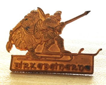
Decorative object - Birkebeiner Lodge Pin
This lapel pin originates from the Birkebeiner Lodge in Norway. The cross country ski race which originated there in 1932 was the inspiration for the annual Kangaroo Hoppet Race held in Falls Creek, Victoria. The Kangaroo Hoppet is Australia's premier long distance cross country ski race, and a member of the prestigious Worldloppet series of international cross country ski events. The first race at Falls Creek was held in 1979 under the name of “Australian Birkebeiner”. The course started and finished at the alpine ski village of Falls Creek, and took participants out into the wilderness area of the Bogong High Plains. Later, 42km became the main distance and after a few name changes, the name of Kangaroo Hoppet was adopted in 1990. The lapel pin was owned and donated by Diana Patterson who was a talented cross country skier. She was born in Tasmania and originally pursued a career as a physical education teacher. After making a major career change, she applied to join the Australian Antarctic Division. She applied four times before she was accepted. Diana first travelled to the Antarctic in October 1987. By this time only ten Australian women had spent a winter there. She first worked at Casey Station, before becoming leader at Mawson Station therein becoming the first female leader of an Antarctic base of any nation. After retiring Diana guided tourist expeditions to the Antarctic for many years, as well as continuing work in research and conservation. In 2012 she published her story “The Ice Beneath My Feet: My Year In Antarctica”. Diana Patterson was awarded the Medal of the Order of Australia (OAM) for "service to conservation and the environment”. As well as these outstanding career achievements, Diana has been a Board Member of both the Mt. Buller Alpine Resort Management Board, including a period as Chairman, and also the Falls Creek Resort Management Board. She was also a founding member of Falls Creek Historical Society.This medal belonged to a highly recognised Australian and founding member of the Falls Creek Historical Society.A small gold lapel pin from the Birkebeiner Lodge in the form of a Nordic skier with the name beneath it.diana patterson, falls creek, cross country skiing, kangaroo hoppet