Showing 110202 items matching "roads"
-
 Melbourne Tram Museum
Slide - Advertising tram W7 1024 East Malvern, Warren Doubleday, 30-10-1971
Photograph of Advertising tram W7 1024, painted for Dulux paints in Waverley Road, East Malvern, route 3 to the City. In the background is G N Hendy fibrous plaster manufacturing works. Photo dated 30-10-1971Yields information about the use of advertising tram 1024.Kodachrome cardboard mounted slide.tramways, tramcars, w7 class, advertising trams, tram 1024, east malvern, waverley rd -
 Bialik College
Mixed media (item) - Oversized items from Kipen files, 1970s, c. 1970s
Oversized items from Kipen files, c. 1970s. Includes a photograph of students, correspondence regarding the opening of the Wantirna campus, newspaper articles and plans of the Auburn Road campus. Please contact [email protected] to request access to this record. -
 Eltham District Historical Society Inc
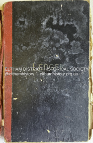
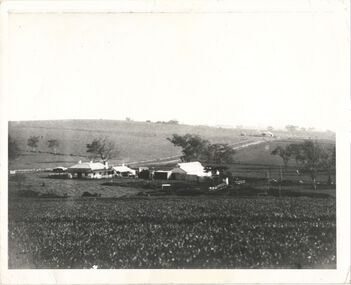
Book - Farm Ledger, Palmer Farm, Cassells Road, Research, Vic, 1912-1923
The Palmer farm was on Cassells Road and consisted of 100 acres extending to present-day Eltham College ovals. It was sold in the 1940s but 10 acres was retained. The Palmer family moved there circa 1910 The ledger covers the period 1912-1923. palmer family, palmer farm, cassells road, research (vic.) -
 Melbourne Tram Museum
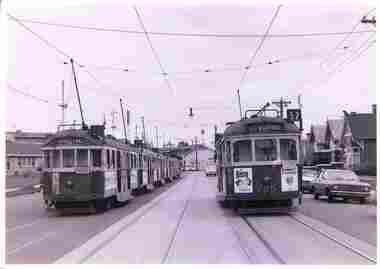
Photograph - Showgrounds parking loop - Union Road, mid 1970s
Photograph shows 6 trams parked in the Showgrounds Loop in Union Road Ascot Vale. W2 class tram 342 is the last parked while W5 class tram 795 is north bound to West Maribyrnong on route 57. Yields information about the use of the Showgrounds Parking or stabling loop mid 1970s.Black and White Photograph with a plain back.tramways, trams, w2 class, w5 class, tram 342, tram 795, union road, ascot vale, showgrounds -
 Sunbury Family History and Heritage Society Inc.
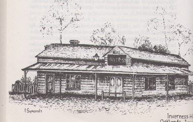
Artwork, other, Ian Symonds, Inverness Hotel
The building is a black and white drawing by Ian Symonds of the former Inverness Hotel, which was sited at the intersection of the Old Bulla and Oaklands Roads. The hotel was demolished when the land was included in the boundary of Melbourne Airport and is now part of the main runway.The Inverness Hotel was open of the first hotels be built along the Bulla Road. A photograph of a black and white drawing of an old hotel buildingI. Symondsinverness hotel, ian symonds, melbourne airport, hotels -
 Bendigo Military Museum
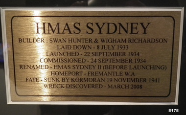
Photograph - HMAS SYDNEY, FRAMED, Unknown
As per the explanation the HMAS Sydney II was launched in Sept 1934, sunk by the German Raider Kormoran on 19 November 1941, the wreck was discovered in March 2008. This item is on display inn the Bistro area of the Bendigo DRSL in Havilah RoadPhotos framed, the frame is timber Brown colour, at the top is the main photo of the ships crew on the decking of the HMAS Sydney II, centre is an explanation of the “Sydney’s building, commissioning and fate, at bottom LH side shows the “Sydney” at sea, the RH photo shows “Sydney” in front of the Sydney Harbour Bridge“HMAS SYDNEY”brsl, smirsl, bdrslinc -
 Eltham District Historical Society Inc
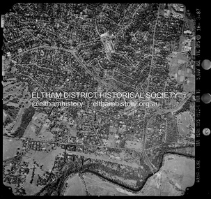
Photograph - Aerial Photograph, Landata, Eltham / Research, Vic, Jan. 1951
Centred on Brinkkotter Road opposite Yarramie Reserve, Eltham bounded by Maroondah Aqueduct to north, Nyora Road to south, Eltham College to east and Leane Drive to west. Historic Aerial Imagery Source: Landata.vic.gov.au Aerial Photo Details: Project No :65 Project : MELBOURNE AND METROPOLITAN PROJECT NO. 2 Run : 7 Frame : 8 Date : 01/1951 Film Type : B/W Camera : EAG9 Flying Height : 12200 Scale : 12000 Film Number : 1419 GDA2020 : 37°42'32"S, 145°10'41"E MGA2020 : 339408, 5824924 (55) Melways : 22 F3 (ed. 42)Historical aerial photos and photo maps provide viusal evidence of the chronology of changes to the built landscape of the district and assist in dating other imagesaerial photo, 1951-01, eltham, neil webster collection, brinkkotter road, eltham college, leane drive, maroondah aqueduct, melways 22f3, nyora road, yarramie reserve -
 Eltham District Historical Society Inc
Photograph - Aerial Photograph, Landata, Montmorency, Feb. 1956
Centred on present day Tahlee Place Reserve and Sherbourne Preschool, Montmorency bounded by Progress Road to north, Withers Way to south, Main Road to east and Leach Street to west. Historic Aerial Imagery Source: Landata.vic.gov.au Aerial Photo Details: Project No :250 Project : MELBOURNE OUTER SUBURBS PROJECT Run : 17 Frame : 114 Date : 02/1956 Film Type : B/W Camera : EAG9 Flying Height : 10000 Scale : 12000 Film Number : 1176 GDA2020 : 37°42'50"S, 145°08'02"E MGA2020 : 335512, 5824286 (55) Melways : 21 F5 (ed. 42)aerial photo, 1956-02, neil webster collection, central park, eltham, leach street, main road, melway 21f5, montmorency, progress road, withers way, sherbourne preschool, tahlee place reserve -
 Eltham District Historical Society Inc
Photograph - Aerial Photograph, Landata, Eltham, Vic, Apr. 1963
Centred on present day Eltham Ridge, Bolton Street, Eltham bounded by Elsa Court to north, Main Road to south, Bible Street to east and Reichelt Avenue and Rattray Road to west. Historic Aerial Imagery Source: Landata.vic.gov.au Aerial Photo Details: Project No :486 Project : MELBOURNE (1963) PROJECT Run : 6 Frame : 124 Date : 04/1963 Film Type : B/W Camera : RC8 Flying Height : 5100 Scale : 9600 Film Number : 1805 GDA2020 : 37°43'12"S, 145°08'16"E MGA2020 : 335876, 5823604 (55) Melways : 21 G6 (ed. 42)aerial photo, neil webster collection, 1963-04, bible street, bolton street, eltham, eltham ridge, main road, montmorency, rattray road, reichelt avenue -
 Eltham District Historical Society Inc
Photograph - Aerial Photograph, Landata, Eltham, Vic, Apr. 1972
Centred on present day Woodridge Estate, Eltham bounded by Park Road to north, Mount Pleasant Road to south, Stokes Orchard Estate to east and Eltham Railway Station to west. Historic Aerial Imagery Source: Landata.vic.gov.au Aerial Photo Details: Project No :985 Project : MELBOURNE 1972 Run : 27 Frame : 46 Date : 04/1972 Film Type : B/W Camera : RC10 Flying Height : 5700 Scale : 9600 Film Number : 2636 GDA2020 : 37°42'49"S, 145°09'46"E MGA2020 : 338053, 5824365 (55) Melways : 22 C5 (ed. 42)aerial photo, neil webster collection, 1972-04, eltham, eltham railway station, melway 22c5, mount pleasant road, park road, stokes orchard estate, woodridge estate -
 Eltham District Historical Society Inc
Photograph - Sepia Print, Unidentified hall; possibly the Montmorency Presbyterian Church Hall, Rattray Road, Greensborough, c.1918
From Eltham Montmorency Uniting Church, History http://www.elthammontmorencyuca.org/history/ In 1914 a small group of Presbyterians living on 'The Montmorency Estate', which had been established when the railway was extended to Eltham several years before, began meeting for worship in the Rattray Rd home of Robert Sharpe. Two years later a small weatherboard church, administered from Scots Church, Heidelberg, was built on land donated by Mr. Sharpe. In 1931 this building was moved to the corner of Rattray Road and Mountain View Roads. In the next few years local elders were elected and the congregation adopted the name St. Andrew’s Presbyterian Church, Montmorency.montmorency, montmorency presbyterian church hall, rattray road -
Glen Eira Historical Society
Letter - Crotonhurst
A letter from Mrs M Ring to the Caulfield Historical Society, dated 14/03/1986, conveying gratitude for the information provided about the house Crotonhurst located at the corner of Hawthorn Road and Glen Eira Road, Caulfield North, and requesting information about the Langdon and Webb families and the property Lirrewa. Enclosed with the letter is a copy of a two page report on the Life of George Frederick Webb. The file also includes a seven page report conducted by Irene Victoria Anderson in 1982 on the history of the Langdon and Webb families and the house Crotonhurst. Two earlier drafts of the same report are included and one of these has further handwritten notes.crotonhurst, rosecraddock, lirrewa, caulfield north, hawthorn road, langdon road, glen eira road, mitchell road, crotonhurst avenue, caulfield city hall, city of caulfield, polo ground, polo parade, neerim road, powderham road, walworth avenue, langdon family, webb family, rosecraddock family, webb george henry frederick, webb george henry webb justice, field matilda, agg sophia sarah, agg sophia sarah annie, webb sophie sarah annie, agg dottie, webb dottie, langdon william farrar, langdon willie, langdon bill, langdon h j mrs, langdon mrs, webb george edward, webb matilda elizabeth, webb isabella elizabeth, webb james hemming, murray peter r, wells john c, langdon marie, langdon clive, murdoch keith, egerton-warburton mr, yorston mr, yorston rita, langdon violet, langdon. philip, gillespie ray, lindsay joan, ring m, paterson mrs, coffey eileen, fitzsimmons eileen, ronald heather, william gluyas, maidment isobel, langdon rr, langdon charles, langdon r b, knox david, langdon dick, hart trevor, mclaughlin j, ballantyne r, webb matilda sarah, somers charles, mckenzie barbara, mcleod lexie, richards barbara, richards lexie, sims betty, anderson irene victoria, short hand writer, lawyers, phthisis, queen’s counsel, judge of the supreme court, court reporter, architectural features, world war 1914-1918, soldiers, point to point steeplechase, master of the hounds, organs, sculptor, statues, stained glass, crests and emblems, elsternwick congregational church, government shorthand writers’ department, eureka treason trials, swamp sand and heath, dickson and yorston, caulfield council, caulfield historical society, harrison ramsay, time without clocks, the hounds are running, melbourne hunt club, st mary’s church, geo. fincham and sons, city hall gallery, mansions -
 Victoria Police Museum
Police Stations (Anglesea)
Anglesea is a town on the Great Ocean Road in the Surf Coast Shire local government area. It is 110km from Melbourne. Before 1967 policing in Anglesea was on a seasonal basis with a 'shop front' police station and caravan in the main street. Anglesea Police Station (Barwon District) was opened on 7 February 1967 on the corner of Wray Street and The Great Ocean Road. It was a residential police station, brick veneer with an iron roof with 3 rooms, a bathroom, laundry and a garage. When the station opened it was staffed by one Senior Constable and two First Constables. List of staff from 1967-2002 is available from Victoria Police Museum10 photographs comprising: 8 black and white photos, 2 colour photospolice stations; anglesea police station -
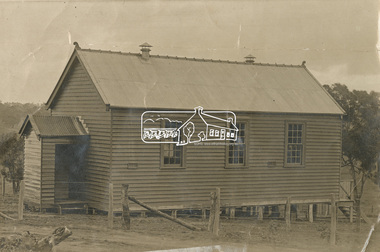
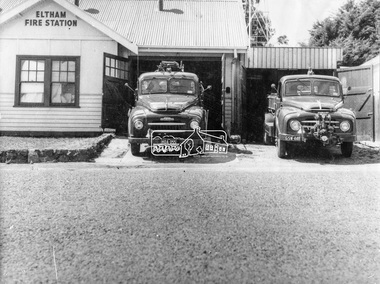 Eltham District Historical Society Inc
Photograph, George W. Bell, Eltham Fire Station, east side of Main Road, c.Jan 1964
The photograph was taken (and donated) by George W. Bell during the period of fire, c.1963-c.1964. The actual fire station was built c.1930 and was in use till c.1964 when a new fire station was built on the opposite side of Main Road. The building, originally situated just south of Arthur Street, on Main Road was ultimately relocated in 1970 to Research Park for use by the 1st Research Scout group. The site is now part of the current Coles supermarket and Eltham Village complex. The Fire Trucks are an Austin STU (small town unit) on the left and an Austin urban pumper on the right. This photo forms part of a collection of photographs gathered by the Shire of Eltham for their centenary project book,"Pioneers and Painters: 100 years of the Shire of Eltham" by Alan Marshall (1971). The collection of over 500 images is held in partnership between Eltham District Historical Society and Yarra Plenty Regional Library (Eltham Library) and is now formally known as 'The Shire of Eltham Pioneers Photograph Collection.' It is significant in being the first community sourced collection representing the places and people of the Shire's first one hundred years.Digital imageaustin stu fire truck, austin urban pumper, eltham, eltham fire brigade, fire station, fire truck, george w. bell, motor vehicles, shire of eltham pioneers photograph collection -
 Orbost & District Historical Society
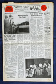
newspaper, Snowy River Mail, 1.12.1976
In early 1974, as an Engineer with the Country Roads Board, David came to Orbost as the Supervising Engineer for the construction of the new bridges which were part of an 8.4km Orbost bypass road design. This was a major project involving not only a new bridge over the Snowy River (including Lochiel Lagoon), but other bridges over Ashby’s Gulch and Watt’s Gulch. These new bridges were opened in November 1976 with the unveiling of a plaque on the eastern end of the $2.4M Snowy River Bridge. The new bridge, built by the CRB at a cost of $2.4 million, is 1.6 metres above the record flood levels of 1971. (ref. May Leatch) This newspaper contains contemporary reports of a significant event in Orbost.A Snowy River Mail newspaper, dated 1.12.1976. It contains news articles, photographs and advertisements. The main article relates to the official opening of the Snowy River Bridge and the unveiling of a plaque on the eastern approach. It also contains a history of the first Snowy River Bridge.snowy-river-bridge orbost-bridges snowy-river-mail -
Glen Eira Historical Society
Document - Petrov, Vladimir and Evdokia
Three items concerning Vladimir and Evdokia Petrov, Russian spies who defected to Australia in 1954 and who lived in East Bentleigh as Sven Gustav Allyson and Maria Anna Allyson. Two copies of an article in The Melbourne Weekly Bayside, May 12-18, 2004. Includes a photo of the couple and their East Bentleigh house. A print out from a real estate website showing a photo of the house at 96 Parkmore Road Bentleigh East with handwritten notes Handwritten note regarding Sands and McDougall, Directory of Victoria 1960 which lists S.G. Allyson living at 96 Parkmore Road, Bentleigh Eastbentleigh east, petrov vladimir, petrov evdokia, allyson sven gustav, allyson maria anna, russia, asio, kgb, political parties, parkmore road -
 Kew Historical Society Inc
Photograph, Kilby Farm, Kew East
Kilby Lodge (c.1845-c.1922). William Oswin purchased Crown Land Lots 52 & 53 in 1845. These lots ran north from an old bullock track [later Kilby Road] to the Yarra, and east to Burke Road. Oswin purchased a neighbouring Lot in 1851, separated by the bullock track from the rest of the farm. Oswin built ‘Kilby Lodge’ and, with his brother, farmed dairy cattle on the site. Oswin’s descendants owned the farm into the 1890s. New subdivisions of Kilby and neighbouring farms in the 1920s changed the rural nature of north Kew. Housing and large recreation reserves replaced dairy farms and market gardens. This work forms part of the collection assembled by the historian Dorothy Rogers, that was donated to the Kew Historical Society by her son John Rogers in 2015. The manuscripts, photographs, maps, and documents were sourced by her from both family and local collections or produced as references for her print publications. Many were directly used by Rogers in writing ‘Lovely Old Homes of Kew’ (1961) and 'A History of Kew' (1973), or the numerous articles on local history that she produced for suburban newspapers. Most of the photographs in the collection include detailed annotations in her hand. The Rogers Collection provides a comprehensive insight into the working habits of a historian in the 1960s and 1970s. Together it forms the largest privately-donated collection within the archives of the Kew Historical Society.A panoramic photograph of Kilby (or Oswin's) Farm in East Kew."Kilby Farm when Oswins owned it. Commenced 1845."kilby farm, kilby lodge, william oswin, dorothy rogers, kew east -
 Kew Historical Society Inc
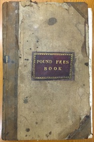
Administrative record (item), Borough of Kew, Pound Fees Book, 1874-1896
While the first successful land sales in Boroondara occurred in Hawthorn in 1843, and Kew in 1845, these areas were to be without local pounds until April 1858, when the Governor of Victoria, in accordance with Act 18 Victoria No 30, was pleased to direct the establishment of a Pound at Glass’s Creek on that part of land bounded by the Kilby Road, Burke Road and High Street. While the Governor was required to proclaim the establishment of a pound, the appointment of a poundkeeper was the responsibility of the Justices of the Peace in the local Court of Petty Sessions. The Pound took its name from the most distinctive natural feature of the area, Glass’s Creek, named after the early pastoralist Thomas Glass.The register is of historic significance as an indicator of suburban life in the second half of the 19th Century. It shows how farming and city life on the urban fringe were intimately connected. It is also significant to the early history of Hawthorn and Kew, who both claimed the Pound following their separation from the Boroondara Roads Board in 1861."Kew Pound Book"glass creek pound (kew), animal pound, dog pound, kew pound, j. smith, john oakes, samuel b. cash, edward s. delaney, emma oswin, samuel cash -
 Eltham District Historical Society Inc
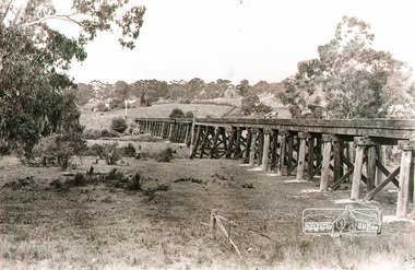
Photograph, Rural view of trestle Bridge, Eltham, c.1912
The railway was commenced in 1900 and passed through the middle of the Shillinglaw farm. The line to Eltham opened in 1902. This view shows the the new Catholic Church, St Mary's in Henry Street (near Main Road, then Maria Street) and Shillinglaw Cottage visible in background past where Eltham Town Park and later the Eltham library (1994) was built. The church site had been relocated from further south along Main Road (near Wingrove Cottage) in order to be more central to the congregation following the shifting of the township away from Little Eltham and closer to the railway station. It was subsequently destroyed by fire in 1961.Black and white photographeltham, trestle bridge, bridges, catholic church, henry street, bridge, shillinglaw cottage, shillinglaw trees, shillinglaw farm -
 Eltham District Historical Society Inc
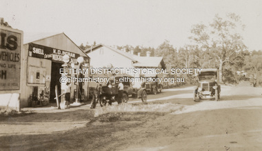
Photograph, K.D. Ingram's Shell Garage, Research, Vic, c.1930
The inscription on the back of the photo incorrectly states the garage is at Anglesea. It is in fact at Research, Victoria. Kenneth Douglas Ingram moved from Research to his holiday home at 9 Minifie Avenue, Anglesea between 1943-1949. He established a new garage at Anglesea which was a concrete block design building, not a tin shed as this at Research. This garage was located between the family home and the public hall at Research on the original line of Main Road. The public hall site is now the site of the Eltham Little Theatre. The family home, a red brick building still stands today (2023) at 1591 Main Road, ResearchOn reverse "Garage, Anglesea"k.d. ingram shell garage, kenneth douglas ingram, main road, pam thoonen (nee ingram) collection, research (vic.), research garage -
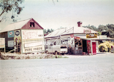 Eltham District Historical Society Inc
Photograph, Doney's General Store, Research, c.1969
Roadside buildings, formerly Doney's General Store. Doney's operated from the 1880s through to the late 1960s. It was situated at the head of the present day Research shops on Main Road near the corner of Raglan Road. By the 1960s it was under new ownership. The Store had a residence at the back. Signs promote The Herald and Sun newspapers, four 'n twenty pies, coca cola and more. A public phone box is in the front of the store. Beside the store is possibly an old farm building with more signs advertising honey, Streets, Tarax and a local bottle dump. Lyn Dodkins used to work in the Store after school.Digital file onlygeneral store, research (vic.), milkbar, lyn dodkins -
 Ballarat Tramway Museum
Photograph - Set of four black and white negatives of Ballarat trams, Warren Doubleday, 20-4-1968
Photos 25-4-69, of: .1 - Ballarat 17 at Stones Corner with Caltex Service Station in the background. Tram leaving Main Road before joining Bridge St. .2 - No. 28 running from Bridge Street into Sturt Street with a "Trotting at Bray Raceway Tonight" Auxillary board. Tram has the destination of Gardens via Sturt St West. In the background are the Big W and the Dickins Store. .3 - Tram 43 on "0" road at the SEC Ballarat Depot. .4 - Tram 13 at the Gardens Loop in Wendouree Parade. Tram has an ANA Hospital and Medical Benefits (Australian Natives Association) Advertising Board.Yields information about the operation of the Ballarat tramway system that was operated by the State Electricity Commission of Victoria.Set of four black and white negatives of Ballarat Tramways, 120 size. ballarat, trams, tramways, sturt street, tram 17, main road, bridge street, tram 28, bray raceway, dickins, big w, tram 13, ana health, wendouree parade, gardens loop, depot, tram 43, stones corner, caltex -
 Melbourne Tram Museum
Negative - Tram 184 - Epsom Road level crossing, early 1920s
Black and white photograph of M class tram 184 crossing the Epsom Road, Flemington level crossing. Shows the overhead arrangement and structures on either side of the road to provide power to either the trams or the trains. The small signal box is in the view as well as the hand gates. In the background is the roof of another tram going the other way. The level crossing was electrified on 18-8-1919 and abolished in mid-1925 when the underpass was built. See Weekly Notice Extracts 1894-1994, published 1996. The tram was sold to the SEC in 1935 and became Ballarat No. 31. See item 3433 for a similar photo with an NMETL tram.Yields information about the Epsom Road level crossing and tram 184.Black and white copy negative.trams, tramways, mmtb, level crossings, epsom rd, show grounds, ascot vale, m class, tram 184 -
 Eltham District Historical Society Inc
Photograph - Aerial Photograph, Landata, Montmorency / Lower Plenty, Jan. 1962
Centred on 147 Old Eltham Road, Lower Plenty bounded by Hurstbridge Railway Line to north, Yarra River to south, Main Road, Eltham to east and Heidelberg Golf Club to west. Historic Aerial Imagery Source: Landata.vic.gov.au Aerial Photo Details: Project No : 539 Project : MELBOURNE-GEELONG PROJECT Run : 6 Frame : 81 Date : 01/1962 Film Type : B/W Camera : RC5 Flying Height : 6000 Scale : 15840 Film Number : 1524 GDA2020 : 37°43'52"S, 145°07'26"E MGA2020 : 334685, 5822354 (55) Melways : 21 D9 (ed. 42)aerial photo, lower plenty, main road, montmorency, phoebe mason collection, eltham, eltham lower park, heidelberg golf club, hurstbridge railway line, main road eltham, yarra river -
 Eltham District Historical Society Inc
Photograph - Aerial Photograph, Landata, Montmorency / Lower Plenty, Mar. 1987
Centred on 354-356 Main Road, Lower Plenty bounded by Rattray Road, Montmorency to north, Yarra River to south, Falkiner Street, Eltham to east and Lower Plenty shops to west. Historic Aerial Imagery Source: Landata.vic.gov.au Aerial Photo Details: Project No :1716 Project : WESTERN PORT FORESHORES Run : 16 Frame : 132 Date : 03/1987 Film Type : B/W Camera : RC10 Flying Height : 5600 Scale : 10000 Film Number : 4102 GDA2020 : 37°43'51"S, 145°07'38"E MGA2020 : 334968, 5822406 (55) Melways : 21 E9 (ed. 42)aerial photo, lower plenty, main road, montmorency, phoebe mason collection, eltham, eltham lower park, falkiner street, lower plenty shops, main road eltham, rattray road, yarra river -
 Melbourne Tram Museum
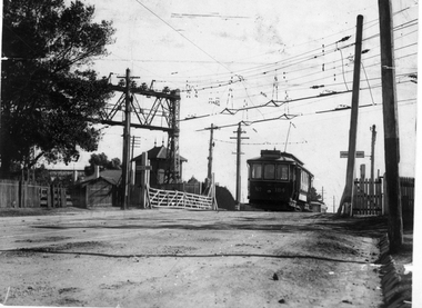
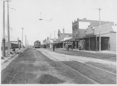
Photograph - Fitzroy, Northcote & Preston Tramways Trust car number 1 in Plenty Road, early 1920s
Photograph of Fitzroy, Northcote & Preston Tramways Trust (FNPTT) R class tramcar No.1 northbound on single track in Plenty Road, Preston approaching a double track loop south of Bell Street. The photograph looks southward showing an unsealed road surface with a few horse drawn carts, span poles and overhead wires, tramways overhead light above loop turnout and low density shop fronts. While this tramcar and track were constructed for the FNPTT, the line was only operated by the Melbourne and Metropolitan Tramways Board from 1920. This car would soon be renumbered 151 and relocated to other lines Melbourne.Yields information about commencement of the Preston tram line and the Fitzroy, Northcote & Preston Tramways Trust. Black and white photograph with nothing on rearfnptt, r class, plenty road, preston, span poles, track loop, melbourne and metropolitan tramways board, fnptt number 1, tram number 151 -
 Mt Dandenong & District Historical Society Inc.
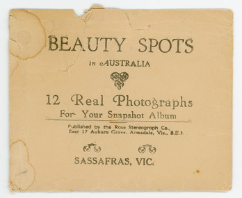
Photograph, Beauty Spots in Australia. Sassafras, c1913
This set of small photographs was produced by the Rose Stenograph Co. c1913 to be included in photograph albums. The area known as South Sassafras, was opened up for settlement in 1893 and the name was changed to Kallista in 1925.A small, paper envelope containing 12 photographs of Sassafras that are reproductions of Rose Series postcards. There are 10 different photographs, 32a and 32c have doubles.Envelope : BEAUTY SPOTS in AUSTRALIA 12 Real Photographs For Your Snapshot Album Published by the Rose Stenograph Co. Rear 17 Auburn Grove, Armadale, Vic 3.E.3 SASSAFRAS, VICTORIA Photograph 32a - THE ROSE SERIES P. 905 CLEMATIS AVENUE, SHERBROOKE, VIC. Photograph 32b - THE ROSE SERIES P. 1603 THE CASCADES, SASSAFRAS, VIC. Photograph 32c - THE ROSE SERIES P. 204 PANORAMA AT SASSAFRAS, VIC. Photograph 32d - THE ROSE SERIES P. 4046 MAIN ROAD, SASSAFRAS, VIC. Photograph 32e - THE ROSE SERIES P. 1502 SASSAFRAS CREEK, SASSAFRAS, VIC. Photograph 32f - THE ROSE SERIES P. 1501 TOURIST TRACK, SASSAFRAS, VIC. Photograph 32g - THE ROSE SERIES P. 4244 TOURIST TRACK, SOUTH SASSAFRAS, VIC. Photograph 32h - THE ROSE SERIES P. 2725 CLEMATIS AVENUE, SHERBROOKE, VIC. Photograph 32i - MAIN ROAD, SASSAFRAS, VIC. Photograph 32j - THE OLINDA - SASSAFRAS ROAD, VIC. rose series, rose series, sassafras, sherbrooke, sassafras creek -
Glen Eira Historical Society
Document - Hawthorn Road, 284, Caulfield
Report dated 02/05/1988 about 284 Hawthorn Road, Caulfield by the Brighton Historical Society. It provides a history of this site from 1852 to 1974 including tenants and owners from 1923 to 1974. Handwritten working notes are included.hawthorn road, caulfield, mill road, maxwell nellie, glen john, stevens gar, watson george v.e., niblett thomas a., johnson stanley, williams millie, crawford walter h., usher gordon r., paton m.h. mrs., marriot, murray s., land sales, land subdivision, migrants, houses, tram services, bullock h. miss, landells r. miss -
Glen Eira Historical Society
Document - Hawthorn Road, 377, Caulfield
Valuation report dated 29/11/1965 for 377 Hawthorn Road Caulfield detailing land, improvements and general comments together with marked and rental values. This is a carbon copy with bottom of first page cropped and therefore is missing some lines.hawthorn road, caulfield, land use, factories, bakeries, bricks, rents and renting -
Glen Eira Historical Society
Article - Koornang Road, 51, Carnegie
A colour newspaper article identified as from the Property Review Weekly and dated 22/11/02, advertising the forthcoming auction of the dwelling and shop at 51 Koornang Road on 05/12/2002. The article includes a colour photograph of the building exterior.shops, carnegie, koornang road, carnegie railway station, auctions