Showing 1672 items
matching concreting
-
 Puffing Billy Railway
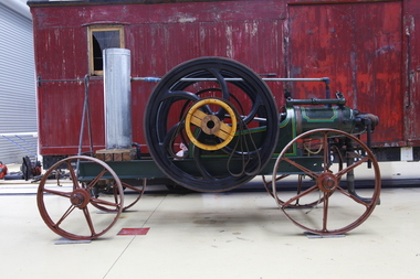
Blackstone Oil Engine, 6 November 1908
8HP Blackstone Lamps Start Oil Engine engine number 71076 Engine Details Maximum operating RPM of 240. Fitted with a 3'9" Flywheel Tested on the 6th of November 1908. Shipped to Cluter buck South Australia for installation on concrete base. Recovered and restored during the 80's in South Australia Purchased privately in 2013 in Tailem Bend South Australia and transported to Victoria. Currently on loan to the Puffing Billy Museum at Menzies Creek as an operating exhibit. Blackstone & Co. was a farm implement maker at Stamford, Lincolnshire, United Kingdom. In 1896 they built lamp start oil engines. The Lamp or hot-bulb engine (also hotbulb or heavy-oil engine) is a type of internal combustion engine. It is an engine in which fuel is ignited by being brought into contact with a red-hot metal surface inside a bulb, followed by the introduction of air (oxygen) compressed into the hot-bulb chamber by the rising piston. There is some ignition when the fuel is introduced, but it quickly uses up the available oxygen in the bulb. Vigorous ignition takes place only when sufficient oxygen is supplied to the hot-bulb chamber on the compression stroke of the engine. Most hot-bulb engines were produced as one-cylinder, low-speed two-stroke crankcase scavenged units Historic - Industrial - single cylinder, horizontal, 4 stroke, hot-bulb ignition oil engine Blackstone 8HP Oil Engine made from steel, wrought iron and brassOval Plate with Black Stones and Clutter Buck Brass Plaque engine number 71076blackstone, oil engine, clutter buck, black stone, puffing billy, hit and miss, engine, blackstone & co -
 Melbourne Water
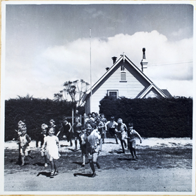
Photograph, North Cocoroc State Primary School, 1950s
As the Yarra became unsuitable as a source of water, several attempts were made to find alternative sources for the growing population of Melbourne. It was not until 1891 that the efforts to sewer Melbourne came to fruition with the setting up of the Melbourne Metropolitan Board of Works (MMBW), now known as Melbourne Water. From 1891 until 1992, it was the responsibility of the MMBW to safeguard public health by providing a sewerage system and a safe water supply system. In 1992, The MMBW merged with a number of smaller urban water authorities to form Melbourne Water. The township of Cocoroc was created in 1894 at the Metropolitan Sewage Farm (now the Western Treatment Plant) to house the workers it employed. The name 'Cocoroc' means 'frog' in the language of the Wathaurung people — the Traditional Owners of the land the treatment plant was built on. By the early 1950s there were nearly 100 houses, a town hall, football ground (and team), swimming pool, tennis courts, four schools and a post office, and by the 1970s some 500 people were living in Cocoroc. As it became too expensive for the MMBW to subsidise, Cocoroc was abandoned. By 1973 most of the houses and other buildings were demolished or moved to Werribee. All that is left now of Cocoroc are two small, empty, concrete swimming pools, a few weatherboard sheds and a big iron water tank. This photograph detailing an exterior view of the North Cocoroc State Primary School, is historically significant as it captures children at play within a purpose built community. The School that was one of four was built to educate the children of the MMBW workers. As the school no longer exists, this photograph is the only tangible evidence left of the building, also showcasing the style of buildings in this era. cocoroc, township, school, mmbw, melbourne metropolitan board of works, melbourne water -
 Melton City Libraries
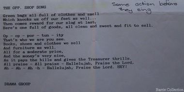
Document, The opp. shop song, Unknown
SUMMARY – Uniting Church Op Shop Melton South Opportunity Shop – Brooklyn Road Melton South Est 1975 Former Methodist Church. The Opportunity Shop – Established 1975 by Edna Barrie 1992 Typed copy by Cath MacLean 2011 [Scots’ Presbyterian Church 1964] Additional information to the above summarised from Edna Barrie’s draft notes. Copied by Wendy Barrie January 2012, noting the information might be useful for future research. In 1985 the need for more shop space became apparent. Les [Bone] had plans drawn up (Surv 12/8/84) and approved by the Melton shire Council for a storeroom extension (17.800 x 9500) 1986 the small ancillary rooms at the rear of the timber church were demolished allowing the concrete slab to be laid. The building was completed in 1987. By the early 1990s the old timber Church had deteriorated, this lead to it being demolished in 2/11/1993. It was replaced with a new building containing a Pastoral Office, a meeting room and a furniture and homeware section. It was dedicated by Rev Ian Hickingbotham at 11am Sunday 5th June 1994. Service Awards were presented to 75 Opportunity Shop Volunteers by Rev Ian Hickingbotham. Funds have helped to pay for pastoral work, youth work and extra pastoral support. Lyrics for the Opportunity Shop which was located at the former Methodist Church. council, churches, local identities -
 Parks Victoria - Gabo Island Lightstation
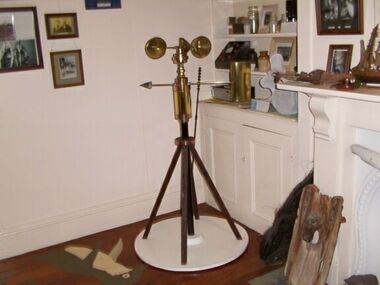
Anemometer
This device was used to measure surface wind speed and direction. This anemometer was located on a concrete pad outside room 2.15 on a steel pole. The pole was considered unsafe and the anemometer was relocated to it's current position. When lowering the pole it fell over and was badly damaged. The Bureau of Meteorology donated it to the museum. It was then repaired and restored. The central pole on which it is mounted is galvanised iron pipe painted black. The anemometer, a portable device that manually measures wind speed, was a necessary instrument once common to all weather stations. The arms are attached to a vertical rod and as the wind blows, the cups rotate, making the rod spin. The stronger the wind blows, the faster the rod spins. The anemometer counts the number of rotations, or turns, which is used to calculate wind speed, surface wind and direction. They were designed to be durable to withstand the corrosive environment and strong winds expected at coastal sites such as those at Gabo Island. Anemometers existed in the nineteenth century and their design was improved by various experts including John Robinson in 1846, John Patterson in 1926, Brevoort and Joiner in 1935 and Derek Watson in 1991 who added wind direction measurement to its functions. This example was made for the Bureau of Meteorology by the Melbourne instrument company, Synchrotac, which became registered and incorporated on 26 July 1966. It is now displayed inside the building. A good example of its kind, the anemometer has first level contributory significance for its historic value and provenance to the lightstation.Anemometer and tripod stand. Three cupped brass discs on rotating arms fixed to turned brass cylinder shaped shaft. Beneath discs is a lead directional wind arrow attached to a rotating arm. A wooden three legged stand with central supporting pole of black painted hardwood and attached to a white painted marine ply circular base.Under wind cups: " SYNCHROTAC / MELB. / ser.no.70/372 / MADE IN AUSTRALIA." Above wind direction arrow: "C.OF.APT..../ SYNCHROTAC / MELB ? MADE IN AUSTRALIA / ser.no.70/372" -
 Parks Victoria - Gabo Island Lightstation
Insulator
Modern communication technologyarrived on gabo Island with the construction of the telegraph line from Eden to Gabo Island in 1870. The insulator is associated with the telegraph station. Used at the H.F Radio Beacon. The items of telegraphic equipment comprise a number of ceramic and glass insulators of varying age and type. In addition to insulators, there is a telephone insulator bracket made of metal with wooden pins. It was once attached to the top of a steel pole and some of these remain in situ along the former telegraph line (0044). Telegraphic communication commenced at the Gabo Lightstation in 1870, just eight years after the lightstation opened. The line from Sydney reached Eden, NSW by 1868 and was then extended to Gabo with the costs shared equally by NSW and Victoria. It was initially carried on posts across the sea to the island but was changed to a line along the seabed after the posts were washed away. The first telegraph office was a timber building on east side of the assistants’ quarters. In 1887 a new concrete telegraph office was built which included quarters for the operator, with Victoria and NSW sharing the construction costs. The 1992 CMP identified remnants of the line from its various phases of operation,and these were seen in 2016. Other ceramic insulators in the collection are associated with lines supported on utility poles for the transmission of high voltage electricity. The various insulators have second level significance for their historic value and provenanceFour armed cross shaped insulator with two holes through diagonally opposite sections. It is ceramic with a clear glaze. -
 Wodonga & District Historical Society Inc
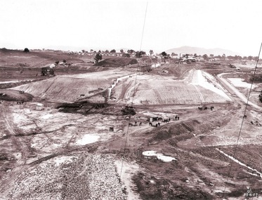
Album - Hume Reservoir Australia Album - Earth embankment on Victorian side from Top of Tail Tower Pillar, August 1927, 1927
This set of photos is from a leather bound album bearing the inscription "HUME RESERVOIR AUSTRALIA" plus 'The Rt. Hon. L. C. M. S. Amery, P. C., M .P.' all inscribed in gold. It was presented to The Rt. Hon. L. C. M. S. Amery, P. C., M. P, Secretary of State for Dominion Affairs on the occasion of his visit to the Hume Reservoir on 2nd November 1927. This album is of local and national significance as it documents the planning and development of the Hume Reservoir up to 1927. It was the largest water reservoir in the British Empire. The album records the pioneering engineering work that went into its construction.DEPARTMENT OF PUBLIC WORKS, N.S.W. RIVER MURRAY WATERS SCHEME. HUME RESERVOIR. 31. View from Top of Tail Tower Pillar - Earth Embankment, Victoria. This is a general view of the embankment which is being constructed by the Victorian Constructing Authority. The bank at its base is about 650 feet wide and it is about half its ultimate height. In the middle is the reinforced concrete core wall. At about the natural surface a tunnel for drainage and inspection purposes is built along the downstream side of the core wall but this cannot be seen. The Victorian workshops and township are located on the high ground beyond the embankment. The embankment curves round to the left at the side of the valley and will eventually block the gulley where the bushy tree stands. Access to one of the cuttings from which material is being got for the embankment is gained by means of this gulley at present. Part of another cutting may be seen on the right hand side at the back. August 1927.hume reservoir australia, river murray waters scheme, hume reservoir construction -
 Ballarat Tramway Museum
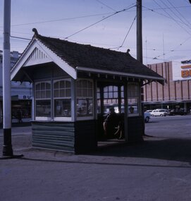
Slide - 27 mm sq slide/s - set of 4 - shelters, Lilian Butler, August or September 1971
Yields information about some of the individual street tramways shelters at tram stops and their appearance.Set of four Colour 27 x 27 mm slide in a Kodachrome cardboard mount. .1 - Grenville St with two ladies sitting inside, has the Big W store in the background. .2 - Concrete shelter with curved roof - Wendouree Parade near - has the photographer's purse and umbrella on the seat. This shelter was located at Forest St. From discussions with Dave Macartney and Alastair Reither 11/9/2016, it was there in the 1990 hail storms as they sheltered under it, but disappeared soon after - the construction of the roundabout would have absorbed its location. .3 - timber based shelter with flat roof - Wendouree Parade near Dowling St. This shelter remains in position in 9/2016. See Reg Item 6551 for a digital image. .4 - Shelter at Tramway Centre, City, Sturt St and Lydiard Sts, looking towards the Town Hall Slide mount date August or September 1971. Photo from the collection of Lilian Butler.ballarat, tramways, trams, shelters, grenville st, wendouree parade, sturt st, lydiard st, city, tramway centre, forest st, dowling st -
 Bendigo Historical Society Inc.
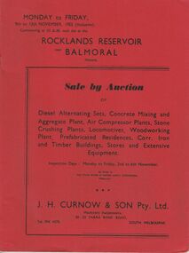
Document - IAN DYETT COLLECTION: AUCTION CATALOGUE - ROCKLANDS RESERVOIR
Red covered catalogue for a Sale by Auction at Rocklands Reservoir near Balmoral, Vic. On the 9th to 13th November, 1953 (inclusive). For sale are Diesel Alternating Sets, Concrete Mixing and Aggregate Plant, Air Compressor Plants, Stone Crushing Plants, Locomotives, Woodworking Plant, Prefabricated Residences, Corr. Iron and Timber Buildings Stores and Extensive Equipment by order of The State Rivers & Water Supply Commission, Melbourne. Pasted in the front of catalogue is a slip to write name, address and phone number on and to give to clerk when making their first purchase. A typed note loose in the front of catalogue mentions that the time for removal of houses and buildings has been increased from four weeks to three months and goods would be at purchaser's own risk after time of sale. Descriptions of some of the items for sale. Catalogue has Ground Plans of the eight different residential houses. J. H. Curnow & Son Pty. Ltd. Were the auctioneers.business, auctioneers, j h curnow & son pty ltd, ian dyett collection - auction catalogue - rocklands reservoir, the state rivers & water supply commission, j h curnow & son pty ltd, balmoral combined women's associations, prahran telegraph printing co -
 Bendigo Historical Society Inc.
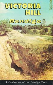
Document - JOAN O'SHEA COLLECTION: VICTORIA HILL GOLDMINING AREA BOOKLET, March 1972
Joan O'Shea Collection. Victoria Hill Bendigo Gold Mining on the Richest Quartz Reef in Bendigo, from 1854 to 1916. Colour and Black and White Booklet 16 Pages. Includes Maps of the Victoria Hill Area, photographs of the remains of a twenty head crushing battery, burnt ground from quartz roasting, The Victoria Quartz Mine Photograph from Australian Mining Standard June 1899, The compressor beds and concrete foundations for the poppet legs all that remain today of the Victoria Quartz Mine deepest mine on Bendigo Goldfield 4613 feet or 1406.04 metres. Also included photograph of the view of Victoria Hill from The New Chum Hill in the 1870s. The Location of the 3 mines Ballerstedt's open cut, North Old Chum and Lansell's 180 are marked. A depiction of Rae's Open Cut gives an understanding of the primitive nature of early workings on the Goldfields. The Booklet also provides a brief history of Victoria Hill itself.Bendigo Trust Publication March 1972. Printed in Bendigo Cambridge Press.bendigo, mining, victoria hill -
 Port Fairy Historical Society Museum and Archives
Photograph
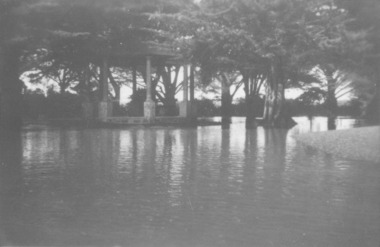
Showing the flood waters of 1946 around the Band Rotunda in the botanical gardens. Funding for the construction of the Rotunda was bequeathed in the Will of local resident Mrs Annie Williams, who was born in Daylesford in 1872 and died in Kew in 1930. Annie’s Will stipulated that the remaining value of her Estate be spent on erecting a Bandstand in the Port Fairy Botanical Gardens dedicated to the memory of her brother Hugh, a stretcher bearer in WW1 and who died in 1921 after being discharged with health issues, her husband Henry, and herself naturally. There is a plaque dedicated to Annie on the Bandstand She requested that the Bandstand be a replica of the one at Daylesford but by 1933 the value of her Estate had diminished to £76.4/8 which was insufficient to cover a similar design and the Borough Councillors felt it would be too extravagant for the Port Fairy Botanical Gardens. Local builder J.J.McLaren’s tender of £71.15/- was accepted and the octagonal concrete pillared construction was completed with the use of sustenance labour the following year. The Bandstand was opened in December, 1934 with a performance by the Port Fairy Band and local residents enjoying the entertainment and a picnic. In 1934 it was reported that there was some fuss in Council because of the whereabouts of the sum of approximately £3/- , being the amount left over from the build. After some months of debate, in which the Councillors suggested that the Engineer had used the money inappropriately, and to which he responded that the build had cost more than the quote, the matter seems to have ended there An image of the flood waters in the botanical gardens in 1946Black and white photograph of Flood water around rotunda in the gardensflood, river, botanical gardens, port fairy, moyne river, rotunda, bandstand -
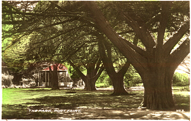
 Port Fairy Historical Society Museum and Archives
Postcard, "The Park", Port Fairy
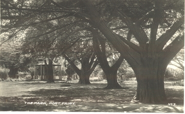
Funding for the construction of the Rotunda was bequeathed in the Will of local resident Mrs Annie Williams, who was born in Daylesford in 1872 and died in Kew in 1930. Annie’s Will stipulated that the remaining value of her Estate be spent on erecting a Bandstand in the Port Fairy Botanical Gardens dedicated to the memory of her brother Hugh, a stretcher bearer in WW1 and who died in 1921 after being discharged with health issues, her husband Henry, and herself naturally. There is a plaque dedicated to Annie on the Bandstand She requested that the Bandstand be a replica of the one at Daylesford but by 1933 the value of her Estate had diminished to £76.4/8 which was insufficient to cover a similar design and the Borough Councillors felt it would be too extravagant for the Port Fairy Botanical Gardens. Local builder J.J.McLaren’s tender of £71.15/- was accepted and the octagonal concrete pillared construction was completed with the use of sustenance labour the following year. The Bandstand was opened in December, 1934 with a performance by the Port Fairy Band and local residents enjoying the entertainment and a picnic. In 1934 it was reported that there was some fuss in Council because of the whereabouts of the sum of approximately £3/- , being the amount left over from the build. After some months of debate, in which the Councillors suggested that the Engineer had used the money inappropriately, and to which he responded that the build had cost more than the quote, the matter seems to have ended there Black and white photograph of the stand of cypress trees with the rotunda in the backgroundThe Park Port Fairy - No 3botanical, garden, trees, rotunda, path -
 City of Warrnambool Rowing Club
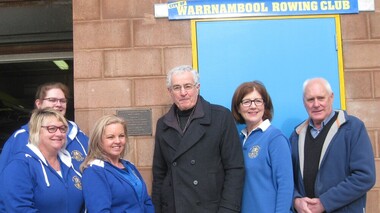
Development Plaque, 16 july 2017
The people are L to R: Kathy McMeel (secretary), Annie Blanch (Boat Captain), Joanne Bone (president), James Tait (director of Gwen and Edna Jones and Ray and Joyce Uebergang Foundations, Susan Finnigan (Grants Officer) and Clive Wooster (treasurer). • In February 2017 the club filled the base of the boathouse and poured a new concrete floor. • They had an opening to thank the donors, especially the Gwen and Edna Jones and Ray and Joyce Uebergang Foundations and to celebrate with the community and rowers, past and present • Since 1996 rowers had to wade in foul, ankle to thigh high water to access the boat shed- this was for 3-5 months of every year- our facilities are now accessible and Warrnambool has a sporting venue for rowers that is safe and one the public can be proud of. • The Club thanked Barry Wilson for generously donating the plans and acknowledged the ‘term deposit’ raised over the last 10 years, by past and present members, which allowed the Club to contribute the additional funding required. • In particular The Foundations assistance made the project possible. The two philanthropic Foundations are a treasure for the community as they can step in and fill the gap where other funding sources cannot. In our case they were the major donors and we could not have contemplated this project without their assistance. We are truly grateful for the assistance of The Gwen and Edna Jones and Ray and Joyce Uebergang Foundation. • Mr James Tait, a director of both Foundations to unveiled the commemorative plaque. Color photograph taken at the opening of the Redeveloped City of Warrnambool Rowing Club. Includes a brass plaque. The people are L to R: Kathy McMeel (secretary), Annie Blanch (Boat Captain), Joanne Bone (president), James Tait (director of Gwen and Edna Jones and Ray and Joyce Uebergang Foundations, Susan Finnigan (Grants Officer) and Clive Wooster (treasurer).james tait, warrnambool, city of warrnambool rowing club, warrnambool rowing club, boathouse, boathouse redevelopment, gwen and edna jones foundation, ray and joyce uebergang foundation -
 Queenscliffe Maritime Museum
Instrument - Barometer and Clock mounted on a timber cabinet and 10 associated items from the TSS Nairana, 1915
Bass Strait passenger ship Nairana. Built for Bass Strait ferry operator Huddart Parker & Co. Ltd. of Melbourne during World War One, the Nairana was requisitioned by the Royal Navy and completed as a seaplane carrier, HMS Nairana. Serving from 1917 to 1920 participating in the capture of Archangel during the Bolshevik Revolution. After 1920 she was decommissioned as a seaplane carrier and returned to her Australian owners crossing Bass Strait until she was laid up in 1948. Just off Port Phillip Heads on April 12 1936, a strong wave struck the Nairana, tipping her over for two minutes before she righted herself again. During the horrifying two minutes, four people were drowned, and eight people were injured. The ship was reportedly carrying roughly one tonne of concrete in the hull when she tipped. Reports from the local papers said that it was a tidal wave meanwhile others were saying it was either an earthquake or a total lie. A later paper said that the ship had been caught in a rip at the mouth of the bay, causing the tragedy. The S.S Nairana, was sold for £4,000 (over $170,200 in today’s money!) in 1951 after two years of being stranded on the beach at Port Melbourne, when the moorings broke one night during a storm and drifted ashore, causing her to wreck.Items associated with the TSS/HMS Nairana in its military and civilian roles and items relating to Capt. JF Spence, navigation Officer and possibly later the captain who sailed with the Nairana out of Plymouth after WWI. .01 Barometer and Clock from Dining Saloon .02 Commemorative plaque describing the HMS Nairana's WWI service with timber mount for plaque with information sheet attached. .03 Clock Key .04 Two 2 Log books owned by Capt. Spence containing the navigation calculations for the journey from Plymouth to Melbourne. .05 Huddart Parker hat badge [Capt. JF Spence].Barometer and Clock from dining saloon, TSS Nairana 1917 - 1951 Clock Key - 4 50-No9 Hat badge - HPtss nairana, wwi, bass strait, huddart parker, capt. spence -
 Melbourne Legacy
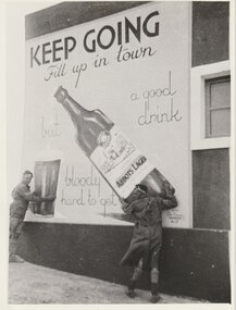
Photograph, A Mural West of Tobruk, 1941
A photo of a mural in Libya painted by a South Australian Sapper of a bottle of Abbots Lager. The photo, and two others, were sent to Melbourne Legacy in 1979 by Legatee Syd Wilson of Yamba NSW. He thought Melbourne Legacy might be able to use them to generate money by selling them for advertising or publicity. He said they were enlargements of snapshots he had found in his old army trunk. The text says 'Keep Going. Fill up in town, but a good drink is bloody hard to get'. Legatee Wilson's letter says the murals were: 'painted on three walls of a white concrete Italian block house (Police Check post I think), some 18/20 miles west of Tobruk, between Tobruk and Derna, and near a captured Italian airfield, somewhere about February 1941. Obviously they were painted by a Victorian Sapper. They were very well done, by a competent Sign-writer/artist, in correct and excellent colours (captured Itie paint no doubt - there was plenty in their Naval Stores at Tobruk).' (NB Itie was slang for Italian) From the AWM website the signs were painted by South Australian painter, SZ538 Sapper Leslie John “Doc” Dawes, 2/3rd Field Company, Royal Australian Engineers. There are several photos on the AWM site including the building the three murals were on.Photos taken by a Legatee when on active service in Libya in World War 2. They were donated to Legacy when it was thought they could be used for fundraising, which shows that Legatees were conscious of that Legacy needs to generate funds to continue its work.Black and white enlargement of a photo taken in Libya of Abbots Lager mural.tobruk, soldiers, lager, beer, abbots lager, murals -
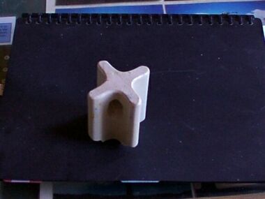
 Parks Victoria - Gabo Island Lightstation
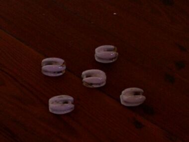
Insulators
Modern communications technology arrived on Gabo Island with the construction of the telegraph line from Eden to Gabo Island in 1870. This type of insulator was usually used with radio antennae wires, telegraph and radio antennae equipment. The items of telegraphic equipment comprise a number of ceramic and glass insulators of varying age and type. Five, knuckle-shaped white glazed ceramic examples are associated with radio antennae wires. In addition to insulators, there is a telephone insulator bracket made of metal with wooden pins. It was once attached to the top of a steel pole and some of these remain in situ along the former telegraph line. Telegraphic communication commenced at the Gabo Lightstation in 1870, just eight years after the lightstation opened. The line from Sydney reached Eden, NSW by 1868 and was then extended to Gabo with the costs shared equally by NSW and Victoria. It was initially carried on posts across the sea to the island but was changed to a line along the seabed after the posts were washed away. The first telegraph office was a timber building on east side of the assistants’ quarters. In 1887 a new concrete telegraph office was built which included quarters for the operator, with Victoria and NSW sharing the construction costs. The 1992 CMP identified remnants of the line from its various phases of operation, and these can still be seen in 2016. Other ceramic insulators in the collection are associated with lines supported on utility poles for the transmission of high voltage electricity. .The various insulators have second level significance for their historic value and provenanceFive white glazed ceramic insulators. Knuckle bone sized, oval shaped with one opening at either end. All five are the same. -
 Parks Victoria - Gabo Island Lightstation
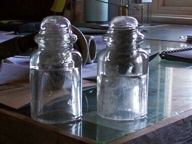
Insulators
Modern communication tecnology arrived on Gabo Island with the construction of the telegraph line from Eden to Gabo Island in 1870. These and other cylindricial insulators were associated with the original 1870 copper wire telegraph line and later the P.M.G. line. The items of telegraphic equipment comprise a number of ceramic and glass insulators of varying age and type. Two bell-shaped insulators are made of clear glass, one with remains of wooden dowel inside. In addition to insulators, there is a telephone insulator bracket made of metal with wooden pins. It was once attached to the top of a steel pole and some of theseremain in situ along the former telegraph line. Telegraphic communication commenced at the Gabo Lightstation in 1870, just eight years after the lightstation opened.The line from Sydney reached Eden, NSW by 1868 and was then extended to Gabo with the costs shared equally by NSW and Victoria. It was initially carried on posts across the sea to the island but was changed to a line along the seabed after the posts were washed away. The first telegraph office was a timber building on east side of the assistants’ quarters. In 1887 a new concrete telegraph office was built which included quarters for the operator, with Victoria and NSW sharing the construction costs. The 1992 CMP identified remnants of the line from its various phases of operation,231 and these can still be seen in 2016. Other ceramic insulators in the collection are associated with lines supported on utility poles for the transmission of high voltage electricity. The various insulators have second level significance for their historic value and provenance1. Clear glass insulator. Cyndrical bottle shape with smaller dome -like knob on top. Hollow with inscription on lower edge. Has remains of wooden dowell inside. 2.Clear glass insulator. Cyndrical bottle shape with smaller dome -like knob on top. Hollow with inscription on lower edge.Around lower edge on opposite sides,"C.C / 42" -
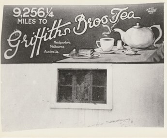 Melbourne Legacy
Photograph, A Mural West of Tobruk, 1941
A photo of a mural in Libya painted by a South Australian Sapper of a tea pot saying '9,256 miles to Griffiths Bros Tea Headquarters, Melbourne'. The photo, and two others, were sent to Melbourne Legacy in 1979 by Legatee Syd Wilson of Yamba NSW. He thought Melbourne Legacy might be able to use them to generate money by selling them for advertising or publicity. He said they were enlargements of snapshots he had found in his old army trunk. The text says '9,256 miles to Griffiths Bros Tea Headquarters, Melbourne'. Legatee Wilson's letter says the murals were: 'painted on three walls of a white concrete Italian block house (Police Check post I think), some 18/20 miles west of Tobruk, between Tobruk and Derna, and near a captured Italian airfield, somewhere about February 1941. Obviously they were painted by a Victorian Sapper. They were very well done, by a competent Sign-writer/artist, in correct and excellent colours (captured Itie paint no doubt - there was plenty in their Naval Stores at Tobruk).' (NB Itie was slang for Italian) From the AWM website the signs were painted by South Australian painter, SZ538 Sapper Leslie John “Doc” Dawes, 2/3rd Field Company, Royal Australian Engineers. There are several photos on the AWM site including the building the three murals were on.Photos taken by a Legatee when on active service in Libya in World War 2. They were donated to Legacy when it was thought they could be used for fundraising, which shows that Legatees were conscious of that Legacy needs to generate funds to continue its work.Black and white enlargement of a photo taken in Libya of a Griffiths Tea mural.tobruk, tea, murals, world war two -
 Eltham District Historical Society Inc
Photograph - Digital Photograph, Marguerite Marshall, Smith Dam, Karingal Drive, Eltham, 19 September 2006
The dam at the entrance to the Nerreman Gateway in Eltham was built according to an internationally acclaimed theory developed by the builder's father. In 1920, Victorian engineer B.A. Smith was awarded the American Society of Civil Engineers J. James R. Cross Gold Medal for his Technical Paper titled 'Arched Dams'. It was the first time this medal had been awarded outside the United States. The concrete arched dam across the Eltham West Drain was built in 1940 by B.A. Smith's son and engineer, D. B. (Bernie) Smith to water the 24 acre (9.75 ha) hobby farm owned by himself and new wife, Isa Smith. Upon completion of the dam a pump-house was constructed beside the creek but before the water could be pumped up the hill they had to dig a trench and lay 500m of 100mm water main to an elevated holding tank. The Smiths made the pump-house their home for several years until they constructed their home at the top of the hill overlooking Eltham and views extending to Kinglake. Following Bernie's death in 1983, Nerreman Park was subdivided between 1993 and 1995. Gordon Ford designed the landscaping and the pump-house was demolished. Covered under Heritage Overlay, Nillumbik Planning Scheme. Published: Nillumbik Now and Then / Marguerite Marshall 2008; photographs Alan King with Marguerite Marshall.; p137This collection of almost 130 photos about places and people within the Shire of Nillumbik, an urban and rural municipality in Melbourne's north, contributes to an understanding of the history of the Shire. Published in 2008 immediately prior to the Black Saturday bushfires of February 7, 2009, it documents sites that were impacted, and in some cases destroyed by the fires. It includes photographs taken especially for the publication, creating a unique time capsule representing the Shire in the early 21st century. It remains the most recent comprehenesive publication devoted to the Shire's history connecting local residents to the past. nillumbik now and then (marshall-king) collection, eltham, karingal drive, smiths dam, bernie smith, gordon ford, isa smith, nerreman gateway, nerreman park estate, dams -
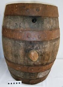 Flagstaff Hill Maritime Museum and Village
Container - Barrel, 19th century
This small barrel looks well used. Unfortunately, the inscription on the barrel is indecipherable so its story is a mystery. However, the bungholes on the side are a clue that it was once used for storing liquid, likely to have been liquor. Barrels have been used over many centuries for transporting and storing a wide range of dry and liquid goods. They are made by tradesmen called coopers, who use heat and steam to bend and shape the wood to suit the work in hand. They add metal reinforcing, handles, spouts and suchlike, to complete they process. Their produce also includes buckets, casks and tubs. Ships transported bulk liquor in their cargo, stored in wooden barrels. The barrels' round shape allowed them to be easily moved by rolling them into place. The body's shape gave the barrels added strength and the iron bands helped the wooden sheaves stay in place. The tops and bottoms allowed for easy grip. The bungholes gave access to government representatives, who would sample the contents, measure the alcohol percentage, and charge the appropriate duty or tax; the process was called Ullaging and the instrument they used was a Hydrometer. Hundreds of barrels of cement were imported into Warrnambool in the late 19th century for the construction of the Warrnambool Breakwater. Barrel-shaped concrete blocks are still visible at shipwreck sites such as on the LOCH ARD wreck, which carried cement among its cargo.This small barrel is representative of 19th century containers used for transportation and storage of liquid such as liquor. It is a historic shape that is still used in modern times.Barrel; wooden barrel, cylindrical shape with metal bands or ribs for reinforcement. The side has two bungholes; one has a bung or stopper. Inscription on top (indecipherable). (indecipherable)flagstaff hill, warrnambool, shipwrecked-coast, flagstaff-hill, flagstaff-hill-maritime-museum, maritime-museum, shipwreck-coast, flagstaff-hill-maritime-village, barrel, cask, small barrel, trade, coopering, cooper, casket, transport, storage, bunghole -
 Port Fairy Historical Society Museum and Archives
Postcard, The Park Port Fairy
Funding for the construction of the Rotunda was bequeathed in the Will of local resident Mrs Annie Williams, who was born in Daylesford in 1872 and died in Kew in 1930. Annie’s Will stipulated that the remaining value of her Estate be spent on erecting a Bandstand in the Port Fairy Botanical Gardens dedicated to the memory of her brother Hugh, a stretcher bearer in WW1 and who died in 1921 after being discharged with health issues, her husband Henry, and herself naturally. There is a plaque dedicated to Annie on the Bandstand She requested that the Bandstand be a replica of the one at Daylesford but by 1933 the value of her Estate had diminished to £76.4/8 which was insufficient to cover a similar design and the Borough Councillors felt it would be too extravagant for the Port Fairy Botanical Gardens. Local builder J.J.McLaren’s tender of £71.15/- was accepted and the octagonal concrete pillared construction was completed with the use of sustenance labour the following year. The Bandstand was opened in December, 1934 with a performance by the Port Fairy Band and local residents enjoying the entertainment and a picnic. In 1934 it was reported that there was some fuss in Council because of the whereabouts of the sum of approximately £3/- , being the amount left over from the build. After some months of debate, in which the Councillors suggested that the Engineer had used the money inappropriately, and to which he responded that the build had cost more than the quote, the matter seems to have ended there Coloured photograph (hand tinted) of the stand of cypress trees leading to the rotundaThe Park, Port Fairy - No. 3botanical, garden, cypress, tree, rotunda -
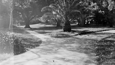 Port Fairy Historical Society Museum and Archives
Photograph
Funding for the construction of the Rotunda was bequeathed in the Will of local resident Mrs Annie Williams, who was born in Daylesford in 1872 and died in Kew in 1930. Annie’s Will stipulated that the remaining value of her Estate be spent on erecting a Bandstand in the Port Fairy Botanical Gardens dedicated to the memory of her brother Hugh, a stretcher bearer in WW1 and who died in 1921 after being discharged with health issues, her husband Henry, and herself naturally. There is a plaque dedicated to Annie on the Bandstand She requested that the Bandstand be a replica of the one at Daylesford but by 1933 the value of her Estate had diminished to £76.4/8 which was insufficient to cover a similar design and the Borough Councillors felt it would be too extravagant for the Port Fairy Botanical Gardens. Local builder J.J.McLaren’s tender of £71.15/- was accepted and the octagonal concrete pillared construction was completed with the use of sustenance labour the following year. The Bandstand was opened in December, 1934 with a performance by the Port Fairy Band and local residents enjoying the entertainment and a picnic. In 1934 it was reported that there was some fuss in Council because of the whereabouts of the sum of approximately £3/- , being the amount left over from the build. After some months of debate, in which the Councillors suggested that the Engineer had used the money inappropriately, and to which he responded that the build had cost more than the quote, the matter seems to have ended there Black and white photograph of gardens with dividing paths and palm treebotanical, rotunda, gardens, trees, bandstand -
 Ballarat Tramway Museum
Photograph - Colour Photograph/s, Carolyn Dean, March to May 2000
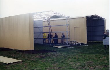
Set of 20 photographs taken by Carolyn Dean of the construction of the new storage sheds at Bungaree and painting of the house during the period 27/3/2000 and 6/5/2000. All on Kodak Paper. .1 - John Phillips concreting at rear of house - 27/3/00 .2 - ditto .3 - Sheds framing - 8/4/00 .4 - ditto .5 - Painting of rear of house - partially done for extensions .6 - ditto .7 - putting the second sheet of cladding on. .8 - ditto, with tower truck in background. .9 - ditto .10 - ditto .11 - Jim Parker painting windows .12 - ditto, painting eaves .13 - ditto .14 - finishing off the wall cladding on the first shed - 9/4/00 .15 - ditto .16 - guttering .17 - ditto .18 - placing roof sheeting on the first shed. .19 - Cladding the second shed - 6/5/00 .20 - wall cladding finished on both sheds.All with dates and "Photo by Carolyn Dean" on rear in blue ink.bungaree, sheds, btm -
 Ballarat Tramway Museum
Photograph - Colour Photograph/s - set of 18, Carolyn Dean, 6/05/2000 12:00:00 AM
Set of 18 photographs of the completion of the sheds and commencing on the house extensions at Bungaree over the period 6/5/00 to 24/6/00. All taken by Carolyn Dean. 6/5/00 1. Cladding the second shed 2. ditto 3. ditto 4. House being repainted and wheels storage 7/5/00 5. Fittings doors to first shed - trail fit 6. House block 7. Roof sheeting to 2nd shed 8. The two sheds 11/6/00 9. The two sheds complete with doors and flashings 10. House with sheds in background (photo used in July 2000 Fares Please! and 1999-2000 Annual Report) 11. ditto 12. House extensions - old shed demolished 13. Modifying pipe work 14. ditto 15. Old foundations 16. Mini mix delivering concrete 17. New slab over old 18. and extending front step.All have date and "Photo by Carolyn Dean" on rear.bungaree, sheds, house extensions -
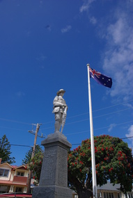
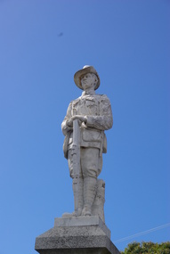
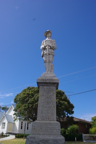
 Ballarat Heritage Services
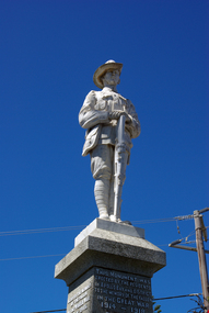
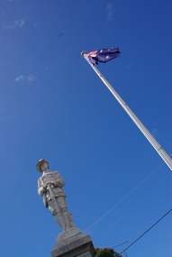
Photograph - Colour, Clare Gervasoni, Apollo Bay War Memorial, 27/01/2013
This memorial was erected by the residents of Apollo Bay and District in 1922.Colour photograph of the War Memorial at Apollo Bay, that features a scuplture of an Australian soldier with slouch hat and holding a rifle. It includes a list of those who served during World War One and World War Two. A characteristic figurative monument, the memorial comprises a single standing soldier, looking down the main street, a top a polished granite pedestal with honour roll set on a huge rock faced granite block.The memorial is fenced by heavy set square concrete bollards supporting heavy gauge chain between each. tBuilt by J. Wilson & Co. of Bendigo, the Apollo Bay Memorial depicts the lone soldier, a typical symbol of the sentiments of communities who had lost faith in heroism and had learnt to recognise the level of loss caused by war amongst ordinary volunteers. This recognition,which occurred throughout Australia, marked a turning point as the 'unknown soldier' was increasingly commemorated instead of military leaders as had previously been the traditional practice. apollo bay war memorial, australian soldier memorial, cawood, mitchell, finlayson, marriner, maguire, mclennan, stephens, vipont, lang, turner, thomson, h.f. smith, a.e. hunt, ormsby, elston, gooday, p. bird, costin, de vere, de forest, j. bowie, c. hughes, r. irving, mcminn, newman, riley, sculley, townsend, thornton, thurst, wright, j. wilson, stonemason -
 Ballarat Heritage Services
Photograph - Colour, Clare Gervasoni, Apollo Bay War Memorial, 26/01/2016
This memorial was erected by the residents of Apollo Bay and District in 1922.Colour photograph of the War Memorial at Apollo Bay, that features a scuplture of an Australian soldier with slouch hat and holding a rifle. It includes a list of those who served during World War One and World War Two. A characteristic figurative monument, the memorial comprises a single standing soldier, looking down the main street, a top a polished granite pedestal with honour roll set on a huge rock faced granite block.The memorial is fenced by heavy set square concrete bollards supporting heavy gauge chain between each. tBuilt by J. Wilson & Co. of Bendigo, the Apollo Bay Memorial depicts the lone soldier, a typical symbol of the sentiments of communities who had lost faith in heroism and had learnt to recognise the level of loss caused by war amongst ordinary volunteers. This recognition,which occurred throughout Australia, marked a turning point as the 'unknown soldier' was increasingly commemorated instead of military leaders as had previously been the traditional practice. apollo bay war memorial, australian soldier memorial, cawood, mitchell, finlayson, marriner, maguire, mclennan, stephens, vipont, lang, turner, thomson, h.f. smith, a.e. hunt, ormsby, elston, gooday, p. bird, costin, de vere, de forest, j. bowie, c. hughes, r. irving, mcminn, newman, riley, sculley, townsend, thornton, thurst, wright, j. wilson, stonemason -
 Ballarat Heritage Services
Photograph - Colour, Clare Gervasoni, Apollo Bay War Memorial, 27/01/2013
This memorial was erected by the residents of Apollo Bay and District in 1922.Colour photograph of the War Memorial at Apollo Bay, that features a scuplture of an Australian soldier with slouch hat and holding a rifle. It includes a list of those who served during World War One and World War Two. A characteristic figurative monument, the memorial comprises a single standing soldier, looking down the main street, a top a polished granite pedestal with honour roll set on a huge rock faced granite block.The memorial is fenced by heavy set square concrete bollards supporting heavy gauge chain between each. tBuilt by J. Wilson & Co. of Bendigo, the Apollo Bay Memorial depicts the lone soldier, a typical symbol of the sentiments of communities who had lost faith in heroism and had learnt to recognise the level of loss caused by war amongst ordinary volunteers. This recognition,which occurred throughout Australia, marked a turning point as the 'unknown soldier' was increasingly commemorated instead of military leaders as had previously been the traditional practice. apollo bay war memorial, australian soldier memorial, cawood, mitchell, finlayson, marriner, maguire, mclennan, stephens, vipont, lang, turner, thomson, h.f. smith, a.e. hunt, ormsby, elston, gooday, p. bird, costin, de vere, de forest, j. bowie, c. hughes, r. irving, mcminn, newman, riley, sculley, townsend, thornton, thurst, wright, j. wilson, stonemason -
 Ballarat Heritage Services
Photograph - Colour photograph, Clare Gervasoni, Apollo Bay War Memorial, 27/01/2013
This memorial was erected by the residents of Apollo Bay and District in 1922.Colour photograph of the War Memorial at Apollo Bay, that features a scuplture of an Australian soldier with slouch hat and holding a rifle. It includes a list of those who served during World War One and World War Two. A characteristic figurative monument, the memorial comprises a single standing soldier, looking down the main street, a top a polished granite pedestal with honour roll set on a huge rock faced granite block.The memorial is fenced by heavy set square concrete bollards supporting heavy gauge chain between each. Built by J. Wilson & Co. of Bendigo, the Apollo Bay Memorial depicts the lone soldier, a typical symbol of the sentiments of communities who had lost faith in heroism and had learnt to recognise the level of loss caused by war amongst ordinary volunteers. This recognition,which occurred throughout Australia, marked a turning point as the 'unknown soldier' was increasingly commemorated instead of military leaders as had previously been the traditional practice. apollo bay war memorial, australian soldier memorial, cawood, mitchell, finlayson, marriner, maguire, mclennan, stephens, vipont, lang, turner, thomson, h.f. smith, a.e. hunt, ormsby, elston, gooday, p. bird, costin, de vere, de forest, j. bowie, c. hughes, r. irving, mcminn, newman, riley, sculley, townsend, thornton, thurst, wright, j. wilson, stonemason -
 Ballarat Heritage Services
Photograph - Colour, Clare Gervasoni, Apollo Bay War Memorial, 2013, 26/01/2013
This memorial was erected by the residents of Apollo Bay and District in 1922.Colour photograph of the War Memorial at Apollo Bay, that features a scuplture of an Australian soldier with slouch hat and holding a rifle. It includes a list of those who served during World War One and World War Two. A characteristic figurative monument, the memorial comprises a single standing soldier, looking down the main street, a top a polished granite pedestal with honour roll set on a huge rock faced granite block.The memorial is fenced by heavy set square concrete bollards supporting heavy gauge chain between each. tBuilt by J. Wilson & Co. of Bendigo, the Apollo Bay Memorial depicts the lone soldier, a typical symbol of the sentiments of communities who had lost faith in heroism and had learnt to recognise the level of loss caused by war amongst ordinary volunteers. This recognition,which occurred throughout Australia, marked a turning point as the 'unknown soldier' was increasingly commemorated instead of military leaders as had previously been the traditional practice. apollo bay war memorial, australian soldier memorial, cawood, mitchell, finlayson, marriner, maguire, mclennan, stephens, vipont, lang, turner, thomson, h.f. smith, a.e. hunt, ormsby, elston, gooday, p. bird, costin, de vere, de forest, j. bowie, c. hughes, r. irving, mcminn, newman, riley, sculley, townsend, thornton, thurst, wright, j. wilson, stonemason -
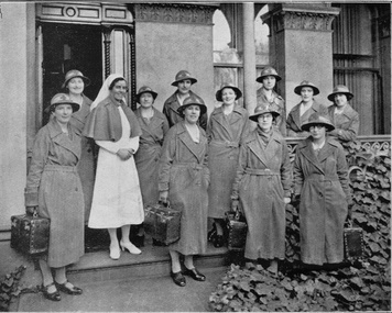 Royal District Nursing Service (now known as Bolton Clarke)
Photograph - Digital image, c.1935
Matron F. L. Gordon and the Sisters are standing in front of the Melbourne District Nursing Society (MDNS) Nurses Home at 39 Victoria Parade, Collingwood. The Nurses lived in this residence from 1914-1953. In 1926 the After-Care Home was built next door. This image was taken twelve months after the name of the Society changed from 'Melbourne District Nursing Society After Care 'Home' to 'Hospital'. The photograph shows the uniform of the District Division of the Melbourne District Nursing Society in the 1930s, with the uniform dress made of grey cotton. Their brimmed hat was made of felt with a cotton hat band with a red Maltese cross in the centre front. From its founding in 1885 until 1891 the Trained nurses, called 'Nurse' in those days, of the Melbourne District Nursing Society (MDNS) worked from their own homes which were located in the vicinity of their areas (districts). In November 1891 MDNS was able to rent a two story terraced house at 66 Cardigan Street, Carlton, at £65 a year, which contained accommodation for three Nurses and one pupil nurse as well as being used as their Headquarters. They left from their Nurses Home each morning and returned at the end of their shift to write up their book work before retiring for the day. Three years later, in 1894, they moved into a larger terraced house at 49 Drummond Street Carlton which was rented at ‘a very moderate rental’. There was a Board room, apartments for the Nurses and pupil nurse, a large dispensary which patients could attend each evening to have prescriptions signed and bottles refilled with ‘homely remedies’ and elixirs, which were administered for e.g. Consumptive cases. Doctor’s prescriptions were filled at the Pharmacy. Cupboards containing donated blankets and bedclothes for needy patients were kept in this room, and it was here where the Nurses kept their nursing bags which were refilled at the end of each shift ready for any emergency and for the next day. A list of Doctors the Nurses could call was kept by the telephone. The Home also had a kitchen where nourishing soup was made and distributed twice a week to the needy. Milk was also distributed when needed. In 1902 they moved into rented premises at 188 Leicester Street, Carlton and two years later, in 1904, to premises at 5 Royal Terrace, Nicholson Street, Fitzroy. They remained there for ten years and an Auction of furniture was held before their next move giving an idea of some of the contents: - Carpets, linoleum, walnut and oak sideboards, dining tables, walnut dining suite, Vienna chairs, walnut bedroom suite, cedar wardrobes, chests of drawers, duchess chests, bedsteads and bedding and general furnishings were for sale. In June 1914 at last the Society had sufficient funding to purchase their own terraced premises, ‘Floraston’ 39 Victoria Parade, Collingwood which became their Headquarters and Nurses Home. In 1926 the After-Care Home for recovering patients, (later called After-Care Hospital) was built by the Society next door, running from 41-47 Victoria Parade (became No. 45); the District Sisters continued to live at No. 39. In November 1953 the District Nursing Division moved into their new Headquarters and Nurses Home at 452 St. Kilda Road, Melbourne, with a change of name to Melbourne District Nursing Service in 1957. With Royal patronage, this changed to Royal District Nursing Service (RDNS) in 1966. As District expanded, and now with outlying districts to service and with a full fleet of District cars, Sisters lived in their own homes and visited their District Centre each morning to collect their work for the day and returned there at the end of their days work in the community to carry out their administrative work. The digital image shows Matron, Miss F.L. Gordon, wearing a white uniform and veil and a dark coloured cape standing amid a group of eleven District Trained nurses (Sisters), from the Melbourne District Nursing Society (MDNS). Two Sisters are to her left and the others to her right. They are standing in front of a grey building. The Sisters are wearing their uniforms of grey long coats with lapels; the coat is secured with a belt around the waist. This is worn over their grey uniforms, with white collars. Each Sister is wearing their uniform grey brimmed hat with a Maltese cross attached to the light hatband, and are carrying a square shaped nursing case. They are standing in two rows, with some on the veranda of the building and some in front on the path; two Sisters are just off the path amid the shrubs. Part of the grey concrete building can be seen behind the Sisters with the open door to the left and part of three long windows seen to its right. One Sister has her lower left arm resting on the veranda rail.'Miss F.L. Gordon, Matron, and some of the District Sisters'mdns, melbourne district nursing society, 39 victoria parade, collingwood, rdns, royal district nursing service, nurses home, miss f.l. gordon, mdns uniforms, mdns matron -
 Eltham District Historical Society Inc
Negative - Photograph, Burgoyne family outside J.N. Burgoyne's Store, Main Road, Eltham, Vic, 1940
The store built in 1925 was located on Main Road just south of Bridge Street (present day No. 820 Main Road). An extension was added to the right in 1939. The store was built in late 1925 at the same time as Mr C. Nicholls’s new store was constructed. Both were considered modern shops, and an improvement on most, business establishments of the time. Mr. Nicholls’s store included alongside it a modern, weatherboard villa residence. Mr. Burgoyne’s store incorporated the post and telegraph office, which was operated by John Neville Burgoyne’s half-aunt, Miss Anne Hunniford until her death in 1928 at which time J.N. Burgoyne became postmaster. The unsealed footpath in front is reasonably extensive as not visible is a concrete kerb and channel which was laid from the Post Office to John Street during Nov-Dec 1926. Footpath construction in front of Burgoyne’s store commenced August 1942. The extension to the right of the store was erected in 1939 for a new telephone exchange adjacent to the store and post office. A continuous telephone service operated by Mr Burgoyne and his family commenced operation 18 November 1939. Approximately 70 extensions were routed through the new exchange, 40 of which were transferred from the Greensborough Exchange. Entry to the exchange was via a separate door on Main Road or via the shop. The public telephone was initially mounted on the wall but later moved to the street. Cross Ref: 0701 of the store c.1934This photo forms part of a collection of photographs gathered by the Shire of Eltham for their centenary project book,"Pioneers and Painters: 100 years of the Shire of Eltham" by Alan Marshall (1971). The collection of over 500 images is held in partnership between Eltham District Historical Society and Yarra Plenty Regional Library (Eltham Library) and is now formally known as the 'The Shire of Eltham Pioneers Photograph Collection.' It is significant in being the first community sourced collection representing the places and people of the Shire's first one hundred years.Digital image 4 x 5 inch B&W Negshire of eltham pioneers photograph collection, burgoyne's shop, eltham, main road, post office, shops